|
|
|
0 members (),
1,047
guests, and
53
robots. |
|
Key:
Admin,
Global Mod,
Mod
|
|
S |
M |
T |
W |
T |
F |
S |
|
|
|
|
|
|
|
1
|
|
2
|
3
|
4
|
5
|
6
|
7
|
8
|
|
9
|
10
|
11
|
12
|
13
|
14
|
15
|
|
16
|
17
|
18
|
19
|
20
|
21
|
22
|
|
23
|
24
|
25
|
26
|
27
|
28
|
29
|
|
30
|
31
|
|
|
|
|
|
|
There are no members with birthdays on this day. |

Volcano earthquake report for Sunday, 16 Aug 2026
• Moderate mag. 4.4 earthquake - Fukuoka, Japan, on Monday, Aug 17, 2026, at ...
• Moderate mag. 4.7 earthquake - Banda Sea, 78 km east of Pulau Banda Besar I...
• Moderate mag. 4.4 earthquake - Banda Sea, 46 km north of Pulau Dai Island, ...
• World Earthquake Report for Sunday, 16 August 2026
• Magnitude 5.2 earthquake strikes near San Antonio de los Cobres, Los Andes ...
|

#747636
Mon 16 Dec 2024 07:31:PM
|
Joined: Feb 2001
Posts: 678,976
Launch Director
|
OP

Launch Director
Joined: Feb 2001
Posts: 678,976 |
SPC Dec 16, 2024 1930 UTC Day 3 Severe Thunderstorm OutlookSPC 1930Z Day 3 Outlook 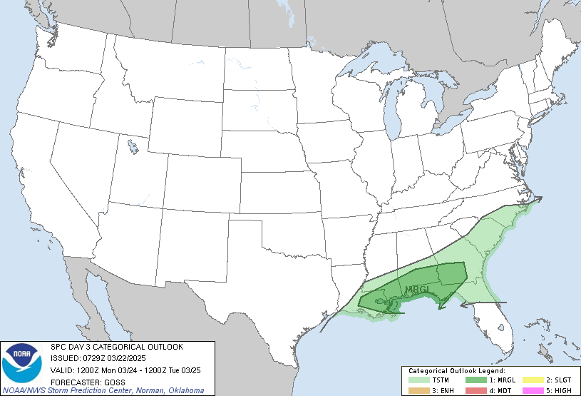
Day 3 Convective Outlook
NWS Storm Prediction Center Norman OK
0129 PM CST Mon Dec 16 2024

Valid 181200Z - 191200Z

...NO SEVERE THUNDERSTORM AREAS FORECAST...

...SUMMARY...
Thunderstorms are possible from the lower Ohio Valley southwest into
northeast/central Texas early on Wednesday and across the Southeast,
Carolinas, and Florida Wednesday afternoon and evening.

...Synopsis...
An upper trough will migrate across the eastern half of the CONUS on
Wednesday. Boundary-layer moisture will remain modest across the
southeast U.S., ahead of a southeast-advancing cold front extending
from southern OH southwest to western TN and then central TX
Wednesday morning. Isolated showers and thunderstorms are likely to
be ongoing along the front at the beginning of the period. This
activity will likely be elevated and just to the cool side of the
surface front. Instability is expected to be very weak with
southeast extent into the TN and Lower MS Valley, and morning
thunderstorms will likely diminish in coverage as the front moves
southeast. Severe thunderstorms are unlikely given limited
instability and modest vertical shear.

Additional thunderstorms are possible across Florida and coastal
Georgia where persistent easterly flow will continue to advect
somewhat richer low-level moisture inland. In addition to this
activity, isolated to scattered thunderstorms are possible across
Georgia and the Carolinas as isentropic ascent increases with a
modest low-level jet response ahead of the approaching mid-level
trough. Predictability remains low with this potential as the
mid-level vorticity maximum will trail well behind the cold front.
Weak upper-level support combined with relatively weak isentropic
ascent is the primary limiting factor for severe weather potential
across Georgia and the Carolinas Wednesday afternoon/evening.

..Bentley.. 12/16/2024
Read morehttps://www.spc.noaa.gov/products/outlook/day3otlk_1930.html
|
|



CMS The Best Conveyancing solicitors conveyancing quotes throughout the UK
For any webhosting enquiries please email webmaster@aus-city.com
|
|
Forums60
Topics797,246
Posts832,036
Members2,960
| |
Most Online102,106
Jul 10th, 2026
|
|
|
|
|

|





































