|
|
|
0 members (),
958
guests, and
20
robots. |
|
Key:
Admin,
Global Mod,
Mod
|
|
S |
M |
T |
W |
T |
F |
S |
|
|
|
|
|
|
|
1
|
|
2
|
3
|
4
|
5
|
6
|
7
|
8
|
|
9
|
10
|
11
|
12
|
13
|
14
|
15
|
|
16
|
17
|
18
|
19
|
20
|
21
|
22
|
|
23
|
24
|
25
|
26
|
27
|
28
|
29
|
|
30
|
|
|
|
|
|
|
|
There are no members with birthdays on this day. |

#748970
Sun 29 Dec 2024 12:28:AM
|
Joined: Feb 2001
Posts: 381,904
Launch Director
|
OP

Launch Director
Joined: Feb 2001
Posts: 381,904 |
Small magnitude 3.6 quake hits 42 miles southeast of Eureka, California, United States in the afternoon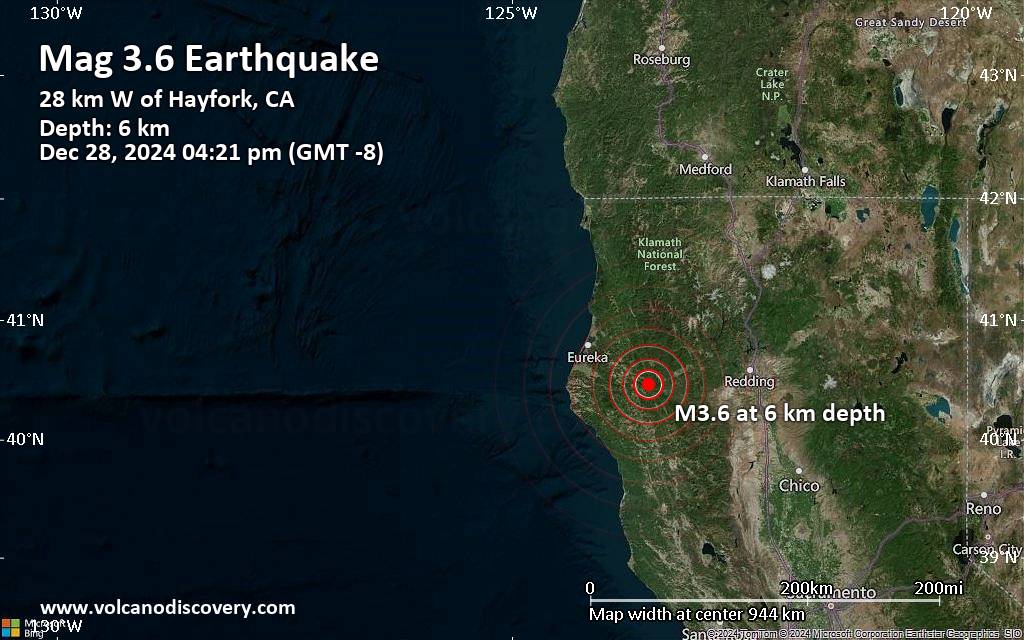 An earthquake of magnitude 3.6 occurred in the afternoon on Saturday, December 28th, 2024, at 4:21 pm local time near Eureka, Humboldt County, California, USA, as reported by the United States Geological Survey.
According to preliminary data, the quake was located at a very shallow depth of 3.9 miles. Shallow earthquakes are felt more strongly than deeper ones as they are closer to the surface. The exact magnitude, epicenter, and depth of the quake might be revised within the next few hours or minutes as seismologists review data and refine their calculations, or as other agencies issue their report.
A second report was later issued by the European-Mediterranean Seismological Centre (EMSC), which listed it as a magnitude 3.6 earthquake as well.
Based on the preliminary seismic data, the quake should not have caused any significant damage, but was probably felt by many people as light vibration in the area of the epicenter.
Weak shaking might have been felt in Mad River (pop. 420) located 1 miles from the epicenter.
Other towns or cities near the epicenter where the quake might have been felt as very weak shaking include Hayfork (pop. 2,400) located 18 miles from the epicenter, Rio Dell (pop. 3,400) 32 miles away, and Fortuna (pop. 12,000) 36 miles away. In Bayside (pop. 17,100, 39 miles away), Arcata (pop. 17,800, 41 miles away), Eureka (pop. 27,000, 42 miles away), and McKinleyville (pop. 15,200, 46 miles away), the quake was probably not felt.
Earthquake data: Date & time: Dec 28, 2024 04:21 pm (GMT -8) local time (29 Dec 2024 00:21 GMT)Magnitude: 3.6 Depth: 6.3 km Epicenter latitude / longitude: 40.47°N / 123.5°W  ( Trinity, California, United States) Primary data source: USGShttps://www.volcanodiscovery.com/earthquake/news/260973/Small-magnitude-36-quake-hits-42-miles-southeast-of-Eureka-California-United-States-in-the-afternoon.html
|
|


CMS The Best Conveyancing solicitors conveyancing quotes throughout the UK
For any webhosting enquiries please email webmaster@aus-city.com
|
|
Forums60
Topics746,609
Posts781,263
Members2,958
| |
Most Online4,158
Jun 21st, 2024
|
|
|
|
|
Copyright 1996 - 2024 by David Cottle. Designed by David Bate Jr. All Rights Reserved.
By using this forum, the user agrees not to transfer any data or technical information received under the agreement, to any other entity without the express approval of the AUS-CITY Forum Admins and/or authors of individual posts (Forum Admins and DoD/USSPACECOM for the analysis of satellite tracking data).
Two-line elements (TLE) and all other satellite data presented and distributed via this forum and e-mail lists of AUS-CITY are distributed with permission from DoD/USSTRATCOM.

Reprise Hosting

|

|


 - Click image for larger picture.")


