|
|
|
0 members (),
5,332
guests, and
25
robots. |
|
Key:
Admin,
Global Mod,
Mod
|
|
S |
M |
T |
W |
T |
F |
S |
|
|
|
1
|
2
|
3
|
4
|
5
|
|
6
|
7
|
8
|
9
|
10
|
11
|
12
|
|
13
|
14
|
15
|
16
|
17
|
18
|
19
|
|
20
|
21
|
22
|
23
|
24
|
25
|
26
|
|
27
|
28
|
29
|
30
|
|
|
|
|
There are no members with birthdays on this day. |

Small magnitude 3.6 earthquake strikes near Great Falls, Cascade County, Montana, USA
• Volcano earthquake report for Friday, 18 September 2026
• Possible earthquake reported minutes ago near Great Falls, Montana, USA
• Magnitude 4.6 earthquake strikes near Ponce, Segundo Barrio, Ponce Municipi...
• Small magnitude 3.4 earthquake strikes near Skegness, Lincolnshire, England...
• World Earthquake Report for Friday, 18 September 2026
|

#757112
Tue 11 Mar 2025 07:25:PM
|
Joined: Feb 2001
Posts: 678,977
Launch Director
|
|
Launch Director
Joined: Feb 2001
Posts: 678,977 |
SPC Mar 11, 2025 1930 UTC Day 3 Severe Thunderstorm OutlookSPC 1930Z Day 3 Outlook 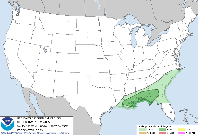
Day 3 Convective Outlook
NWS Storm Prediction Center Norman OK
0224 PM CDT Tue Mar 11 2025

Valid 131200Z - 141200Z

...THERE IS A MARGINAL RISK OF SEVERE THUNDERSTORMS OVER PARTS OF
THE SOUTHEAST...

...SUMMARY...
A few strong to severe thunderstorms are possible from eastern
Mississippi into Alabama and far western Georgia on Thursday.

...Synopsis...
On Thursday, a shortwave trough will move quickly east across the
Gulf Coast states, and completely offshore by late evening. High
pressure will extend westward toward FL, which in combination with
increasingly westerly winds aloft, will minimize moisture return
over parts of the area. To the west, a deep upper trough along the
West Coast will move into the Great Basin and Southwest during the
day, moving quickly toward the central and southern Plains by 12Z
Friday and providing windy conditions.

...Southeast...
Dewpoints well into the 50s will exist across the lower MS Valley
eastward across AL and GA, with lower 60s F closer to the Gulf
Coast. Little in the way of synoptic boundaries will be present at
the surface, but outflows and/or ongoing thunderstorms may provide
further focus for daytime development from northern MS across AL and
into western GA and the FL Panhandle. Areas of heating along with
strong northwest flow aloft may support strong to severe storms
ongoing throughout the day, with hail and localized wind potential.
Given the flow regime, a cell or two may persist with hail potential
east of the moist axis.

..Jewell.. 03/11/2025
Read morehttps://www.spc.noaa.gov/products/outlook/day3otlk_1930.html
|
|



CMS The Best Conveyancing solicitors conveyancing quotes throughout the UK
For any webhosting enquiries please email webmaster@aus-city.com
|
|
Forums60
Topics830,744
Posts865,539
Members2,960
| |
Most Online102,106
Jul 10th, 2026
|
|
|
|
|

|





































