|
0 members (),
1,318
guests, and
18
robots. |
|
Key:
Admin,
Global Mod,
Mod
|
|
S |
M |
T |
W |
T |
F |
S |
|
|
|
|
|
|
|
1
|
|
2
|
3
|
4
|
5
|
6
|
7
|
8
|
|
9
|
10
|
11
|
12
|
13
|
14
|
15
|
|
16
|
17
|
18
|
19
|
20
|
21
|
22
|
|
23
|
24
|
25
|
26
|
27
|
28
|
29
|
|
30
|
31
|
|
|
|
|
|
|
There are no members with birthdays on this day. |
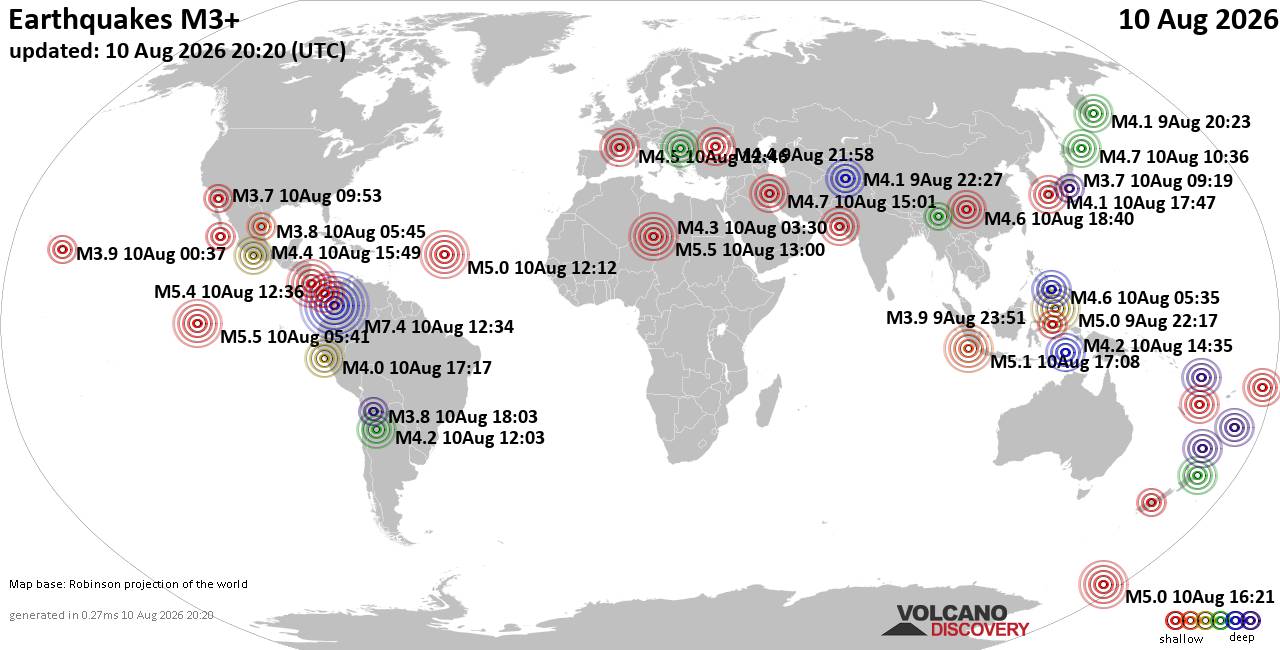
World Earthquake Report for Monday, 10 August 2026
• Volcano earthquake report for Monday, 10 Aug 2026
• Moderate mag. 4.0 earthquake - Zangilan Rayon, 58 km southwest of Ganja, Ga...
• Moderate mag. 4.6 earthquake - 31 km northeast of Xunchang, Sichuan, China,...
• Moderate mag. 4.2 earthquake - New Zealand on Tuesday, Aug 11, 2026, at 06:...
• World Earthquake Report for August 2026
|

#765241
Tue 17 Jun 2025 09:56:PM
|
Joined: Feb 2001
Posts: 678,976
Launch Director
|
OP

Launch Director
Joined: Feb 2001
Posts: 678,976 |
SPC Day 3-8 Fire Weather OutlookSPC Day 3-8 Fire Weather Outlook 
Day 3-8 Fire Weather Outlook
NWS Storm Prediction Center Norman OK
0451 PM CDT Tue Jun 17 2025

Valid 191200Z - 251200Z

...Day 3-4/Thursday-Friday...
An upper-level trough will begin to enter the Pacific Northwest Day
3/Thursday while upper-level ridging shifts eastward into the
Plains. Increased mid-level flow atop a dry/well-mixed boundary
layer will bring an expansive fire weather threat much of the Great
Basin and Colorado Plateau in the form of breezy southwest winds and
low relative humidity. A mid-level wind maxima rounding the southern
periphery of an upper-level low then pushing into the Pacific
Northwest will support even stronger southwest winds of 20-30 mph
(locally higher in favored downslope regions) across much of
central/southern Utah, northern Arizona and far western Colorado as
well as northwestern Nevada where fuels have become increasingly
supportive of wildfire spread. 70 percent probability of Critical
fire weather conditions have been maintained and expanded within
these areas.

...Day 5-8/Saturday-Tuesday...
The warm, dry and breezy conditions supportive of wildfire growth in
dry fuels will shift southeastward towards the upper Colorado River
Basin and northern Arizona by the weekend. Magnitude of winds will
wane by early next week as mid-level flow relaxes and shifts
northeastward. However, the combination of increasingly dry fuels,
drought and lack of rainfall will support an ongoing fire weather
threat through Day 8/Tuesday across much of southeastern Utah,
northern Arizona and far western Colorado.

...California Central Valley...
Dry, post-frontal northerly flow along with low relative humidity
and cured grasses will support at least an Elevated fire weather
threat on Day 5/Saturday across the Central Valley.

..Williams.. 06/17/2025

...Please see www.spc.noaa.gov/fire for graphic product...
Read morehttps://www.spc.noaa.gov/products/exper/fire_wx/
|
|



CMS The Best Conveyancing solicitors conveyancing quotes throughout the UK
For any webhosting enquiries please email webmaster@aus-city.com
|
|
Forums60
Topics796,363
Posts831,153
Members2,960
| |
Most Online102,106
Jul 10th, 2026
|
|
|





































