|
|
|
0 members (),
2,805
guests, and
26
robots. |
|
Key:
Admin,
Global Mod,
Mod
|
|
S |
M |
T |
W |
T |
F |
S |
|
1
|
2
|
3
|
4
|
5
|
6
|
7
|
|
8
|
9
|
10
|
11
|
12
|
13
|
14
|
|
15
|
16
|
17
|
18
|
19
|
20
|
21
|
|
22
|
23
|
24
|
25
|
26
|
27
|
28
|
|
There are no members with birthdays on this day. |

#767688
Fri 11 Jul 2025 08:46:PM
|
Joined: Feb 2001
Posts: 381,904
Launch Director
|
OP

Launch Director
Joined: Feb 2001
Posts: 381,904 |
Magnitude 2.8 earthquake strikes near Kalgoorlie-Boulder, Kalgoorlie/Boulder, Western Australia, Australia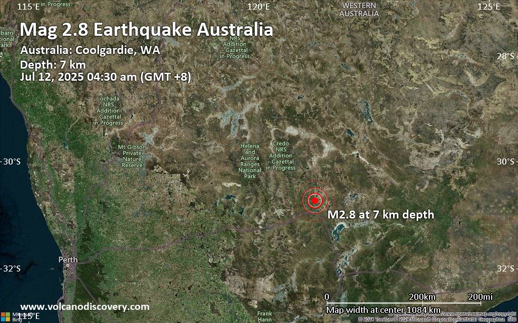 A magnitude 2.8 earthquake near Kalgoorlie-Boulder, Kalgoorlie/Boulder, Western Australia, Australia, was reported only 15 minutes ago by Geoscience Australia (GeoAu), considered the main national agency that monitors seismic activity in Australia. The earthquake occurred at a very shallow depth of 4.3 miles beneath the epicenter early morning on Saturday, July 12th, 2025, at 4:30 am local time. The exact magnitude, epicenter, and depth of the quake might be revised within the next few hours or minutes as seismologists review data and refine their calculations, or as other agencies issue their report.
A second report was later issued by the European-Mediterranean Seismological Centre (EMSC), which listed it as a magnitude 2.8 earthquake as well.
Towns or cities near the epicenter where the quake might have been felt as very weak shaking include Mount Burges (pop. 100) located 10 miles from the epicenter. In Karlkurla (pop. 170, 14 miles away), West Lamington (pop. 1,400, 14 miles away), Coolgardie (pop. 860, 15 miles away), Kalgoorlie-Boulder (pop. 4,200, 15 miles away), Williamstown (pop. 140, 16 miles away), Stoneville (pop. 2,800, 34 miles away), Kambalda West (pop. 1,700, 40 miles away), and Kambalda East (pop. 1,200, 42 miles away), the quake was probably not felt.
Earthquake data: Date & time: Jul 12, 2025 04:30 am (GMT +8) local time (11 Jul 2025 20:30 GMT)Magnitude: 2.8 Depth: 6.89 km Epicenter latitude / longitude: 30.74°S / 121.22°E  ( Coolgardie, Western Australia, Australia) Primary data source: GeoAuhttps://www.volcanodiscovery.com/earthquake/news/275377/Magnitude-28-earthquake-strikes-near-Kalgoorlie-Boulder-KalgoorlieBoulder-Western-Australia-Australi.html
|
|


CMS The Best Conveyancing solicitors conveyancing quotes throughout the UK
For any webhosting enquiries please email webmaster@aus-city.com
|
|
Forums60
Topics760,905
Posts795,629
Members2,957
| |
Most Online17,963
Jan 15th, 2026
|
|
|
|
|
Copyright 1996 - 2026 by David Cottle. Designed by David Bate Jr. All Rights Reserved.
By using this forum, the user agrees not to transfer any data or technical information received under the agreement, to any other entity without the express approval of the AUS-CITY Forum Admins and/or authors of individual posts (Forum Admins and DoD/USSPACECOM for the analysis of satellite tracking data).
Two-line elements (TLE) and all other satellite data presented and distributed via this forum and e-mail lists of AUS-CITY are distributed with permission from DoD/USSTRATCOM.

Reprise Hosting

|

|


 - Click image for larger picture.")


