|
|
|
0 members (),
3,077
guests, and
24
robots. |
|
Key:
Admin,
Global Mod,
Mod
|
|
S |
M |
T |
W |
T |
F |
S |
|
|
|
|
1
|
2
|
3
|
4
|
|
5
|
6
|
7
|
8
|
9
|
10
|
11
|
|
12
|
13
|
14
|
15
|
16
|
17
|
18
|
|
19
|
20
|
21
|
22
|
23
|
24
|
25
|
|
26
|
27
|
28
|
29
|
30
|
31
|
|
|
There are no members with birthdays on this day. |

Volcano earthquake report for Friday, 10 Jul 2026
• Moderate mag. 4.2 earthquake - 133 km northwest of Ternate, Kota Ternate, N...
• World Earthquake Report for Friday, 10 July 2026
• Moderate mag. 4.6 earthquake - 17 km southwest of Comalapa, Estado de Chiap...
• Moderate mag. 4.1 earthquake - Olyutorskiy Rayon, 47 km northwest of Tilich...
• Moderate mag. 4.0 earthquake - Hawke's Bay, New Zealand, on Saturday, Jul 1...
|

#774197
Tue 09 Sep 2025 05:34:PM
|
Joined: Feb 2001
Posts: 678,976
Launch Director
|
OP

Launch Director
Joined: Feb 2001
Posts: 678,976 |
SPC Sep 9, 2025 1730 UTC Day 2 Convective OutlookSPC 1730Z Day 2 Outlook 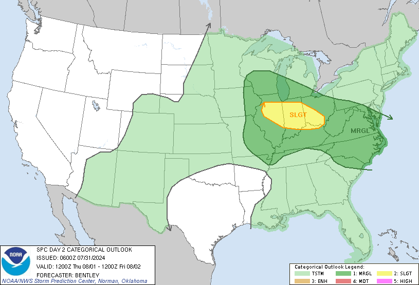
Day 2 Convective Outlook
NWS Storm Prediction Center Norman OK
1230 PM CDT Tue Sep 09 2025

Valid 101200Z - 111200Z

...NO SEVERE THUNDERSTORM AREAS FORECAST...

...SUMMARY...
Scattered showers and thunderstorms are possible over parts of the
Northwest and northern Rockies with more isolated storms over the
High Plains Wednesday. A stronger storm or two is possible, but
severe potential is overall low.

...Synopsis...
An upper-level ridge will strengthen across the central CONUS on
Wednesday with a trough across the West Coast and a deepening trough
in the Great Lakes. Surface high pressure will dominate much of the
eastern CONUS with low pressure across the Great Basin and weak lee
troughing across the High Plains.

...Discussion...
A dry, continental airmass will keep convection suppressed across
much of the eastern CONUS. Widespread convection is anticipated
across the Northwest, northern Great Basin, and the Southwest into
the Central Rockies in the diffluent region ahead of the mid-level
trough. These storms will be somewhat dry in nature with PWAT values
around 0.5 to 0.75 inches and steep low-level lapse rates.
Therefore, a few stronger downbursts are possible with isolated
severe wind gusts. However, relatively weak instability should limit
the overall severe potential across the west.

Greater instability will exist across the Plains, but building
heights aloft will likely keep storm coverage somewhat isolated. A
remnant MCS from Day 1 convection across western Kansas may persist
into the morning hours, but should be weakening through the morning
as it moves east of the low-level jet axis. Some guidance, such as
the NAM, shows significant augmentation of the mid-level height
field which could suppress heights enough for isolated thunderstorm
activity near the remnant outflow/MCV from morning convection on
Wednesday afternoon. However, this scenario is uncertain, and even
if it does occur, shear will likely be relatively weak and
therefore, any severe threat should be isolated.

..Bentley.. 09/09/2025
Read morehttps://www.spc.noaa.gov/products/outlook/day2otlk_1730.html
|
|



CMS The Best Conveyancing solicitors conveyancing quotes throughout the UK
For any webhosting enquiries please email webmaster@aus-city.com
|
|
Forums60
Topics789,860
Posts824,638
Members2,960
| |
Most Online102,106
Jul 10th, 2026
|
|
|
|
|
Copyright 1996 - 2026 by David Cottle. Designed by David Bate Jr. All Rights Reserved.
By using this forum, the user agrees not to transfer any data or technical information received under this agreement to any other entity without the express approval of the AUS-CITY Forum Admins and/or authors of individual posts (Forum Admins and DoD/USSPACECOM for the analysis of satellite tracking data).
Two-line elements (TLE) and all other satellite data presented and distributed via this forum and AUS-CITY mailing lists are distributed with permission from DoD/USSTRATCOM.

|

|




































