|
|
|
0 members (),
2,107
guests, and
23
robots. |
|
Key:
Admin,
Global Mod,
Mod
|
|
S |
M |
T |
W |
T |
F |
S |
|
|
|
|
|
1
|
2
|
3
|
|
4
|
5
|
6
|
7
|
8
|
9
|
10
|
|
11
|
12
|
13
|
14
|
15
|
16
|
17
|
|
18
|
19
|
20
|
21
|
22
|
23
|
24
|
|
25
|
26
|
27
|
28
|
29
|
30
|
31
|
|
There are no members with birthdays on this day. |

#784379
Thu 13 Nov 2025 10:49:AM
|
Joined: Feb 2001
Posts: 381,904
Launch Director
|
OP

Launch Director
Joined: Feb 2001
Posts: 381,904 |
Small magnitude 2.8 earthquake 18 km east of Paphos, Cyprus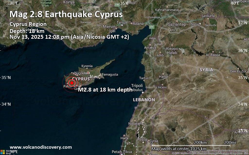 An earthquake of magnitude 2.8 occurred 39 minutes ago 18 km east of Paphos, Cyprus, the European-Mediterranean Seismological Centre (EMSC) reported.
The quake hit at a shallow depth of 18. km beneath the epicenter near Paphos, Pafos, Cyprus, around noon on Thursday, November 13th, 2025, at 12:08 pm local time. Magnitude and other quake parameters can still change in the coming hours as the agency continues to process seismic data.
Our monitoring service identified a second report from Turkey's Disaster and Emergency Management Authority (AFAD) which listed the quake at magnitude 2.7. Other agencies reporting the same quake include The Cyprus Geological Survey (CGS) at magnitude 2.8, the Kandilli Oservatory and Earthquake Research Institute in Istanbul (KOERI-RETMC) at magnitude 3.0, and the citizen-seismograph network of RaspberryShake at magnitude 2.7.
Towns or cities near the epicenter where the quake might have been felt as very weak shaking include Stavrokonnou (pop. 110) located 2 km from the epicenter. In Konia (pop. 2,200, 15 km away), Geroskipou (pop. 8,400, 17 km away), Emba (pop. 5,500, 18 km away), Paphos (pop. 36,000, 18 km away), Chlorakas (pop. 6,400, 20 km away), Kato Polemidia (pop. 23,200, 36 km away), Limassol (pop. 154,000, 40 km away), and Germasogeia (pop. 17,300, 43 km away), the quake was probably not felt.
Earthquake data: Date & time: Nov 13, 2025 12:08 pm (Nicosia time) local time (13 Nov 2025 10:08 GMT)Magnitude: 2.8 Depth: 18.00 km Epicenter latitude / longitude: 34.8°N / 32.62°E  ( Pafos, Cyprus) Primary data source: EMSChttps://www.volcanodiscovery.com/earthquake/news/286907/Small-magnitude-28-earthquake-18-km-east-of-Paphos-Cyprus.html
|
|


CMS The Best Conveyancing solicitors conveyancing quotes throughout the UK
For any webhosting enquiries please email webmaster@aus-city.com
|
|
Forums60
Topics757,667
Posts792,373
Members2,958
| |
Most Online17,963
Jan 15th, 2026
|
|
|
|
|
Copyright 1996 - 2026 by David Cottle. Designed by David Bate Jr. All Rights Reserved.
By using this forum, the user agrees not to transfer any data or technical information received under the agreement, to any other entity without the express approval of the AUS-CITY Forum Admins and/or authors of individual posts (Forum Admins and DoD/USSPACECOM for the analysis of satellite tracking data).
Two-line elements (TLE) and all other satellite data presented and distributed via this forum and e-mail lists of AUS-CITY are distributed with permission from DoD/USSTRATCOM.

Reprise Hosting

|

|


 - Click image for larger picture.")


