|
|
|
0 members (),
1,185
guests, and
23
robots. |
|
Key:
Admin,
Global Mod,
Mod
|
|
S |
M |
T |
W |
T |
F |
S |
|
|
|
|
|
1
|
2
|
3
|
|
4
|
5
|
6
|
7
|
8
|
9
|
10
|
|
11
|
12
|
13
|
14
|
15
|
16
|
17
|
|
18
|
19
|
20
|
21
|
22
|
23
|
24
|
|
25
|
26
|
27
|
28
|
29
|
30
|
31
|
|
There are no members with birthdays on this day. |
|
|
|
|
|
|
|
|
|
|
|
|
|
|
|
|
damn bruh
by Webmaster - Tue 27 Jan 2026 12:00:AM
|
|
|

#785196
Tue 18 Nov 2025 11:50:PM
|
Joined: Feb 2001
Posts: 381,904
Launch Director
|
OP

Launch Director
Joined: Feb 2001
Posts: 381,904 |
Volcano earthquake report for Tuesday, 18 Nov 2025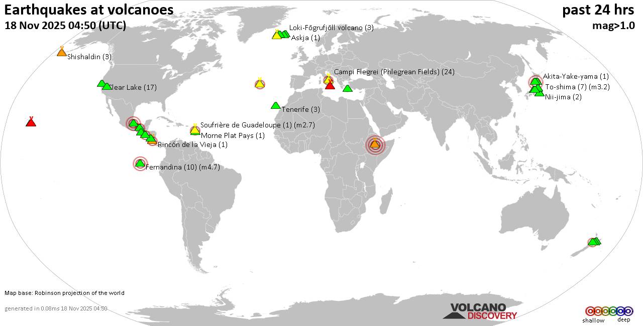 World map showing volcanoes with shallow (less than 50 km) earthquakes within 20 km radius during the past 24 hours on 18 Nov 2025 Number in brackets indicate nr of quakes. Quakes detected near: Akagi (3 quakes between mag 0.5-1.6), Akuseki-jima (1 quake mag 1.8), Barva (1 quake mag 1.7), Campi Flegrei (Phlegrean Fields) (19 quakes between mag 0.1-1.8), Clear Lake (16 quakes between mag 0.6-1.2), Cleveland (1 quake mag 2.1)
Coso (3 quakes between mag 0.8-1.1), Daisen (3 quakes between mag 0.3-1.2), El Chichón (4 quakes between mag 1.9-2.7), El Hierro (1 quake mag 1.9), Eldey (47 quakes between mag 0.2-2.0), Erciyes Dagi (2 quakes between mag 1.2-1.6), Etna (2 quakes between mag 1.3-1.6), Fagradalsfjall (2 quakes between mag 0.7-1.1), Fernandina (2 quakes between mag 3.1-3.9), Hakone (1 quake mag 2.1), Hiuchi (7 quakes between mag 0.2-1.0), Hrómundartindur (8 quakes between mag 0.4-1.1), Kilauea (4 quakes between mag 1.7-1.8), Kolumbo (4 quakes between mag 1.5-2.0), Krísuvík (9 quakes between mag 0.1-1.1), Ljósufjöll (5 quakes between mag 0.2-2.6), Loihi (1 quake mag 1.7), Loki-Fögrufjöll volcano (3 quakes between mag 0.6-1.7), Mammoth Mountain (1 quake mag 1.2), Mauna Kea (1 quake mag 1.9), Maunaloa (1 quake mag 2.1), Mount St. Helens (5 quakes between mag 0.2-1.2), Nejapa-Miraflores (1 quake mag 3.0), Nii-jima (1 quake mag 1.7), Niigata-Yake-yama (1 quake mag 3.0), Prestahnukur (1 quake mag 1.4), Santorini (1 quake mag 1.3), Shishaldin (2 quakes between mag 0.9-1.3), Taupo (1 quake mag 2.2), Tenerife (1 quake mag 1.2), Terceira (3 quakes between mag 2.0-2.3), Tjörnes Fracture Zone (1 quake mag 1.1), Towada (1 quake mag 1.7), Veniaminof (2 quakes between mag 0.2-1.3), Washiba-Kumonotaira (5 quakes between mag 0.2-2.1) (updated 23h50)
Note: Earthquakes within 20 km from and at depths less than 50 km under active volcanoes are reported. The list is not complete because many volcanoes are not monitored and/or seismic data in high resolution is not available publicly.
Volcanoes with recent earthquakes above magnitude 2 or more than 10 quakes are listed below:
Campi Flegrei (Phlegrean Fields) volcano (Italy): 19 earthquakes up to magnitude 1.8Possible earthquake swarm: 19 earthquakes occurred near (under) the volcano during 16 hours, the last being recorded quake 8 hours ago. Hypocenter depths ranged between 3.43 and 0.21 km. Earthquake details: (only 5 largest) 1.8 quake 3.4 km west of Fuorigrotta, Napoli, Campania, Italy, Nov 18, 2025 06:05 am (GMT +1) (2 km E) 1.1 quake 4.1 km southeast of Pozzuoli, Napoli, Campania, Italy, Nov 18, 2025 07:00 am (GMT +1) (0 km SW) 1.1 quake 4.3 km west of Fuorigrotta, Napoli, Campania, Italy, Nov 18, 2025 02:35 am (GMT +1) (1 km ESE) 1.1 quake 12 km west of Naples, Napoli, Campania, Italy, Nov 18, 2025 11:53 am (GMT +1) (1 km NW) 1.0 quake 0.9 km west of Bagnoli, Napoli, Campania, Italy, Nov 18, 2025 12:53 am (GMT +1) (3 km SE) All earthquakes at Campi Flegrei (Phlegrean Fields)Clear Lake volcano (California): 16 earthquakes up to magnitude 1.2Possible earthquake swarm: 16 earthquakes occurred near (under) the volcano during 21 hours, the last being recorded quake 1 hour 21 minutes ago. Hypocenter depths ranged between 3.85 and 0.70 km. Earthquake details: (only 5 largest) 1.2 quake Lake County, 28 mi north of Santa Rosa, Sonoma County, California, United States, Nov 17, 2025 07:37 pm (GMT -8) (15 km S) 1.0 quake 25 mi north of Santa Rosa, Sonoma County, California, United States, Nov 18, 2025 07:42 am (GMT -8) (19 km S) 1.0 quake 26 mi north of Santa Rosa, Sonoma County, California, United States, Nov 18, 2025 05:15 am (GMT -8) (18 km SSW) 1.0 quake 26 mi north of Santa Rosa, Sonoma County, California, United States, Nov 18, 2025 03:28 am (GMT -8) (17 km S) 1.0 quake 28 mi north of Santa Rosa, Sonoma County, California, United States, Nov 17, 2025 06:30 pm (GMT -8) (16 km SSW) All earthquakes at Clear LakeCleveland volcano (Aleutian Islands): magnitude 2.1 earthquakeA magnitude 2.1 earthquake occurred at the volcano 23 hours ago. The quake, which might be volcanic in origin, was located at a depth of 3.02 km depth at 5 km distance ESE from the volcano. Earthquake details: 2.1 quake Bering Sea, 3.9 mi southwest of Chuginadak Island, Aleutians West Census Area, Alaska, United States, Nov 17, 2025 02:52 pm (GMT -10) (5 km ESE) All earthquakes at ClevelandEl Chichón volcano (Southern Mexico): 4 earthquakes up to magnitude 2.74 earthquakes occurred near (under) the volcano during 10 hours, the last being recorded quake 13 hours ago. Hypocenter depths ranged between 5.40 and 2.80 km. Earthquake details: 2.7 quake Estado de Chiapas, 37 km southwest of Teapa, Estado de Tabasco, Mexico, Nov 17, 2025 07:02 pm (GMT -6) (1 km W) 2.5 quake Estado de Chiapas, 36 km southwest of Teapa, Estado de Tabasco, Mexico, Nov 17, 2025 07:47 pm (GMT -6) (0 km WNW) 2.1 quake Estado de Chiapas, 36 km southwest of Teapa, Estado de Tabasco, Mexico, Nov 18, 2025 03:09 am (GMT -6) (1 km SSE) 1.9 quake Estado de Chiapas, 37 km southwest of Teapa, Estado de Tabasco, Mexico, Nov 18, 2025 04:39 am (GMT -6) (1 km SSW) All earthquakes at El ChichónEldey volcano (Iceland): 47 earthquakes up to magnitude 2.0Possible earthquake swarm: 47 earthquakes occurred near (under) the volcano during 19 hours, the last being recorded quake 17 minutes ago. Hypocenter depths ranged between 12.40 and 1.10 km. Earthquake details: (only 5 largest) 2.0 quake Iceland: 7.2 km W of Reykjanestá Nov 18, 2025 11:14 pm (Reykjavik time) (10 km NE) 1.7 quake Iceland: 7.2 km NE of Eldey Nov 18, 2025 10:29 pm (Reykjavik time) (9 km NE) 1.6 quake Iceland: 7.3 km NE of Eldey Nov 18, 2025 11:25 pm (Reykjavik time) (9 km NE) 1.6 quake Iceland: 7.0 km WSW of Reykjanestá Nov 18, 2025 11:29 pm (Reykjavik time) (10 km NE) 1.6 quake Iceland: 7.2 km W of Reykjanestá Nov 18, 2025 10:05 pm (Reykjavik time) (10 km NE) All earthquakes at EldeyEldey is located at the beginning of the Reykjanes Ridge off the SW tip of Iceland. Its highest elevation is the top of Eldey Island, but most of the volcanic edifice is submerged. Several eruptions occurred in historic times, last in 1926. Fernandina volcano (Galapagos Islands): 2 earthquakes up to magnitude 3.92 earthquakes occurred near (under) the volcano during 14 hours, the last being recorded quake 10 hours ago. Hypocenter depths ranged between 1.00 and 0.00 km. Earthquake details: 3.9 quake 94 km northwest of Puerto Villamil, Provincia de Galapagos, Ecuador, Nov 17, 2025 07:02 pm (GMT -5) (3 km N) 3.1 quake 93 km northwest of Puerto Villamil, Provincia de Galapagos, Ecuador, Nov 18, 2025 07:52 am (GMT -6) (4 km NNE) All earthquakes at FernandinaHakone volcano (Honshu): magnitude 2.1 earthquakeA magnitude 2.1 earthquake occurred at the volcano 13 hours ago. The quake, which might be volcanic in origin, was located at a depth of 8.80 km depth at 17 km distance NNE from the volcano. Earthquake details: 2.1 quake 13 km west of Hadano, Kanagawa, Japan, Nov 18, 2025 08:18 pm (GMT +9) (17 km NNE) All earthquakes at HakoneLjósufjöll volcano (Iceland): 5 earthquakes up to magnitude 2.65 earthquakes occurred near (under) the volcano during 19 hours, the last being recorded quake 3 hours ago. Hypocenter depths ranged between 18.10 and 13.10 km. Earthquake details: 2.6 quake 27.5 km N of Borgarnes Nov 18, 2025 04:31 am (Universal Time) (16 km ESE) 1.1 quake Iceland: 27.9 km N of Borgarnes Nov 18, 2025 08:59 pm (Reykjavik time) (18 km ESE) 0.8 quake Iceland: 27.7 km N of Borgarnes Nov 18, 2025 03:38 am (Reykjavik time) (15 km ESE) 0.4 quake Iceland: 28.2 km N of Borgarnes Nov 18, 2025 03:40 am (Reykjavik time) (15 km ESE) 0.2 quake Iceland: 28.4 km N of Borgarnes Nov 18, 2025 01:40 am (Reykjavik time) (14 km ESE) All earthquakes at LjósufjöllMaunaloa volcano (Hawai'i (Big Island)): magnitude 2.1 earthquakeA magnitude 2.1 earthquake occurred at the volcano 37 minutes ago. The quake, which might be volcanic in origin, was located at a depth of 5.94 km depth at 17 km distance SE from the volcano. Earthquake details: 2.1 quake 11 mi north of Pāhala, Hawaii County, Hawaii, United States, Nov 18, 2025 01:13 pm (GMT -10) (17 km SE) All earthquakes at MaunaloaNejapa-Miraflores volcano (Nicaragua): magnitude 3.0 earthquakeA magnitude 3.0 earthquake occurred at the volcano 24 hours ago. The quake, which might be volcanic in origin, was located at a depth of 10.00 km depth at 6 km distance NNW from the volcano. Earthquake details: Reported seismic-like event (likely no quake): 10.8 km west of Managua, Departamento de Managua, Nicaragua, Nov 17, 2025 05:55 pm (GMT -6) (6 km NNW) All earthquakes at Nejapa-MirafloresNiigata-Yake-yama volcano (Honshu): magnitude 3.0 earthquakeA magnitude 3.0 earthquake occurred at the volcano 8 hours ago. The quake, which might be volcanic in origin, was located at a depth of 10.00 km depth at 12 km distance NNW from the volcano. Earthquake details: Reported seismic-like event (likely no quake): 25 km southwest of Joetsu, Niigata, Japan, Nov 19, 2025 12:59 am (GMT +9) (12 km NNW) All earthquakes at Niigata-Yake-yamaTaupo volcano (New Zealand): magnitude 2.2 earthquakeA magnitude 2.2 earthquake occurred at the volcano 3 hours ago. The quake, which might be volcanic in origin, was located at a depth of 6.30 km depth at 19 km distance NNE from the volcano. Earthquake details: 2.2 quake 2.1 km north of Taupo, Waikato, New Zealand, Nov 19, 2025 09:41 am (GMT +13) (19 km NNE) All earthquakes at TaupoTerceira volcano (Azores): 3 earthquakes up to magnitude 2.33 earthquakes occurred near (under) the volcano during 6 hours, the last being recorded quake 18 hours ago. Hypocenter depths ranged between 3.30 and 0.60 km. Earthquake details: 2.3 quake 15 km northwest of Angra do Heroismo, Azores, Portugal, Nov 17, 2025 10:55 pm (GMT -1) (3 km NNW) 2.2 quake 12 km northwest of Angra do Heroismo, Azores, Portugal, Nov 18, 2025 04:27 am (GMT -1) (3 km ENE) 2.0 quake 12 km northwest of Angra do Heroismo, Azores, Portugal, Nov 17, 2025 11:28 pm (GMT -1) (2 km ENE) All earthquakes at TerceiraUnnamed 52.92°N/158.52°E volcano (Southern Kamchatka): magnitude 3.0 earthquakeA magnitude 3.0 earthquake occurred at the volcano 9 hours ago. The quake, which might be volcanic in origin, was located at a depth of 10.00 km depth at 17 km distance NNE from the volcano. Earthquake details: Reported seismic-like event (likely no quake): 1.9 km southeast of Petropavlovsk-Kamchatskiy, Kamchatka, Russia, Nov 19, 2025 02:30 am (GMT +12) (17 km NNE) All earthquakes at Unnamed 52.92°N/158.52°EWashiba-Kumonotaira volcano (Honshu): 5 earthquakes up to magnitude 2.15 earthquakes occurred near (under) the volcano during 1 hour 38 minutes, the last being recorded quake 19 hours ago. Hypocenter depths ranged between 4.70 and 2.30 km. Earthquake details: 2.1 quake Gifu, 34 km northwest of Matsumoto, Nagano, Japan, Nov 18, 2025 12:56 pm (GMT +9) (7 km SSE) 0.7 quake 33 km northwest of Matsumoto, Nagano, Japan, Nov 18, 2025 01:04 pm (GMT +9) (6 km SSE) 0.6 quake 34 km northwest of Matsumoto, Nagano, Japan, Nov 18, 2025 02:15 pm (GMT +9) (6 km SSE) 0.3 quake 34 km northwest of Matsumoto, Nagano, Japan, Nov 18, 2025 12:37 pm (GMT +9) (6 km SSE) 0.2 quake 34 km northwest of Matsumoto, Nagano, Japan, Nov 18, 2025 01:14 pm (GMT +9) (6 km SSE) All earthquakes at Washiba-Kumonotairahttps://www.volcanodiscovery.com/earthquakes-volcanoes/news/287152/Volcano-earthquake-report-for-Tuesday-18-Nov-2025.html
|
|


CMS The Best Conveyancing solicitors conveyancing quotes throughout the UK
For any webhosting enquiries please email webmaster@aus-city.com
|
|
Forums60
Topics758,988
Posts793,702
Members2,958
| |
Most Online17,963
Jan 15th, 2026
|
|
|
|
|
Copyright 1996 - 2026 by David Cottle. Designed by David Bate Jr. All Rights Reserved.
By using this forum, the user agrees not to transfer any data or technical information received under the agreement, to any other entity without the express approval of the AUS-CITY Forum Admins and/or authors of individual posts (Forum Admins and DoD/USSPACECOM for the analysis of satellite tracking data).
Two-line elements (TLE) and all other satellite data presented and distributed via this forum and e-mail lists of AUS-CITY are distributed with permission from DoD/USSTRATCOM.

Reprise Hosting

|

|


 - Click image for larger picture.")


