|
|
|
0 members (),
1,447
guests, and
24
robots. |
|
Key:
Admin,
Global Mod,
Mod
|
|
S |
M |
T |
W |
T |
F |
S |
|
|
|
|
|
|
1
|
2
|
|
3
|
4
|
5
|
6
|
7
|
8
|
9
|
|
10
|
11
|
12
|
13
|
14
|
15
|
16
|
|
17
|
18
|
19
|
20
|
21
|
22
|
23
|
|
24
|
25
|
26
|
27
|
28
|
29
|
30
|
|
31
|
|
|
|
|
|
|
|
There are no members with birthdays on this day. |

World Earthquake Report for Monday, 25 May 2026
• Moderate mag. 4.1 earthquake - 80 km northwest of Galela, Kabupaten Halmahe...
• Moderate magnitude 4.5 quake hits 102 km northeast of Manokwari, Indonesia ...
• Volcano earthquake report for Monday, 25 May 2026
• Moderate mag. 4.8 earthquake - South Pacific Ocean, 89 km northeast of Mano...
• Moderate mag. 4.0 earthquake - South Pacific Ocean, 81 km southwest of Moll...
|

#792502
Mon 12 Jan 2026 08:50:PM
|
Joined: Feb 2001
Posts: 381,904
Launch Director
|
OP

Launch Director
Joined: Feb 2001
Posts: 381,904 |
Volcano earthquake report for Monday, 12 Jan 2026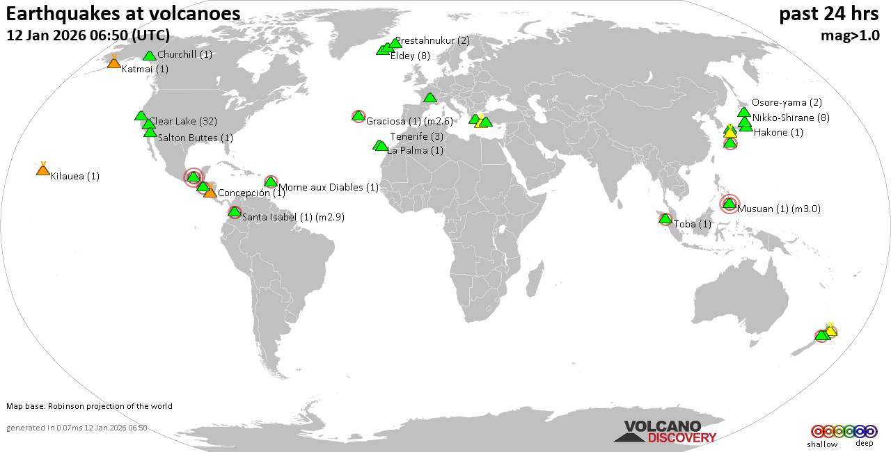 World map showing volcanoes with shallow (less than 50 km) earthquakes within 20 km radius during the past 24 hours on 12 Jan 2026 Number in brackets indicate nr of quakes. Quakes detected near: Abu (11 quakes between mag 0.5-1.1), Akagi (1 quake mag 1.6), Akuseki-jima (2 quakes between mag 1.3-1.9), Akyarlar (2 quakes between mag 1.6-1.9), Apastepeque (1 quake mag 2.5), Aso (11 quakes between mag 0.2-1.0)
Cabalian (1 quake mag 1.8), Chaîne des Puys (1 quake mag 1.3), Churchill (1 quake mag 1.6), Clear Lake (31 quakes between mag 0.2-2.1), Concepción (1 quake mag 1.8), Cuernos de Negros (1 quake mag 3.0), Daisen (1 quake mag 1.4), El Chichón (8 quakes between mag 2.3-3.1), Graciosa (1 quake mag 2.6), Grímsvötn (1 quake mag 1.1), Irazu (1 quake mag 3.0), Kalatungan (1 quake mag 2.4), Katla (2 quakes between mag 1.0-1.1), Kirishima (4 quakes between mag 0.3-1.9), Loihi (1 quake mag 1.7), Madeira (1 quake mag 3.0), Morne Watt (1 quake mag 1.3), Nikko-Shirane (8 quakes between mag 0.1-1.6), Pocdol Mountains (1 quake mag 2.3), Prestahnukur (3 quakes between mag 0.7-1.5), Rotorua (1 quake mag 3.0), Sanbe (2 quakes between mag 0.6-1.3), Sandal (1 quake mag 1.0), Sousaki (4 quakes between mag 1.6-2.0), Talakmau (1 quake mag 2.5), Tenerife (7 quakes between mag 0.7-1.2), Tjörnes Fracture Zone (2 quakes between mag 0.9-1.3), Whale Island (1 quake mag 2.3) (updated 20h50)
Note: Earthquakes within 20 km from and at depths less than 50 km under active volcanoes are reported. The list is not complete because many volcanoes are not monitored and/or seismic data in high resolution is not available publicly.
Volcanoes with recent earthquakes above magnitude 2 or more than 10 quakes are listed below:
Abu volcano (Honshu): 11 earthquakes up to magnitude 1.1Possible earthquake swarm: 11 earthquakes occurred near (under) the volcano during 15 hours, the last being recorded quake 5 hours ago. Hypocenter depths ranged between 31.60 and 28.70 km. Earthquake details: (only 5 largest) 1.1 quake 30 km north of Yamaguchi, Yamaguchi, Japan, Jan 12, 2026 02:13 pm (GMT +9) (8 km SSW) 1.0 quake 30 km north of Yamaguchi, Yamaguchi, Japan, Jan 12, 2026 11:25 am (GMT +9) (8 km S) 1.0 quake 29 km north of Yamaguchi, Yamaguchi, Japan, Jan 12, 2026 02:25 pm (GMT +9) (8 km S) 1.0 quake 30 km north of Yamaguchi, Yamaguchi, Japan, Jan 12, 2026 09:20 am (GMT +9) (8 km SSW) 0.9 quake 29 km northeast of Yamaguchi, Yamaguchi, Japan, Jan 12, 2026 04:49 pm (GMT +9) (9 km S) All earthquakes at AbuApastepeque volcano (El Salvador): magnitude 2.5 earthquakeA magnitude 2.5 earthquake occurred at the volcano 16 hours ago. The quake, which might be volcanic in origin, was located at a depth of 9.00 km depth at 9 km distance SSE from the volcano. Earthquake details: 2.5 quake 4.3 km east of San Vicente, Departamento de San Vicente, El Salvador, Jan 11, 2026 11:16 pm (GMT -6) (9 km SSE) All earthquakes at ApastepequeAso volcano (Kyushu): 11 earthquakes up to magnitude 1.0Possible earthquake swarm: 11 earthquakes occurred near (under) the volcano during 19 hours, the last being recorded quake 4 hours ago. Hypocenter depths ranged between 9.30 and 5.60 km. Earthquake details: (only 5 largest) 1.0 quake 6.6 km north of Aso, Kumamoto, Japan, Jan 12, 2026 10:39 am (GMT +9) (13 km N) 0.9 quake 6.7 km northeast of Aso, Kumamoto, Japan, Jan 12, 2026 11:34 am (GMT +9) (12 km N) 0.9 quake 3.9 km northeast of Aso, Kumamoto, Japan, Jan 12, 2026 08:48 am (GMT +9) (10 km N) 0.7 quake 47 km northeast of Kumamoto, Kumamoto, Japan, Jan 12, 2026 07:08 pm (GMT +9) (14 km N) 0.7 quake 45 km northeast of Kumamoto, Kumamoto, Japan, Jan 12, 2026 06:37 am (GMT +9) (13 km N) All earthquakes at AsoClear Lake volcano (California): 31 earthquakes up to magnitude 2.1Possible earthquake swarm: 31 earthquakes occurred near (under) the volcano during 23 hours, the last being recorded quake 19 minutes ago. Hypocenter depths ranged between 3.27 and 0.05 km. Earthquake details: (only 5 largest) 2.1 quake Sonoma County, 14 mi southwest of Clearlake, Lake County, California, United States, Jan 12, 2026 11:39 am (GMT -8) (16 km SSW) 1.7 quake Sonoma County, 13 mi southwest of Clearlake, Lake County, California, United States, Jan 11, 2026 04:40 pm (GMT -8) (17 km S) 1.6 quake 29 mi north of Santa Rosa, Sonoma County, California, United States, Jan 11, 2026 03:36 pm (GMT -8) (17 km SSW) 1.3 quake 27 mi north of Santa Rosa, Sonoma County, California, United States, Jan 12, 2026 06:03 am (GMT -8) (16 km SSW) 1.3 quake 28 mi north of Santa Rosa, Sonoma County, California, United States, Jan 11, 2026 05:05 pm (GMT -8) (16 km SSW) All earthquakes at Clear LakeCuernos de Negros volcano (Central Philippines): magnitude 3.0 earthquakeA magnitude 3.0 earthquake occurred at the volcano 7 hours ago. The quake, which might be volcanic in origin, was located at a depth of 10.00 km depth at 10 km distance SE from the volcano. Earthquake details: Reported seismic-like event (likely no quake): 15 km southwest of Dumaguete, Philippines, Jan 12, 2026 09:42 pm (GMT +8) (10 km SE) All earthquakes at Cuernos de NegrosEl Chichón volcano (Southern Mexico): 8 earthquakes up to magnitude 3.18 earthquakes occurred near (under) the volcano during 8 hours, the last being recorded quake 11 hours ago. Hypocenter depths ranged between 3.00 and 2.30 km. Earthquake details: (only 5 largest) 3.1 quake Estado de Chiapas, 36 km southwest of Teapa, Estado de Tabasco, Mexico, Jan 12, 2026 12:00 am (GMT -6) (1 km NNE) 2.8 quake Estado de Chiapas, 38 km southwest of Teapa, Estado de Tabasco, Mexico, Jan 11, 2026 11:09 pm (GMT -6) (1 km SW) 2.5 quake Estado de Chiapas, 37 km southwest of Teapa, Estado de Tabasco, Mexico, Jan 11, 2026 07:24 pm (GMT -6) (1 km WNW) 2.5 quake Estado de Chiapas, 37 km southwest of Teapa, Estado de Tabasco, Mexico, Jan 12, 2026 01:48 am (GMT -6) (2 km NNW) 2.4 quake Estado de Chiapas, 37 km southwest of Teapa, Estado de Tabasco, Mexico, Jan 11, 2026 09:49 pm (GMT -6) (2 km NW) All earthquakes at El ChichónGraciosa volcano (Azores): magnitude 2.6 earthquakeA magnitude 2.6 earthquake occurred at the volcano 22 hours ago. The quake, which might be volcanic in origin, was located at a depth of 4.50 km depth at 9 km distance WNW from the volcano. Earthquake details: 2.6 quake 6 km southwest of Santa Cruz da Graciosa, Azores, Portugal, Jan 11, 2026 09:29 pm (GMT -1) (9 km WNW) All earthquakes at GraciosaIrazu volcano (Costa Rica): magnitude 3.0 earthquakeA magnitude 3.0 earthquake occurred at the volcano 12 hours ago. The quake, which might be volcanic in origin, was located at a depth of 10.00 km depth at 8 km distance SE from the volcano. Earthquake details: Reported seismic-like event (likely no quake): 13 km northeast of Paraiso, Provincia de Cartago, Costa Rica, Jan 12, 2026 03:14 am (GMT -6) (8 km SE) All earthquakes at IrazuKalatungan volcano (Mindanao): magnitude 2.4 earthquakeA magnitude 2.4 earthquake occurred at the volcano 6 hours ago. The quake, which might be volcanic in origin, was located at a depth of 6.00 km depth at 17 km distance SW from the volcano. Earthquake details: 2.4 quake 37 km west of Maramag, Province of Bukidnon, Northern Mindanao, Philippines, Jan 12, 2026 10:48 pm (GMT +8) (17 km SW) All earthquakes at KalatunganMadeira volcano (Madeira): magnitude 3.0 earthquakeA magnitude 3.0 earthquake occurred at the volcano 11 hours ago. The quake, which might be volcanic in origin, was located at a depth of 10.00 km depth at 14 km distance W from the volcano. Earthquake details: Reported seismic-like event (likely no quake): 23 km west of Funchal, Madeira, Portugal, Jan 12, 2026 09:44 am (GMT +0) (14 km W) All earthquakes at MadeiraPocdol Mountains volcano (Luzon Island): magnitude 2.3 earthquakeA magnitude 2.3 earthquake occurred at the volcano 28 minutes ago. The quake, which might be volcanic in origin, was located at a depth of 17.00 km depth at 9 km distance WNW from the volcano. Earthquake details: 2.3 quake 17 km southeast of Legaspi, Province of Albay, Bicol, Philippines, Jan 13, 2026 04:22 am (GMT +8) (9 km WNW) All earthquakes at Pocdol MountainsRotorua volcano (New Zealand): magnitude 3.0 earthquakeA magnitude 3.0 earthquake occurred at the volcano 14 hours ago. The quake, which might be volcanic in origin, was located at a depth of 10.00 km depth at 7 km distance SSE from the volcano. Earthquake details: Reported quake or seismic-like event: 5.4 km east of Rotorua, Bay of Plenty, New Zealand, Jan 12, 2026 07:56 pm (GMT +13) (7 km SSE) All earthquakes at RotoruaTalakmau volcano (Sumatra): magnitude 2.5 earthquakeA magnitude 2.5 earthquake occurred at the volcano 2 hours ago. The quake, which might be volcanic in origin, was located at a depth of 24.00 km depth at 6 km distance SSW from the volcano. Earthquake details: 2.5 quake Kabupaten Pasaman Barat, 58 km northwest of Bukittinggi, Indonesia, Jan 13, 2026 01:46 am (GMT +7) (6 km SSW) All earthquakes at TalakmauWhale Island volcano (New Zealand): magnitude 2.3 earthquakeA magnitude 2.3 earthquake occurred at the volcano 19 hours ago. The quake, which might be volcanic in origin, was located at a depth of 31.70 km depth at 9 km distance SSE from the volcano. Earthquake details: 2.3 quake South Pacific Ocean, 4.6 km northeast of Whakatane, Bay of Plenty, New Zealand, Jan 12, 2026 03:06 pm (GMT +13) (9 km SSE) All earthquakes at Whale Islandhttps://www.volcanodiscovery.com/earthquakes-volcanoes/news/291728/Volcano-earthquake-report-for-Monday-12-Jan-2026.html
|
|


CMS The Best Conveyancing solicitors conveyancing quotes throughout the UK
For any webhosting enquiries please email webmaster@aus-city.com
|
|
Forums60
Topics776,784
Posts811,581
Members2,960
| |
Most Online22,463
May 9th, 2026
|
|
|
|
|
Copyright 1996 - 2026 by David Cottle. Designed by David Bate Jr. All Rights Reserved.
By using this forum, the user agrees not to transfer any data or technical information received under this agreement to any other entity without the express approval of the AUS-CITY Forum Admins and/or authors of individual posts (Forum Admins and DoD/USSPACECOM for the analysis of satellite tracking data).
Two-line elements (TLE) and all other satellite data presented and distributed via this forum and AUS-CITY mailing lists are distributed with permission from DoD/USSTRATCOM.

|

|


 - Click image for larger picture.")


