|
|
|
0 members (),
3,139
guests, and
25
robots. |
|
Key:
Admin,
Global Mod,
Mod
|
|
S |
M |
T |
W |
T |
F |
S |
|
|
|
|
|
1
|
2
|
3
|
|
4
|
5
|
6
|
7
|
8
|
9
|
10
|
|
11
|
12
|
13
|
14
|
15
|
16
|
17
|
|
18
|
19
|
20
|
21
|
22
|
23
|
24
|
|
25
|
26
|
27
|
28
|
29
|
30
|
31
|
|
There are no members with birthdays on this day. |

#795246
Sat 24 Jan 2026 11:50:PM
|
Joined: Feb 2001
Posts: 381,904
Launch Director
|
OP

Launch Director
Joined: Feb 2001
Posts: 381,904 |
Volcano earthquake report for Saturday, 24 Jan 2026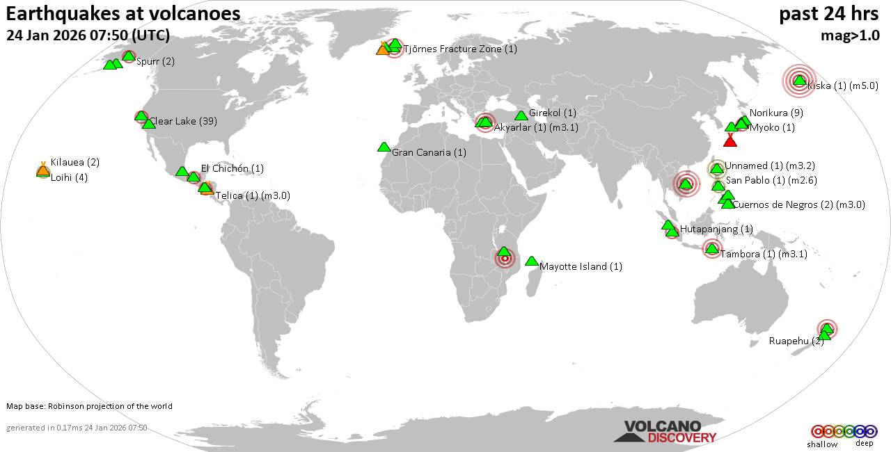 World map showing volcanoes with shallow (less than 50 km) earthquakes within 20 km radius during the past 24 hours on 24 Jan 2026 Number in brackets indicate nr of quakes. Quakes detected near: Ankaratra Field (1 quake mag 4.8), Aso (12 quakes between mag 0.4-2.6), Auckland Field (1 quake mag 3.0), Bardarbunga (5 quakes between mag 0.7-2.3), Biliran (2 quakes between mag 1.5-2.5), Clear Lake (32 quakes between mag 0.2-2.4)
Denison (1 quake mag 1.5), Hiuchi (3 quakes between mag 0.3-1.1), Hrómundartindur (3 quakes between mag 0.3-1.1), Hutapanjang (1 quake mag 2.9), Katla (1 quake mag 2.0), Kilauea (2 quakes between mag 2.2-2.2), Kirishima (2 quakes between mag 0.5-1.3), Kolumbo (4 quakes between mag 1.1-1.7), Komaga-take (5 quakes between mag 0.4-2.3), Laacher See (1 quake mag 3.0), Laguna Aramuaca (1 quake mag 2.5), Ljósufjöll (13 quakes between mag 0.9-2.9), Loihi (5 quakes between mag 1.7-2.3), Long Valley (1 quake mag 1.4), Machin (3 quakes between mag 1.0-2.9), Makushin (1 quake mag 3.9), Mayotte Island (1 quake mag 1.1), Megata (1 quake mag 1.4), Methana (1 quake mag 1.2), Mt Fuji (1 quake mag 3.0), Nevado del Ruiz (1 quake mag 1.0), Ontake-san (4 quakes between mag 0.2-1.8), Osore-yama (3 quakes between mag 0.4-2.1), Santorini (1 quake mag 1.7), Sousaki (1 quake mag 2.1), Spurr (2 quakes between mag 1.8-2.4), Tenerife (3 quakes between mag 0.7-1.2), Thordarhyrna (11 quakes between mag 1.0-2.8), Towada (1 quake mag 3.0), Tupungatito (1 quake mag 2.6), Washiba-Kumonotaira (11 quakes between mag 0.1-1.4) (updated 23h50)
Note: Earthquakes within 20 km from and at depths less than 50 km under active volcanoes are reported. The list is not complete because many volcanoes are not monitored and/or seismic data in high resolution is not available publicly.
Volcanoes with recent earthquakes above magnitude 2 or more than 10 quakes are listed below:
Ankaratra Field volcano (Madagascar): magnitude 4.8 earthquakeA magnitude 4.8 earthquake occurred at the volcano 15 hours ago. The quake, which might be volcanic in origin, was located at a depth of 10.00 km depth at 13 km distance WNW from the volcano. Earthquake details: 4.8 quake Bongolava Region, 93 km southwest of Antananarivo, Analamanga Region, Madagascar, Jan 24, 2026 11:32 am (GMT +3) (13 km WNW) All earthquakes at Ankaratra FieldAso volcano (Kyushu): 12 earthquakes up to magnitude 2.6Possible earthquake swarm: 12 earthquakes occurred near (under) the volcano during 18 hours, the last being recorded quake 1 hour 22 minutes ago. Hypocenter depths ranged between 11.00 and 6.00 km. Earthquake details: (only 5 largest) 2.6 quake 5.2 km northeast of Aso, Kumamoto, Japan, Jan 25, 2026 12:25 am (GMT +9) (11 km N) 2.2 quake 6.2 km north of Aso, Kumamoto, Japan, Jan 25, 2026 12:27 am (GMT +9) (12 km N) 2.2 quake 3.2 km northeast of Aso, Kumamoto, Japan, Jan 25, 2026 12:20 am (GMT +9) (9 km N) 2.1 quake 5.2 km northeast of Aso, Kumamoto, Japan, Jan 25, 2026 12:31 am (GMT +9) (11 km N) 1.4 quake 5.4 km northeast of Aso, Kumamoto, Japan, Jan 25, 2026 12:25 am (GMT +9) (11 km N) All earthquakes at AsoAuckland Field volcano (North Island): magnitude 3.0 earthquakeA magnitude 3.0 earthquake occurred at the volcano 21 hours ago. The quake, which might be volcanic in origin, was located at a depth of 10.00 km depth at 4 km distance N from the volcano. Earthquake details: Reported seismic-like event (likely no quake): 9.2 km east of Auckland, Auckland, New Zealand, Jan 24, 2026 03:47 pm (GMT +13) (4 km N) All earthquakes at Auckland FieldBardarbunga volcano (Iceland): 5 earthquakes up to magnitude 2.35 earthquakes occurred near (under) the volcano during 8 hours, the last being recorded quake 15 hours ago. Hypocenter depths ranged between 10.70 and 1.10 km. Earthquake details: 2.3 quake 7.3 km E of Bárðarbunga Jan 24, 2026 09:00 am (Universal Time) (7 km E) 1.0 quake 7.1 km E of Bárðarbunga Jan 24, 2026 12:56 am (Universal Time) (7 km E) 0.8 quake Iceland: 5.9 km E of Bárðarbunga Jan 24, 2026 05:18 am (Reykjavik time) (6 km E) 0.8 quake Iceland: 6.8 km ESE of Bárðarbunga Jan 24, 2026 06:42 am (Reykjavik time) (7 km E) 0.7 quake Iceland: 9.4 km ESE of Bárðarbunga Jan 24, 2026 06:48 am (Reykjavik time) (9 km ESE) All earthquakes at BardarbungaBiliran volcano (Central Philippines): 2 earthquakes up to magnitude 2.52 earthquakes occurred near (under) the volcano during 60 seconds, the last being recorded quake 14 hours ago. Hypocenter depths ranged between 28.00 and 5.00 km. Earthquake details: 2.5 quake 23 km northwest of Carigara, Province of Leyte, Eastern Visayas, Philippines, Jan 24, 2026 06:14 pm (GMT +8) (12 km SSW) 1.5 quake Province of Leyte, Eastern Visayas, 49 km northeast of Daanbantayan, Philippines, Jan 24, 2026 06:13 pm (GMT +8) (16 km WSW) All earthquakes at BiliranClear Lake volcano (California): 32 earthquakes up to magnitude 2.4Possible earthquake swarm: 32 earthquakes occurred near (under) the volcano during 20 hours, the last being recorded quake 1 hour 51 minutes ago. Hypocenter depths ranged between 2.83 and 0.23 km. Earthquake details: (only 5 largest) 2.4 quake 13 mi southwest of Clearlake, Lake County, California, United States, Jan 23, 2026 05:51 pm (GMT -8) (15 km S) 1.5 quake Sonoma County, 13 mi southwest of Clearlake, Lake County, California, United States, Jan 23, 2026 06:28 pm (GMT -8) (15 km S) 1.5 quake 25 mi north of Santa Rosa, Sonoma County, California, United States, Jan 23, 2026 08:25 pm (GMT -8) (19 km S) 1.3 quake 29 mi north of Santa Rosa, Sonoma County, California, United States, Jan 23, 2026 07:24 pm (GMT -8) (17 km SSW) 1.3 quake Lake County, 28 mi north of Santa Rosa, Sonoma County, California, United States, Jan 23, 2026 09:50 pm (GMT -8) (15 km S) All earthquakes at Clear LakeHutapanjang volcano (Sumatra): magnitude 2.9 earthquakeA magnitude 2.9 earthquake occurred at the volcano 19 hours ago. The quake, which might be volcanic in origin, was located at a depth of 14.00 km depth at 11 km distance NW from the volcano. Earthquake details: 2.9 quake Kabupaten Kerinci, 28 km southeast of Sungai Penuh, Indonesia, Jan 24, 2026 11:42 am (GMT +7) (11 km NW) All earthquakes at HutapanjangKilauea volcano (Hawai'i (Big Island)): 2 earthquakes up to magnitude 2.22 earthquakes occurred near (under) the volcano during 16 hours, the last being recorded quake 48 minutes ago. Hypocenter depths ranged between 31.96 and 28.44 km. Earthquake details: 2.2 quake 31 mi south of Hilo, Hawaii County, Hawaii, United States, Jan 24, 2026 01:02 pm (GMT -10) (10 km S) 2.2 quake 7 mi northeast of Pāhala, Hawaii County, Hawaii, United States, Jan 23, 2026 09:23 pm (GMT -10) (19 km SW) All earthquakes at KilaueaKomaga-take volcano (Hokkaido): 5 earthquakes up to magnitude 2.35 earthquakes occurred near (under) the volcano during 15 hours, the last being recorded quake 3 hours ago. Hypocenter depths ranged between 10.50 and 8.00 km. Earthquake details: 2.3 quake 31 km north of Hakodate, Hokkaido, Japan, Jan 24, 2026 03:23 pm (GMT +9) (8 km E) 0.7 quake 28 km north of Hakodate, Hokkaido, Japan, Jan 25, 2026 05:51 am (GMT +9) (10 km ESE) 0.6 quake 28 km north of Hakodate, Hokkaido, Japan, Jan 24, 2026 06:11 pm (GMT +9) (10 km ESE) 0.5 quake 29 km north of Hakodate, Hokkaido, Japan, Jan 24, 2026 08:58 pm (GMT +9) (10 km ESE) 0.4 quake 28 km north of Hakodate, Hokkaido, Japan, Jan 24, 2026 03:04 pm (GMT +9) (10 km ESE) All earthquakes at Komaga-takeLaacher See volcano (Germany): magnitude 3.0 earthquakeA magnitude 3.0 earthquake occurred at the volcano 14 hours ago. The quake, which might be volcanic in origin, was located at a depth of 10.00 km depth at 5 km distance SE from the volcano. Earthquake details: Reported seismic-like event (likely no quake): 18 km west of Koblenz, Kreisfreie Stadt Pirmasens, Rheinland-Pfalz, Germany, Jan 24, 2026 11:19 am (GMT +1) (5 km SE) All earthquakes at Laacher SeeLaguna Aramuaca volcano (El Salvador): magnitude 2.5 earthquakeA magnitude 2.5 earthquake occurred at the volcano 19 hours ago. The quake, which might be volcanic in origin, was located at a depth of 7.00 km depth at 17 km distance SE from the volcano. Earthquake details: 2.5 quake 15 km west of La Union, Departamento de La Union, El Salvador, Jan 23, 2026 10:39 pm (GMT -6) (17 km SE) All earthquakes at Laguna AramuacaLjósufjöll volcano (Iceland): 13 earthquakes up to magnitude 2.9Possible earthquake swarm: 13 earthquakes occurred near (under) the volcano during 4 hours, the last being recorded quake 12 hours ago. Hypocenter depths ranged between 18.00 and 14.40 km. Earthquake details: (only 5 largest) 2.9 quake West, 73 km north of Reykjavik, Capital Region, Iceland, Jan 24, 2026 08:05 am (Reykjavik time) (17 km ESE) 2.5 quake 27.7 km N of Borgarnes Jan 24, 2026 08:33 am (Universal Time) (16 km ESE) 1.7 quake 28.2 km N of Borgarnes Jan 24, 2026 11:34 am (Universal Time) (16 km ESE) 1.3 quake 27.0 km N of Borgarnes Jan 24, 2026 08:16 am (Universal Time) (16 km ESE) 1.2 quake Iceland: 28.5 km N of Borgarnes Jan 24, 2026 10:38 am (Reykjavik time) (16 km ESE) All earthquakes at LjósufjöllLoihi volcano (Hawai'i (Big Island)): 5 earthquakes up to magnitude 2.35 earthquakes occurred near (under) the volcano during 7 hours, the last being recorded quake 10 hours ago. Hypocenter depths ranged between 42.58 and 28.64 km. Earthquake details: 2.3 quake North Pacific Ocean, 14 mi southeast of Pāhala, Hawaii County, Hawaii, United States, Jan 23, 2026 10:59 pm (GMT -10) (16 km NW) 2.1 quake North Pacific Ocean, 45 mi southeast of of Hawai‘i Island, Hawaii County, Hawaii, United States, Jan 24, 2026 01:01 am (GMT -10) (12 km WNW) 1.8 quake North Pacific Ocean, 42 mi southeast of of Hawai‘i Island, Hawaii County, Hawaii, United States, Jan 24, 2026 04:09 am (GMT -10) (18 km WNW) 1.8 quake North Pacific Ocean, 42 mi southeast of of Hawai‘i Island, Hawaii County, Hawaii, United States, Jan 23, 2026 10:55 pm (GMT -10) (15 km NW) 1.7 quake North Pacific Ocean, 42 mi southeast of of Hawai‘i Island, Hawaii County, Hawaii, United States, Jan 23, 2026 08:56 pm (GMT -10) (14 km NW) All earthquakes at LoihiMachin volcano (Colombia): 3 earthquakes up to magnitude 2.93 earthquakes occurred near (under) the volcano during 9 minutes, the last being recorded quake 12 hours ago. Hypocenter depths ranged between 8.00 and 1.00 km. Earthquake details: 2.9 quake 9.8 km northeast of Anaime, Departamento de Tolima, Colombia, Jan 24, 2026 07:10 am (GMT -5) (3 km SSE) 2.9 quake 20 km west of Ibague, Departamento de Tolima, Colombia, Jan 24, 2026 07:10 am (GMT -5) (3 km SSE) 1.0 quake 26 km west of Ibague, Departamento de Tolima, Colombia, Jan 24, 2026 07:01 am (GMT -5) (5 km NW) All earthquakes at MachinMakushin volcano (Aleutian Islands): magnitude 3.9 earthquakeA magnitude 3.9 earthquake occurred at the volcano 7 hours ago. The quake, which might be volcanic in origin, was located at a depth of 8.40 km depth at 13 km distance S from the volcano. Earthquake details: 3.9 quake Bering Sea, 58 mi south of Unalaska Island, Aleutians West Census Area, Alaska, United States, Jan 24, 2026 07:50 am (GMT -9) (13 km S) All earthquakes at MakushinMt Fuji volcano (Honshu): magnitude 3.0 earthquakeA magnitude 3.0 earthquake occurred at the volcano 8 hours ago. The quake, which might be volcanic in origin, was located at a depth of 10.00 km depth at 16 km distance NE from the volcano. Earthquake details: Reported seismic-like event (likely no quake): 36 km southeast of Kofu, Yamanashi, Japan, Jan 25, 2026 01:10 am (GMT +9) (16 km NE) All earthquakes at Mt FujiOsore-yama volcano (Honshu): 3 earthquakes up to magnitude 2.13 earthquakes occurred near (under) the volcano during 14 hours, the last being recorded quake 4 hours ago. Hypocenter depths ranged between 11.40 and 8.60 km. Earthquake details: 2.1 quake 8.5 km south of Ninohe, Iwate, Japan, Jan 25, 2026 04:00 am (GMT +9) (17 km ESE) 1.0 quake 12 km south of Ninohe, Iwate, Japan, Jan 24, 2026 02:21 pm (GMT +9) (17 km SE) 0.4 quake 8.3 km south of Ninohe, Iwate, Japan, Jan 25, 2026 04:33 am (GMT +9) (17 km ESE) All earthquakes at Osore-yamaSousaki volcano (Greece): magnitude 2.1 earthquakeA magnitude 2.1 earthquake occurred at the volcano 4 hours ago. The quake, which might be volcanic in origin, was located at a depth of 10.00 km depth at 9 km distance S from the volcano. Earthquake details: 2.1 quake Aegean Sea, 16 km southeast of Corinth, Nomos Korinthias, Peloponnese, Greece, Jan 24, 2026 10:03 pm (GMT +2) (9 km S) All earthquakes at SousakiSpurr volcano (Cook Inlet (SW Alaska)): 2 earthquakes up to magnitude 2.42 earthquakes occurred near (under) the volcano during 2 hours, the last being recorded quake 18 hours ago. Hypocenter depths ranged between 13.70 and 5.00 km. Earthquake details: 2.4 quake Kenai Peninsula Borough, 78 mi west of Anchorage, Anchorage Municipality, Alaska, United States, Jan 23, 2026 09:03 pm (GMT -9) (1 km SSE) 1.8 quake Kenai Peninsula Borough, 81 mi west of Anchorage, Anchorage Municipality, Alaska, United States, Jan 23, 2026 06:46 pm (GMT -9) (9 km SSW) All earthquakes at SpurrThordarhyrna volcano (Iceland): 11 earthquakes up to magnitude 2.8Possible earthquake swarm: 11 earthquakes occurred near (under) the volcano during 1 hour 35 minutes, the last being recorded quake 12 hours ago. Hypocenter depths ranged between 3.10 and 2.00 km. Earthquake details: (only 5 largest) 2.8 quake South, 208 km east of Reykjavik, Capital Region, Iceland, Jan 24, 2026 11:59 am (Reykjavik time) (1 km E) 2.4 quake 21.7 km SW of Grímsfjall Jan 24, 2026 11:09 am (Universal Time) (1 km E) 1.5 quake 22.3 km SW of Grímsfjall Jan 24, 2026 11:14 am (Universal Time) (0 km ESE) 1.5 quake 22.3 km SW of Grímsfjall Jan 24, 2026 11:05 am (Universal Time) (0 km E) 1.4 quake 22.4 km SW of Grímsfjall Jan 24, 2026 10:35 am (Universal Time) (1 km ESE) All earthquakes at ThordarhyrnaTowada volcano (Honshu): magnitude 3.0 earthquakeA magnitude 3.0 earthquake occurred at the volcano 14 hours ago. The quake, which might be volcanic in origin, was located at a depth of 10.00 km depth at 9 km distance NNW from the volcano. Earthquake details: Reported seismic-like event (likely no quake): 28 km west of Towada, Aomori, Japan, Jan 24, 2026 07:15 pm (GMT +9) (9 km NNW) All earthquakes at TowadaTupungatito volcano (Central Chile and Argentina): magnitude 2.6 earthquakeA magnitude 2.6 earthquake occurred at the volcano 4 hours ago. The quake, which might be volcanic in origin, was located at a depth of 11.60 km depth at 7 km distance WNW from the volcano. Earthquake details: 2.6 quake Cordillera, 73 km east of Santiago, Santiago, Santiago Metropolitan, Chile, Jan 24, 2026 05:19 pm (GMT -3) (7 km WNW) All earthquakes at TupungatitoWashiba-Kumonotaira volcano (Honshu): 11 earthquakes up to magnitude 1.4Possible earthquake swarm: 11 earthquakes occurred near (under) the volcano during 22 hours, the last being recorded quake 1 hour 9 minutes ago. Hypocenter depths ranged between 6.20 and 0.00 km. Earthquake details: (only 5 largest) 1.4 quake 25 km west of Azumino, Nagano, Japan, Jan 25, 2026 12:25 am (GMT +9) (5 km SSE) 1.2 quake 24 km west of Azumino, Nagano, Japan, Jan 25, 2026 07:41 am (GMT +9) (8 km SSE) 0.8 quake 25 km west of Azumino, Nagano, Japan, Jan 25, 2026 04:47 am (GMT +9) (5 km SSE) 0.7 quake 24 km west of Azumino, Nagano, Japan, Jan 25, 2026 06:05 am (GMT +9) (6 km SE) 0.5 quake 25 km west of Azumino, Nagano, Japan, Jan 25, 2026 06:57 am (GMT +9) (6 km SSE) All earthquakes at Washiba-Kumonotairahttps://www.volcanodiscovery.com/earthquakes-volcanoes/news/292777/Volcano-earthquake-report-for-Saturday-24-Jan-2026.html
|
|


CMS The Best Conveyancing solicitors conveyancing quotes throughout the UK
For any webhosting enquiries please email webmaster@aus-city.com
|
|
Forums60
Topics758,807
Posts793,521
Members2,958
| |
Most Online17,963
Jan 15th, 2026
|
|
|
|
|
Copyright 1996 - 2026 by David Cottle. Designed by David Bate Jr. All Rights Reserved.
By using this forum, the user agrees not to transfer any data or technical information received under the agreement, to any other entity without the express approval of the AUS-CITY Forum Admins and/or authors of individual posts (Forum Admins and DoD/USSPACECOM for the analysis of satellite tracking data).
Two-line elements (TLE) and all other satellite data presented and distributed via this forum and e-mail lists of AUS-CITY are distributed with permission from DoD/USSTRATCOM.

Reprise Hosting

|

|


 - Click image for larger picture.")


