|
|
|
0 members (),
2,504
guests, and
30
robots. |
|
Key:
Admin,
Global Mod,
Mod
|
|
S |
M |
T |
W |
T |
F |
S |
|
1
|
2
|
3
|
4
|
5
|
6
|
7
|
|
8
|
9
|
10
|
11
|
12
|
13
|
14
|
|
15
|
16
|
17
|
18
|
19
|
20
|
21
|
|
22
|
23
|
24
|
25
|
26
|
27
|
28
|
|
There are no members with birthdays on this day. |
|
|
Joined: Feb 2001
Posts: 381,904
Launch Director
|
OP

Launch Director
Joined: Feb 2001
Posts: 381,904 |
Volcano earthquake report for Monday, 2 Feb 2026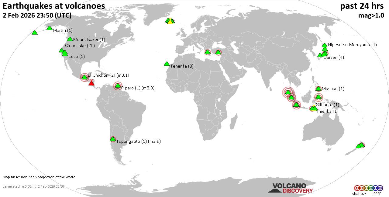 World map showing volcanoes with shallow (less than 50 km) earthquakes within 20 km radius during the past 24 hours on 2 Feb 2026 Number in brackets indicate nr of quakes. Quakes detected near: Akita-Yake-yama (2 quakes between mag 0.7-1.3), Akutan (2 quakes between mag 0.3-1.5), Bardarbunga (3 quakes between mag 0.4-1.9), Clear Lake (20 quakes between mag 0.3-1.4), Coso (5 quakes between mag 0.5-1.8), Daisen (4 quakes between mag 0.9-1.5)
El Chichón (2 quakes between mag 2.8-3.1), Geureudong (4 quakes between mag 2.1-4.1), Gilbanta (1 quake mag 2.3), Hiuchi (6 quakes between mag 0.5-2.4), Hulubelu (1 quake mag 3.3), Inielika (1 quake mag 2.2), Karapinar (1 quake mag 2.0), Katla (3 quakes between mag 0.7-2.5), Ljósufjöll (5 quakes between mag 0.2-1.1), Loki-Fögrufjöll volcano (2 quakes between mag 0.4-1.4), Long Valley (23 quakes between mag 0.7-2.4), Martin (1 quake mag 1.3), Masaya (1 quake mag 1.6), Mount Baker (1 quake mag 1.3), Musuan (1 quake mag 2.0), Nipesotsu-Maruyama (1 quake mag 1.1), Okataina (Tarawera) (1 quake mag 2.4), Ontake-san (4 quakes between mag 0.1-1.2), Osore-yama (1 quake mag 1.0), Paluweh (1 quake mag 2.3), Piparo (1 quake mag 3.0), Prestahnukur (1 quake mag 1.3), Reporoa (1 quake mag 1.5), Soputan (1 quake mag 3.3), Sorikmarapi (1 quake mag 3.0), Sousaki (3 quakes between mag 1.4-2.2), Suoh (2 quakes between mag 2.2-3.9), Taranaki (1 quake mag 1.7), Tenerife (3 quakes between mag 1.1-1.2), Thordarhyrna (1 quake mag 1.3), Torfajökull (1 quake mag 1.2), Tupungatito (1 quake mag 2.9) (updated 23h50)
Note: Earthquakes within 20 km from and at depths less than 50 km under active volcanoes are reported. The list is not complete because many volcanoes are not monitored and/or seismic data in high resolution is not available publicly.
Volcanoes with recent earthquakes above magnitude 2 or more than 10 quakes are listed below:
Clear Lake volcano (California): 20 earthquakes up to magnitude 1.4Possible earthquake swarm: 20 earthquakes occurred near (under) the volcano during 23 hours, the last being recorded quake 29 minutes ago. Hypocenter depths ranged between 3.47 and 1.18 km. Earthquake details: (only 5 largest) 1.4 quake 28 mi north of Santa Rosa, Sonoma County, California, United States, Feb 2, 2026 11:57 am (GMT -8) (15 km SSW) 1.3 quake 26 mi north of Santa Rosa, Sonoma County, California, United States, Feb 2, 2026 05:43 am (GMT -8) (18 km SSW) 1.2 quake 25 mi north of Santa Rosa, Sonoma County, California, United States, Feb 2, 2026 10:13 am (GMT -8) (19 km S) 1.2 quake 27 mi north of Santa Rosa, Sonoma County, California, United States, Feb 1, 2026 10:54 pm (GMT -8) (16 km SSW) 1.0 quake 27 mi north of Santa Rosa, Sonoma County, California, United States, Feb 2, 2026 03:21 pm (GMT -8) (18 km SSW) All earthquakes at Clear LakeEl Chichón volcano (Southern Mexico): 2 earthquakes up to magnitude 3.12 earthquakes occurred near (under) the volcano during 28 minutes, the last being recorded quake 17 hours ago. Hypocenter depths ranged between 3.00 and 3.00 km. Earthquake details: 3.1 quake Estado de Chiapas, 38 km southwest of Teapa, Estado de Tabasco, Mexico, Feb 2, 2026 12:35 am (GMT -6) (1 km SSW) 2.8 quake Estado de Chiapas, 38 km southwest of Teapa, Estado de Tabasco, Mexico, Feb 2, 2026 01:03 am (GMT -6) (1 km SSW) All earthquakes at El ChichónGeureudong volcano (Sumatra): 4 earthquakes up to magnitude 4.14 earthquakes occurred near (under) the volcano during 12 hours, the last being recorded quake 1 hour 11 minutes ago. Hypocenter depths ranged between 10.00 and 7.00 km. Earthquake details: 4.1 quake Kabupaten Aceh Utara, 47 km southwest of Lhokseumawe, Indonesia, Feb 3, 2026 05:38 am (GMT +7) (17 km N) 2.2 quake Kabupaten Aceh Tengah, 66 km southwest of Lhokseumawe, Indonesia, Feb 2, 2026 06:05 pm (GMT +7) (7 km SSW) 2.2 quake Kabupaten Bener Meriah, 61 km southwest of Lhokseumawe, Indonesia, Feb 2, 2026 05:16 pm (GMT +7) (3 km SSW) 2.1 quake Kabupaten Bener Meriah, 54 km south of Bireun, Indonesia, Feb 2, 2026 11:51 pm (GMT +7) (5 km SSW) All earthquakes at GeureudongGilbanta volcano (Lesser Sunda Islands): magnitude 2.3 earthquakeA magnitude 2.3 earthquake occurred at the volcano 21 hours ago. The quake, which might be volcanic in origin, was located at a depth of 6.00 km depth at 18 km distance N from the volcano. Earthquake details: 2.3 quake Flores Sea, 19 km north of Gili Banta Island, West Nusa Tenggara, Indonesia, Feb 2, 2026 11:08 am (GMT +8) (18 km N) All earthquakes at GilbantaHiuchi volcano (Honshu): 6 earthquakes up to magnitude 2.46 earthquakes occurred near (under) the volcano during 17 hours, the last being recorded quake 6 hours ago. Hypocenter depths ranged between 10.20 and 3.70 km. Earthquake details: (only 5 largest) 2.4 quake Fukushima, 32 km northwest of Nikko, Tochigi, Japan, Feb 2, 2026 02:14 pm (GMT +9) (10 km ENE) 1.2 quake Fukushima, 32 km northwest of Nikko, Tochigi, Japan, Feb 2, 2026 11:03 pm (GMT +9) (10 km ENE) 0.9 quake Fukushima, 31 km northwest of Nikko, Tochigi, Japan, Feb 2, 2026 08:45 pm (GMT +9) (10 km E) 0.8 quake Fukushima, 32 km northwest of Nikko, Tochigi, Japan, Feb 3, 2026 02:25 am (GMT +9) (9 km ENE) 0.7 quake Fukushima, 36 km east of Minamiuonuma, Niigata, Japan, Feb 2, 2026 01:10 pm (GMT +9) (16 km N) All earthquakes at HiuchiHulubelu volcano (Sumatra): magnitude 3.3 earthquakeA magnitude 3.3 earthquake occurred at the volcano 1 hour 44 minutes ago. The quake, which might be volcanic in origin, was located at a depth of 5.00 km depth at 18 km distance W from the volcano. Earthquake details: 3.3 quake Kabupaten Tanggamus, 94 km west of Bandar Lampung, Indonesia, Feb 3, 2026 05:06 am (GMT +7) (18 km W) All earthquakes at HulubeluInielika volcano (Flores): magnitude 2.2 earthquakeA magnitude 2.2 earthquake occurred at the volcano 11 hours ago. The quake, which might be volcanic in origin, was located at a depth of 10.00 km depth at 5 km distance SSW from the volcano. Earthquake details: 2.2 quake Kabupaten Ngada, 57 km east of Ruteng, Indonesia, Feb 2, 2026 08:28 pm (GMT +8) (5 km SSW) All earthquakes at InielikaKatla volcano (Iceland): 3 earthquakes up to magnitude 2.53 earthquakes occurred near (under) the volcano during 11 hours, the last being recorded quake 12 hours ago. Hypocenter depths ranged between 11.70 and 1.00 km. Earthquake details: 2.5 quake 3.4 km NNW of Hábunga Feb 2, 2026 11:22 am (Universal Time) (4 km SW) 1.1 quake 3.5 km NE of Hábunga Feb 2, 2026 12:17 am (Universal Time) (3 km S) 0.7 quake Iceland: 4.5 km NW of Hábunga Feb 2, 2026 11:24 am (Reykjavik time) (5 km WSW) All earthquakes at KatlaLong Valley volcano (California): 23 earthquakes up to magnitude 2.4Possible earthquake swarm: 23 earthquakes occurred near (under) the volcano during 15 hours, the last being recorded quake 7 hours ago. Hypocenter depths ranged between 8.34 and 2.30 km. Earthquake details: (only 5 largest) 2.4 quake 7 mi east of Mammoth Lakes, Mono County, California, United States, Feb 2, 2026 02:14 am (GMT -8) (7 km SSE) 1.8 quake 7.1 mi east of Mammoth Lakes, Mono County, California, United States, Feb 2, 2026 02:19 am (GMT -8) (6 km SSE) 1.7 quake 7.7 mi east of Mammoth Lakes, Mono County, California, United States, Feb 2, 2026 02:46 am (GMT -8) (7 km SSE) 1.5 quake 7.1 mi east of Mammoth Lakes, Mono County, California, United States, Feb 2, 2026 02:49 am (GMT -8) (7 km SSE) 1.5 quake 7.2 mi east of Mammoth Lakes, Mono County, California, United States, Feb 2, 2026 02:25 am (GMT -8) (7 km SSE) All earthquakes at Long ValleyOkataina (Tarawera) volcano (New Zealand): magnitude 2.4 earthquakeA magnitude 2.4 earthquake occurred at the volcano 14 hours ago. The quake, which might be volcanic in origin, was located at a depth of 5.90 km depth at 13 km distance SSW from the volcano. Earthquake details: 2.4 quake 21 km southeast of Rotorua, Bay of Plenty, New Zealand, Feb 2, 2026 11:10 pm (GMT +13) (13 km SSW) All earthquakes at Okataina (Tarawera)Paluweh volcano (Lesser Sunda Islands): magnitude 2.3 earthquakeA magnitude 2.3 earthquake occurred at the volcano 50 minutes ago. The quake, which might be volcanic in origin, was located at a depth of 17.00 km depth at 12 km distance ESE from the volcano. Earthquake details: 2.3 quake Flores Sea, 53 km northwest of Maumere, Indonesia, Feb 3, 2026 07:00 am (GMT +8) (12 km ESE) All earthquakes at PaluwehPiparo volcano (Caribbean): magnitude 3.0 earthquakeA magnitude 3.0 earthquake occurred at the volcano 20 hours ago. The quake, which might be volcanic in origin, was located at a depth of 10.00 km depth at 14 km distance SW from the volcano. Earthquake details: Reported seismic-like event (likely no quake): 28 km south of Chaguanas, Chaguanas, Trinidad and Tobago, Feb 1, 2026 11:47 pm (GMT -4) (14 km SW) All earthquakes at PiparoSoputan volcano (Sulawesi & Sangihe Islands): magnitude 3.3 earthquakeA magnitude 3.3 earthquake occurred at the volcano 10 hours ago. The quake, which might be volcanic in origin, was located at a depth of 19.00 km depth at 17 km distance SE from the volcano. Earthquake details: 3.3 quake Kabupaten Minahasa Tenggara, 55 km south of Manado, Indonesia, Feb 2, 2026 10:02 pm (GMT +8) (17 km SE) All earthquakes at SoputanSorikmarapi volcano (Sumatra): magnitude 3.0 earthquakeA magnitude 3.0 earthquake occurred at the volcano 19 hours ago. The quake, which might be volcanic in origin, was located at a depth of 1.00 km depth at 5 km distance NE from the volcano. Earthquake details: 3.0 quake Kabupaten Mandailing Natal, 81 km southeast of Padangsidempuan, Indonesia, Feb 2, 2026 11:49 am (GMT +7) (5 km NE) All earthquakes at SorikmarapiSousaki volcano (Greece): 3 earthquakes up to magnitude 2.23 earthquakes occurred near (under) the volcano during 14 hours, the last being recorded quake 9 hours ago. Hypocenter depths ranged between 12.50 and 5.00 km. Earthquake details: 2.2 quake 16 km south of Corinth, Nomos Korinthias, Peloponnese, Greece, Feb 2, 2026 02:42 am (GMT +2) (18 km SSW) 1.5 quake 18 km south of Corinth, Nomos Korinthias, Peloponnese, Greece, Feb 2, 2026 04:44 pm (GMT +2) (19 km SSW) 1.4 quake Aegean Sea, 11 km southeast of Corinth, Nomos Korinthias, Peloponnese, Greece, Feb 2, 2026 03:20 pm (GMT +2) (12 km SW) All earthquakes at SousakiSuoh volcano (Sumatra): 2 earthquakes up to magnitude 3.92 earthquakes occurred near (under) the volcano during 48 minutes, the last being recorded quake 1 hour 24 minutes ago. Hypocenter depths ranged between 7.00 and 3.00 km. Earthquake details: 3.9 quake Kabupaten Tanggamus, 94 km west of Bandar Lampung, Indonesia, Feb 3, 2026 04:37 am (GMT +7) (17 km ESE) 2.2 quake Kabupaten Tanggamus, 94 km west of Bandar Lampung, Indonesia, Feb 3, 2026 05:25 am (GMT +7) (17 km ESE) All earthquakes at Suoh Tupungatito volcano (Central Chile and Argentina): magnitude 2.9 earthquakeA magnitude 2.9 earthquake occurred at the volcano 23 hours ago. The quake, which might be volcanic in origin, was located at a depth of 3.70 km depth at 6 km distance W from the volcano. Earthquake details: 2.9 quake Cordillera, 74 km east of Santiago, Santiago, Santiago Metropolitan, Chile, Feb 1, 2026 10:02 pm (GMT -3) (6 km W) All earthquakes at Tupungatitohttps://www.volcanodiscovery.com/earthquakes-volcanoes/news/293649/Volcano-earthquake-report-for-Monday-2-Feb-2026.html
|
|


CMS The Best Conveyancing solicitors conveyancing quotes throughout the UK
For any webhosting enquiries please email webmaster@aus-city.com
|
|
Forums60
Topics760,169
Posts794,889
Members2,957
| |
Most Online17,963
Jan 15th, 2026
|
|
|
|
|
Copyright 1996 - 2026 by David Cottle. Designed by David Bate Jr. All Rights Reserved.
By using this forum, the user agrees not to transfer any data or technical information received under the agreement, to any other entity without the express approval of the AUS-CITY Forum Admins and/or authors of individual posts (Forum Admins and DoD/USSPACECOM for the analysis of satellite tracking data).
Two-line elements (TLE) and all other satellite data presented and distributed via this forum and e-mail lists of AUS-CITY are distributed with permission from DoD/USSTRATCOM.

Reprise Hosting

|

|


 - Click image for larger picture.")


