|
|
|
0 members (),
1,656
guests, and
19
robots. |
|
Key:
Admin,
Global Mod,
Mod
|
|
S |
M |
T |
W |
T |
F |
S |
|
|
|
|
1
|
2
|
3
|
4
|
|
5
|
6
|
7
|
8
|
9
|
10
|
11
|
|
12
|
13
|
14
|
15
|
16
|
17
|
18
|
|
19
|
20
|
21
|
22
|
23
|
24
|
25
|
|
26
|
27
|
28
|
29
|
30
|
31
|
|
|
There are no members with birthdays on this day. |

Volcano earthquake report for Saturday, 25 Jul 2026
• Moderate mag. 4.1 earthquake - North Pacific Ocean, 167 km southwest of Ret...
• Moderate mag. 4.1 earthquake - North Pacific Ocean, 167 km southwest of Ret...
• Moderate mag. 4.0 earthquake - South Pacific Ocean, 58 km west of Vallenar,...
• Moderate mag. 4.0 earthquake - South Pacific Ocean, 58 km west of Vallenar,...
|

#798025
Thu 12 Feb 2026 11:50:PM
|
Joined: Feb 2001
Posts: 678,976
Launch Director
|
OP

Launch Director
Joined: Feb 2001
Posts: 678,976 |
Volcano earthquake report for Thursday, 12 Feb 2026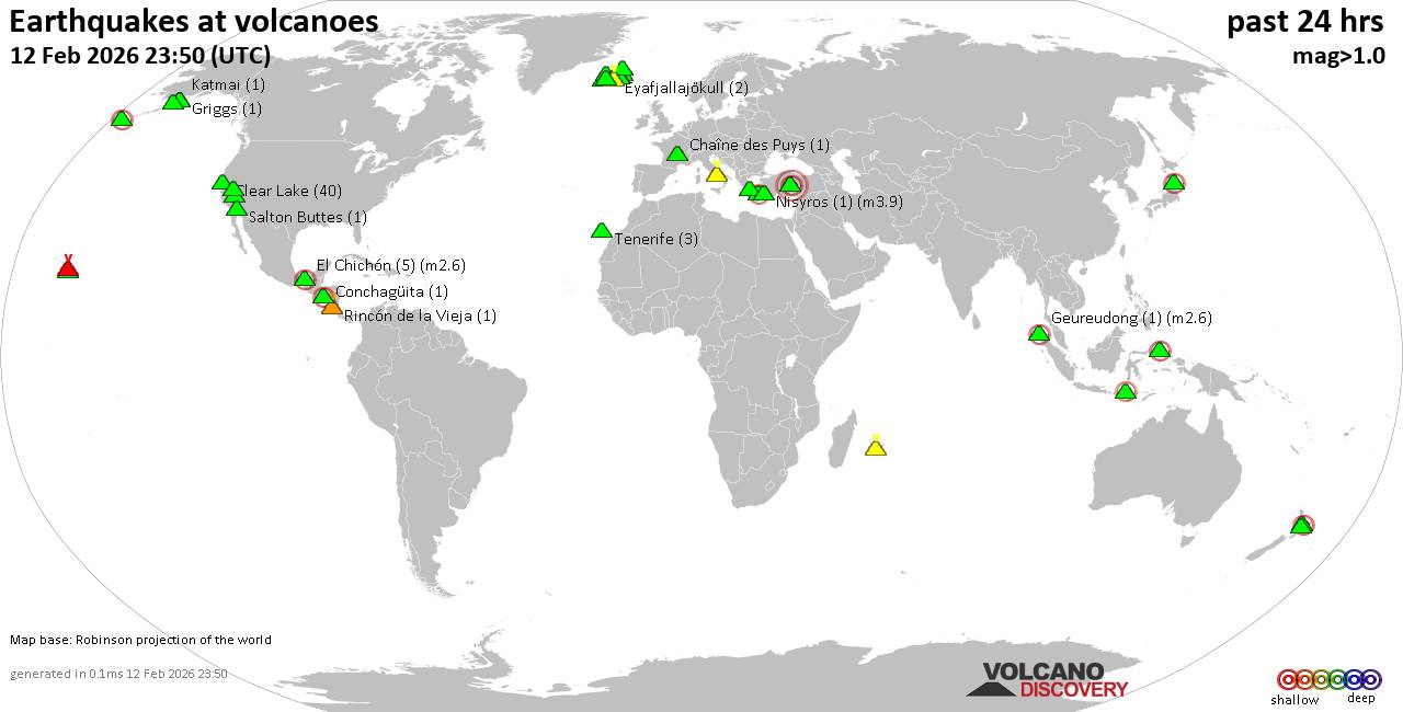 World map showing volcanoes with shallow (less than 50 km) earthquakes within 20 km radius during the past 24 hours on 12 Feb 2026 Number in brackets indicate nr of quakes. Quakes detected near: Acigöl-Nevsehir (1 quake mag 3.0), Askja (6 quakes between mag 0.0-1.8), Brennisteinsfjöll (1 quake mag 1.0), Campi Flegrei (Phlegrean Fields) (1 quake mag 1.7), Chaîne des Puys (1 quake mag 1.7), Clear Lake (40 quakes between mag 0.2-1.8)
Conchagüita (1 quake mag 2.5), Coso (7 quakes between mag 0.9-1.7), El Chichón (5 quakes between mag 1.7-2.6), Eldey (3 quakes between mag 0.9-1.2), Eyafjallajökull (2 quakes between mag 0.9-1.4), Geureudong (1 quake mag 2.6), Griggs (1 quake mag 1.2), Jailolo (1 quake mag 2.3), Katla (6 quakes between mag 0.0-3.2), Katmai (1 quake mag 1.1), Kilauea (4 quakes between mag 1.5-1.8), Kolumbo (1 quake mag 2.1), Kurikoma (1 quake mag 2.9), Ljósufjöll (4 quakes between mag 0.2-1.6), Loihi (7 quakes between mag 1.8-2.4), Loki-Fögrufjöll volcano (2 quakes between mag 1.0-2.8), Long Valley (2 quakes between mag 1.7-2.0), Maroa (2 quakes between mag 2.0-2.8), Methana (1 quake mag 2.1), Nisyros (1 quake mag 3.9), Piton de la Fournaise (5 quakes between mag 0.4-1.8), Rincón de la Vieja (1 quake mag 1.4), Salton Buttes (1 quake mag 1.2), Sangeang Api (1 quake mag 2.4), Taupo (1 quake mag 1.7), Tenerife (3 quakes between mag 0.7-1.9), Thordarhyrna (2 quakes between mag 0.0-1.8), Tindfjallajökull (2 quakes between mag 0.4-1.3), Tjörnes Fracture Zone (4 quakes between mag 0.2-1.4), Ugashik-Peulik (1 quake mag 1.2), Wide Bay (1 quake mag 2.1) (updated 23h50)
Note: Earthquakes within 20 km from and at depths less than 50 km under active volcanoes are reported. The list is not complete because many volcanoes are not monitored and/or seismic data in high resolution is not available publicly.
Volcanoes with recent earthquakes above magnitude 2 or more than 10 quakes are listed below:
Acigöl-Nevsehir volcano (Turkey): magnitude 3.0 earthquakeA magnitude 3.0 earthquake occurred at the volcano 15 hours ago. The quake, which might be volcanic in origin, was located at a depth of 10.00 km depth at 19 km distance ESE from the volcano. Earthquake details: Reported seismic-like event (likely no quake): 17 km south of Nevsehir, Nevsehir, Turkey, Feb 12, 2026 12:16 pm (GMT +3) (19 km ESE) All earthquakes at Acigöl-NevsehirClear Lake volcano (California): 40 earthquakes up to magnitude 1.8Possible earthquake swarm: 40 earthquakes occurred near (under) the volcano during 24 hours, the last being recorded quake 14 minutes ago. Hypocenter depths ranged between 3.74 and 0.02 km. Earthquake details: (only 5 largest) 1.8 quake Sonoma County, 13 mi southwest of Clearlake, Lake County, California, United States, Feb 12, 2026 10:51 am (GMT -8) (16 km SSW) 1.7 quake 13 mi southwest of Clearlake, Lake County, California, United States, Feb 11, 2026 11:07 pm (GMT -8) (19 km S) 1.5 quake 12 mi southwest of Clearlake, Lake County, California, United States, Feb 11, 2026 11:18 pm (GMT -8) (17 km S) 1.5 quake 26 mi north of Santa Rosa, Sonoma County, California, United States, Feb 11, 2026 10:57 pm (GMT -8) (18 km S) 1.3 quake 26 mi north of Santa Rosa, Sonoma County, California, United States, Feb 11, 2026 10:50 pm (GMT -8) (17 km S) All earthquakes at Clear LakeConchagüita volcano (El Salvador): magnitude 2.5 earthquakeA magnitude 2.5 earthquake occurred at the volcano 13 hours ago. The quake, which might be volcanic in origin, was located at a depth of 4.00 km depth at 14 km distance WNW from the volcano. Earthquake details: 2.5 quake 5.8 km southwest of La Union, Departamento de La Union, El Salvador, Feb 12, 2026 04:48 am (GMT -6) (14 km WNW) All earthquakes at ConchagüitaEl Chichón volcano (Southern Mexico): 5 earthquakes up to magnitude 2.65 earthquakes occurred near (under) the volcano during 10 hours, the last being recorded quake 13 hours ago. Hypocenter depths ranged between 3.00 and 3.00 km. Earthquake details: 2.6 quake Estado de Chiapas, 36 km southwest of Teapa, Estado de Tabasco, Mexico, Feb 11, 2026 08:38 pm (GMT -6) (1 km N) 2.6 quake Estado de Chiapas, 40 km southwest of Teapa, Estado de Tabasco, Mexico, Feb 12, 2026 04:49 am (GMT -6) (6 km WNW) 2.4 quake Estado de Chiapas, 37 km southwest of Teapa, Estado de Tabasco, Mexico, Feb 11, 2026 06:57 pm (GMT -6) (1 km NNW) 2.2 quake Estado de Chiapas, 37 km southwest of Teapa, Estado de Tabasco, Mexico, Feb 11, 2026 06:49 pm (GMT -6) (1 km NNW) 1.7 quake 19 km southwest of Pichucalco, Estado de Chiapas, Mexico, Feb 12, 2026 02:43 am (GMT -6) (1 km N) All earthquakes at El ChichónGeureudong volcano (Sumatra): magnitude 2.6 earthquakeA magnitude 2.6 earthquake occurred at the volcano 11 hours ago. The quake, which might be volcanic in origin, was located at a depth of 4.00 km depth at 7 km distance WSW from the volcano. Earthquake details: 2.6 quake Kabupaten Bener Meriah, 65 km southwest of Lhokseumawe, Indonesia, Feb 12, 2026 07:47 pm (GMT +7) (7 km WSW) All earthquakes at GeureudongJailolo volcano (Halmahera): magnitude 2.3 earthquakeA magnitude 2.3 earthquake occurred at the volcano 21 hours ago. The quake, which might be volcanic in origin, was located at a depth of 3.00 km depth at 8 km distance ESE from the volcano. Earthquake details: 2.3 quake Kabupaten Halmahera Barat, 31 km north of Ternate, Indonesia, Feb 12, 2026 12:18 pm (GMT +9) (8 km ESE) All earthquakes at JailoloKatla volcano (Iceland): 6 earthquakes up to magnitude 3.26 earthquakes occurred near (under) the volcano during 23 hours, the last being recorded quake 23 minutes ago. Hypocenter depths ranged between 9.60 and 0.00 km. Earthquake details: (only 5 largest) 3.2 quake South, 149 km east of Reykjavik, Capital Region, Iceland, Feb 12, 2026 10:53 pm (Reykjavik time) (3 km SSW) 1.0 quake Iceland: 5.4 km NNE of Hábunga Feb 12, 2026 09:50 am (Reykjavik time) (1 km SSE) 0.9 quake 11.4 km NNE of Goðabunga Feb 12, 2026 12:38 am (Universal Time) (12 km NNW) 0.7 quake Iceland: 0.7 km NW of Hábunga Feb 12, 2026 07:12 am (Reykjavik time) (6 km SSW) 0.3 quake Iceland: 2.9 km ESE of Goðabunga Feb 12, 2026 11:26 pm (Reykjavik time) (7 km W) All earthquakes at KatlaKolumbo volcano (Greece): magnitude 2.1 earthquakeA magnitude 2.1 earthquake occurred at the volcano 19 hours ago. The quake, which might be volcanic in origin, was located at a depth of 18.90 km depth at 18 km distance NE from the volcano. Earthquake details: 2.1 quake Aegean Sea, 28 km southeast of Nisi Irakleia Island, Greece, Feb 12, 2026 06:22 am (GMT +2) (18 km NE) All earthquakes at KolumboKurikoma volcano (Honshu): magnitude 2.9 earthquakeA magnitude 2.9 earthquake occurred at the volcano 18 hours ago. The quake, which might be volcanic in origin, was located at a depth of 9.00 km depth at 14 km distance NE from the volcano. Earthquake details: 2.9 quake 26 km west of Oshu, Iwate, Japan, Feb 12, 2026 03:15 pm (GMT +9) (14 km NE) All earthquakes at KurikomaLoihi volcano (Hawai'i (Big Island)): 7 earthquakes up to magnitude 2.47 earthquakes occurred near (under) the volcano during 21 hours, the last being recorded quake 1 hour 46 minutes ago. Hypocenter depths ranged between 34.24 and 30.18 km. Earthquake details: (only 5 largest) 2.4 quake North Pacific Ocean, 12 mi southeast of Pāhala, Hawaii County, Hawaii, United States, Feb 11, 2026 08:37 pm (GMT -10) (19 km NNW) 2.0 quake North Pacific Ocean, 39 mi southeast of of Hawai‘i Island, Hawaii County, Hawaii, United States, Feb 12, 2026 10:27 am (GMT -10) (19 km NNW) 1.9 quake North Pacific Ocean, 39 mi southeast of of Hawai‘i Island, Hawaii County, Hawaii, United States, Feb 12, 2026 12:04 pm (GMT -10) (18 km NW) 1.8 quake North Pacific Ocean, 38 mi southeast of of Hawai‘i Island, Hawaii County, Hawaii, United States, Feb 12, 2026 10:54 am (GMT -10) (19 km NNW) 1.8 quake North Pacific Ocean, 38 mi southeast of of Hawai‘i Island, Hawaii County, Hawaii, United States, Feb 12, 2026 10:27 am (GMT -10) (19 km NNW) All earthquakes at LoihiLoki-Fögrufjöll volcano volcano (Iceland): 2 earthquakes up to magnitude 2.82 earthquakes occurred near (under) the volcano during 4 hours, the last being recorded quake 15 hours ago. Hypocenter depths ranged between 5.20 and 2.60 km. Earthquake details: 2.8 quake South, 206 km east of Reykjavik, Capital Region, Iceland, Feb 12, 2026 09:14 am (Reykjavik time) (5 km ENE) 1.0 quake 4.7 km E of Hamarinn Feb 12, 2026 04:46 am (Universal Time) (4 km E) All earthquakes at Loki-Fögrufjöll volcanoMaroa volcano (New Zealand): 2 earthquakes up to magnitude 2.82 earthquakes occurred near (under) the volcano during 119 seconds, the last being recorded quake 12 hours ago. Hypocenter depths ranged between 4.40 and 4.00 km. Earthquake details: 2.8 quake 26 km south of Rotorua, Bay of Plenty, New Zealand, Feb 13, 2026 01:13 am (GMT +13) (11 km NE) 2.0 quake 25 km south of Rotorua, Bay of Plenty, New Zealand, Feb 13, 2026 01:15 am (GMT +13) (12 km ENE) All earthquakes at MaroaMethana volcano (Greece): magnitude 2.1 earthquakeA magnitude 2.1 earthquake occurred at the volcano 7 hours ago. The quake, which might be volcanic in origin, was located at a depth of 14.74 km depth at 11 km distance N from the volcano. Earthquake details: 2.1 quake 45 km southwest of Athens, Nomarchia Athinas, Attica, Greece, Feb 12, 2026 06:27 pm (GMT +2) (11 km N) All earthquakes at MethanaNisyros volcano (Greece): magnitude 3.9 earthquakeA magnitude 3.9 earthquake occurred at the volcano 13 hours ago. The quake, which might be volcanic in origin, was located at a depth of 10.00 km depth at 18 km distance W from the volcano. Earthquake details: 3.9 quake Aegean Sea, 18 km west of Nisi Nisyros Island, Dodecanese, South Aegean, Greece, Feb 12, 2026 01:01 pm (GMT +2) (18 km W) All earthquakes at NisyrosSangeang Api volcano (Lesser Sunda Islands): magnitude 2.4 earthquakeA magnitude 2.4 earthquake occurred at the volcano 5 hours ago. The quake, which might be volcanic in origin, was located at a depth of 14.00 km depth at 17 km distance N from the volcano. Earthquake details: 2.4 quake Kabupaten Bima, 60 km northeast of Bima, Indonesia, Feb 13, 2026 02:38 am (GMT +8) (17 km N) All earthquakes at Sangeang ApiWide Bay volcano (Aleutian Islands): magnitude 2.1 earthquakeA magnitude 2.1 earthquake occurred at the volcano 19 hours ago. The quake, which might be volcanic in origin, was located at a depth of 8.43 km depth at 7 km distance S from the volcano. Earthquake details: 2.1 quake 3.3 mi west of Dutch Harbor, Aleutians West Census Area, Alaska, United States, Feb 11, 2026 07:26 pm (GMT -9) (7 km S) All earthquakes at Wide Bayhttps://www.volcanodiscovery.com/earthquakes-volcanoes/news/294597/Volcano-earthquake-report-for-Thursday-12-Feb-2026.html
|
|


CMS The Best Conveyancing solicitors conveyancing quotes throughout the UK
For any webhosting enquiries please email webmaster@aus-city.com
|
|
Forums60
Topics792,785
Posts827,567
Members2,960
| |
Most Online102,106
Jul 10th, 2026
|
|
|
|
|
Copyright 1996 - 2026 by David Cottle. Designed by David Bate Jr. All Rights Reserved.
By using this forum, the user agrees not to transfer any data or technical information received under this agreement to any other entity without the express approval of the AUS-CITY Forum Admins and/or authors of individual posts (Forum Admins and DoD/USSPACECOM for the analysis of satellite tracking data).
Two-line elements (TLE) and all other satellite data presented and distributed via this forum and AUS-CITY mailing lists are distributed with permission from DoD/USSTRATCOM.

|

|


 - Click image for larger picture.")


