|
|
|
0 members (),
1,133
guests, and
20
robots. |
|
Key:
Admin,
Global Mod,
Mod
|
|
S |
M |
T |
W |
T |
F |
S |
|
|
|
|
1
|
2
|
3
|
4
|
|
5
|
6
|
7
|
8
|
9
|
10
|
11
|
|
12
|
13
|
14
|
15
|
16
|
17
|
18
|
|
19
|
20
|
21
|
22
|
23
|
24
|
25
|
|
26
|
27
|
28
|
29
|
30
|
31
|
|
|
There are no members with birthdays on this day. |

World Earthquake Report for July 2026
• World Earthquake Report for Thursday, 2 July 2026
• Volcano earthquake report for Thursday, 2 Jul 2026
• Small magnitude 3.2 quake hits 31 km west of Bergen, Norway early evening
• Moderate mag. 4.0 earthquake - 44 km northwest of Ancud, Provincia de Chilo...
• Moderate mag. 4.7 earthquake - Philippine Sea, 50 km northwest of Yonaguni-...
|

#800597
Sat 28 Feb 2026 04:50:PM
|
Joined: Feb 2001
Posts: 678,976
Launch Director
|
OP

Launch Director
Joined: Feb 2001
Posts: 678,976 |
Volcano earthquake report for Saturday, 28 Feb 2026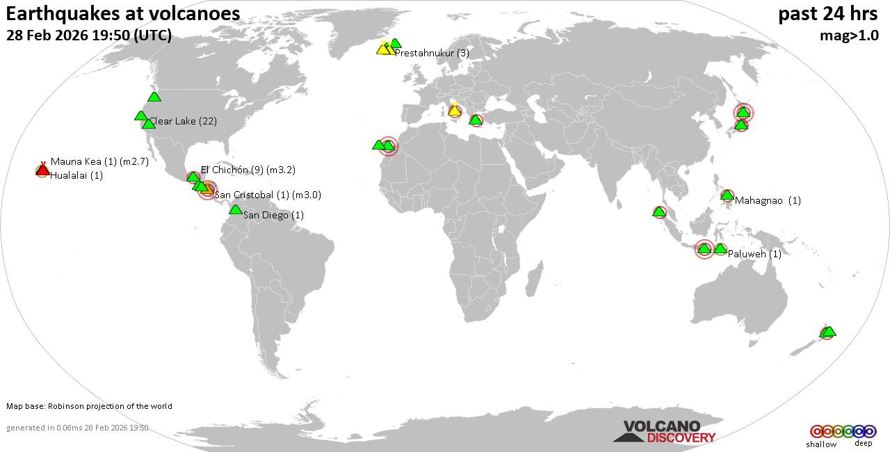 World map showing volcanoes with shallow (less than 50 km) earthquakes within 20 km radius during the past 24 hours on 28 Feb 2026 Number in brackets indicate nr of quakes. Quakes detected near: Bratan (1 quake mag 3.0), Cabalian (1 quake mag 2.2), Campi Flegrei (Phlegrean Fields) (22 quakes between mag 0.1-3.5), Clear Lake (20 quakes between mag 0.2-1.2), Coso (5 quakes between mag 0.9-2.0), El Chichón (10 quakes between mag 2.2-3.2)
Etna (2 quakes between mag 1.5-1.8), Geureudong (1 quake mag 2.1), Grímsnes (3 quakes between mag 0.4-1.6), Hualalai (1 quake mag 2.0), Iliniza (1 quake mag 3.0), Katla (4 quakes between mag 0.3-1.2), Kilauea (3 quakes between mag 1.7-1.8), La Palma (1 quake mag 1.7), Loihi (1 quake mag 1.7), Mahagnao (1 quake mag 2.2), Mauna Kea (1 quake mag 2.7), Methana (1 quake mag 2.0), Ontake-san (1 quake mag 2.5), Osore-yama (1 quake mag 3.0), Pacaya (2 quakes between mag 0.0-2.5), Paluweh (1 quake mag 2.4), Prestahnukur (1 quake mag 1.1), San Cristobal (1 quake mag 3.0), San Diego (1 quake mag 1.2), San Salvador (1 quake mag 1.8), Svartsengi (2 quakes between mag 0.5-1.1), Tjörnes Fracture Zone (3 quakes between mag 0.5-1.7), Torfajökull (3 quakes between mag 0.9-1.2), West Crater (1 quake mag 1.8), Whale Island (1 quake mag 2.1) (updated 16h50)
Note: Earthquakes within 20 km from and at depths less than 50 km under active volcanoes are reported. The list is not complete because many volcanoes are not monitored and/or seismic data in high resolution is not available publicly.
Volcanoes with recent earthquakes above magnitude 2 or more than 10 quakes are listed below:
Bratan volcano (Bali): magnitude 3.0 earthquakeA magnitude 3.0 earthquake occurred at the volcano 11 hours ago. The quake, which might be volcanic in origin, was located at a depth of 10.00 km depth at 1 km distance SSE from the volcano. Earthquake details: Reported seismic-like event (likely no quake): 20 km south of Singaraja, Kabupaten Buleleng, Provinsi Bali, Indonesia, Feb 28, 2026 01:56 pm (GMT +8) (1 km SSE) All earthquakes at BratanCabalian volcano (Central Philippines): magnitude 2.2 earthquakeA magnitude 2.2 earthquake occurred at the volcano 23 hours ago. The quake, which might be volcanic in origin, was located at a depth of 28.00 km depth at 17 km distance NW from the volcano. Earthquake details: 2.2 quake Province of Southern Leyte, 41 km south of Abuyog, Philippines, Feb 28, 2026 01:25 am (GMT +8) (17 km NW) All earthquakes at CabalianCampi Flegrei (Phlegrean Fields) volcano (Italy): 22 earthquakes up to magnitude 3.5Possible earthquake swarm: 22 earthquakes occurred near (under) the volcano during 13 hours, the last being recorded quake 3 hours ago. Hypocenter depths ranged between 3.22 and 0.61 km. Earthquake details: (only 5 largest) 3.5 quake 10.9 km west of Naples, Napoli, Campania, Italy, Feb 28, 2026 11:19 am (GMT +1) (5 km N) 2.3 quake 4 km east of Pozzuoli, Napoli, Campania, Italy, Feb 28, 2026 11:22 am (GMT +1) (1 km N) 1.4 quake 3.8 km east of Pozzuoli, Napoli, Campania, Italy, Feb 28, 2026 01:51 pm (GMT +1) (1 km NNW) 1.2 quake 3.4 km southeast of Pozzuoli, Napoli, Campania, Italy, Feb 28, 2026 02:38 pm (GMT +1) (1 km NW) 1.2 quake 3.4 km southeast of Pozzuoli, Napoli, Campania, Italy, Feb 28, 2026 11:20 am (GMT +1) (1 km NW) All earthquakes at Campi Flegrei (Phlegrean Fields)Clear Lake volcano (California): 20 earthquakes up to magnitude 1.2Possible earthquake swarm: 20 earthquakes occurred near (under) the volcano during 20 hours, the last being recorded quake 2 hours ago. Hypocenter depths ranged between 8.58 and 0.43 km. Earthquake details: (only 5 largest) 1.2 quake 28 mi north of Santa Rosa, Sonoma County, California, United States, Feb 27, 2026 05:37 pm (GMT -8) (16 km SSW) 1.1 quake 28 mi north of Santa Rosa, Sonoma County, California, United States, Feb 27, 2026 07:02 pm (GMT -8) (16 km SSW) 1.0 quake 27 mi north of Santa Rosa, Sonoma County, California, United States, Feb 27, 2026 10:27 am (GMT -8) (16 km SSW) 1.0 quake Lake County, 28 mi north of Santa Rosa, Sonoma County, California, United States, Feb 28, 2026 06:13 am (GMT -8) (15 km SSW) 1.0 quake 28 mi north of Santa Rosa, Sonoma County, California, United States, Feb 28, 2026 04:32 am (GMT -8) (15 km SSW) All earthquakes at Clear LakeEl Chichón volcano (Southern Mexico): 10 earthquakes up to magnitude 3.210 earthquakes occurred near (under) the volcano during 16 hours, the last being recorded quake 7 hours ago. Hypocenter depths ranged between 3.00 and 2.00 km. Earthquake details: (only 5 largest) 3.2 quake Estado de Chiapas, 37 km southwest of Teapa, Estado de Tabasco, Mexico, Feb 27, 2026 08:41 pm (GMT -6) (1 km NNW) 2.9 quake Estado de Chiapas, 37 km southwest of Teapa, Estado de Tabasco, Mexico, Feb 27, 2026 07:23 pm (GMT -6) (2 km NW) 2.7 quake Estado de Chiapas, 37 km southwest of Teapa, Estado de Tabasco, Mexico, Feb 27, 2026 04:48 pm (GMT -6) (1 km NNW) 2.6 quake Estado de Chiapas, 37 km southwest of Teapa, Estado de Tabasco, Mexico, Feb 27, 2026 10:47 pm (GMT -6) (1 km NNW) 2.4 quake Estado de Chiapas, 38 km southwest of Teapa, Estado de Tabasco, Mexico, Feb 27, 2026 06:57 pm (GMT -6) (1 km SW) All earthquakes at El ChichónGeureudong volcano (Sumatra): magnitude 2.1 earthquakeA magnitude 2.1 earthquake occurred at the volcano 21 hours ago. The quake, which might be volcanic in origin, was located at a depth of 10.00 km depth at 6 km distance ESE from the volcano. Earthquake details: 2.1 quake Kabupaten Bener Meriah, 58 km southwest of Lhokseumawe, Indonesia, Feb 28, 2026 02:31 am (GMT +7) (6 km ESE) All earthquakes at GeureudongIliniza volcano (Ecuador): magnitude 3.0 earthquakeA magnitude 3.0 earthquake occurred at the volcano 21 hours ago. The quake, which might be volcanic in origin, was located at a depth of 10.00 km depth at 18 km distance SSE from the volcano. Earthquake details: Reported seismic-like event (likely no quake): 14 km north of Latacunga, Provincia de Cotopaxi, Ecuador, Feb 27, 2026 02:33 pm (GMT -5) (18 km SSE) All earthquakes at IlinizaMahagnao volcano (Central Philippines): magnitude 2.2 earthquakeA magnitude 2.2 earthquake occurred at the volcano 1 hour 44 minutes ago. The quake, which might be volcanic in origin, was located at a depth of 3.00 km depth at 12 km distance SSW from the volcano. Earthquake details: 2.2 quake 21 km south of Burauen, Province of Leyte, Eastern Visayas, Philippines, Feb 28, 2026 11:06 pm (GMT +8) (12 km SSW) All earthquakes at Mahagnao Mauna Kea volcano (Hawai'i (Big Island)): magnitude 2.7 earthquakeA magnitude 2.7 earthquake occurred at the volcano 13 hours ago. The quake, which might be volcanic in origin, was located at a depth of 48.31 km depth at 19 km distance NW from the volcano. Earthquake details: 2.7 quake 8 mi southeast of Waimea, Hawaii County, Hawaii, United States, Feb 27, 2026 05:55 pm (GMT -10) (19 km NW) All earthquakes at Mauna KeaOntake-san volcano (Honshu): magnitude 2.5 earthquakeA magnitude 2.5 earthquake occurred at the volcano 18 hours ago. The quake, which might be volcanic in origin, was located at a depth of 7.00 km depth at 15 km distance E from the volcano. Earthquake details: 2.5 quake 29 km west of Ina, Nagano, Japan, Feb 28, 2026 07:59 am (GMT +9) (15 km E) All earthquakes at Ontake-sanOsore-yama volcano (Honshu): magnitude 3.0 earthquakeA magnitude 3.0 earthquake occurred at the volcano 12 hours ago. The quake, which might be volcanic in origin, was located at a depth of 10.00 km depth at 4 km distance NE from the volcano. Earthquake details: Reported quake or seismic-like event: 37 km southwest of Hachinohe, Aomori, Japan, Feb 28, 2026 02:18 pm (GMT +9) (4 km NE) All earthquakes at Osore-yamaPacaya volcano (Guatemala): 2 earthquakes up to magnitude 2.52 earthquakes occurred near (under) the volcano at nearly the same time (03:47 UTC). Hypocenter depths ranged between 5.00 and 5.00 km. Earthquake details: 2.5 quake 8.4 km east of Palin, Departamento de Escuintla, Guatemala, Feb 27, 2026 09:47 pm (GMT -6) (2 km WNW) 0.0 quake Departamento de Escuintla, 29 km southwest of Guatemala City, Guatemala, Feb 27, 2026 09:47 pm (GMT -6) (3 km NW) All earthquakes at PacayaPaluweh volcano (Lesser Sunda Islands): magnitude 2.4 earthquakeA magnitude 2.4 earthquake occurred at the volcano 12 hours ago. The quake, which might be volcanic in origin, was located at a depth of 27.00 km depth at 8 km distance NNW from the volcano. Earthquake details: 2.4 quake Flores Sea, 65 km north of Ende, Kabupaten Ende, East Nusa Tenggara, Indonesia, Feb 28, 2026 12:22 pm (GMT +8) (8 km NNW) All earthquakes at PaluwehSan Cristobal volcano (Nicaragua): magnitude 3.0 earthquakeA magnitude 3.0 earthquake occurred at the volcano 12 hours ago. The quake, which might be volcanic in origin, was located at a depth of 10.00 km depth at 10 km distance NNW from the volcano. Earthquake details: Reported seismic-like event (likely no quake): 19 km northeast of Chinandega, Departamento de Chinandega, Nicaragua, Feb 27, 2026 10:34 pm (GMT -6) (10 km NNW) All earthquakes at San CristobalWhale Island volcano (New Zealand): magnitude 2.1 earthquakeA magnitude 2.1 earthquake occurred at the volcano 6 hours ago. The quake, which might be volcanic in origin, was located at a depth of 5.00 km depth at 10 km distance SW from the volcano. Earthquake details: 2.1 quake 9.7 km northwest of Whakatane, Bay of Plenty, New Zealand, Mar 1, 2026 12:17 am (GMT +13) (10 km SW) All earthquakes at Whale Islandhttps://www.volcanodiscovery.com/earthquakes-volcanoes/news/296173/Volcano-earthquake-report-for-Saturday-28-Feb-2026.html
|
|


CMS The Best Conveyancing solicitors conveyancing quotes throughout the UK
For any webhosting enquiries please email webmaster@aus-city.com
|
|
Forums60
Topics786,013
Posts820,783
Members2,960
| |
Most Online22,463
May 9th, 2026
|
|
|
|
|
Copyright 1996 - 2026 by David Cottle. Designed by David Bate Jr. All Rights Reserved.
By using this forum, the user agrees not to transfer any data or technical information received under this agreement to any other entity without the express approval of the AUS-CITY Forum Admins and/or authors of individual posts (Forum Admins and DoD/USSPACECOM for the analysis of satellite tracking data).
Two-line elements (TLE) and all other satellite data presented and distributed via this forum and AUS-CITY mailing lists are distributed with permission from DoD/USSTRATCOM.

|

|


 - Click image for larger picture.")


