|
|
|
1 members (Webmaster),
2,442
guests, and
20
robots. |
|
Key:
Admin,
Global Mod,
Mod
|
|
S |
M |
T |
W |
T |
F |
S |
|
|
|
|
|
|
1
|
2
|
|
3
|
4
|
5
|
6
|
7
|
8
|
9
|
|
10
|
11
|
12
|
13
|
14
|
15
|
16
|
|
17
|
18
|
19
|
20
|
21
|
22
|
23
|
|
24
|
25
|
26
|
27
|
28
|
29
|
30
|
|
31
|
|
|
|
|
|
|
|
There are no members with birthdays on this day. |
|
|
|
|
|
|
|
|
|
|
|
|
by Webmaster - Wed 20 May 2026 12:27:AM
|
by Webmaster - Wed 20 May 2026 12:27:AM
|
by Webmaster - Wed 20 May 2026 12:27:AM
|
|
|

World Earthquake Report for Tuesday, 19 May 2026
• Volcano earthquake report for Tuesday, 19 May 2026
• Magnitude 5.2 earthquake strikes near Kahoku, Kahoku Shi, Ishikawa-ken, Jap...
• Moderate mag. 4.7 earthquake - Southern Iran on Tuesday, May 19, 2026, at 1...
• Strong mag. 5.2 earthquake - Sea of Japan or East Sea, 98 km northwest of K...
• Moderate mag. 4.5 earthquake - 25 km northwest of Takayama, Gifu, Japan, on...
|

#801938
Tue 10 Mar 2026 11:50:PM
|
Joined: Feb 2001
Posts: 381,904
Launch Director
|
OP

Launch Director
Joined: Feb 2001
Posts: 381,904 |
Volcano earthquake report for Tuesday, 10 Mar 2026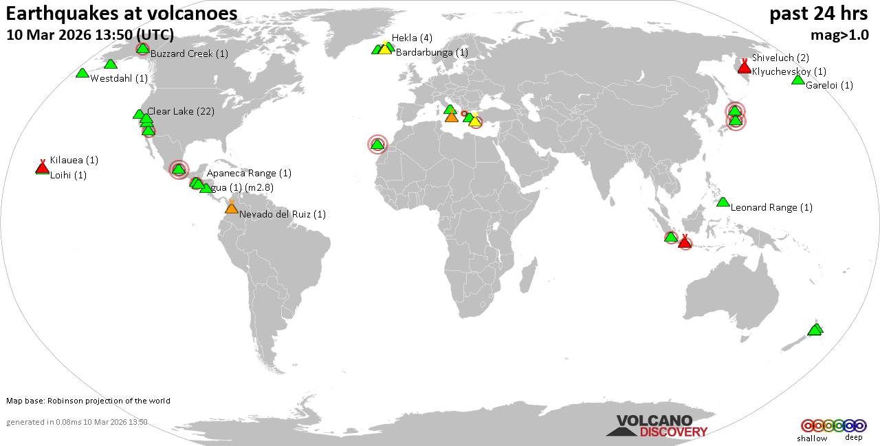 World map showing volcanoes with shallow (less than 50 km) earthquakes within 20 km radius during the past 24 hours on 10 Mar 2026 Number in brackets indicate nr of quakes. Quakes detected near: Aliso (1 quake mag 2.4), Apaneca Range (1 quake mag 1.8), Apoyeque (1 quake mag 1.2), Bardarbunga (5 quakes between mag 0.1-1.2), Buzzard Creek (1 quake mag 2.4), Clear Lake (23 quakes between mag 0.2-3.0)
Coso (9 quakes between mag 0.2-1.3), Eldey (2 quakes between mag 1.2-1.6), Etna (1 quake mag 1.0), Haleakala (1 quake mag 2.8), Hekla (6 quakes between mag 0.1-1.8), Hrómundartindur (1 quake mag 1.0), Katla (8 quakes between mag 0.0-1.2), Kilauea (1 quake mag 1.8), Leonard Range (1 quake mag 1.6), Loihi (3 quakes between mag 1.7-2.6), Long Valley (2 quakes between mag 0.9-1.4), Maderas (1 quake mag 2.5), Maroa (2 quakes between mag 1.6-1.7), Maunaloa (3 quakes between mag 0.9-2.4), Methana (1 quake mag 1.7), Nevado del Ruiz (1 quake mag 1.5), Osore-yama (1 quake mag 3.0), Papayo (1 quake mag 3.0), Prestahnukur (1 quake mag 1.1), Salton Buttes (4 quakes between mag 1.0-2.2), Snaefellsjökull (1 quake mag 1.5), Tambora (2 quakes between mag 2.1-2.2), Tenerife (3 quakes between mag 0.9-3.0), Tongariro (1 quake mag 1.0), Torfajökull (3 quakes between mag 0.4-1.4), Trident (1 quake mag 1.0), Vesuvius (1 quake mag 1.0) (updated 23h50)
Note: Earthquakes within 20 km from and at depths less than 50 km under active volcanoes are reported. The list is not complete because many volcanoes are not monitored and/or seismic data in high resolution is not available publicly.
Volcanoes with recent earthquakes above magnitude 2 or more than 10 quakes are listed below:
Aliso volcano (Ecuador): magnitude 2.4 earthquakeA magnitude 2.4 earthquake occurred at the volcano 12 hours ago. The quake, which might be volcanic in origin, was located at a depth of 0 km depth at 12 km distance NE from the volcano. Earthquake details: 2.4 quake Provincia de Napo, 72 km east of Quito, Provincia de Pichincha, Ecuador, Mar 10, 2026 07:08 am (GMT -5) (12 km NE) All earthquakes at AlisoBuzzard Creek volcano (Eastern Alaska): magnitude 2.4 earthquakeA magnitude 2.4 earthquake occurred at the volcano 24 hours ago. The quake, which might be volcanic in origin, was located at a depth of 5.00 km depth at 15 km distance WSW from the volcano. Earthquake details: 2.4 quake 14 mi northeast of Healy, Denali Borough, Alaska, United States, Mar 9, 2026 04:09 pm (GMT -8) (15 km WSW) All earthquakes at Buzzard CreekClear Lake volcano (California): 23 earthquakes up to magnitude 3.0Possible earthquake swarm: 23 earthquakes occurred near (under) the volcano during 21 hours, the last being recorded quake 1 hour 59 minutes ago. Hypocenter depths ranged between 11.66 and 1.34 km. Earthquake details: (only 5 largest) Reported seismic-like event (likely no quake): 0.4 mi north of Clearlake, Lake County, California, United States, Mar 10, 2026 12:45 pm (GMT -7) (12 km E) 1.3 quake 27 mi north of Santa Rosa, Sonoma County, California, United States, Mar 10, 2026 02:50 pm (GMT -7) (16 km SSW) 1.3 quake 27 mi north of Santa Rosa, Sonoma County, California, United States, Mar 9, 2026 09:27 pm (GMT -7) (17 km S) 1.3 quake 27 mi north of Santa Rosa, Sonoma County, California, United States, Mar 9, 2026 10:15 pm (GMT -7) (17 km SSW) 1.2 quake 27 mi north of Santa Rosa, Sonoma County, California, United States, Mar 10, 2026 01:36 pm (GMT -7) (18 km SSW) All earthquakes at Clear LakeHaleakala volcano (Hawaiian Islands): magnitude 2.8 earthquakeA magnitude 2.8 earthquake occurred at the volcano 3 hours ago. The quake, which might be volcanic in origin, was located at a depth of 1.54 km depth at 19 km distance SW from the volcano. Earthquake details: 2.8 quake 21 mi south of Kahului, Maui County, Hawaii, United States, Mar 10, 2026 11:05 am (GMT -10) (19 km SW) All earthquakes at HaleakalaLoihi volcano (Hawai'i (Big Island)): 3 earthquakes up to magnitude 2.63 earthquakes occurred near (under) the volcano during 10 hours, the last being recorded quake 4 hours ago. Hypocenter depths ranged between 35.80 and 10.85 km. Earthquake details: 2.6 quake North Pacific Ocean, 51 mi south of Hilo, Hawaii County, Hawaii, United States, Mar 10, 2026 03:51 am (GMT -10) (10 km N) 1.7 quake North Pacific Ocean, 42 mi southeast of of Hawai‘i Island, Hawaii County, Hawaii, United States, Mar 10, 2026 09:30 am (GMT -10) (15 km NW) 1.7 quake 20 km ESE of Naalehu, Hawaii, Mar 9, 2026 11:12 pm (GMT -10) (16 km NW) All earthquakes at LoihiMaderas volcano (Nicaragua): magnitude 2.5 earthquakeA magnitude 2.5 earthquake occurred at the volcano 8 hours ago. The quake, which might be volcanic in origin, was located at a depth of 9.00 km depth at 7 km distance WNW from the volcano. Earthquake details: 2.5 quake 28 km east of Rivas, Departamento de Rivas, Nicaragua, Mar 10, 2026 09:23 am (GMT -6) (7 km WNW) All earthquakes at MaderasMaunaloa volcano (Hawai'i (Big Island)): 3 earthquakes up to magnitude 2.43 earthquakes occurred near (under) the volcano during 50 minutes, the last being recorded quake 9 hours ago. Hypocenter depths ranged between 4.44 and 1.52 km. Earthquake details: 2.4 quake 29 mi southwest of Hilo, Hawaii County, Hawaii, United States, Mar 10, 2026 03:36 am (GMT -10) (16 km E) 2.2 quake 29 mi southwest of Hilo, Hawaii County, Hawaii, United States, Mar 10, 2026 03:36 am (GMT -10) (16 km E) 0.9 quake 30 mi southwest of Hilo, Hawaii County, Hawaii, United States, Mar 10, 2026 04:26 am (GMT -10) (13 km ENE) All earthquakes at MaunaloaOsore-yama volcano (Honshu): magnitude 3.0 earthquakeA magnitude 3.0 earthquake occurred at the volcano 21 hours ago. The quake, which might be volcanic in origin, was located at a depth of 10.00 km depth at 7 km distance NE from the volcano. Earthquake details: Reported quake or seismic-like event: 33 km southwest of Hachinohe, Aomori, Japan, Mar 10, 2026 12:11 pm (GMT +9) (7 km NE) All earthquakes at Osore-yamaPapayo volcano (Western & Central Mexico): magnitude 3.0 earthquakeA magnitude 3.0 earthquake occurred at the volcano 21 hours ago. The quake, which might be volcanic in origin, was located at a depth of 10.00 km depth at 6 km distance NNE from the volcano. Earthquake details: Reported quake or seismic-like event: 31 km east of Xico, México, Mexico, Mar 9, 2026 08:32 pm (GMT -6) (6 km NNE) All earthquakes at PapayoSalton Buttes volcano (California): 4 earthquakes up to magnitude 2.24 earthquakes occurred near (under) the volcano during 8 hours, the last being recorded quake 13 hours ago. Hypocenter depths ranged between 11.13 and 2.47 km. Earthquake details: 2.2 quake 15 mi north of Brawley, Imperial County, California, United States, Mar 10, 2026 04:15 am (GMT -7) (2 km SSE) 1.7 quake 11 mi northwest of Brawley, Imperial County, California, United States, Mar 9, 2026 08:16 pm (GMT -7) (9 km S) 1.6 quake 12 mi northwest of Brawley, Imperial County, California, United States, Mar 9, 2026 08:01 pm (GMT -7) (8 km S) 1.0 quake 12 mi northwest of Brawley, Imperial County, California, United States, Mar 9, 2026 08:08 pm (GMT -7) (9 km S) All earthquakes at Salton ButtesTambora volcano (Sumbawa): 2 earthquakes up to magnitude 2.22 earthquakes occurred near (under) the volcano during 1 hour 52 minutes, the last being recorded quake 4 hours ago. Hypocenter depths ranged between 13.00 and 10.00 km. Earthquake details: 2.2 quake 56 km northwest of Dompu, Kabupaten Dompu, West Nusa Tenggara, Indonesia, Mar 11, 2026 03:22 am (GMT +8) (6 km SSE) 2.1 quake Kabupaten Bima, 60 km northeast of Sumbawa Besar, Indonesia, Mar 11, 2026 01:30 am (GMT +8) (14 km WNW) All earthquakes at TamboraTenerife volcano (Canary Islands): 3 earthquakes up to magnitude 3.03 earthquakes occurred near (under) the volcano during 4 hours, the last being recorded quake 19 hours ago. Hypocenter depths ranged between 14.00 and 10.00 km. Earthquake details: Reported seismic-like event (likely no quake): 27 km west of La Laguna, Santa Cruz de Tenerife, Canary Islands, Spain, Mar 10, 2026 04:20 am (GMT +0) (16 km NNE) 1.1 quake 16 km north of Arona, Santa Cruz de Tenerife, Canary Islands, Spain, Mar 10, 2026 12:26 am (Universal Time) (5 km SW) 0.9 quake 16 km north of Arona, Santa Cruz de Tenerife, Canary Islands, Spain, Mar 10, 2026 12:26 am (Universal Time) (5 km SW) All earthquakes at Tenerifehttps://www.volcanodiscovery.com/earthquakes-volcanoes/news/297165/Volcano-earthquake-report-for-Tuesday-10-Mar-2026.html
|
|


CMS The Best Conveyancing solicitors conveyancing quotes throughout the UK
For any webhosting enquiries please email webmaster@aus-city.com
|
|
Forums60
Topics775,556
Posts810,348
Members2,960
| |
Most Online22,463
May 9th, 2026
|
|
|
|
|
Copyright 1996 - 2026 by David Cottle. Designed by David Bate Jr. All Rights Reserved.
By using this forum, the user agrees not to transfer any data or technical information received under this agreement to any other entity without the express approval of the AUS-CITY Forum Admins and/or authors of individual posts (Forum Admins and DoD/USSPACECOM for the analysis of satellite tracking data).
Two-line elements (TLE) and all other satellite data presented and distributed via this forum and AUS-CITY mailing lists are distributed with permission from DoD/USSTRATCOM.

|

|


 - Click image for larger picture.")


