|
|
|
0 members (),
2,782
guests, and
25
robots. |
|
Key:
Admin,
Global Mod,
Mod
|
|
S |
M |
T |
W |
T |
F |
S |
|
|
|
1
|
2
|
3
|
4
|
5
|
|
6
|
7
|
8
|
9
|
10
|
11
|
12
|
|
13
|
14
|
15
|
16
|
17
|
18
|
19
|
|
20
|
21
|
22
|
23
|
24
|
25
|
26
|
|
27
|
28
|
29
|
30
|
|
|
|
|
There are no members with birthdays on this day. |
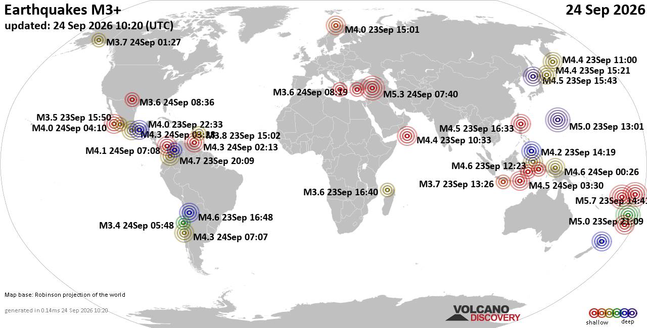
World Earthquake Report for Thursday, 24 September 2026
• Moderate mag. 4.3 earthquake - Madagascar: Mozambique Channel on Thursday, ...
• Small magnitude 3.9 earthquake hits near Hastings, Hastings District, Hawke...
• Volcano earthquake report for Thursday, 24 September 2026
• Light mag. 3.9 earthquake - South Pacific Ocean, 10.2 km south of Hastings,...
• Moderate magnitude 4.1 quake hits 31 miles southeast of Midland, Texas, Uni...
|

#804928
Thu 09 Apr 2026 12:53:PM
|
Joined: Feb 2001
Posts: 678,977
Launch Director
|
|
Launch Director
Joined: Feb 2001
Posts: 678,977 |
SPC Apr 9, 2026 1300 UTC Day 1 Convective OutlookSPC 1300Z Day 1 Outlook 
Day 1 Convective Outlook
NWS Storm Prediction Center Norman OK
0750 AM CDT Thu Apr 09 2026

Valid 091300Z - 101200Z

...THERE IS A SLIGHT RISK OF SEVERE THUNDERSTORMS ACROSS THE CENTRAL
PLAINS AND LOWER/MIDDLE MISSOURI VALLEY...

...SUMMARY...
Severe storms capable of large hail and severe wind gusts are
expected late this afternoon and evening across Kansas, southeast
Nebraska into northwest Missouri and southwest Iowa. Isolated severe
storms may also occur across the south-central High Plains and
northern California/western Oregon.

...Central Plains and Lower/Middle Missouri Valley...
A frontal zone will focus and shift northward toward across Kansas
toward the Kansas/Nebraska and Iowa/Missouri border vicinities
today, before gradually accelerating southeastward tonight. The
region will be influenced later today by a secondary shortwave
trough digging southeastward over the northern Plains, with the
persistence of cyclonic and somewhat strengthening mid/upper-level
flow. On the nose of south-southwesterly lower tropospheric winds,
low-level moisture will diurnally increase along/south of the front,
offset by ample mixing across Kansas, resulting in surface dewpoints
mainly in the lower/middle 50s F into peak heating. Beneath very
steep mid-level lapse rates, 1000-1500 J/kg MLCAPE values are
expected near/south of the front.

After some early day thunderstorms, more intense surface-based
thunderstorm development should occur as early as 22-23z/5-6pm CDT
near the boundary including portions of northern Kansas/southeast
Nebraska to the Iowa/Missouri border region, with other more
isolated and higher-based storms possible across western Kansas and
the nearby High Plains in vicinity of the lee trough/surface low.

Moderately strong westerlies will reside along/north of the
boundary, with 40+ kt effective shear supporting supercells capable
of large hail, potentially some in excess of 2 inches in diameter.
Some tornado potential may exist mainly across northeast Kansas/far
southeast Nebraska and northwest Missouri near the boundary, but
this overall potential will tend to be mitigated by modest-caliber
moisture and the influence of diurnal mixing. Severe winds are also
possible into evening as storms tend to cluster and spread/increase
east-southeastward during the evening, although the modest early
season moisture and nocturnal influences will lead to a diminished
intensity trend into late evening.

...Northern California/western Oregon...
As the upper-level low approaches the West Coast, forcing for ascent
will overspread portions of northern California into southern Oregon
with scattered thunderstorm development expected into afternoon.
Sufficient moisture and CAPE will exist inland beneath strengthening
deep-layer southwesterly winds ahead of the trough. As lapse rates
steepen and flow aloft increases, storms may be capable of strong to
severe wind gusts and possibly some hail.

..Guyer/Weinman.. 04/09/2026
Read morehttps://www.spc.noaa.gov/products/outlook/day1otlk_1300.html
|
|



CMS The Best Conveyancing solicitors conveyancing quotes throughout the UK
For any webhosting enquiries please email webmaster@aus-city.com
|
|
Forums60
Topics840,728
Posts875,523
Members2,960
| |
Most Online102,106
Jul 10th, 2026
|
|
|
|
|

|





































