|
|
|
0 members (),
2,650
guests, and
27
robots. |
|
Key:
Admin,
Global Mod,
Mod
|
|
S |
M |
T |
W |
T |
F |
S |
|
|
|
|
1
|
2
|
3
|
4
|
|
5
|
6
|
7
|
8
|
9
|
10
|
11
|
|
12
|
13
|
14
|
15
|
16
|
17
|
18
|
|
19
|
20
|
21
|
22
|
23
|
24
|
25
|
|
26
|
27
|
28
|
29
|
30
|
31
|
|
|
There are no members with birthdays on this day. |

Volcano earthquake report for Friday, 10 Jul 2026
• Moderate mag. 4.2 earthquake - 133 km northwest of Ternate, Kota Ternate, N...
• World Earthquake Report for Friday, 10 July 2026
• Moderate mag. 4.6 earthquake - 17 km southwest of Comalapa, Estado de Chiap...
• Moderate mag. 4.1 earthquake - Olyutorskiy Rayon, 47 km northwest of Tilich...
• Moderate mag. 4.0 earthquake - Hawke's Bay, New Zealand, on Saturday, Jul 1...
|

#808774
Thu 07 May 2026 04:50:PM
|
Joined: Feb 2001
Posts: 678,976
Launch Director
|
OP

Launch Director
Joined: Feb 2001
Posts: 678,976 |
Volcano earthquake report for Thursday, 7 May 2026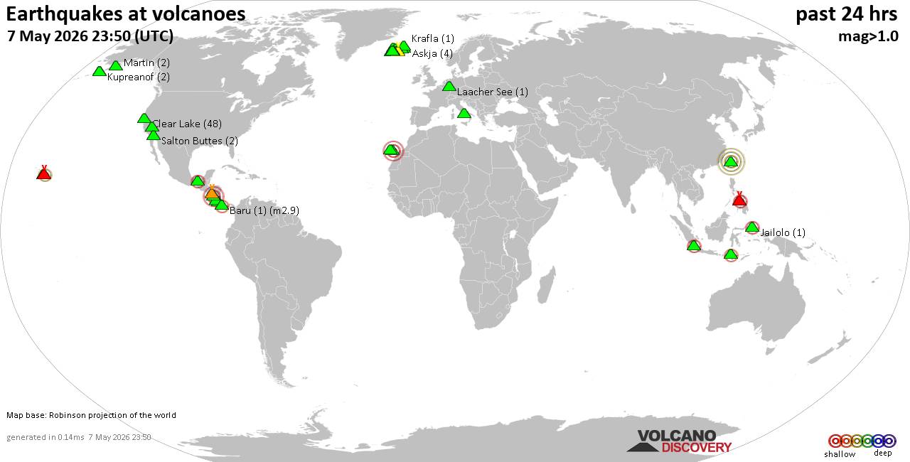 World map showing volcanoes with shallow (less than 50 km) earthquakes within 20 km radius during the past 24 hours on 7 May 2026 Number in brackets indicate nr of quakes. Quakes detected near: Bardarbunga (19 quakes between mag 0.0-1.7), Baru (1 quake mag 2.9), Barva (2 quakes between mag 1.2-1.4), Brennisteinsfjöll (3 quakes between mag 0.0-1.9), Campi Flegrei (Phlegrean Fields) (10 quakes between mag 0.1-3.0), Clear Lake (46 quakes between mag 0.2-2.5)
Coso (6 quakes between mag 0.6-1.6), El Chichón (9 quakes between mag 1.6-2.6), Eldey (17 quakes between mag 0.3-1.9), Esteli (1 quake mag 3.0), Gilbanta (1 quake mag 2.3), Gran Canaria (1 quake mag 3.0), Grímsnes (2 quakes between mag 0.2-1.2), Hulubelu (1 quake mag 2.3), Ischia (1 quake mag 1.7), Jailolo (2 quakes between mag 2.1-2.5), Katla (14 quakes between mag 0.2-2.3), Kilauea (4 quakes between mag 1.7-2.3), Kolumbo (1 quake mag 1.1), Krafla (1 quake mag 1.1), Krísuvík (10 quakes between mag 0.0-1.3), Kupreanof (3 quakes between mag 1.5-2.0), La Palma (1 quake mag 1.8), Laacher See (1 quake mag 1.2), Ljósufjöll (5 quakes between mag 0.0-1.4), Martin (2 quakes between mag 0.3-1.3), Maunaloa (1 quake mag 1.7), Methana (2 quakes between mag 1.0-1.2), Prestahnukur (3 quakes between mag 0.7-1.2), Ruang (1 quake mag 2.9), Salton Buttes (2 quakes between mag 1.0-1.2), Sousaki (3 quakes between mag 0.8-1.2), Stepovak Bay 4 (1 quake mag 1.8), Tenerife (10 quakes between mag 0.4-1.1), Torfajökull (3 quakes between mag 0.0-1.2), Vatnafjöll (2 quakes between mag 0.2-1.8) (updated 16h50)
Note: Earthquakes within 20 km from and at depths less than 50 km under active volcanoes are reported. The list is not complete because many volcanoes are not monitored and/or seismic data in high resolution is not available publicly.
Volcanoes with recent earthquakes above magnitude 2 or more than 10 quakes are listed below:
Bardarbunga volcano (Iceland): 19 earthquakes up to magnitude 1.7Possible earthquake swarm: 19 earthquakes occurred near (under) the volcano during 21 hours, the last being recorded quake 1 hour 9 minutes ago. Hypocenter depths ranged between 3.30 and 0.00 km. Earthquake details: (only 5 largest) 1.7 quake 5.1 km SE of Bárðarbunga May 7, 2026 01:03 pm (Universal Time) (5 km ESE) 1.7 quake 5.6 km ESE of Bárðarbunga May 6, 2026 10:41 pm (Universal Time) (5 km E) 1.3 quake 7.4 km E of Bárðarbunga May 7, 2026 11:23 am (Universal Time) (7 km E) 1.1 quake 3.4 km SW of Bárðarbunga May 6, 2026 07:46 pm (Universal Time) (3 km WSW) 1.0 quake 3.9 km E of Bárðarbunga May 7, 2026 09:10 am (Universal Time) (4 km E) All earthquakes at BardarbungaBaru volcano (Panama): magnitude 2.9 earthquakeA magnitude 2.9 earthquake occurred at the volcano 1 hour 34 minutes ago. The quake, which might be volcanic in origin, was located at a depth of 24.00 km depth at 18 km distance SW from the volcano. Earthquake details: 2.9 quake 36 km northwest of David, Provincia de Chiriqui, Panama, May 7, 2026 10:16 am (GMT -5) (18 km SW) All earthquakes at BaruCampi Flegrei (Phlegrean Fields) volcano (Italy): 10 earthquakes up to magnitude 3.010 earthquakes occurred near (under) the volcano during 20 hours, the last being recorded quake 1 hour 51 minutes ago. Hypocenter depths ranged between 10.00 and 0.56 km. Earthquake details: (only 5 largest) Reported seismic-like event (likely no quake): 3 km west of Naples, Napoli, Campania, Italy, May 7, 2026 12:50 am (GMT +2) (8 km ENE) 0.5 quake 3 km southeast of Pozzuoli, Napoli, Campania, Italy, May 7, 2026 12:38 am (GMT +2) (1 km W) 0.5 quake 4.5 km east of Pozzuoli, Napoli, Campania, Italy, May 6, 2026 09:31 pm (GMT +2) (1 km NE) 0.3 quake 3.3 km southeast of Pozzuoli, Napoli, Campania, Italy, May 7, 2026 04:59 pm (GMT +2) (2 km WSW) 0.3 quake 4.3 km east of Pozzuoli, Napoli, Campania, Italy, May 6, 2026 08:54 pm (GMT +2) (1 km NE) All earthquakes at Campi Flegrei (Phlegrean Fields)Clear Lake volcano (California): 46 earthquakes up to magnitude 2.5Possible earthquake swarm: 46 earthquakes occurred near (under) the volcano during 22 hours, the last being recorded quake 1 hour 28 minutes ago. Hypocenter depths ranged between 4.00 and 0.04 km. Earthquake details: (only 5 largest) 2.5 quake 26 mi north of Santa Rosa, Sonoma County, California, United States, May 7, 2026 02:44 am (GMT -7) (18 km S) 2.3 quake Lake County, 25 mi north of Santa Rosa, Sonoma County, California, United States, May 7, 2026 02:49 am (GMT -7) (18 km S) 2.1 quake 12 mi southwest of Clearlake, Lake County, California, United States, May 7, 2026 02:49 am (GMT -7) (18 km S) 1.8 quake Sonoma County, 13 mi southwest of Clearlake, Lake County, California, United States, May 7, 2026 02:45 am (GMT -7) (17 km S) 1.7 quake Sonoma County, 14 mi southwest of Clearlake, Lake County, California, United States, May 7, 2026 03:02 am (GMT -7) (19 km S) All earthquakes at Clear LakeEl Chichón volcano (Southern Mexico): 9 earthquakes up to magnitude 2.69 earthquakes occurred near (under) the volcano during 12 hours, the last being recorded quake 9 hours ago. Hypocenter depths ranged between 4.40 and 2.90 km. Earthquake details: (only 5 largest) 2.6 quake Estado de Chiapas, 37 km southwest of Teapa, Estado de Tabasco, Mexico, May 6, 2026 09:37 pm (GMT -6) (1 km SSW) 2.5 quake Estado de Chiapas, 37 km southwest of Teapa, Estado de Tabasco, Mexico, May 7, 2026 12:09 am (GMT -6) (1 km SSW) 2.4 quake Estado de Chiapas, 36 km southwest of Teapa, Estado de Tabasco, Mexico, May 6, 2026 05:54 pm (GMT -6) (2 km ESE) 2.4 quake Estado de Chiapas, 37 km southwest of Teapa, Estado de Tabasco, Mexico, May 7, 2026 12:23 am (GMT -6) (1 km NNW) 2.4 quake Estado de Chiapas, 35 km southwest of Teapa, Estado de Tabasco, Mexico, May 6, 2026 01:48 pm (GMT -6) (2 km E) All earthquakes at El ChichónEldey volcano (Iceland): 17 earthquakes up to magnitude 1.9Possible earthquake swarm: 17 earthquakes occurred near (under) the volcano during 19 hours, the last being recorded quake 4 hours ago. Hypocenter depths ranged between 10.00 and 0.00 km. Earthquake details: (only 5 largest) 1.9 quake 7.3 km NNW of Eldey May 7, 2026 07:05 am (Universal Time) (8 km N) 1.7 quake 7.0 km N of Eldey May 7, 2026 07:08 am (Universal Time) (8 km N) 1.5 quake 6.9 km N of Eldey May 7, 2026 07:23 am (Universal Time) (8 km N) 1.4 quake 8.2 km N of Eldey May 7, 2026 07:03 am (Universal Time) (10 km N) 1.2 quake 5.7 km W of Reykjanestá May 7, 2026 01:01 am (Universal Time) (12 km NE) All earthquakes at EldeyEldey is located at the beginning of the Reykjanes Ridge off the SW tip of Iceland. Its highest elevation is the top of Eldey Island, but most of the volcanic edifice is submerged. Several eruptions occurred in historic times, last in 1926. Esteli volcano (Nicaragua): magnitude 3.0 earthquakeA magnitude 3.0 earthquake occurred at the volcano 19 hours ago. The quake, which might be volcanic in origin, was located at a depth of 10.00 km depth at 10 km distance SSE from the volcano. Earthquake details: Reported seismic-like event (likely no quake): 1.8 km southwest of Esteli, Departamento de Esteli, Nicaragua, May 6, 2026 03:34 pm (GMT -6) (10 km SSE) All earthquakes at EsteliGilbanta volcano (Lesser Sunda Islands): magnitude 2.3 earthquakeA magnitude 2.3 earthquake occurred at the volcano 12 hours ago. The quake, which might be volcanic in origin, was located at a depth of 13.00 km depth at 14 km distance SSE from the volcano. Earthquake details: 2.3 quake Flores Sea, East Nusa Tenggara, 14 km southeast of Gili Banta Island, Indonesia, May 7, 2026 12:43 pm (GMT +8) (14 km SSE) All earthquakes at GilbantaGran Canaria volcano (Canary Islands): magnitude 3.0 earthquakeA magnitude 3.0 earthquake occurred at the volcano 6 hours ago. The quake, which might be volcanic in origin, was located at a depth of 10.00 km depth at 18 km distance ESE from the volcano. Earthquake details: Reported seismic-like event (likely no quake): 12 km south of Las Palmas de Gran Canaria, Las Palmas, Canary Islands, Spain, May 7, 2026 11:58 am (GMT +1) (18 km ESE) All earthquakes at Gran CanariaHulubelu volcano (Sumatra): magnitude 2.3 earthquakeA magnitude 2.3 earthquake occurred at the volcano 19 hours ago. The quake, which might be volcanic in origin, was located at a depth of 3.00 km depth at 5 km distance ESE from the volcano. Earthquake details: 2.3 quake Kabupaten Tanggamus, 72 km west of Bandar Lampung, Indonesia, May 7, 2026 04:20 am (GMT +7) (5 km ESE) All earthquakes at HulubeluJailolo volcano (Halmahera): 2 earthquakes up to magnitude 2.52 earthquakes occurred near (under) the volcano during 7 hours, the last being recorded quake 17 hours ago. Hypocenter depths ranged between 8.00 and 6.00 km. Earthquake details: 2.5 quake 35 km north of Ternate, Kota Ternate, North Maluku, Indonesia, May 7, 2026 08:50 am (GMT +9) (2 km N) 2.1 quake Maluku Sea, 38 km north of Ternate, Kota Ternate, North Maluku, Indonesia, May 7, 2026 02:09 am (GMT +9) (6 km NNW) All earthquakes at JailoloKatla volcano (Iceland): 14 earthquakes up to magnitude 2.3Possible earthquake swarm: 14 earthquakes occurred near (under) the volcano during 13 hours, the last being recorded quake 4 hours ago. Hypocenter depths ranged between 5.50 and 0.00 km. Earthquake details: (only 5 largest) 2.3 quake 1.7 km ESE of Goðabunga May 7, 2026 05:52 am (Universal Time) (8 km W) 1.6 quake 6.7 km E of Goðabunga May 7, 2026 09:20 am (Universal Time) (4 km NW) 1.1 quake 6.2 km ENE of Goðabunga May 7, 2026 12:44 pm (Universal Time) (6 km NW) 1.0 quake 5.2 km E of Goðabunga May 7, 2026 10:31 am (Universal Time) (5 km W) 1.0 quake Iceland: 3.8 km SSW of Goðabunga May 7, 2026 09:34 am (Reykjavik time) (12 km WSW) All earthquakes at KatlaKilauea volcano (Hawai'i (Big Island)): 4 earthquakes up to magnitude 2.34 earthquakes occurred near (under) the volcano during 12 hours, the last being recorded quake 9 hours ago. Hypocenter depths ranged between 33.19 and 0.22 km. Earthquake details: 2.3 quake 10.8 mi south of Volcano, Hawaii County, Hawaii, United States, May 6, 2026 10:15 pm (GMT -10) (15 km SSE) 1.9 quake 30 mi south of Hilo, Hawaii County, Hawaii, United States, May 6, 2026 10:15 am (GMT -10) (12 km SSE) 1.8 quake 30 mi southwest of Hilo, Hawaii County, Hawaii, United States, May 6, 2026 04:09 pm (GMT -10) (14 km W) 1.7 quake 26 mi south of Hilo, Hawaii County, Hawaii, United States, May 6, 2026 08:04 pm (GMT -10) (13 km ESE) All earthquakes at KilaueaRuang volcano (Sulawesi & Sangihe Islands): magnitude 2.9 earthquakeA magnitude 2.9 earthquake occurred at the volcano 23 hours ago. The quake, which might be volcanic in origin, was located at a depth of 27.00 km depth at 15 km distance S from the volcano. Earthquake details: 2.9 quake Celebes Sea, 20 km south of Wanua Tagulandang Island, Sulawesi Utara, Indonesia, May 7, 2026 01:46 am (GMT +8) (15 km S) All earthquakes at Ruanghttps://www.volcanodiscovery.com/earthquakes-volcanoes/news/301667/Volcano-earthquake-report-for-Thursday-7-May-2026.html
|
|


CMS The Best Conveyancing solicitors conveyancing quotes throughout the UK
For any webhosting enquiries please email webmaster@aus-city.com
|
|
Forums60
Topics789,850
Posts824,628
Members2,960
| |
Most Online102,106
Jul 10th, 2026
|
|
|
|
|
Copyright 1996 - 2026 by David Cottle. Designed by David Bate Jr. All Rights Reserved.
By using this forum, the user agrees not to transfer any data or technical information received under this agreement to any other entity without the express approval of the AUS-CITY Forum Admins and/or authors of individual posts (Forum Admins and DoD/USSPACECOM for the analysis of satellite tracking data).
Two-line elements (TLE) and all other satellite data presented and distributed via this forum and AUS-CITY mailing lists are distributed with permission from DoD/USSTRATCOM.

|

|


 - Click image for larger picture.")


