|
0 members (),
1,189
guests, and
26
robots. |
|
Key:
Admin,
Global Mod,
Mod
|
|
S |
M |
T |
W |
T |
F |
S |
|
|
|
|
1
|
2
|
3
|
4
|
|
5
|
6
|
7
|
8
|
9
|
10
|
11
|
|
12
|
13
|
14
|
15
|
16
|
17
|
18
|
|
19
|
20
|
21
|
22
|
23
|
24
|
25
|
|
26
|
27
|
28
|
29
|
30
|
31
|
|
|
There are no members with birthdays on this day. |

World Earthquake Report for Sunday, 26 July 2026
• Moderate mag. 4.5 earthquake - Estado de Veracruz-Llave, Mexico, on 2026-07...
• Volcano earthquake report for Sunday, 26 Jul 2026
• Moderate mag. 4.0 earthquake - Kabupaten Kepulauan Talaud, 148 km northeast...
• Light mag. 3.9 earthquake - North Pacific Ocean, 65 km south of Puerto San ...
• Strong mag. 5.4 earthquake - Northern Mid-Atlantic Ridge on Sunday, Jul 26,...
|

#812537
Wed 20 May 2026 08:37:PM
|
Joined: Feb 2001
Posts: 678,976
Launch Director
|
OP

Launch Director
Joined: Feb 2001
Posts: 678,976 |
SPC Severe Thunderstorm Watch 235WW 235 SEVERE TSTM CT DE MD NJ NY PA CW 201805Z - 210100Z 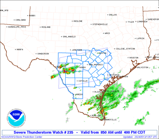
URGENT - IMMEDIATE BROADCAST REQUESTED
Severe Thunderstorm Watch Number 235
NWS Storm Prediction Center Norman OK
205 PM EDT Wed May 20 2026

The NWS Storm Prediction Center has issued a

* Severe Thunderstorm Watch for portions of
  Southern Connecticut
  Delaware
  Eastern Maryland
  New Jersey
  Southeast New York
  Eastern Pennsylvania
  Coastal Waters

* Effective this Wednesday afternoon and evening from 205 PM
  until 900 PM EDT.

* Primary threats include...
  Scattered damaging wind gusts to 70 mph likely
  Isolated large hail events to 1 inch in diameter possible

SUMMARY...Scattered thunderstorms will develop and track eastward
across the watch area through the afternoon and evening.  Hot and
unstable conditions will lead to conditions supportive of damaging
wind gusts in the strongest storms.

The severe thunderstorm watch area is approximately along and 55
statute miles north and south of a line from 35 miles northwest of
Wilmington DE to 25 miles southeast of Groton CT. For a complete
depiction of the watch see the associated watch outline update
(WOUS64 KWNS WOU5).

PRECAUTIONARY/PREPAREDNESS ACTIONS...

REMEMBER...A Severe Thunderstorm Watch means conditions are
favorable for severe thunderstorms in and close to the watch area.
Persons in these areas should be on the lookout for threatening
weather conditions and listen for later statements and possible
warnings. Severe thunderstorms can and occasionally do produce
tornadoes.

&&

OTHER WATCH INFORMATION...CONTINUE...WW 234...

AVIATION...A few severe thunderstorms with hail surface and aloft to
1 inch. Extreme turbulence and surface wind gusts to 60 knots. A few
cumulonimbi with maximum tops to 500. Mean storm motion vector
27030.

...Hart
Read morehttps://www.spc.noaa.gov/products/watch/ww0235.html
|
|


CMS The Best Conveyancing solicitors conveyancing quotes throughout the UK
For any webhosting enquiries please email webmaster@aus-city.com
|
|
Forums60
Topics793,270
Posts828,053
Members2,960
| |
Most Online102,106
Jul 10th, 2026
|
|
|


 - Click image for larger picture.")


