|
|
|
0 members (),
1,983
guests, and
26
robots. |
|
Key:
Admin,
Global Mod,
Mod
|
|
S |
M |
T |
W |
T |
F |
S |
|
|
|
|
1
|
2
|
3
|
4
|
|
5
|
6
|
7
|
8
|
9
|
10
|
11
|
|
12
|
13
|
14
|
15
|
16
|
17
|
18
|
|
19
|
20
|
21
|
22
|
23
|
24
|
25
|
|
26
|
27
|
28
|
29
|
30
|
31
|
|
|
There are no members with birthdays on this day. |
|
|
|
|
|
|
|
|
|
|
|
|
|
|
|
|
|
|
|
|
|
|
by Webmaster - Tue 14 Jul 2026 10:01:PM
|

Volcano earthquake report for Friday, 10 Jul 2026
• Moderate mag. 4.2 earthquake - 133 km northwest of Ternate, Kota Ternate, N...
• World Earthquake Report for Friday, 10 July 2026
• Moderate mag. 4.6 earthquake - 17 km southwest of Comalapa, Estado de Chiap...
• Moderate mag. 4.1 earthquake - Olyutorskiy Rayon, 47 km northwest of Tilich...
• Moderate mag. 4.0 earthquake - Hawke's Bay, New Zealand, on Saturday, Jul 1...
|

#812687
Thu 21 May 2026 10:50:AM
|
Joined: Feb 2001
Posts: 678,976
Launch Director
|
OP

Launch Director
Joined: Feb 2001
Posts: 678,976 |
Volcano earthquake report for Thursday, 21 May 2026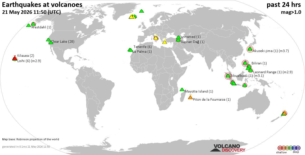 World map showing volcanoes with shallow (less than 50 km) earthquakes within 20 km radius during the past 24 hours on 21 May 2026 Number in brackets indicate nr of quakes. Quakes detected near: Akuseki-jima (1 quake mag 3.7), Bardarbunga (8 quakes between mag 0.1-2.2), Biliran (1 quake mag 2.1), Campi Flegrei (Phlegrean Fields) (31 quakes between mag 0.1-4.1), Clear Lake (25 quakes between mag 0.3-1.8), Coso (2 quakes between mag 0.9-1.4)
Eldey (5 quakes between mag 0.1-1.1), Hulubelu (8 quakes between mag 1.9-2.8), Jan Mayen (1 quake mag 1.6), Katla (8 quakes between mag 0.0-2.3), Kilauea (2 quakes between mag 1.8-2.5), La Palma (1 quake mag 1.4), Leonard Range (1 quake mag 2.9), Loihi (6 quakes between mag 1.8-2.9), Maunaloa (1 quake mag 1.7), Mayotte Island (1 quake mag 1.3), Natib (1 quake mag 3.0), Nevado de Longavi (2 quakes between mag 2.8-3.4), Okataina (Tarawera) (1 quake mag 1.5), Perbakti (1 quake mag 3.0), Piton de la Fournaise (1 quake mag 1.0), Prestahnukur (13 quakes between mag 0.2-1.9), Pulosari (2 quakes between mag 2.3-2.6), Reporoa (1 quake mag 1.4), Sangeang Api (16 quakes between mag 2.0-2.9), Santorini (1 quake mag 1.8), Sibualbuali (1 quake mag 3.1), Stepovak Bay 4 (2 quakes between mag 2.2-2.2), Svartsengi (3 quakes between mag 0.2-1.0), Süphan Dağ (1 quake mag 2.1), Torfajökull (7 quakes between mag 0.0-1.0), Vesuvius (4 quakes between mag 0.1-3.0), Westdahl (1 quake mag 1.0), White Island (2 quakes between mag 2.4-2.6), unnamed (1 quake mag 1.6) (updated 10h50)
Note: Earthquakes within 20 km from and at depths less than 50 km under active volcanoes are reported. The list is not complete because many volcanoes are not monitored and/or seismic data in high resolution is not available publicly.
Volcanoes with recent earthquakes above magnitude 2 or more than 10 quakes are listed below:
Akuseki-jima volcano (Ryukyu Islands): magnitude 3.7 earthquakeA magnitude 3.7 earthquake occurred at the volcano 10 hours ago. The quake, which might be volcanic in origin, was located at a depth of 20.00 km depth at 12 km distance SW from the volcano. Earthquake details: 3.7 quake East China Sea, Kagoshima-ken, 33 km southwest of Suwanose-jima Island, Japan, May 21, 2026 10:11 am (GMT +9) (12 km SW) All earthquakes at Akuseki-jimaBardarbunga volcano (Iceland): 8 earthquakes up to magnitude 2.28 earthquakes occurred near (under) the volcano during 20 hours, the last being recorded quake 2 hours ago. Hypocenter depths ranged between 4.60 and 0.00 km. Earthquake details: (only 5 largest) 2.2 quake 7.2 km ESE of Bárðarbunga May 21, 2026 01:47 am (Universal Time) (8 km E) 1.6 quake 3.1 km S of Bárðarbunga May 21, 2026 04:43 am (Universal Time) (2 km SSE) 1.2 quake 4.0 km SE of Bárðarbunga May 21, 2026 08:34 am (Universal Time) (3 km ESE) 1.0 quake 3.9 km ESE of Bárðarbunga May 20, 2026 03:28 pm (Universal Time) (4 km E) 0.6 quake 5.1 km S of Bárðarbunga May 20, 2026 12:31 pm (Universal Time) (4 km S) All earthquakes at BardarbungaBiliran volcano (Central Philippines): magnitude 2.1 earthquakeA magnitude 2.1 earthquake occurred at the volcano 4 hours ago. The quake, which might be volcanic in origin, was located at a depth of 2.00 km depth at 12 km distance SSW from the volcano. Earthquake details: 2.1 quake 25 km northwest of Carigara, Province of Leyte, Eastern Visayas, Philippines, May 21, 2026 02:24 pm (GMT +8) (12 km SSW) All earthquakes at BiliranCampi Flegrei (Phlegrean Fields) volcano (Italy): 31 earthquakes up to magnitude 4.1Possible earthquake swarm: 31 earthquakes occurred near (under) the volcano during 15 hours, the last being recorded quake 1 hour 49 minutes ago. Hypocenter depths ranged between 7.39 and 0.76 km. Earthquake details: (only 5 largest) 4.1 quake 18 km southwest of Naples, Napoli, Campania, Italy, May 21, 2026 05:50 am (GMT +2) (4 km SW) 2.1 quake Tyrrhenian Sea, 19 km northeast of Isola d'Ischia Island, Italy, May 21, 2026 05:57 am (GMT +2) (11 km SW) 1.3 quake Tyrrhenian Sea, 19 km northeast of Isola d'Ischia Island, Italy, May 21, 2026 02:17 am (GMT +2) (4 km SW) 1.2 quake Tyrrhenian Sea, 18 km northeast of Isola d'Ischia Island, Italy, May 21, 2026 05:53 am (GMT +2) (4 km SW) 0.9 quake Tyrrhenian Sea, 19 km northeast of Isola d'Ischia Island, Italy, May 21, 2026 05:59 am (GMT +2) (4 km SW) All earthquakes at Campi Flegrei (Phlegrean Fields)Clear Lake volcano (California): 25 earthquakes up to magnitude 1.8Possible earthquake swarm: 25 earthquakes occurred near (under) the volcano during 22 hours, the last being recorded quake 18 minutes ago. Hypocenter depths ranged between 9.44 and 1.27 km. Earthquake details: (only 5 largest) 1.8 quake Sonoma County, 14 mi southwest of Clearlake, Lake County, California, United States, May 20, 2026 05:10 pm (GMT -7) (19 km S) 1.6 quake 12 mi southwest of Clearlake, Lake County, California, United States, May 20, 2026 11:52 am (GMT -7) (15 km S) 1.5 quake 13 mi southwest of Clearlake, Lake County, California, United States, May 20, 2026 02:43 pm (GMT -7) (15 km S) 1.5 quake 12 mi southwest of Clearlake, Lake County, California, United States, May 20, 2026 01:02 pm (GMT -7) (15 km S) 1.4 quake Lake County, 27 mi north of Santa Rosa, Sonoma County, California, United States, May 20, 2026 04:02 pm (GMT -7) (16 km S) All earthquakes at Clear LakeHulubelu volcano (Sumatra): 8 earthquakes up to magnitude 2.88 earthquakes occurred near (under) the volcano during 13 hours, the last being recorded quake 6 hours ago. Hypocenter depths ranged between 10.00 and 3.00 km. Earthquake details: (only 5 largest) 2.8 quake Kabupaten Tanggamus, 73 km west of Bandar Lampung, Indonesia, May 21, 2026 11:32 am (GMT +7) (11 km SSE) 2.5 quake Kabupaten Tanggamus, 70 km west of Bandar Lampung, Indonesia, May 21, 2026 09:51 am (GMT +7) (10 km SSE) 2.3 quake Kabupaten Tanggamus, 70 km west of Bandar Lampung, Indonesia, May 21, 2026 09:40 am (GMT +7) (12 km SSE) 2.1 quake Kabupaten Tanggamus, 68 km west of Bandar Lampung, Indonesia, May 21, 2026 09:42 am (GMT +7) (11 km SE) 2.1 quake Kabupaten Tanggamus, 72 km west of Bandar Lampung, Indonesia, May 21, 2026 09:35 am (GMT +7) (11 km SSE) All earthquakes at HulubeluKatla volcano (Iceland): 8 earthquakes up to magnitude 2.38 earthquakes occurred near (under) the volcano during 13 hours, the last being recorded quake 5 hours ago. Hypocenter depths ranged between 1.00 and 0.00 km. Earthquake details: (only 5 largest) 2.3 quake 7.6 km N of Hábunga May 21, 2026 04:02 am (Universal Time) (2 km NW) 1.3 quake 5.3 km NNE of Hábunga May 21, 2026 05:27 am (Universal Time) (2 km SW) 1.1 quake Iceland: 6.1 km E of Goðabunga May 21, 2026 04:09 am (Reykjavik time) (4 km WNW) 0.9 quake 5.9 km N of Hábunga May 21, 2026 03:54 am (Universal Time) (3 km W) 0.8 quake 5.8 km E of Goðabunga May 21, 2026 03:52 am (Universal Time) (4 km WNW) All earthquakes at KatlaKilauea volcano (Hawai'i (Big Island)): 2 earthquakes up to magnitude 2.52 earthquakes occurred near (under) the volcano during 8 minutes, the last being recorded quake 8 hours ago. Hypocenter depths ranged between 30.15 and 29.71 km. Earthquake details: 2.5 quake 36 mi southwest of Hilo, Hawaii County, Hawaii, United States, May 20, 2026 04:37 pm (GMT -10) (17 km SW) 1.8 quake 37 mi southwest of Hilo, Hawaii County, Hawaii, United States, May 20, 2026 04:28 pm (GMT -10) (19 km SW) All earthquakes at KilaueaLeonard Range volcano (Mindanao): magnitude 2.9 earthquakeA magnitude 2.9 earthquake occurred at the volcano 1 hour 37 minutes ago. The quake, which might be volcanic in origin, was located at a depth of 6.00 km depth at 5 km distance WSW from the volcano. Earthquake details: 2.9 quake 17 km east of Maco, Davao de Oro, Davao, Philippines, May 21, 2026 05:13 pm (GMT +8) (5 km WSW) All earthquakes at Leonard RangeLoihi volcano (Hawai'i (Big Island)): 6 earthquakes up to magnitude 2.96 earthquakes occurred near (under) the volcano during 13 hours, the last being recorded quake 5 hours ago. Hypocenter depths ranged between 34.97 and 15.61 km. Earthquake details: (only 5 largest) 2.9 quake North Pacific Ocean, 42 mi southeast of of Hawai‘i Island, Hawaii County, Hawaii, United States, May 20, 2026 07:01 pm (GMT -10) (14 km NW) 2.6 quake North Pacific Ocean, 39 mi southeast of of Hawai‘i Island, Hawaii County, Hawaii, United States, May 20, 2026 01:45 pm (GMT -10) (19 km NW) 2.3 quake North Pacific Ocean, 12 mi southeast of Pāhala, Hawaii County, Hawaii, United States, May 20, 2026 07:33 pm (GMT -10) (18 km NW) 2.2 quake North Pacific Ocean, 14 mi southeast of Pāhala, Hawaii County, Hawaii, United States, May 20, 2026 02:33 pm (GMT -10) (16 km NW) 1.9 quake North Pacific Ocean, 41 mi southeast of of Hawai‘i Island, Hawaii County, Hawaii, United States, May 20, 2026 10:15 am (GMT -10) (15 km NNW) All earthquakes at LoihiNatib volcano (Luzon Island): magnitude 3.0 earthquakeA magnitude 3.0 earthquake occurred at the volcano 19 hours ago. The quake, which might be volcanic in origin, was located at a depth of 10.00 km depth at 17 km distance NNE from the volcano. Earthquake details: Reported seismic-like event (likely no quake): 30 km southwest of San Fernando, Philippines, May 21, 2026 12:13 am (GMT +8) (17 km NNE) All earthquakes at NatibNevado de Longavi volcano (Central Chile and Argentina): 2 earthquakes up to magnitude 3.42 earthquakes occurred near (under) the volcano during 11 minutes, the last being recorded quake 23 hours ago. Hypocenter depths ranged between 7.00 and 6.80 km. Earthquake details: 3.4 quake 51 km southeast of Linares, Provincia de Linares, Region del Maule, Chile, May 20, 2026 07:33 am (GMT -4) (11 km WSW) 2.8 quake 47 km southeast of Linares, Provincia de Linares, Region del Maule, Chile, May 20, 2026 07:22 am (GMT -4) (11 km W) All earthquakes at Nevado de LongaviPerbakti volcano (West Java): magnitude 3.0 earthquakeA magnitude 3.0 earthquake occurred at the volcano 6 hours ago. The quake, which might be volcanic in origin, was located at a depth of 9.00 km depth at 17 km distance SE from the volcano. Earthquake details: 3.0 quake 9.9 km south of Cicurug, Kabupaten Sukabumi, Jawa Barat, Indonesia, May 21, 2026 11:56 am (GMT +7) (17 km SE) All earthquakes at PerbaktiPrestahnukur volcano (Iceland): 13 earthquakes up to magnitude 1.9Possible earthquake swarm: 13 earthquakes occurred near (under) the volcano during 11 hours, the last being recorded quake 8 hours ago. Hypocenter depths ranged between 21.20 and 0.60 km. Earthquake details: (only 5 largest) 1.9 quake 15.2 km SSE of Húsafell May 20, 2026 08:25 pm (Universal Time) (11 km WSW) 1.4 quake 16.4 km NNW of Skjaldbreið May 21, 2026 01:49 am (Universal Time) (13 km WSW) 1.4 quake 15.1 km SSE of Húsafell May 20, 2026 08:19 pm (Universal Time) (11 km WSW) 1.3 quake Iceland: 15.1 km SSE of Húsafell May 20, 2026 10:07 pm (Reykjavik time) (9 km WSW) 1.3 quake 14.3 km SSE of Húsafell May 20, 2026 04:39 pm (Universal Time) (9 km WSW) All earthquakes at PrestahnukurPulosari volcano (West Java): 2 earthquakes up to magnitude 2.62 earthquakes occurred near (under) the volcano during 39 minutes, the last being recorded quake 11 hours ago. Hypocenter depths ranged between 7.00 and 3.00 km. Earthquake details: 2.6 quake 15 km west of Pandeglang, Kabupaten Pandeglang, Banten, Indonesia, May 21, 2026 06:48 am (GMT +7) (4 km NNW) 2.3 quake 9.5 km northwest of Pandeglang, Kabupaten Pandeglang, Banten, Indonesia, May 21, 2026 06:09 am (GMT +7) (10 km NE) All earthquakes at PulosariSangeang Api volcano (Lesser Sunda Islands): 16 earthquakes up to magnitude 2.9Possible earthquake swarm: 16 earthquakes occurred near (under) the volcano during 15 hours, the last being recorded quake 9 hours ago. Hypocenter depths ranged between 16.00 and 3.00 km. Earthquake details: (only 5 largest) 2.9 quake Flores Sea, 14 km east of Pulau Sangeang Island, West Nusa Tenggara, Indonesia, May 20, 2026 07:02 pm (GMT +8) (14 km ENE) 2.6 quake Flores Sea, 17 km east of Pulau Sangeang Island, West Nusa Tenggara, Indonesia, May 20, 2026 07:11 pm (GMT +8) (17 km E) 2.6 quake Flores Sea, 16 km east of Pulau Sangeang Island, West Nusa Tenggara, Indonesia, May 21, 2026 01:30 am (GMT +8) (16 km E) 2.5 quake Flores Sea, 14 km east of Pulau Sangeang Island, West Nusa Tenggara, Indonesia, May 21, 2026 12:40 am (GMT +8) (14 km ENE) 2.5 quake Flores Sea, 17 km northeast of Pulau Sangeang Island, Indonesia, May 20, 2026 10:46 pm (GMT +8) (17 km NE) All earthquakes at Sangeang ApiSibualbuali volcano (Sumatra): magnitude 3.1 earthquakeA magnitude 3.1 earthquake occurred at the volcano 3 hours ago. The quake, which might be volcanic in origin, was located at a depth of 3.00 km depth at 14 km distance S from the volcano. Earthquake details: 3.1 quake 6.5 km northwest of Padangsidempuan, Indonesia, May 21, 2026 02:59 pm (GMT +7) (14 km S) All earthquakes at SibualbualiStepovak Bay 4 volcano (Alaska Peninsula): 2 earthquakes up to magnitude 2.22 earthquakes occurred near (under) the volcano during 7 hours, the last being recorded quake 8 hours ago. Hypocenter depths ranged between 5.30 and 5.20 km. Earthquake details: 2.2 quake 54 mi north of Sand Point, Aleutians East Borough, Alaska, United States, May 20, 2026 07:16 pm (GMT -8) (12 km N) 2.2 quake 50 mi northeast of Sand Point, Aleutians East Borough, Alaska, United States, May 20, 2026 12:01 pm (GMT -8) (3 km N) All earthquakes at Stepovak Bay 4Süphan Dağ volcano (Turkey): magnitude 2.1 earthquakeA magnitude 2.1 earthquake occurred at the volcano 6 hours ago. The quake, which might be volcanic in origin, was located at a depth of 16.90 km depth at 7 km distance NW from the volcano. Earthquake details: 2.1 quake 21 km north of Adilcevaz, Bitlis, Turkey, May 21, 2026 07:21 am (GMT +3) (7 km NW) All earthquakes at Süphan DağVesuvius volcano (Italy): 4 earthquakes up to magnitude 3.04 earthquakes occurred near (under) the volcano during 18 hours, the last being recorded quake 4 hours ago. Hypocenter depths ranged between 10.00 and 0.18 km. Earthquake details: Reported seismic-like event (likely no quake): 14 km southeast of Naples, Napoli, Campania, Italy, May 21, 2026 08:43 am (GMT +2) (7 km SSW) 0.7 quake 6.3 km northeast of Torre del Greco, Napoli, Campania, Italy, May 20, 2026 02:14 pm (GMT +2) (0 km E) 0.5 quake 14 km east of Naples, Napoli, Campania, Italy, May 20, 2026 10:15 pm (GMT +2) (0 km E) 0.1 quake 2.6 km north of Torre del Greco, Napoli, Campania, Italy, May 20, 2026 07:57 pm (Universal Time) (4 km WSW) All earthquakes at VesuviusWhite Island volcano (New Zealand): 2 earthquakes up to magnitude 2.62 earthquakes occurred near (under) the volcano during 5 hours, the last being recorded quake 16 hours ago. Hypocenter depths ranged between 5.00 and 5.00 km. Earthquake details: 2.6 quake South Pacific Ocean, 69 km north of Whakatane, Bay of Plenty, New Zealand, May 21, 2026 01:44 am (GMT +12) (18 km NNE) 2.4 quake South Pacific Ocean, 70 km north of Whakatane, Bay of Plenty, New Zealand, May 21, 2026 07:13 am (GMT +12) (19 km N) All earthquakes at White Islandhttps://www.volcanodiscovery.com/earthquakes-volcanoes/news/303046/Volcano-earthquake-report-for-Thursday-21-May-2026.html
|
|


CMS The Best Conveyancing solicitors conveyancing quotes throughout the UK
For any webhosting enquiries please email webmaster@aus-city.com
|
|
Forums60
Topics788,790
Posts823,565
Members2,960
| |
Most Online102,106
Jul 10th, 2026
|
|
|
|
|
Copyright 1996 - 2026 by David Cottle. Designed by David Bate Jr. All Rights Reserved.
By using this forum, the user agrees not to transfer any data or technical information received under this agreement to any other entity without the express approval of the AUS-CITY Forum Admins and/or authors of individual posts (Forum Admins and DoD/USSPACECOM for the analysis of satellite tracking data).
Two-line elements (TLE) and all other satellite data presented and distributed via this forum and AUS-CITY mailing lists are distributed with permission from DoD/USSTRATCOM.

|

|


 - Click image for larger picture.")


