|
|
|
0 members (),
1,656
guests, and
19
robots. |
|
Key:
Admin,
Global Mod,
Mod
|
|
S |
M |
T |
W |
T |
F |
S |
|
|
|
|
1
|
2
|
3
|
4
|
|
5
|
6
|
7
|
8
|
9
|
10
|
11
|
|
12
|
13
|
14
|
15
|
16
|
17
|
18
|
|
19
|
20
|
21
|
22
|
23
|
24
|
25
|
|
26
|
27
|
28
|
29
|
30
|
31
|
|
|
There are no members with birthdays on this day. |

Volcano earthquake report for Saturday, 25 Jul 2026
• Moderate mag. 4.1 earthquake - North Pacific Ocean, 167 km southwest of Ret...
• Moderate mag. 4.1 earthquake - North Pacific Ocean, 167 km southwest of Ret...
• Moderate mag. 4.0 earthquake - South Pacific Ocean, 58 km west of Vallenar,...
• Moderate mag. 4.0 earthquake - South Pacific Ocean, 58 km west of Vallenar,...
|

#815656
Fri 05 Jun 2026 11:50:PM
|
Joined: Feb 2001
Posts: 678,976
Launch Director
|
OP

Launch Director
Joined: Feb 2001
Posts: 678,976 |
Volcano earthquake report for Friday, 5 Jun 2026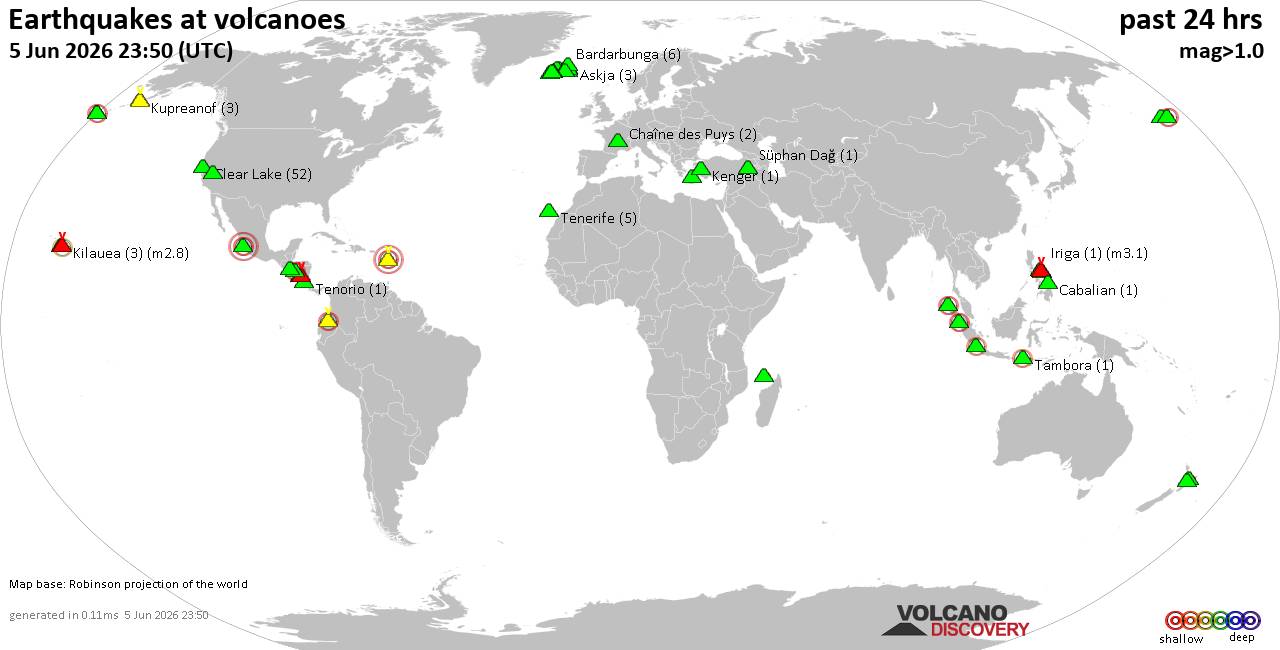 World map showing volcanoes with shallow (less than 50 km) earthquakes within 20 km radius during the past 24 hours on 5 Jun 2026 Number in brackets indicate nr of quakes. Quakes detected near: Askja (3 quakes between mag 0.7-1.0), Bardarbunga (6 quakes between mag 0.0-1.0), Brennisteinsfjöll (9 quakes between mag 0.0-1.4), Cabalian (1 quake mag 1.8), Cerro Negro de Mayasquer (1 quake mag 2.9), Chaîne des Puys (2 quakes between mag 1.0-1.5)
Clear Lake (52 quakes between mag 0.2-1.8), Cleveland (3 quakes between mag 0.8-1.2), Colima (1 quake mag 3.2), Conchagüita (3 quakes between mag 2.3-2.7), Eldey (3 quakes between mag 0.6-1.5), Esjufjöll (2 quakes between mag 0.5-1.1), Gareloi (1 quake mag 1.3), Geureudong (1 quake mag 2.1), Hengill (3 quakes between mag 0.1-1.7), Hrómundartindur (8 quakes between mag 0.1-1.1), Hulubelu (2 quakes between mag 2.0-2.0), Iriga (1 quake mag 3.1), Kenger (1 quake mag 1.4), Kilauea (3 quakes between mag 1.9-2.8), Kolumbo (1 quake mag 1.9), Krísuvík (5 quakes between mag 0.0-1.2), Kupreanof (3 quakes between mag 1.1-2.5), Kverkfjöll (1 quake mag 1.4), Langjökull (1 quake mag 1.3), Mammoth Mountain (2 quakes between mag 0.9-1.6), Masaya (1 quake mag 2.0), Maunaloa (3 quakes between mag 1.8-2.2), Mayon (2 quakes between mag 3.1-4.1), Mayotte Island (2 quakes between mag 0.6-1.9), Moffett (5 quakes between mag 0.8-2.5), Nejapa-Miraflores (1 quake mag 3.0), Pocdol Mountains (2 quakes between mag 3.0-5.3), Prestahnukur (113 quakes between mag 0.0-2.8), Reporoa (1 quake mag 1.8), San Salvador (1 quake mag 3.0), Sorikmarapi (2 quakes between mag 2.9-3.9), Soufrière de Guadeloupe (1 quake mag 3.0), Stepovak Bay 4 (1 quake mag 1.9), Süphan Dağ (1 quake mag 1.1), Tambora (1 quake mag 2.0), Tana (4 quakes between mag 0.3-2.1), Taupo (2 quakes between mag 2.0-2.0), Tenerife (5 quakes between mag 0.4-1.3), Tenorio (1 quake mag 1.0), Theistareykjarbunga (1 quake mag 1.4), Thordarhyrna (4 quakes between mag 0.0-1.3) (updated 23h50)
Note: Earthquakes within 20 km from and at depths less than 50 km under active volcanoes are reported. The list is not complete because many volcanoes are not monitored and/or seismic data in high resolution is not available publicly.
Volcanoes with recent earthquakes above magnitude 2 or more than 10 quakes are listed below:
Cerro Negro de Mayasquer volcano (Colombia): magnitude 2.9 earthquakeA magnitude 2.9 earthquake occurred at the volcano 7 hours ago. The quake, which might be volcanic in origin, was located at a depth of 8.00 km depth at 12 km distance E from the volcano. Earthquake details: 2.9 quake 24 km west of Ipiales, Departamento de Narino, Colombia, Jun 5, 2026 11:56 am (GMT -5) (12 km E) All earthquakes at Cerro Negro de MayasquerClear Lake volcano (California): 52 earthquakes up to magnitude 1.8Possible earthquake swarm: 52 earthquakes occurred near (under) the volcano during 21 hours, the last being recorded quake 11 minutes ago. Hypocenter depths ranged between 14.49 and 0.13 km. Earthquake details: (only 5 largest) 1.8 quake Sonoma County, 14 mi southwest of Clearlake, Lake County, California, United States, Jun 4, 2026 07:59 pm (GMT -7) (15 km SSW) 1.7 quake Sonoma County, 13 mi southwest of Clearlake, Lake County, California, United States, Jun 5, 2026 08:20 am (GMT -7) (15 km SSW) 1.6 quake Sonoma County, 13 mi southwest of Clearlake, Lake County, California, United States, Jun 5, 2026 10:14 am (GMT -7) (17 km S) 1.4 quake 25 mi north of Santa Rosa, Sonoma County, California, United States, Jun 5, 2026 04:55 am (GMT -7) (19 km S) 1.4 quake 26 mi north of Santa Rosa, Sonoma County, California, United States, Jun 5, 2026 01:01 am (GMT -7) (18 km S) All earthquakes at Clear LakeColima volcano (Western & Central Mexico): magnitude 3.2 earthquakeA magnitude 3.2 earthquake occurred at the volcano 16 hours ago. The quake, which might be volcanic in origin, was located at a depth of 9.90 km depth at 3 km distance NE from the volcano. Earthquake details: 3.2 quake 24 km southwest of Ciudad Guzman, Estado de Jalisco, Mexico, Jun 5, 2026 01:24 am (GMT -6) (3 km NE) All earthquakes at ColimaConchagüita volcano (El Salvador): 3 earthquakes up to magnitude 2.73 earthquakes occurred near (under) the volcano during 1 hour 33 minutes, the last being recorded quake 17 hours ago. Hypocenter depths ranged between 7.00 and 4.00 km. Earthquake details: 2.7 quake North Pacific Ocean, 10.1 km southeast of La Union, El Salvador, Jun 5, 2026 12:38 am (GMT -6) (6 km N) 2.5 quake North Pacific Ocean, 11 km southeast of La Union, El Salvador, Jun 4, 2026 11:39 pm (GMT -6) (6 km N) 2.3 quake North Pacific Ocean, 10.5 km southeast of La Union, El Salvador, Jun 5, 2026 01:12 am (GMT -6) (6 km N) All earthquakes at ConchagüitaGeureudong volcano (Sumatra): magnitude 2.1 earthquakeA magnitude 2.1 earthquake occurred at the volcano 20 hours ago. The quake, which might be volcanic in origin, was located at a depth of 11.00 km depth at 6 km distance W from the volcano. Earthquake details: 2.1 quake Kabupaten Bener Meriah, 50 km south of Bireun, Indonesia, Jun 5, 2026 10:41 am (GMT +7) (6 km W) All earthquakes at GeureudongIriga volcano (Luzon Island): magnitude 3.1 earthquakeA magnitude 3.1 earthquake occurred at the volcano 10 hours ago. The quake, which might be volcanic in origin, was located at a depth of 1.00 km depth at 7 km distance ESE from the volcano. Earthquake details: 3.1 quake Philippine Sea, 10.2 km southwest of Batan Island, Philippines, Jun 5, 2026 10:09 pm (GMT +8) (7 km ESE) All earthquakes at IrigaKilauea volcano (Hawai'i (Big Island)): 3 earthquakes up to magnitude 2.83 earthquakes occurred near (under) the volcano during 18 hours, the last being recorded quake 5 hours ago. Hypocenter depths ranged between 31.12 and 1.61 km. Earthquake details: 2.8 quake 27 mi south of Hilo, Hawaii County, Hawaii, United States, Jun 4, 2026 07:28 pm (GMT -10) (19 km ESE) 2.3 quake 36 mi southwest of Hilo, Hawaii County, Hawaii, United States, Jun 5, 2026 08:26 am (GMT -10) (17 km SW) 1.9 quake 28 mi south of Hilo, Hawaii County, Hawaii, United States, Jun 4, 2026 02:35 pm (GMT -10) (12 km SE) All earthquakes at KilaueaKupreanof volcano (Alaska Peninsula): 3 earthquakes up to magnitude 2.53 earthquakes occurred near (under) the volcano during 8 hours, the last being recorded quake 13 hours ago. Hypocenter depths ranged between 9.02 and 6.40 km. Earthquake details: 2.5 quake Lake and Peninsula Borough, 53 mi northeast of Sand Point, Aleutians East Borough, Alaska, United States, Jun 5, 2026 02:59 am (GMT -8) (4 km SSE) 1.9 quake 51 mi northeast of Sand Point, Aleutians East Borough, Alaska, United States, Jun 4, 2026 06:49 pm (GMT -8) (5 km SW) 1.1 quake Lake and Peninsula Borough, 56 mi northeast of Sand Point, Aleutians East Borough, Alaska, United States, Jun 5, 2026 08:17 am (Universal Time) (6 km E) All earthquakes at KupreanofMaunaloa volcano (Hawai'i (Big Island)): 3 earthquakes up to magnitude 2.23 earthquakes occurred near (under) the volcano during 2 hours, the last being recorded quake 14 hours ago. Hypocenter depths ranged between 9.39 and 3.76 km. Earthquake details: 2.2 quake 33 mi southwest of Hilo, Hawaii County, Hawaii, United States, Jun 4, 2026 09:48 pm (GMT -10) (15 km ESE) 2.1 quake 18 mi west of Volcano, Hawaii County, Hawaii, United States, Jun 4, 2026 10:28 pm (GMT -10) (13 km SE) 1.8 quake 32 mi southwest of Hilo, Hawaii County, Hawaii, United States, Jun 5, 2026 12:13 am (GMT -10) (11 km E) All earthquakes at MaunaloaMayon volcano (Luzon Island): 2 earthquakes up to magnitude 4.12 earthquakes occurred near (under) the volcano during 47 minutes, the last being recorded quake 12 hours ago. Hypocenter depths ranged between 15.00 and 12.00 km. Earthquake details: 4.1 quake 15 km northeast of Legaspi, Province of Albay, Bicol, Philippines, Jun 5, 2026 07:22 pm (Manila time) (16 km E) 3.1 quake 15 km northeast of Legaspi, Province of Albay, Bicol, Philippines, Jun 5, 2026 08:09 pm (GMT +8) (15 km E) All earthquakes at MayonMoffett volcano (Aleutian Islands): 5 earthquakes up to magnitude 2.55 earthquakes occurred near (under) the volcano during 13 hours, the last being recorded quake 7 hours ago. Hypocenter depths ranged between 16.30 and 4.60 km. Earthquake details: 2.5 quake Bering Sea, 5.2 mi northeast of Adak Island, Aleutians West Census Area, Alaska, United States, Jun 5, 2026 08:15 am (GMT -9) (16 km SE) 2.3 quake Bering Sea, 6 mi northeast of Adak Island, Aleutians West Census Area, Alaska, United States, Jun 5, 2026 07:40 am (GMT -9) (15 km SE) 1.8 quake Bering Sea, 6.3 mi northeast of Adak Island, Aleutians West Census Area, Alaska, United States, Jun 5, 2026 01:14 am (GMT -9) (15 km SE) 1.5 quake Bering Sea, 6.9 mi northeast of Adak Island, Aleutians West Census Area, Alaska, United States, Jun 5, 2026 04:17 am (GMT -9) (14 km ESE) 0.8 quake Bering Sea, 5 mi north of Adak Island, Aleutians West Census Area, Alaska, United States, Jun 5, 2026 03:54 am (Universal Time) (13 km SE) All earthquakes at MoffettNejapa-Miraflores volcano (Nicaragua): magnitude 3.0 earthquakeA magnitude 3.0 earthquake occurred at the volcano 20 hours ago. The quake, which might be volcanic in origin, was located at a depth of 10.00 km depth at 5 km distance SSW from the volcano. Earthquake details: Reported seismic-like event (likely no quake): 12 km southwest of Managua, Departamento de Managua, Nicaragua, Jun 4, 2026 09:43 pm (GMT -6) (5 km SSW) All earthquakes at Nejapa-MirafloresPocdol Mountains volcano (Luzon Island): 2 earthquakes up to magnitude 5.32 earthquakes occurred near (under) the volcano during 3 hours, the last being recorded quake 7 hours ago. Hypocenter depths ranged between 10.00 and 1.00 km. Earthquake details: 5.3 quake 28 km northwest of Sorsogon, Province of Sorsogon, Bicol, Philippines, Jun 5, 2026 09:57 pm (Manila time) (19 km NW) 3.0 quake Philippine Sea, 10.6 km southwest of Batan Island, Philippines, Jun 6, 2026 12:54 am (GMT +8) (13 km N) All earthquakes at Pocdol MountainsPrestahnukur volcano (Iceland): 113 earthquakes up to magnitude 2.8Possible earthquake swarm: 113 earthquakes occurred near (under) the volcano during 23 hours, the last being recorded quake 36 minutes ago. Hypocenter depths ranged between 20.40 and 0.00 km. Earthquake details: (only 5 largest) 2.8 quake West, 71 km northeast of Reykjavik, Capital Region, Iceland, Jun 5, 2026 07:06 pm (Reykjavik time) (12 km WSW) 2.0 quake 16.2 km N of Skjaldbreið Jun 5, 2026 05:00 pm (Universal Time) (12 km WSW) 2.0 quake 11.5 km SSE of Húsafell Jun 5, 2026 08:04 am (Universal Time) (10 km W) 1.9 quake 15.3 km N of Skjaldbreið Jun 5, 2026 09:53 pm (Universal Time) (13 km WSW) 1.9 quake Iceland: 15.8 km SSE of Húsafell Jun 5, 2026 07:25 pm (Reykjavik time) (12 km WSW) All earthquakes at PrestahnukurSan Salvador volcano (El Salvador): magnitude 3.0 earthquakeA magnitude 3.0 earthquake occurred at the volcano 6 hours ago. The quake, which might be volcanic in origin, was located at a depth of 10.00 km depth at 6 km distance S from the volcano. Earthquake details: Reported seismic-like event (likely no quake): 10.6 km west of San Salvador, Departamento de San Salvador, El Salvador, Jun 5, 2026 12:03 pm (GMT -6) (6 km S) All earthquakes at San SalvadorSorikmarapi volcano (Sumatra): 2 earthquakes up to magnitude 3.92 earthquakes occurred near (under) the volcano during 62 seconds, the last being recorded quake 2 hours ago. Hypocenter depths ranged between 10.00 and 4.00 km. Earthquake details: 3.9 quake Kabupaten Mandailing Natal, North Sumatra, 128 km northwest of Bukittinggi, Indonesia, Jun 6, 2026 04:35 am (Jakarta time) (16 km SE) 2.9 quake Kabupaten Mandailing Natal, 99 km south of Padangsidempuan, Indonesia, Jun 6, 2026 04:34 am (GMT +7) (16 km S) All earthquakes at SorikmarapiSoufrière de Guadeloupe volcano (Caribbean): magnitude 3.0 earthquakeA magnitude 3.0 earthquake occurred at the volcano 17 hours ago. The quake, which might be volcanic in origin, was located at a depth of 10.00 km depth at 19 km distance N from the volcano. Earthquake details: Reported seismic-like event (likely no quake): 17 km west of Les Abymes, Guadeloupe, Jun 5, 2026 02:59 am (GMT -4) (19 km N) All earthquakes at Soufrière de GuadeloupeTana volcano (Aleutian Islands): 4 earthquakes up to magnitude 2.14 earthquakes occurred near (under) the volcano during 6 hours, the last being recorded quake 18 hours ago. Hypocenter depths ranged between 5.04 and 0.49 km. Earthquake details: 2.1 quake 38 mi west of Nikolski, Aleutians West Census Area, Alaska, United States, Jun 4, 2026 02:57 pm (GMT -9) (4 km N) 1.4 quake 41 mi west of Nikolski, Aleutians West Census Area, Alaska, United States, Jun 4, 2026 09:08 pm (GMT -9) (6 km NW) 1.1 quake 41 mi west of Nikolski, Aleutians West Census Area, Alaska, United States, Jun 5, 2026 12:36 am (Universal Time) (5 km WNW) 0.3 quake 41 mi west of Nikolski, Aleutians West Census Area, Alaska, United States, Jun 5, 2026 12:37 am (Universal Time) (5 km WNW) All earthquakes at Tanahttps://www.volcanodiscovery.com/earthquakes-volcanoes/news/304198/Volcano-earthquake-report-for-Friday-5-Jun-2026.html
|
|


CMS The Best Conveyancing solicitors conveyancing quotes throughout the UK
For any webhosting enquiries please email webmaster@aus-city.com
|
|
Forums60
Topics792,785
Posts827,567
Members2,960
| |
Most Online102,106
Jul 10th, 2026
|
|
|
|
|
Copyright 1996 - 2026 by David Cottle. Designed by David Bate Jr. All Rights Reserved.
By using this forum, the user agrees not to transfer any data or technical information received under this agreement to any other entity without the express approval of the AUS-CITY Forum Admins and/or authors of individual posts (Forum Admins and DoD/USSPACECOM for the analysis of satellite tracking data).
Two-line elements (TLE) and all other satellite data presented and distributed via this forum and AUS-CITY mailing lists are distributed with permission from DoD/USSTRATCOM.

|

|


 - Click image for larger picture.")


