|
|
|
0 members (),
1,997
guests, and
27
robots. |
|
Key:
Admin,
Global Mod,
Mod
|
|
S |
M |
T |
W |
T |
F |
S |
|
|
1
|
2
|
3
|
4
|
5
|
6
|
|
7
|
8
|
9
|
10
|
11
|
12
|
13
|
|
14
|
15
|
16
|
17
|
18
|
19
|
20
|
|
21
|
22
|
23
|
24
|
25
|
26
|
27
|
|
28
|
29
|
30
|
|
|
|
|

World Earthquake Report for Saturday, 13 June 2026
• Moderate mag. 4.0 earthquake - 12 km south of Baukau, Baucau, Timor-Leste, ...
• Volcano earthquake report for Saturday, 13 Jun 2026
• Moderate mag. 4.1 earthquake - Indian Ocean, 149 km south of Yogyakarta, In...
• Moderate mag. 4.3 earthquake - Provincia de Cardenal Caro, Region del Liber...
• Moderate mag. 4.0 earthquake - 29 km southwest of Huetamo de Nunez, Estado ...
|
|
|
Joined: Feb 2001
Posts: 678,976
Launch Director
|
OP

Launch Director
Joined: Feb 2001
Posts: 678,976 |
Magnitude 2.9 earthquake strikes near Kailua-Kona, Hawaii County, Hawaii, USA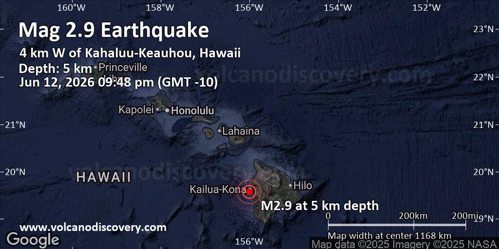 An earthquake of magnitude 2.9 occurred in the evening on Friday, June 12th, 2026, at 9:48 pm local time near Kailua-Kona, Hawaii County, Hawaii, USA, as reported by the United States Geological Survey.
According to preliminary data, the quake was located at a very shallow depth of 2.9 miles. Shallow earthquakes are felt more strongly than deeper ones as they are closer to the surface. The exact magnitude, epicenter, and depth of the quake might be revised within the next few hours or minutes as seismologists review data and refine their calculations, or as other agencies issue their report.
Our monitoring service identified a second report from the European-Mediterranean Seismological Centre (EMSC) which listed the quake at magnitude 3.0.
Based on the preliminary seismic data, the quake should not have caused any significant damage, but was probably felt by many people as light vibration in the area of the epicenter.
Weak shaking might have been felt in Kahaluu-Keauhou (pop. 3,500) located 3 miles from the epicenter.
Other towns or cities near the epicenter where the quake might have been felt as very weak shaking include Kailua-Kona (pop. 12,000) located 5 miles from the epicenter, Honalo (pop. 2,400) 5 miles away, Holualoa (pop. 8,500) 5 miles away, Kealakekua (pop. 2,000) 6 miles away, Captain Cook (pop. 3,400) 7 miles away, Kalaoa (pop. 9,600) 11 miles away, and Kalaoa (pop. 9,600) 11 miles away.
Earthquake data: Date & time: Jun 12, 2026 09:48 pm (GMT -10) local time (13 Jun 2026 07:48 GMT)Magnitude: 2.9 Depth: 4.64 km Epicenter latitude / longitude: 19.57°N / 156.01°W  (Hawaii, Hawaii, United States) Primary data source: USGShttps://www.volcanodiscovery.com/earthquake/news/305317/Magnitude-29-earthquake-strikes-near-Kailua-Kona-Hawaii-County-Hawaii-USA.html
|
|


CMS The Best Conveyancing solicitors conveyancing quotes throughout the UK
For any webhosting enquiries please email webmaster@aus-city.com
|
|
Forums60
Topics781,627
Posts816,385
Members2,960
| |
Most Online22,463
May 9th, 2026
|
|
|
|
|
Copyright 1996 - 2026 by David Cottle. Designed by David Bate Jr. All Rights Reserved.
By using this forum, the user agrees not to transfer any data or technical information received under this agreement to any other entity without the express approval of the AUS-CITY Forum Admins and/or authors of individual posts (Forum Admins and DoD/USSPACECOM for the analysis of satellite tracking data).
Two-line elements (TLE) and all other satellite data presented and distributed via this forum and AUS-CITY mailing lists are distributed with permission from DoD/USSTRATCOM.

|

|


 - Click image for larger picture.")


