|
0 members (),
1,730
guests, and
20
robots. |
|
Key:
Admin,
Global Mod,
Mod
|
|
S |
M |
T |
W |
T |
F |
S |
|
|
|
|
1
|
2
|
3
|
4
|
|
5
|
6
|
7
|
8
|
9
|
10
|
11
|
|
12
|
13
|
14
|
15
|
16
|
17
|
18
|
|
19
|
20
|
21
|
22
|
23
|
24
|
25
|
|
26
|
27
|
28
|
29
|
30
|
31
|
|
|
There are no members with birthdays on this day. |
|
|
|
|
|
|
|
|
by Webmaster - Sun 26 Jul 2026 08:45:PM
|
by Webmaster - Sun 26 Jul 2026 08:45:PM
|
by Webmaster - Sun 26 Jul 2026 08:45:PM
|
|
|
|
|
|
|
|
|
|
|
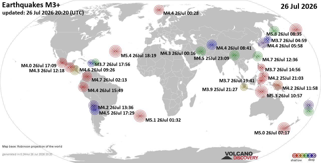
World Earthquake Report for Sunday, 26 July 2026
• Moderate mag. 4.5 earthquake - Estado de Veracruz-Llave, Mexico, on 2026-07...
• Volcano earthquake report for Sunday, 26 Jul 2026
• Moderate mag. 4.0 earthquake - Kabupaten Kepulauan Talaud, 148 km northeast...
• Light mag. 3.9 earthquake - North Pacific Ocean, 65 km south of Puerto San ...
• Strong mag. 5.4 earthquake - Northern Mid-Atlantic Ridge on Sunday, Jul 26,...
|

#823698
Mon 06 Jul 2026 07:08:PM
|
Joined: Feb 2001
Posts: 678,976
Launch Director
|
OP

Launch Director
Joined: Feb 2001
Posts: 678,976 |
SPC Day 2 Fire Weather OutlookSPC Day 2 Fire Weather Outlook 
Day 2 Fire Weather Outlook
NWS Storm Prediction Center Norman OK
0206 PM CDT Mon Jul 06 2026

Valid 071200Z - 081200Z

...Afternoon Update...
Only slight adjustments were made to the risk areas based on the
latest guidance. Notably, the Isolated Dry Thunderstorm risk area
was expanded into southern ID where a mix of wet/dry thunderstorms
will pose a risk for lightning ignitions where pockets of dry fuels
exist. Following dry thunderstorms on Day 1/Monday, dry and windy
conditions on Day 2/Tuesday may encourage possible lightning
holdovers to emerge east of the Cascades (south-central OR) into the
northern Sierra Nevada (northeast CA/northwest NV), and west-central
UT where Elevated highlights were maintained. The rest of the
forecast remains on track, see the previous discussion for more
information.

..Elizalde-Garcia.. 07/06/2026

.PREV DISCUSSION... /ISSUED 0206 AM CDT Mon Jul 06 2026/

...Synopsis...
Fire weather concerns will continue to be driven by a combination of
dry thunderstorm potential as well as dry/windy conditions across
portions of the West on Tuesday. A slight eastward shift of the
upper ridge from the Four Corners into the central Rockies is
expected through Tuesday evening. This will establish a more
west/southwest flow regime across the West Coast that will be
favorable for downslope flow off the northern Sierra Nevada and
portions of the Cascades. Additionally, a plume of mid-level
moisture will continue to spread east/northeast from the western
Great Basin towards the Four Corners/central Rockies that will
promote dry thunderstorm potential across a broad area.

...Dry Thunderstorms...
Mid-level moisture spreading eastward over the next 24 hours will
impinge on a plume of steep mid-level lapse rates and dry
boundary-layer conditions currently in place across the Four Corners
and central Rockies. This should promote adequate buoyancy for weak
convection by Tuesday afternoon. PWAT values are currently forecast
to range from 0.75 inches from the northern Great Basin to around
0.5 inch across UT and western CO. Forcing for ascent driven by weak
perturbations within the mean southwesterly flow regime over the
northern Great Basin should decrease eastward into the Four Corners
were orographic ascent will yield more isolated thunderstorms. This
will likely result in a mix of wet and dry thunderstorms across the
northern Great Basin with increasingly dry thunderstorms with
east/southeastward extent. Portions of central OR were removed from
the risk area owing to the potential for wetting rainfall over the
next 24 hours. However, portions of the area may be at risk for dry
lightning if rainfall amounts are more limited than currently
anticipated.

...Cascades into the northern Sierra Nevada...
The establishment of a southwest flow regime across the Cascades and
northern Sierra Nevada will promote strengthening downslope flow
along the eastern slopes. Latest forecast guidance suggests that the
driest and windiest conditions will emerge across northeast
CA/northwest NV where sustained winds between 15-20 mph will likely
coincide with 10-15% RH minimums. Further north, cooler conditions
will result in more sparse coverage of elevated conditions, but
favored gaps will likely see 15-20 mph winds with RH values falling
into the 15-25% range by late afternoon.

...Eastern Nevada into western Utah...
Another day of dry and windy conditions is expected for Tuesday as
weak troughing across the northern Great Basin drives an uptick in
southwesterly flow across the region. Confidence in 10-15% RH
minimums is fairly high given downslope trajectories off the
southern Sierra Nevada over the preceding 24 hours, and latest
HREF/REFS guidance suggests wind speeds will likely reach 15 mph for
many locations, resulting in a few hours of sustained elevated
conditions.

...Please see www.spc.noaa.gov/fire for graphic product...
Read morehttps://www.spc.noaa.gov/products/fire_wx/fwdy2.html
|
|



CMS The Best Conveyancing solicitors conveyancing quotes throughout the UK
For any webhosting enquiries please email webmaster@aus-city.com
|
|
Forums60
Topics792,808
Posts827,590
Members2,960
| |
Most Online102,106
Jul 10th, 2026
|
|
|





































