|
|
|
0 members (),
2,764
guests, and
25
robots. |
|
Key:
Admin,
Global Mod,
Mod
|
|
S |
M |
T |
W |
T |
F |
S |
|
|
|
|
|
1
|
2
|
3
|
|
4
|
5
|
6
|
7
|
8
|
9
|
10
|
|
11
|
12
|
13
|
14
|
15
|
16
|
17
|
|
18
|
19
|
20
|
21
|
22
|
23
|
24
|
|
25
|
26
|
27
|
28
|
29
|
30
|
31
|
|
There are no members with birthdays on this day. |
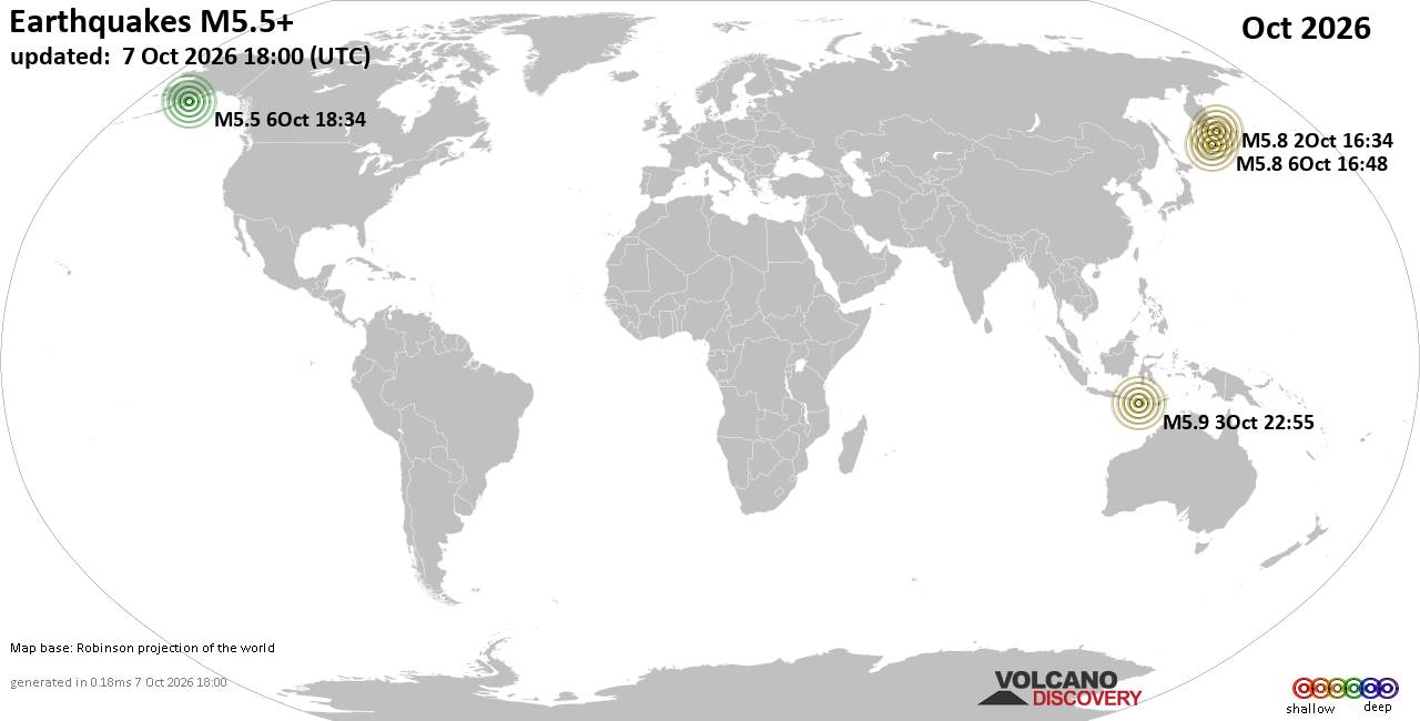
World Earthquake Report for October 2026
• M 1.3 - 57 km NW of Ninilchik, Alaska
• M 1.3 - 3 km ESE of Rose Lodge, Oregon
• M 2.1 - 6 km SSW of Pāhala, Hawaii
• M 1.5 - 27 km E of Honaunau-Napoopoo, Hawaii
• M 1.0 - 6 km WSW of Wilderness Rim, Washington
• M 3.0 - 23 km NE of Hydesville, CA
|

#835328
Wed 19 Aug 2026 07:09:PM
|
Joined: Feb 2001
Posts: 678,977
Launch Director
|
|
Launch Director
Joined: Feb 2001
Posts: 678,977 |
SPC Aug 19, 2026 1930 UTC Day 3 Severe Thunderstorm OutlookSPC 1930Z Day 3 Outlook 
Day 3 Convective Outlook
NWS Storm Prediction Center Norman OK
0208 PM CDT Wed Aug 19 2026

Valid 211200Z - 221200Z

...THERE IS A SLIGHT RISK OF SEVERE THUNDERSTORMS ACROSS PARTS OF
THE CENTRAL PLAINS...

...SUMMARY...
Isolated to scattered damaging hail (some greater than 2 inch
diamter) and severe wind gusts may occur over parts of the central
Plains late Friday afternoon and evening. Scattered storms, some
with severe wind gusts, are possible Friday afternoon over parts of
the Carolinas.

...Central Plains...

Northwest flow aloft will strengthen further on Friday, with 40-60
kt at 500 mb common across the Mid-MO Valley. At the surface, low
pressure will develop along surface troughing across western NE/KS.
Rich boundary-layer moisture will be in place across eastern NE/IA
and southward across the Lower MO Valley. A plume of steep midlevel
lapse rates will reside across the High Plains and spread eastward
toward the MO River during the evening. These steep lapse rates atop
the moist boundary layer will support a corridor of strong
instability (3000-4000 J/kg MLCAPE). Meanwhile, forecast soundings
indicate supercell wind profiles with nearly 50 kt effective shear
magnitudes and elongated/straight hodographs.

Initial supercells should develop near the surface trough over
southwest SD/northwest NE, and shift southeast through evening,
posing a risk for large to very large hail and damaging wind gusts.
Forecast guidance depicts a 40 kt southwesterly low-level jet
developing across KS overnight. This may maintain clusters/promote
upscale growth into an MCS during the nighttime hours, spreading
southeast toward northwest MO by Saturday morning. If this occurs,
damaging wind potential could increase/become the predominant severe
hazard overnight.

Additional more isolated storms could develop ahead of a
southward-advancing cold front across Iowa overnight. Any storms
that develop will likely be elevated, but will form in an
environment supporting severe hail.

...Southeast...

Scattered to numerous storms are forecast within a very moist and
unstable environment along a surface trough extending northeast to
southwest from NC into GA/southeast AL. Vertical shear is expected
to remain very weak. Nevertheless, a mix of single and multi-cell
convection will pose a risk for wet microbursts during the afternoon
and early evening.

..Leitman.. 08/19/2026
Read morehttps://www.spc.noaa.gov/products/outlook/day3otlk_1930.html
|
|



CMS The Best Conveyancing solicitors conveyancing quotes throughout the UK
For any webhosting enquiries please email webmaster@aus-city.com
|
|
Forums60
Topics875,107
Posts909,903
Members2,960
| |
Most Online102,106
Jul 10th, 2026
|
|
|
|
|

|









































