|
|
|
0 members (),
3,195
guests, and
16
robots. |
|
Key:
Admin,
Global Mod,
Mod
|
|
S |
M |
T |
W |
T |
F |
S |
|
1
|
2
|
3
|
4
|
5
|
6
|
7
|
|
8
|
9
|
10
|
11
|
12
|
13
|
14
|
|
15
|
16
|
17
|
18
|
19
|
20
|
21
|
|
22
|
23
|
24
|
25
|
26
|
27
|
28
|
|
29
|
30
|
|
|
|
|
|
|
There are no members with birthdays on this day. |
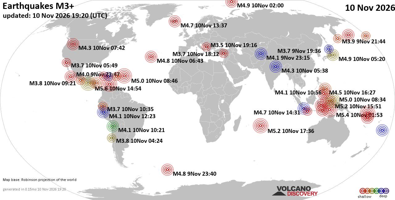
World Earthquake Report for Tuesday, 10 November 2026
• M 0.7 - 3 km SW of San Juan Bautista, CA
• Moderate mag. 4.1 earthquake - Philippine Sea, 52 km east of Siargao Island...
• M 1.3 - 15 km NNE of Milford, Utah
• M 2.0 - 37 km W of Petrolia, CA
• M 0.5 - 6 km SSW of Warner Springs, CA
• M 4.3 - 18 km SE of Joseph, Oregon
|

#902377
Fri 09 Oct 2026 11:50:AM
|
Joined: Feb 2001
Posts: 800,656
Launch Director
|
|
Launch Director
Joined: Feb 2001
Posts: 800,656 |
Volcano earthquake report for Friday, 9 October 2026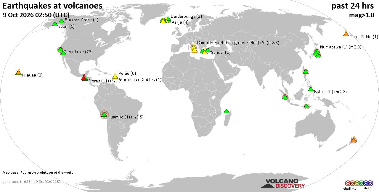 World map showing volcanoes with shallow (less than 50 km) earthquakes within 20 km radius during the past 24 hours on 9 Oct 2026 Number in brackets indicate nr of quakes. Quakes detected near: Askja (4 quakes between mag 0.1-1.2), Balut (8 quakes between mag 1.8-4.2), Bardarbunga (1 quake mag 1.0), Brennisteinsfjöll (1 quake mag 1.4), Buzzard Creek (1 quake mag 1.9), Campi Flegrei (Phlegrean Fields) (9 quakes between mag 0.1-2.8)
Clear Lake (26 quakes between mag 0.2-2.3), Coso (2 quakes between mag 1.1-1.3), Ebulobo (1 quake mag 2.3), Eldey (145 quakes between mag 0.0-3.4), Etna (1 quake mag 1.6), Eyafjallajökull (1 quake mag 1.1), Fagradalsfjall (1 quake mag 1.5), Fani Maoré (2 quakes between mag 1.4-3.1), Flores (10 quakes between mag 1.2-3.7), Great Sitkin (1 quake mag 1.0), Hrómundartindur (3 quakes between mag 0.0-1.0), Iraya (1 quake mag 2.4), Jan Mayen (1 quake mag 3.2), Katla (10 quakes between mag 0.2-2.8), Kilauea (1 quake mag 1.9), Kolumbo (3 quakes between mag 1.4-1.6), Kozushima (1 quake mag 2.2), Ljósufjöll (1 quake mag 1.5), Loihi (1 quake mag 2.0), Maunaloa (1 quake mag 2.4), Methana (1 quake mag 1.4), Mikura-jima (1 quake mag 2.5), Nii-jima (1 quake mag 2.6), Santorini (1 quake mag 1.6), Snaefellsjökull (1 quake mag 2.2), Spurr (1 quake mag 1.1), Svartsengi (9 quakes between mag 0.0-1.7), Talang (1 quake mag 2.9), Tjörnes Fracture Zone (1 quake mag 1.3), Torfajökull (4 quakes between mag 0.6-1.4), Vulcano (1 quake mag 1.1), Öraefajökull (3 quakes between mag 0.1-1.1) (updated 11h50)\n\nNote: Earthquakes within 20 km from and at depths less than 50 km under active volcanoes are reported. The list is not complete because many volcanoes are not monitored and/or seismic data in high resolution is not available publicly.\n
Volcanoes with recent earthquakes above magnitude 2 or more than 10 quakes are listed below:
Balut volcano (Mindanao): 8 earthquakes up to magnitude 4.28 earthquakes occurred near (under) the volcano during 6 hours, the last being recorded quake 14 hours ago. Hypocenter depths ranged between 31.00 and 10.00 km. Earthquake details: (only 5 largest) 4.2 quake Mindanao, Philippines, Oct 9, 2026 03:44 am (Manila time) (15 km N) 2.3 quake Philippines: 018 km S 30° W of Balut Island (Municipality of Sarangani) (Davao Occidental) Oct 9, 2026 03:13 am (GMT +8) (15 km SSW) 2.3 quake 003 km N 25° E of Balut Island (Municipality of Sarangani) (Davao Occidental) Oct 9, 2026 12:18 am (GMT +8) (8 km NE) 2.0 quake 002 km N 27° E of Balut Island (Municipality of Sarangani) (Davao Occidental) Oct 9, 2026 01:27 am (GMT +8) (7 km ENE) 2.0 quake 018 km S 21° W of Balut Island (Municipality of Sarangani) (Davao Occidental) Oct 9, 2026 12:20 am (GMT +8) (15 km S) All earthquakes at BalutBalut is an 840 m island stratovolcano south of Mindanao whose last known eruption occurred between about 2 million and 11,700 years ago. Hot springs and thermally altered ground occur on its western and southwestern flanks. Campi Flegrei (Phlegrean Fields) volcano (Italy): 9 earthquakes up to magnitude 2.89 earthquakes occurred near (under) the volcano during 17 hours, the last being recorded quake 3 hours ago. Hypocenter depths ranged between 3.71 and 0.01 km. Earthquake details: (only 5 largest) 2.8 quake Southern Italy Oct 8, 2026 11:41 pm (Rome time) (5 km W) 0.3 quake Italy: Flegrei Oct 9, 2026 09:12 am (Universal Time) (0 km NW) 0.2 quake Italy: Flegrei Oct 8, 2026 04:06 pm (Universal Time) (1 km E) 0.1 quake Italy: Flegrei Oct 9, 2026 07:13 am (Universal Time) (6 km SSW) 0.1 quake Italy: Flegrei Oct 9, 2026 03:41 am (Universal Time) (16 km S) All earthquakes at Campi Flegrei (Phlegrean Fields)Campi Flegrei is a 13-km-wide volcanic caldera encompassing part of Naples and the Gulf of Pozzuoli. Its last known eruption formed the Monte Nuovo cone in 1538. Clear Lake volcano (California): 26 earthquakes up to magnitude 2.3Possible earthquake swarm: 26 earthquakes occurred near (under) the volcano during 19 hours, the last being recorded quake 2 hours ago. Hypocenter depths ranged between 3.60 and 1.09 km. Earthquake details: (only 5 largest) 2.3 quake 7 km NW of the Geysers, CA, Oct 8, 2026 05:04 pm (GMT -7) (18 km SSW) 2.0 quake 7 km NW of the Geysers, CA, Oct 8, 2026 07:24 pm (GMT -7) (17 km S) 1.8 quake 7 km NW of the Geysers, CA, Oct 8, 2026 05:17 pm (GMT -7) (18 km SSW) 1.5 quake 6 km NW of the Geysers, CA, Oct 8, 2026 09:56 pm (GMT -7) (18 km SSW) 1.4 quake 5 km NW of the Geysers, CA, Oct 8, 2026 08:03 am (GMT -7) (17 km S) All earthquakes at Clear LakeEbulobo volcano (Flores): magnitude 2.3 earthquakeA magnitude 2.3 earthquake occurred at the volcano 17 hours ago. The quake, which might be volcanic in origin, was located at a depth of 34.00 km depth at 19 km distance SE from the volcano. Earthquake details: 2.3 quake Flores Region, Indonesia, Oct 9, 2026 02:44 am (GMT +8) (19 km SE) All earthquakes at EbuloboEbulobo is a 2,096 m stratovolcano in central Flores, Indonesia. Seven confirmed eruptive periods are recorded between 1830 and 1969, while an ash plume in 2017 was classified as an uncertain eruption. Eldey volcano (Iceland): 145 earthquakes up to magnitude 3.4Possible earthquake swarm: 145 earthquakes occurred near (under) the volcano during 18 hours, the last being recorded quake 1 hour 42 minutes ago. Hypocenter depths ranged between 18.90 and 0.00 km. Earthquake details: (only 5 largest) 3.4 quake Iceland Region Oct 8, 2026 05:50 pm (Reykjavik time) (14 km W) 3.0 quake Iceland Region Oct 9, 2026 04:00 am (Reykjavik time) (16 km W) 2.7 quake 2.2 km NNE of Geirfugladrangur Oct 8, 2026 08:38 pm (Universal Time) (14 km WSW) 2.6 quake Iceland: 2.2 km NNW of Geirfugladrangur Oct 8, 2026 10:12 pm (Reykjavik time) (16 km WSW) 2.6 quake Iceland: 5.8 km N of Geirfugladrangur Oct 8, 2026 08:18 pm (Reykjavik time) (15 km W) All earthquakes at EldeyEldey is a mostly submarine volcanic system south of Iceland, with only an island and several rocky skerries above water. Five eruptions are confirmed from 1211 to 1926, and an additional event in 1884 is uncertain. Fani Maoré volcano (Indian Ocean): 2 earthquakes up to magnitude 3.12 earthquakes occurred near (under) the volcano during 19 hours, the last being recorded quake 3 hours ago. Hypocenter depths ranged between 39.16 and 37.10 km. Earthquake details: 3.1 quake Event of Magnitude 3.1, Near Mamoudzou, Oct 8, 2026 03:56 pm (GMT +3) (12 km NW) 1.4 quake Event of Magnitude 1.4, Near Mamoudzou, Oct 9, 2026 08:25 am (Universal Time) (13 km NNW) All earthquakes at Fani MaoréFani Maoré is a submarine volcano about 50 km east of Mayotte. Seismic unrest began in May 2018, and surveys in 2019 discovered a new 800-m-high cone and extensive lava flows on the seafloor. Flores volcano (Guatemala): 10 earthquakes up to magnitude 3.710 earthquakes occurred near (under) the volcano during 17 hours, the last being recorded quake 7 hours ago. Hypocenter depths ranged between 10.00 and 1.40 km. Earthquake details: (only 5 largest) 3.7 quake Guatemala Oct 8, 2026 12:14 pm (Guatemala time) (14 km WNW) 3.6 quake Guatemala Oct 8, 2026 06:14 am (Guatemala time) (15 km NW) 3.2 quake Guatemala Oct 8, 2026 01:53 pm (Guatemala time) (14 km WNW) 2.9 quake Guatemala Oct 8, 2026 06:16 am (Guatemala time) (14 km WNW) 2.5 quake Guatemala Oct 8, 2026 10:57 pm (GMT -6) (13 km NW) All earthquakes at FloresFlores, also known as Volcán Amayo, is a volcanic field about 10 km west of Jutiapa in southeastern Guatemala. Its last eruption is undated, and none are known from approximately the past 11,700 years. Iraya volcano (North of Luzon): magnitude 2.4 earthquakeA magnitude 2.4 earthquake occurred at the volcano 10 hours ago. The quake, which might be volcanic in origin, was located at a depth of 32.00 km depth at 8 km distance SSE from the volcano. Earthquake details: 2.4 quake Philippines: 009 km S 55° E of Basco (Batanes) Oct 9, 2026 09:58 am (GMT +8) (8 km SSE) All earthquakes at IrayaJan Mayen volcano (Atlantic Ocean): magnitude 3.2 earthquakeA magnitude 3.2 earthquake occurred at the volcano 21 hours ago. The quake, which might be volcanic in origin, was located at a depth of 17.10 km depth at 18 km distance NW from the volcano. Earthquake details: 3.2 quake Jan Mayen Island Region Oct 8, 2026 04:49 pm (GMT +2) (18 km NW) All earthquakes at Jan MayenJan Mayen is a remote Norwegian volcanic island dominated by the glacier-covered Beerenberg stratovolcano. Its documented eruptions include lava-producing activity in 1970 and 1985, when flows reached the sea. Katla volcano (Iceland): 10 earthquakes up to magnitude 2.810 earthquakes occurred near (under) the volcano during 10 hours, the last being recorded quake 2 hours ago. Hypocenter depths ranged between 5.20 and 0.00 km. Earthquake details: (only 5 largest) 2.8 quake Iceland: 6.6 km ENE of Goðabunga Oct 9, 2026 02:23 am (Reykjavik time) (5 km NW) 1.8 quake Iceland: 3.1 km NW of Hábunga Oct 9, 2026 08:01 am (Reykjavik time) (5 km SW) 1.6 quake 2.6 km NNW of Hábunga Oct 9, 2026 08:08 am (Universal Time) (5 km SW) 1.2 quake Iceland: 6.6 km ENE of Goðabunga Oct 9, 2026 02:23 am (Reykjavik time) (5 km NW) 1.1 quake Iceland: 7.7 km NNE of Hábunga Oct 8, 2026 11:02 pm (Reykjavik time) (2 km NNW) All earthquakes at KatlaKozushima volcano (Izu Islands): magnitude 2.2 earthquakeA magnitude 2.2 earthquake occurred at the volcano 20 hours ago. The quake, which might be volcanic in origin, was located at a depth of 10.00 km depth at 5 km distance ESE from the volcano. Earthquake details: 2.2 quake Near South Coast of Honshu, Japan, Oct 9, 2026 12:31 am (GMT +9) (5 km ESE) All earthquakes at KozushimaKozushima is a Japanese island formed by 18 rhyolitic lava domes. Its last known eruption was a major explosive and effusive event in 838 CE that created the central Tenjosan dome. Maunaloa volcano (Hawai'i (Big Island)): magnitude 2.4 earthquakeA magnitude 2.4 earthquake occurred at the volcano 5 hours ago. The quake, which might be volcanic in origin, was located at a depth of 9.88 km depth at 16 km distance NW from the volcano. Earthquake details: 2.4 quake 22 km NE of Honaunau-Napoopoo, Hawaii, Oct 8, 2026 08:27 pm (GMT -10) (16 km NW) All earthquakes at MaunaloaMaunaloa is a huge, frequently active shield volcano on Hawaiʻi’s Big Island. Its predominantly lava-producing eruptions include a well-documented episode in November–December 2022. Mikura-jima volcano (Izu Islands): magnitude 2.5 earthquakeA magnitude 2.5 earthquake occurred at the volcano 9 hours ago. The quake, which might be volcanic in origin, was located at a depth of 30.00 km depth at 15 km distance E from the volcano. Earthquake details: 2.5 quake Japan: Far S Off Boso Peninsula Oct 9, 2026 11:48 am (GMT +9) (15 km E) All earthquakes at Mikura-jimaMikura-jima is a steep, 851 m-high volcanic island with a summit at Oyama and lava domes on its southeastern side. Its last known eruption occurred around 4100 BCE and involved explosive and effusive activity. Nii-jima volcano (Izu Islands): magnitude 2.6 earthquakeA magnitude 2.6 earthquake occurred at the volcano 3 hours ago. The quake, which might be volcanic in origin, was located at a depth of 30.00 km depth at 9 km distance WSW from the volcano. Earthquake details: 2.6 quake Japan: Near Niijima Island Oct 9, 2026 05:28 pm (GMT +9) (9 km WSW) All earthquakes at Nii-jimaNii-jima is a rhyolitic volcanic island in Japan’s Izu Volcanic Arc. Its last known eruption, at Mukai-yama in 886 CE, combined explosive activity with lava-dome formation. Snaefellsjökull volcano (Iceland): magnitude 2.2 earthquakeA magnitude 2.2 earthquake occurred at the volcano 20 hours ago. The quake, which might be volcanic in origin, was located at a depth of 6.20 km depth at 12 km distance NNW from the volcano. Earthquake details: 2.2 quake 2.0 km S of Hellissandur Oct 8, 2026 04:12 pm (Universal Time) (12 km NNW) All earthquakes at SnaefellsjökullSnaefellsjökull is an ice-covered stratovolcano in western Iceland with evidence of ten eruptive periods since about 8460 BCE. Its last dated eruption occurred around 200 CE, though some lava flows may be younger. Talang volcano (Sumatra): magnitude 2.9 earthquakeA magnitude 2.9 earthquake occurred at the volcano 13 hours ago. The quake, which might be volcanic in origin, was located at a depth of 10.00 km depth at 12 km distance N from the volcano. Earthquake details: 2.9 quake Southern Sumatra, Indonesia, Oct 9, 2026 05:28 am (Jakarta time) (12 km N) All earthquakes at TalangTalang is an Indonesian stratovolcano whose recorded eruptions have mainly been small-to-moderate explosions from flank craters. Its April 2005 eruption prompted 25,150 evacuations, and its last known eruptions occurred in 2007. https://www.volcanodiscovery.com/earthquakes-volcanoes/news/374393/Volcano-earthquake-report-2026-10-09.html
|
|



CMS The Best Conveyancing solicitors conveyancing quotes throughout the UK
For any webhosting enquiries please email webmaster@aus-city.com
|
|
Forums60
Topics920,725
Posts955,522
Members2,960
| |
Most Online102,106
Jul 10th, 2026
|
|
|
|
|

|









































