|
0 members (),
1,154
guests, and
25
robots. |
|
Key:
Admin,
Global Mod,
Mod
|
|
S |
M |
T |
W |
T |
F |
S |
|
|
|
|
|
1
|
2
|
3
|
|
4
|
5
|
6
|
7
|
8
|
9
|
10
|
|
11
|
12
|
13
|
14
|
15
|
16
|
17
|
|
18
|
19
|
20
|
21
|
22
|
23
|
24
|
|
25
|
26
|
27
|
28
|
29
|
30
|
31
|
|
There are no members with birthdays on this day. |

M 5.0 - 81 km S of Sand Point, Alaska
• M 3.4 - 85 km ENE of Christiansted, U.S. Virgin Islands
• M 3.4 - 85 km ENE of Christiansted, U.S. Virgin Islands
• Strong mag. 5.7 earthquake - Qinghai, China, on Sunday, Oct 25, 2026, at 11...
• M 5.6 - 43 km NNW of Lake Minchumina, Alaska
• M 2.7 - 92 km SSW of Unalaska, Alaska
• M 3.1 - 55 km SSW of Nikolski, Alaska
|

#902967
Fri 09 Oct 2026 05:25:PM
|
Joined: Feb 2001
Posts: 678,977
Launch Director
|
|
Launch Director
Joined: Feb 2001
Posts: 678,977 |
SPC Tornado Watch 677WW 677 TORNADO AL FL GA CW 091720Z - 100100Z 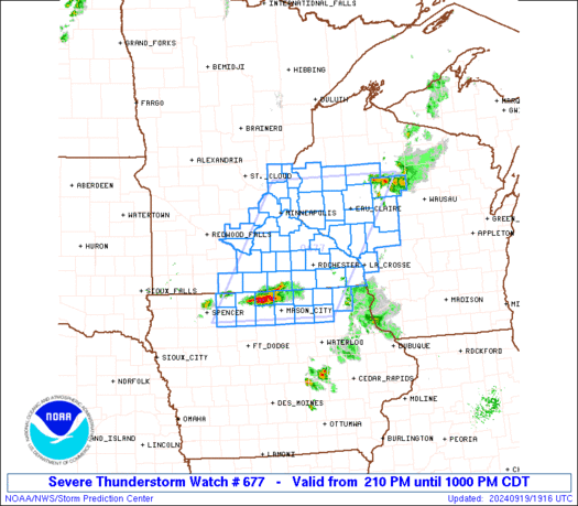
URGENT - IMMEDIATE BROADCAST REQUESTED
Tornado Watch Number 677
NWS Storm Prediction Center Norman OK
120 PM EDT Fri Oct 9 2026

The NWS Storm Prediction Center has issued a

* Tornado Watch for portions of
  Far Southeast Alabama
  Florida Panhandle and Big Bend
  Far Southwest Georgia
  Coastal Waters

* Effective this Friday afternoon and evening from 120 PM until
  900 PM EDT.

* Primary threats include...
  A few tornadoes likely

SUMMARY...Convective bands associated with Hurricane Isaias will
continue to move north and overspread the Watch area from south to
north.  Embedded cells within the bands will pose a risk for
tornadoes with the stronger mesocyclones as a moist maritime
tropical airmass moves inland through the afternoon and early
evening.

The tornado watch area is approximately along and 50 statute miles
north and south of a line from 25 miles west southwest of Crestview
FL to 30 miles north northeast of Cross City FL. For a complete
depiction of the watch see the associated watch outline update
(WOUS64 KWNS WOU7).

PRECAUTIONARY/PREPAREDNESS ACTIONS...

REMEMBER...A Tornado Watch means conditions are favorable for
tornadoes and severe thunderstorms in and close to the watch
area. Persons in these areas should be on the lookout for
threatening weather conditions and listen for later statements
and possible warnings.

&&

AVIATION...Tornadoes and a few severe thunderstorms with hail
surface and aloft to 0.5 inches. Extreme turbulence and surface wind
gusts to 50 knots. A few cumulonimbi with maximum tops to 550. Mean
storm motion vector 14030.

...Smith
Read morehttps://www.spc.noaa.gov/products/watch/ww0677.html
|
|



CMS The Best Conveyancing solicitors conveyancing quotes throughout the UK
For any webhosting enquiries please email webmaster@aus-city.com
|
|
Forums60
Topics893,242
Posts928,039
Members2,960
| |
Most Online102,106
Jul 10th, 2026
|
|
|









































