|
|
|
0 members (),
1,802
guests, and
27
robots. |
|
Key:
Admin,
Global Mod,
Mod
|
|
S |
M |
T |
W |
T |
F |
S |
|
|
|
|
|
1
|
2
|
3
|
|
4
|
5
|
6
|
7
|
8
|
9
|
10
|
|
11
|
12
|
13
|
14
|
15
|
16
|
17
|
|
18
|
19
|
20
|
21
|
22
|
23
|
24
|
|
25
|
26
|
27
|
28
|
29
|
30
|
31
|
|
There are no members with birthdays on this day. |
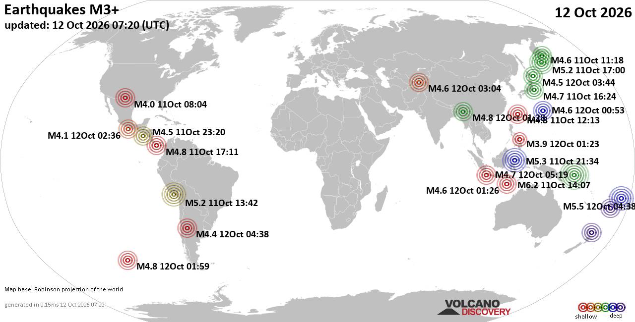
World Earthquake Report for Monday, 12 October 2026
• M 2.2 - 16 km ESE of Pearsall, Texas
• M 2.5 - 63 km SSE of Perryville, Alaska
• M 5.5 - 122 km W of Neiafu, Tonga
• M 2.0 - 10 km W of Boonville, CA
• M 1.8 - 9 km SSW of Pāhala, Hawaii
|
|
|
Joined: Feb 2001
Posts: 678,977
Launch Director
|
|
Launch Director
Joined: Feb 2001
Posts: 678,977 |
SPC Oct 12, 2026 0730 UTC Day 3 Severe Thunderstorm OutlookSPC 0730Z Day 3 Outlook 
Day 3 Convective Outlook
NWS Storm Prediction Center Norman OK
0221 AM CDT Mon Oct 12 2026

Valid 141200Z - 151200Z

...THERE IS A MARGINAL RISK OF SEVERE THUNDERSTORMS ACROSS PORTIONS
OF THE CENTRAL AND SOUTHERN PLAINS INTO THE OZARK PLATEAU...

...SUMMARY...
Isolated severe thunderstorms are possible across portions of the
central and southern Plains into the Ozark Plateau Wednesday
afternoon and evening.

...Synopsis...

An upper low centered over UT and AZ Wednesday morning is forecast
to advance into CO while an embedded vorticity maximum pivots
through the basal portion of the low into the southern Rockies and
adjacent High Plains by Wednesday evening. Modest height falls and
strengthening midlevel flow will precede that disturbance, spreading
into the southern and central High Plains Wednesday afternoon and
evening. At the surface, a cold front will settle south through the
Mid-Atlantic and OH Valley. The position of the front over the
central and southern Plains will likely be modulated by ongoing
showers and thunderstorms Wednesday morning.


...Central and Southern Plains into the Ozark Plateau...

As mentioned above, considerable shower and thunderstorm activity is
expected to be ongoing at 12z Wednesday along and south of the
synoptic front. The presence of a seasonably moist and minimally
capped warm sector will likely allow thunderstorms to continue
through the forecast period, especially as forcing for ascent
increases Wednesday afternoon into evening. Corridors of moderate
instability appear possible by afternoon to the south of any more
persistent clouds and precipitation with associated outflow
boundaries potentially serving as foci for strong to potentially
severe storm development during the afternoon and evening.

Latest model guidance suggests that the strongest vertical shear may
reside across a convectively overturned air mass closer to the
synoptic front with decreasing shear magnitudes with southward
extent where greater instability is more probable. Given these
potential issues/uncertainties, only level-1/Marginal Risk
probabilities will be included in this forecast.


...Ohio Valley into the Mid-Atlantic...

Convective evolution on this segment of the cold front remains more
uncertain due to the absence of any appreciable forcing mechanisms
in 00Z model data. Nonetheless, a moist boundary layer will reside
to the south of the front, supporting pockets of moderate
instability in areas that experience stronger daytime heating. A
strong storm or two appears possible along the front during the
afternoon and evening hours with a risk for locally gusty winds. The
area will be reevaluated in subsequent outlooks for the possible
inclusion of severe weather probabilities.

..Mead.. 10/12/2026
Read morehttps://www.spc.noaa.gov/products/outlook/day3otlk_0730.html
|
|



CMS The Best Conveyancing solicitors conveyancing quotes throughout the UK
For any webhosting enquiries please email webmaster@aus-city.com
|
|
Forums60
Topics870,219
Posts905,015
Members2,960
| |
Most Online102,106
Jul 10th, 2026
|
|
|
|
|

|









































