|
1 members (Alisa),
1,511
guests, and
22
robots. |
|
Key:
Admin,
Global Mod,
Mod
|
|
S |
M |
T |
W |
T |
F |
S |
|
|
|
|
|
1
|
2
|
3
|
|
4
|
5
|
6
|
7
|
8
|
9
|
10
|
|
11
|
12
|
13
|
14
|
15
|
16
|
17
|
|
18
|
19
|
20
|
21
|
22
|
23
|
24
|
|
25
|
26
|
27
|
28
|
29
|
30
|
31
|
|
There are no members with birthdays on this day. |
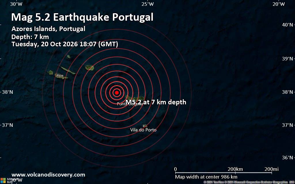
Magnitude 5.2 earthquake strikes near Ponta Delgada, Azores, Portugal
• Possible earthquake reported near Ponta Delgada, Azores, Portugal
• Strong mag. 5.2 earthquake - 10.2 km north of Ponta Delgada, Azores, Portug...
• Magnitude 2.3 quake hits 16 km southwest of Odawara, Japan, early morning
• M 0.4 - 7 km NW of The Geysers, CA
• M 1.9 - 21 km ENE of Denali Park, Alaska
|

#917531
Sun 18 Oct 2026 02:44:AM
|
Joined: Feb 2001
Posts: 678,977
Launch Director
|
|
Launch Director
Joined: Feb 2001
Posts: 678,977 |
Issued at 900 PM CST Sat Oct 17 2026 ZCZC MIATCDEP1 ALL
TTAA00 KNHC DDHHMM
Hurricane Trudy Discussion Number 19
NWS National Hurricane Center Miami FL EP212026
900 PM CST Sat Oct 17 2026
Over the last several hours the convection in the inner core of the
cyclone has warmed slightly, though there are occasional hints of a
ragged eye. Looking at the most recent microwave data, Trudy
appears to be affected by some southwesterly shear, given the
northeastward tilt with height in the latest WSF-M pass. The
initial intensity for the cyclone is being held at 85 kt based on
a combination of recent objective and subjective estimates, and
the initial position is adjusted somewhat to the west based on the
microwave data.
The hurricane is moving generally northwestward or 325 degrees/8
kt. The cyclone should continue to move in an overall northwestward
motion for the next 24-36 h as a weak low- to mid-level ridge
builds over eastern Mexico. This continued motion would bring Trudy
close to the coast of west-central Mexico overnight and Sunday.
Afterwards, the hurricane is expected to weaken and then
predominately be steered by low-level flow, which will result in a
turn toward the west-northwest away from the coast. As mentioned
before, the initial position has been adjusted farther west, thus
the NHC track forecast has been moved slightly west as well. The
current track forecast is still in good agreement with the HCCA and
GDMI forecast aids.
The environment around Trudy still supports some slight
strengthening through the night, but southwesterly shear is likely
to keep any strengthening limited. By midday Sunday, an increase
in southwesterly shear along with a decrease in mid-level relative
humidity will result in a rapid weakening for Trudy. This weakening
trend is expected to persist even as the cyclone moves away from
the Mexican coast, and the new NHC forecast is lower than the last
one. The current NHC intensity forecast has Trudy become
post-tropical around 72 h, however it is possible that the cyclone
could become post-tropical sooner based on the ECMWF simulated
satellite guidance.
KEY MESSAGES:
1. Trudy is forecast to strengthen as it moves near the coast of
southwestern and west-central Mexico tonight and Sunday. Damaging
hurricane-force winds are likely within the hurricane warning area.
2. A dangerous storm surge accompanied by damaging waves is likely
in areas of onshore winds within the warning areas.
3. Heavy rainfall associated with Trudy will impact the southwest
Mexican coast between Guerrero and Nayarit through the weekend. This
rainfall may produce life-threatening flooding and mudslides along
and near the southwest Mexican coast in Michoacán, Colima, and
Jalisco, especially in areas along steep terrain.
4. Large swells are affecting portions of the coast of southwestern
Mexico and will spread northward through the weekend, causing
life-threatening surf and rip current conditions.
FORECAST POSITIONS AND MAX WINDS
INIT 18/0300Z 18.2N 105.7W 85 KT 100 MPH
12H 18/1200Z 19.2N 106.4W 90 KT 105 MPH
24H 19/0000Z 20.1N 107.1W 75 KT 85 MPH
36H 19/1200Z 20.6N 107.7W 60 KT 70 MPH
48H 20/0000Z 20.9N 108.3W 50 KT 60 MPH
60H 20/1200Z 21.1N 108.7W 40 KT 45 MPH
72H 21/0000Z 21.5N 109.3W 30 KT 35 MPH...POST-TROP/REMNT LOW
96H 22/0000Z...DISSIPATED
$$
Forecaster Katz/Blake
NNNN Source: Hurricane Trudy Forecast Discussion Number 19
|
|



CMS The Best Conveyancing solicitors conveyancing quotes throughout the UK
For any webhosting enquiries please email webmaster@aus-city.com
|
|
Forums60
Topics885,285
Posts920,082
Members2,960
| |
Most Online102,106
Jul 10th, 2026
|
|
|









































