|
|
|
0 members (),
1,679
guests, and
24
robots. |
|
Key:
Admin,
Global Mod,
Mod
|
|
S |
M |
T |
W |
T |
F |
S |
|
|
|
|
|
1
|
2
|
3
|
|
4
|
5
|
6
|
7
|
8
|
9
|
10
|
|
11
|
12
|
13
|
14
|
15
|
16
|
17
|
|
18
|
19
|
20
|
21
|
22
|
23
|
24
|
|
25
|
26
|
27
|
28
|
29
|
30
|
31
|
|
There are no members with birthdays on this day. |
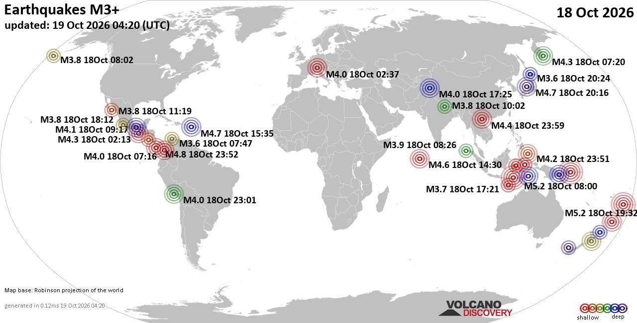
World Earthquake Report for Sunday, 18 October 2026
• M 1.1 - 9 km WNW of Cobb, CA
• M 4.5 - 2 km W of Lunca Jariștei, Romania
• M 1.3 - 11 km S of Joshua Tree, CA
• M 4.5 - 2 km W of Lunca Jariștei, Romania
• M 4.5 - 2 km W of Lunca Jariștei, Romania
• Strong mag. 5.1 earthquake - Offshore Vanuatu on 2026-10-19 20:25
|
|
|
Joined: Feb 2001
Posts: 678,977
Launch Director
|
|
Launch Director
Joined: Feb 2001
Posts: 678,977 |
SPC Oct 19, 2026 0730 UTC Day 3 Severe Thunderstorm OutlookSPC 0730Z Day 3 Outlook 
Day 3 Convective Outlook
NWS Storm Prediction Center Norman OK
0152 AM CDT Mon Oct 19 2026

Valid 211200Z - 221200Z

...THERE IS A MARGINAL RISK OF SEVERE THUNDERSTORMS ACROSS PORTIONS
OF CENTRAL AND EASTERN ARIZONA INTO FAR WESTERN NEW MEXICO...

...SUMMARY...
Isolated severe wind/hail and perhaps a brief tornado may occur over
portions of Arizona into western New Mexico on Wednesday.

...Synopsis...
An upper trough will continue to deepen while traversing the
Interior West on Wednesday, provoking a strong low-level mass
response across the Desert Southwest and Rockies into the High
Plains. Adequate low-level moisture will stream northward across CA
and the Interior West, beneath strong, nearly unidirectional
southwesterly flow aloft. At least scattered thunderstorms are
anticipated across much of the CONUS west of the Rockies. However,
the richest low-level moisture and associated buoyancy will reside
in the Lower Colorado River Basin, where an isolated severe threat
will exist.

...Lower Colorado River Basin...
Across the Lower Colorado River Basin, low to mid 50s F surface
dewpoints will advect northward beneath 6.5+ C/km mid-level lapse
rates and a 50-80 kt 500 mb jet streak. 500-1000 J/kg MLCAPE may
manifest amid large and elongated hodographs. These conditions would
support multicells and perhaps a few supercell structures with an
attendant isolated severe wind/hail threat and perhaps a brief
tornado, warranting the introduction of Category 1/Marginal Risk
probabilities this outlook.

...Central California Valley Region...
On Wednesday afternoon, a 70+ kt southerly 500 mb jet, as well as 7+
C/km mid-level lapse rates, will overspread central and southern CA
as the upper trough overspreads the San Joaquin Valley. The strong,
nearly unidirectional flow will yield slightly curved, but very
elongated hodographs. Such conditions would typically favor the
development of low-topped supercells. However, surface
temperatures/dewpoints in the upper 50s/mid 40s F may limit buoyancy
considerably, precluding severe probabilities this outlook.

..Squitieri.. 10/19/2026
Read morehttps://www.spc.noaa.gov/products/outlook/day3otlk_0730.html
|
|



CMS The Best Conveyancing solicitors conveyancing quotes throughout the UK
For any webhosting enquiries please email webmaster@aus-city.com
|
|
Forums60
Topics882,528
Posts917,325
Members2,960
| |
Most Online102,106
Jul 10th, 2026
|
|
|
|
|

|









































