|
|
|
0 members (),
2,467
guests, and
27
robots. |
|
Key:
Admin,
Global Mod,
Mod
|
|
S |
M |
T |
W |
T |
F |
S |
|
1
|
2
|
3
|
4
|
5
|
6
|
7
|
|
8
|
9
|
10
|
11
|
12
|
13
|
14
|
|
15
|
16
|
17
|
18
|
19
|
20
|
21
|
|
22
|
23
|
24
|
25
|
26
|
27
|
28
|
|
29
|
30
|
|
|
|
|
|
|
There are no members with birthdays on this day. |
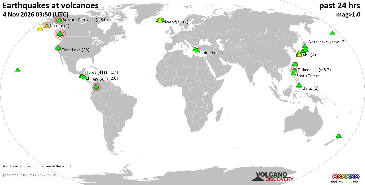
Volcano earthquake report for Wednesday, 4 November 2026
• M 3.0 - 55 km ENE of Pedro Bay, Alaska
• M 2.5 - 6 km NW of Pine Valley, CA
• M 0.9 - 5 km WNW of The Geysers, CA
• M 0.8 - 7 km SE of Lake Henshaw, CA
• M 2.2 - 19 km WNW of Ferndale, CA
|
|
|
Joined: Feb 2001
Posts: 678,977
Launch Director
|
|
Launch Director
Joined: Feb 2001
Posts: 678,977 |
SPC Nov 4, 2026 0830 UTC Day 3 Severe Thunderstorm OutlookSPC 0830Z Day 3 Outlook 
Day 3 Convective Outlook
NWS Storm Prediction Center Norman OK
0225 AM CST Wed Nov 04 2026

Valid 061200Z - 071200Z

...NO SEVERE THUNDERSTORM AREAS FORECAST...

...SUMMARY...
A few strong storms are possible Friday over parts of eastern North
Carolina and Virginia.

...Discussion...
On Friday, the southern lobe of the eastern trough will move rapidly
east from the Ohio and Tennessee Valleys and into the Mid Atlantic
by afternoon, with strong cooling aloft and increasing midlevel
winds over 60 kt. A surface trough will deepen a bit during the day
over the eastern Carolinas and Virginia, where mid 60s F dewpoints
will be in place.

Early day rain and thunderstorms will be possible, which may
mitigate destabilization somewhat. However, at least some diurnal
surface heating may occur upstream/south, with gradual warming and
further destabilization during the day via advection. Increasing
large-scale lift may support renewed development along the effective
outflow/baroclinic zone. Given increasing mean wind fields aloft and
favorable deep-layer shear, at least isolated damaging gusts may
occur.

Given the ongoing early day rain and some model discrepancy as to
effective frontal position, will defer possible low severe
probabilities to later updates.

..Jewell.. 11/04/2026
Read morehttps://www.spc.noaa.gov/products/outlook/day3otlk_0830.html
|
|



CMS The Best Conveyancing solicitors conveyancing quotes throughout the UK
For any webhosting enquiries please email webmaster@aus-city.com
|
|
Forums60
Topics910,568
Posts945,365
Members2,960
| |
Most Online102,106
Jul 10th, 2026
|
|
|
|
|

|









































