|
|
|
0 members (),
2,416
guests, and
26
robots. |
|
Key:
Admin,
Global Mod,
Mod
|
|
S |
M |
T |
W |
T |
F |
S |
|
1
|
2
|
3
|
4
|
5
|
6
|
7
|
|
8
|
9
|
10
|
11
|
12
|
13
|
14
|
|
15
|
16
|
17
|
18
|
19
|
20
|
21
|
|
22
|
23
|
24
|
25
|
26
|
27
|
28
|
|
29
|
30
|
|
|
|
|
|
|
There are no members with birthdays on this day. |
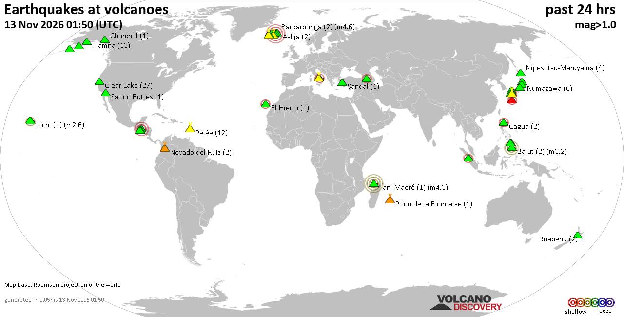
Volcano earthquake report for Friday, 13 November 2026
• M 3.4 - 54 km N of Kobuk, Alaska
• Moderate mag. 4.9 earthquake - Northern Mariana Islands: Mariana Islands on...
• M 1.6 - 28 km WSW of Salamatof, Alaska
• M -0.7 - 66 km ENE of Pedro Bay, Alaska
• M 0.6 - 89 km SE of Kokhanok, Alaska
• M 0.7 - 90 km SE of Kokhanok, Alaska
|
|
|
Joined: Feb 2001
Posts: 800,656
Launch Director
|
|
Launch Director
Joined: Feb 2001
Posts: 800,656 |
Issued at 500 PM HST Wed Nov 11 2026 000
WTPA34 PHFO 120234
TCPCP4
BULLETIN
Tropical Storm Pena Advisory Number 22
NWS Central Pacific Hurricane Center Honolulu HI CP042026
Issued by NWS National Hurricane Center Miami FL
500 PM HST Wed Nov 11 2026
...PENA CONTINUES WESTWARD WHILE PASSING WELL SOUTH OF JOHNSTON
ISLAND...
SUMMARY OF 500 PM HST...0300 UTC...INFORMATION
----------------------------------------------
LOCATION...9.8N 170.6W
ABOUT 480 MI...775 KM S OF JOHNSTON ISLAND
ABOUT 1160 MI...1865 KM SW OF HONOLULU HAWAII
MAXIMUM SUSTAINED WINDS...45 MPH...75 KM/H
PRESENT MOVEMENT...W OR 270 DEGREES AT 15 MPH...24 KM/H
MINIMUM CENTRAL PRESSURE...1002 MB...29.59 INCHES
WATCHES AND WARNINGS
--------------------
There are no coastal watches or warnings in effect.
DISCUSSION AND OUTLOOK
----------------------
At 500 PM HST (0300 UTC), the center of Tropical Storm Pena was
located near latitude 9.8 North, longitude 170.6 West. Pena is
moving toward the west near 15 mph (24 km/h), and this general
motion is expected for the next few days.
Maximum sustained winds are near 45 mph (75 km/h) with higher gusts.
Pena is forecast to begin weakening early Thursday and dissipate by
late Friday or early Saturday.
Tropical-storm-force winds extend outward up to 115 miles (185 km)
from the center.
The estimated minimum central pressure is 1002 mb (29.59 inches).
HAZARDS AFFECTING LAND
----------------------
None.
NEXT ADVISORY
-------------
Next complete advisory at 1100 PM HST.
$$
Forecaster Gibbs Source: Tropical Storm Pena Public Advisory Number 22
|
|



CMS The Best Conveyancing solicitors conveyancing quotes throughout the UK
For any webhosting enquiries please email webmaster@aus-city.com
|
|
Forums60
Topics925,284
Posts960,081
Members2,960
| |
Most Online102,106
Jul 10th, 2026
|
|
|
|
|

|









































