|
|
|
0 members (),
735
guests, and
22
robots. |
|
Key:
Admin,
Global Mod,
Mod
|
|
S |
M |
T |
W |
T |
F |
S |
|
|
|
1
|
2
|
3
|
4
|
5
|
|
6
|
7
|
8
|
9
|
10
|
11
|
12
|
|
13
|
14
|
15
|
16
|
17
|
18
|
19
|
|
20
|
21
|
22
|
23
|
24
|
25
|
26
|
|
27
|
28
|
29
|
30
|
31
|
|
|
|
There are no members with birthdays on this day. |
|
|
Joined: Feb 2001
Posts: 381,904
Launch Director
|
OP

Launch Director
Joined: Feb 2001
Posts: 381,904 |
Volcano earthquake report for Friday, 25 Jul 2025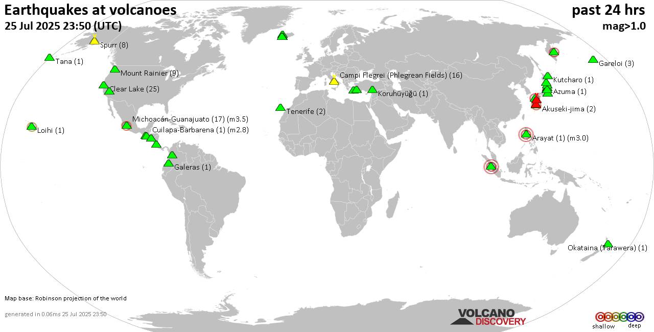 World map showing volcanoes with shallow (less than 50 km) earthquakes within 20 km radius during the past 24 hours on 25 Jul 2025 Number in brackets indicate nr of quakes. Quakes detected near: Agua (3 quakes between mag 1.9-3.5), Akuseki-jima (1 quake mag 2.1), Arenal (1 quake mag 2.0), Barva (1 quake mag 3.3), Campi Flegrei (Phlegrean Fields) (18 quakes between mag 0.1-3.0), Cerro Bravo (1 quake mag 1.8)
Clear Lake (15 quakes between mag 0.7-1.6), Coso (2 quakes between mag 0.2-1.0), Daisen (1 quake mag 1.3), El Chichón (5 quakes between mag 1.9-3.0), Gareloi (4 quakes between mag 1.7-2.8), Hrómundartindur (2 quakes between mag 0.4-1.3), Isla El Tigre (1 quake mag 3.5), Kolumbo (4 quakes between mag 1.3-2.0), Koruhüyüğü (1 quake mag 1.8), Krísuvík (2 quakes between mag 0.3-1.2), Ljósufjöll (5 quakes between mag 0.8-1.6), Mahagnao (1 quake mag 2.6), Michoacán-Guanajuato (9 quakes between mag 2.5-3.3), Mount Rainier (8 quakes between mag 0.1-1.0), Nantai (2 quakes between mag 0.6-1.1), Okataina (Tarawera) (1 quake mag 1.4), Osore-yama (3 quakes between mag 0.4-1.2), Papandayan (1 quake mag 2.5), Platanar (1 quake mag 1.8), Sanbe (2 quakes between mag 2.7-2.8), Spurr (11 quakes between mag 0.1-2.2), Suwanose-jima (3 quakes between mag 1.5-2.0), Talang (4 quakes between mag 2.5-3.2), Taupo (1 quake mag 1.0), To-shima (2 quakes between mag 1.0-1.2), Unzen (34 quakes between mag 0.2-2.9), Yellowstone (1 quake mag 3.0) (updated 08h50)
Note: Earthquakes within 20 km from and at depths less than 50 km under active volcanoes are reported. The list is not complete because many volcanoes are not monitored and/or seismic data in high resolution is not available publicly.
Volcanoes with recent earthquakes above magnitude 2 or more than 10 quakes are listed below:
Agua volcano (Guatemala): 3 earthquakes up to magnitude 3.53 earthquakes occurred near (under) the volcano during 1 hour 9 minutes, the last being recorded quake 6 hours ago. Hypocenter depths ranged between 10.00 and 6.00 km. Earthquake details: 3.5 quake Departamento de Sacatepequez, 20 km southwest of Guatemala City, Guatemala, Jul 24, 2025 07:11 pm (GMT -6) (11 km NE) Reported seismic-like event (likely no quake): 33 km southwest of Villa Nueva, Departamento de Guatemala, Guatemala, Jul 24, 2025 08:09 pm (GMT -6) (18 km SSW) 1.9 quake 8.9 km southeast of Antigua Guatemala, Departamento de Sacatepequez, Guatemala, Jul 24, 2025 08:20 pm (GMT -6) (9 km ENE) All earthquakes at AguaAkuseki-jima volcano (Ryukyu Islands): magnitude 2.1 earthquakeA magnitude 2.1 earthquake occurred at the volcano 5 hours ago. The quake, which might be volcanic in origin, was located at a depth of 0 km depth at 16 km distance SSW from the volcano. Earthquake details: 2.1 quake East China Sea, Kagoshima-ken, 38 km southwest of Suwanose-jima Island, Japan, Jul 25, 2025 12:51 pm (GMT +9) (16 km SSW) All earthquakes at Akuseki-jimaBarva volcano (Costa Rica): magnitude 3.3 earthquakeA magnitude 3.3 earthquake occurred at the volcano 22 hours ago. The quake, which might be volcanic in origin, was located at a depth of 8.00 km depth at 15 km distance SE from the volcano. Earthquake details: 3.3 quake Provincia de Heredia, 15 km northeast of San Jose, Costa Rica, Jul 24, 2025 04:39 am (GMT -6) (15 km SE) All earthquakes at BarvaCampi Flegrei (Phlegrean Fields) volcano (Italy): 18 earthquakes up to magnitude 3.0Possible earthquake swarm: 18 earthquakes occurred near (under) the volcano during 20 hours, the last being recorded quake 3 hours ago. Hypocenter depths ranged between 10.00 and 0.01 km. Earthquake details: (only 5 largest) Reported seismic-like event (likely no quake): 15 km west of Naples, Napoli, Campania, Italy, Jul 24, 2025 04:27 pm (GMT +2) (8 km NNW) 1.4 quake 4.1 km southeast of Pozzuoli, Napoli, Campania, Italy, Jul 25, 2025 07:12 am (GMT +2) (1 km SW) 1.2 quake 4.5 km southeast of Pozzuoli, Napoli, Campania, Italy, Jul 25, 2025 06:36 am (GMT +2) (1 km SSE) 0.8 quake Italy: Flegrei Jul 24, 2025 10:27 pm (GMT +2) (1 km WSW) 0.7 quake 2.7 km northwest of Bagnoli, Napoli, Campania, Italy, Jul 25, 2025 12:49 am (GMT +2) (1 km S) All earthquakes at Campi Flegrei (Phlegrean Fields)Clear Lake volcano (California): 15 earthquakes up to magnitude 1.6Possible earthquake swarm: 15 earthquakes occurred near (under) the volcano during 23 hours, the last being recorded quake 23 minutes ago. Hypocenter depths ranged between 3.05 and 0.30 km. Earthquake details: (only 5 largest) 1.6 quake Sonoma County, 13 mi southwest of Clearlake, Lake County, California, United States, Jul 24, 2025 10:22 pm (GMT -7) (16 km SSW) 1.5 quake 27 mi north of Santa Rosa, Sonoma County, California, United States, Jul 25, 2025 01:27 am (GMT -7) (17 km S) 1.5 quake 8 km WNW of Cobb, CA, Jul 24, 2025 06:22 pm (GMT -7) (16 km SSW) 1.4 quake Lake County, 27 mi north of Santa Rosa, Sonoma County, California, United States, Jul 24, 2025 05:03 pm (GMT -7) (16 km S) 1.3 quake 27 mi north of Santa Rosa, Sonoma County, California, United States, Jul 24, 2025 09:53 am (GMT -7) (17 km S) All earthquakes at Clear LakeEl Chichón volcano (Southern Mexico): 5 earthquakes up to magnitude 3.05 earthquakes occurred near (under) the volcano during 4 hours, the last being recorded quake 11 hours ago. Hypocenter depths ranged between 2.00 and 1.90 km. Earthquake details: 3.0 quake Estado de Chiapas, 36 km southwest of Teapa, Estado de Tabasco, Mexico, Jul 24, 2025 12:56 pm (GMT -6) (1 km NW) 2.8 quake Estado de Chiapas, 36 km southwest of Teapa, Estado de Tabasco, Mexico, Jul 24, 2025 12:21 pm (GMT -6) (0 km NNE) 2.7 quake Estado de Chiapas, 37 km southwest of Teapa, Estado de Tabasco, Mexico, Jul 24, 2025 04:17 pm (GMT -6) (1 km WSW) 2.6 quake Estado de Chiapas, 36 km southwest of Teapa, Estado de Tabasco, Mexico, Jul 24, 2025 11:59 am (GMT -6) (0 km N) 1.9 quake Estado de Chiapas, 36 km southwest of Teapa, Estado de Tabasco, Mexico, Jul 24, 2025 03:28 pm (GMT -6) (1 km NNW) All earthquakes at El ChichónGareloi volcano (Aleutian Islands): 4 earthquakes up to magnitude 2.84 earthquakes occurred near (under) the volcano during 9 hours, the last being recorded quake 10 hours ago. Hypocenter depths ranged between 9.99 and 8.35 km. Earthquake details: 2.8 quake Bering Sea, 32 mi north of Amatignak Island, Aleutians West Census Area, Alaska, United States, Jul 24, 2025 02:14 pm (GMT -9) (19 km WSW) 2.4 quake Bering Sea, 32 mi north of Amatignak Island, Aleutians West Census Area, Alaska, United States, Jul 24, 2025 10:54 am (GMT -9) (19 km WSW) 1.7 quake Bering Sea, 32 mi north of Amatignak Island, Aleutians West Census Area, Alaska, United States, Jul 24, 2025 11:29 am (GMT -9) (19 km WSW) 1.7 quake Bering Sea, 32 mi north of Amatignak Island, Aleutians West Census Area, Alaska, United States, Jul 24, 2025 05:11 am (GMT -9) (19 km WSW) All earthquakes at GareloiIsla El Tigre volcano (Honduras): magnitude 3.5 earthquakeA magnitude 3.5 earthquake occurred at the volcano 6 hours ago. The quake, which might be volcanic in origin, was located at a depth of 5.40 km depth at 6 km distance WNW from the volcano. Earthquake details: 3.5 quake North Pacific Ocean, 56 km west of Ciudad Choluteca, Honduras, Jul 24, 2025 09:12 pm (GMT -6) (6 km WNW) All earthquakes at Isla El TigreMahagnao volcano (Central Philippines): magnitude 2.6 earthquakeA magnitude 2.6 earthquake occurred at the volcano 15 hours ago. The quake, which might be volcanic in origin, was located at a depth of 16.00 km depth at 2 km distance NW from the volcano. Earthquake details: 2.6 quake 30 km east of Ormoc, Province of Leyte, Eastern Visayas, Philippines, Jul 25, 2025 01:21 am (GMT +8) (2 km NW) All earthquakes at Mahagnao Michoacán-Guanajuato volcano (Western & Central Mexico): 9 earthquakes up to magnitude 3.39 earthquakes occurred near (under) the volcano during 13 hours, the last being recorded quake 11 hours ago. Hypocenter depths ranged between 20.80 and 12.00 km. Earthquake details: (only 5 largest) 3.3 quake 29 km west of Uruapan, Estado de Michoacan de Ocampo, Mexico, Jul 24, 2025 07:04 am (GMT -6) (11 km SW) 3.2 quake 31 km west of Uruapan, Estado de Michoacan de Ocampo, Mexico, Jul 24, 2025 08:13 am (GMT -6) (14 km SW) 3.1 quake 16 km west of Uruapan, Estado de Michoacan de Ocampo, Mexico, Jul 24, 2025 03:06 am (GMT -6) (15 km SSE) 2.9 quake 33 km west of Uruapan, Estado de Michoacan de Ocampo, Mexico, Jul 24, 2025 05:25 am (GMT -6) (14 km WSW) 2.9 quake 30 km west of Uruapan, Estado de Michoacan de Ocampo, Mexico, Jul 24, 2025 03:57 pm (GMT -6) (13 km SW) All earthquakes at Michoacán-GuanajuatoPapandayan volcano (West Java): magnitude 2.5 earthquakeA magnitude 2.5 earthquake occurred at the volcano 16 hours ago. The quake, which might be volcanic in origin, was located at a depth of 10.00 km depth at 19 km distance WNW from the volcano. Earthquake details: 2.5 quake Kabupaten Garut, 17 km southeast of Banjar, Indonesia, Jul 24, 2025 11:52 pm (GMT +7) (19 km WNW) All earthquakes at PapandayanSanbe volcano (Honshu): 2 earthquakes up to magnitude 2.82 earthquakes occurred near (under) the volcano during 45 seconds, the last being recorded quake 21 hours ago. Hypocenter depths ranged between 11.50 and 10.90 km. Earthquake details: 2.8 quake 19 km south of Odacho-oda, Shimane, Japan, Jul 24, 2025 08:44 pm (GMT +9) (15 km SSW) 2.7 quake 19 km south of Odacho-oda, Shimane, Japan, Jul 24, 2025 08:44 pm (GMT +9) (12 km SSW) All earthquakes at SanbeSpurr volcano (Cook Inlet (SW Alaska)): 11 earthquakes up to magnitude 2.2Possible earthquake swarm: 11 earthquakes occurred near (under) the volcano during 19 hours, the last being recorded quake 53 minutes ago. Hypocenter depths ranged between 8.40 and 0.00 km. Earthquake details: (only 5 largest) 2.2 quake Kenai Peninsula Borough, 91 mi west of Anchorage, Anchorage Municipality, Alaska, United States, Jul 24, 2025 06:39 pm (GMT -8) (19 km W) 1.8 quake Kenai Peninsula Borough, 84 mi west of Anchorage, Anchorage Municipality, Alaska, United States, Jul 24, 2025 06:43 pm (GMT -8) (10 km W) 1.5 quake Kenai Peninsula Borough, 84 mi west of Anchorage, Anchorage Municipality, Alaska, United States, Jul 24, 2025 05:55 pm (GMT -8) (9 km W) 1.4 quake Kenai Peninsula Borough, 86 mi west of Anchorage, Anchorage Municipality, Alaska, United States, Jul 24, 2025 06:41 pm (GMT -8) (12 km W) 0.7 quake Kenai Peninsula Borough, 82 mi west of Anchorage, Anchorage Municipality, Alaska, United States, Jul 24, 2025 11:57 pm (GMT -8) (15 km NNW) All earthquakes at SpurrTalang volcano (Sumatra): 4 earthquakes up to magnitude 3.24 earthquakes occurred near (under) the volcano during 6 hours, the last being recorded quake 11 hours ago. Hypocenter depths ranged between 10.00 and 5.00 km. Earthquake details: 3.2 quake Kabupaten Solok, 13 km south of Solok, Indonesia, Jul 25, 2025 05:08 am (GMT +7) (8 km N) 3.2 quake Kabupaten Solok, 45 km east of Padang, Indonesia, Jul 24, 2025 11:12 pm (GMT +7) (11 km SE) 2.8 quake Kabupaten Solok, 17 km south of Solok, Indonesia, Jul 25, 2025 05:06 am (GMT +7) (5 km NE) 2.5 quake Kabupaten Solok, 19 km south of Solok, Indonesia, Jul 25, 2025 05:19 am (GMT +7) (4 km ENE) All earthquakes at TalangUnzen volcano (Kyushu): 34 earthquakes up to magnitude 2.9Possible earthquake swarm: 34 earthquakes occurred near (under) the volcano during 5 hours, the last being recorded quake 1 hour 35 minutes ago. Hypocenter depths ranged between 13.10 and 7.30 km. Earthquake details: (only 5 largest) 2.9 quake 9.8 km southeast of Isahaya, Nagasaki, Japan, Jul 25, 2025 11:18 am (GMT +9) (16 km WNW) 2.6 quake 9.2 km southeast of Isahaya, Nagasaki, Japan, Jul 25, 2025 03:32 pm (GMT +9) (16 km WNW) 2.3 quake 9.8 km southeast of Isahaya, Nagasaki, Japan, Jul 25, 2025 11:18 am (GMT +9) (16 km WNW) 2.1 quake 10 km southeast of Isahaya, Nagasaki, Japan, Jul 25, 2025 11:25 am (GMT +9) (15 km WNW) 2.1 quake 9.5 km southeast of Isahaya, Nagasaki, Japan, Jul 25, 2025 01:04 pm (GMT +9) (16 km WNW) All earthquakes at UnzenYellowstone volcano (Wyoming ): magnitude 3.0 earthquakeA magnitude 3.0 earthquake occurred at the volcano 15 hours ago. The quake, which might be volcanic in origin, was located at a depth of 10.00 km depth at 11 km distance ENE from the volcano. Earthquake details: Reported seismic-like event (likely no quake): 31 mi southeast of West Yellowstone, Gallatin County, Montana, United States, Jul 24, 2025 11:55 am (GMT -6) (11 km ENE) All earthquakes at Yellowstonehttps://www.volcanodiscovery.com/earthquakes-volcanoes/news/276417/Volcano-earthquake-report-for-Friday-25-Jul-2025.html
|
|


CMS The Best Conveyancing solicitors conveyancing quotes throughout the UK
For any webhosting enquiries please email webmaster@aus-city.com
|
|
Forums60
Topics732,264
Posts766,887
Members2,958
| |
Most Online4,158
Jun 21st, 2024
|
|
|
|
|
Copyright 1996 - 2024 by David Cottle. Designed by David Bate Jr. All Rights Reserved.
By using this forum, the user agrees not to transfer any data or technical information received under the agreement, to any other entity without the express approval of the AUS-CITY Forum Admins and/or authors of individual posts (Forum Admins and DoD/USSPACECOM for the analysis of satellite tracking data).
Two-line elements (TLE) and all other satellite data presented and distributed via this forum and e-mail lists of AUS-CITY are distributed with permission from DoD/USSTRATCOM.

Reprise Hosting

|

|


 - Click image for larger picture.")


