|
|
|
0 members (),
1,456
guests, and
27
robots. |
|
Key:
Admin,
Global Mod,
Mod
|
|
S |
M |
T |
W |
T |
F |
S |
|
|
|
|
|
|
|
1
|
|
2
|
3
|
4
|
5
|
6
|
7
|
8
|
|
9
|
10
|
11
|
12
|
13
|
14
|
15
|
|
16
|
17
|
18
|
19
|
20
|
21
|
22
|
|
23
|
24
|
25
|
26
|
27
|
28
|
29
|
|
30
|
|
|
|
|
|
|
|
There are no members with birthdays on this day. |
|
|
Joined: Feb 2001
Posts: 381,904
Launch Director
|
OP

Launch Director
Joined: Feb 2001
Posts: 381,904 |
SPC MD 2219MD 2219 CONCERNING SEVERE THUNDERSTORM WATCH 637... FOR PORTIONS OF THE PERMIAN BASIN AND THE EDWARDS PLATEAU 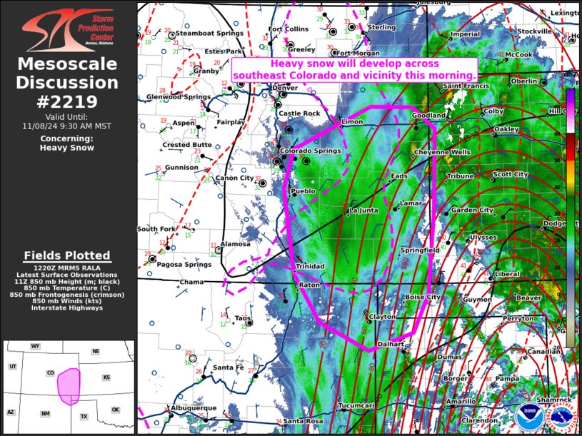
Mesoscale Discussion 2219
NWS Storm Prediction Center Norman OK
0530 PM CST Sun Nov 23 2025

Areas affected...Portions of the Permian Basin and the Edwards
Plateau

Concerning...Severe Thunderstorm Watch 637...

Valid 232330Z - 240130Z

The severe weather threat for Severe Thunderstorm Watch 637
continues.

SUMMARY...Strong/severe thunderstorms remain probable in the coming
hours across portions of the Permian Basin/Edwards Plateau where the
convective environment remains very favorable for organized
convection.

DISCUSSION...Latest radar imagery from KMAF shows a broken line of
thunderstorms between the I-20 and I-10 corridors west of the San
Angelo, TX region. While most cells remain fairly weak, a leading
supercell has shown periodic intensification and a persistent,
albeit weak, mid-level mesocyclone. Despite the meager intensity
thus far, these cells are beginning to move into the axis of better
low-level moisture where MLCAPE is regionally maximized (between
1000-1500 J/kg). Regional VWPs continue to sample elongated
hodographs featuring 0-6 km BWD values on the order of 50-60 knots.
As such, the regionally best convective environment remains
immediately downstream of ongoing cells, which may support an uptick
in convective intensity in the coming hours. Additionally, new
updraft development is noted in IR imagery on the southwestern flank
of the broken band, hinting that an increase in thunderstorm
coverage is probable. Recent CAM solutions support this idea and
suggest thunderstorm coverage may be maximized in the coming hours.

..Moore.. 11/23/2025

...Please see www.spc.noaa.gov for graphic product...

ATTN...WFO...EWX...SJT...MAF...

LAT...LON   29870237 30050267 30310288 30630303 30900301 31170284
            32090178 32290156 32370112 32340062 32240020 31979993
            31499984 31119989 30850004 30200066 29930102 29750137
            29730168 29760203 29870237

MOST PROBABLE PEAK TORNADO INTENSITY...85-115 MPH
MOST PROBABLE PEAK WIND GUST...55-70 MPH
MOST PROBABLE PEAK HAIL SIZE...1.50-2.50 IN
Read morehttps://www.spc.noaa.gov/products/md/md2219.html
|
|


CMS The Best Conveyancing solicitors conveyancing quotes throughout the UK
For any webhosting enquiries please email webmaster@aus-city.com
|
|
Forums60
Topics749,676
Posts784,348
Members2,958
| |
Most Online5,867
Nov 20th, 2025
|
|
|
|
|
Copyright 1996 - 2024 by David Cottle. Designed by David Bate Jr. All Rights Reserved.
By using this forum, the user agrees not to transfer any data or technical information received under the agreement, to any other entity without the express approval of the AUS-CITY Forum Admins and/or authors of individual posts (Forum Admins and DoD/USSPACECOM for the analysis of satellite tracking data).
Two-line elements (TLE) and all other satellite data presented and distributed via this forum and e-mail lists of AUS-CITY are distributed with permission from DoD/USSTRATCOM.

Reprise Hosting

|

|


 - Click image for larger picture.")


