|
|
|
0 members (),
975
guests, and
25
robots. |
|
Key:
Admin,
Global Mod,
Mod
|
|
S |
M |
T |
W |
T |
F |
S |
|
|
|
|
|
1
|
2
|
3
|
|
4
|
5
|
6
|
7
|
8
|
9
|
10
|
|
11
|
12
|
13
|
14
|
15
|
16
|
17
|
|
18
|
19
|
20
|
21
|
22
|
23
|
24
|
|
25
|
26
|
27
|
28
|
29
|
30
|
31
|
|
There are no members with birthdays on this day. |
|
|
Joined: Feb 2001
Posts: 381,904
Launch Director
|
OP

Launch Director
Joined: Feb 2001
Posts: 381,904 |
Volcano earthquake report for Monday, 5 Jan 2026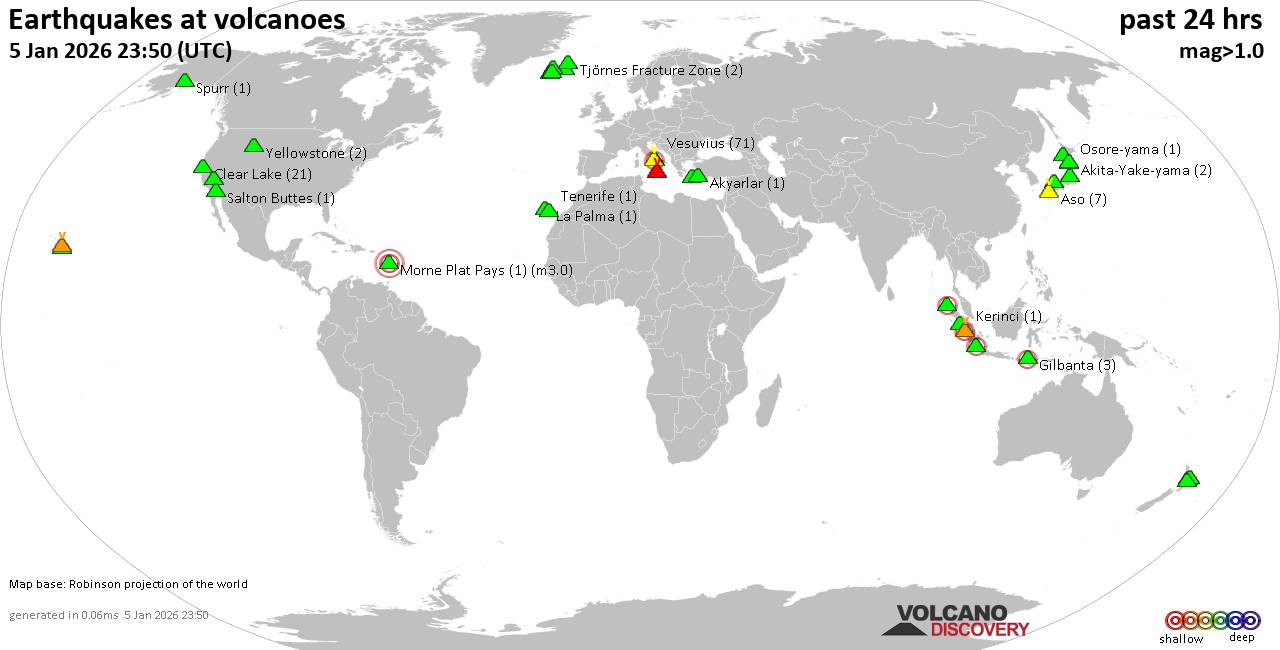 World map showing volcanoes with shallow (less than 50 km) earthquakes within 20 km radius during the past 24 hours on 5 Jan 2026 Number in brackets indicate nr of quakes. Quakes detected near: Abu (8 quakes between mag 0.4-1.0), Akuseki-jima (3 quakes between mag 1.4-2.2), Akyarlar (1 quake mag 1.6), Aso (7 quakes between mag 0.1-1.5), Bardarbunga (1 quake mag 1.2), Clear Lake (22 quakes between mag 0.5-2.2)
Denison (4 quakes between mag 1.4-3.4), El Chichón (6 quakes between mag 1.9-2.9), Erciyes Dagi (1 quake mag 1.9), Gilbanta (3 quakes between mag 2.0-2.3), Hiuchi (7 quakes between mag 0.3-1.3), Hrómundartindur (21 quakes between mag 0.1-1.0), Hulubelu (1 quake mag 2.2), Io-Torishima (1 quake mag 1.5), Iwaki (8 quakes between mag 0.7-1.5), Katla (1 quake mag 1.2), Katmai (1 quake mag 1.2), Kerinci (2 quakes between mag 2.8-3.3), Kilauea (3 quakes between mag 1.7-1.8), Kolumbo (3 quakes between mag 1.9-2.0), Kuttara (1 quake mag 1.5), La Palma (1 quake mag 1.9), Laacher See (1 quake mag 3.0), Las Cumbres (3 quakes between mag 2.0-3.6), Ljósufjöll (6 quakes between mag 0.5-1.6), Loihi (1 quake mag 2.6), Martin (2 quakes between mag 0.7-1.2), Nantai (1 quake mag 1.0), Nasu (1 quake mag 1.5), Osore-yama (1 quake mag 1.2), Paco (1 quake mag 2.2), Peuet Sague (1 quake mag 2.3), Pico de Orizaba (1 quake mag 2.4), Sibualbuali (1 quake mag 2.1), Sousaki (2 quakes between mag 1.2-1.6), Taupo (1 quake mag 1.2), Tenerife (1 quake mag 1.2), Timber Mountain (1 quake mag 2.0), Tjörnes Fracture Zone (2 quakes between mag 0.9-1.1), Torfajökull (1 quake mag 1.0), Vesuvius (51 quakes between mag 0.1-1.6), Vulcano (1 quake mag 1.4), Yake-dake (1 quake mag 1.0) (updated 05h50)
Note: Earthquakes within 20 km from and at depths less than 50 km under active volcanoes are reported. The list is not complete because many volcanoes are not monitored and/or seismic data in high resolution is not available publicly.
Volcanoes with recent earthquakes above magnitude 2 or more than 10 quakes are listed below:
Akuseki-jima volcano (Ryukyu Islands): 3 earthquakes up to magnitude 2.23 earthquakes occurred near (under) the volcano during 11 hours, the last being recorded quake 9 hours ago. Hypocenter depths ranged between 12.20 and 0.40 km. Earthquake details: 2.2 quake East China Sea, Kagoshima-ken, 35 km southwest of Suwanose-jima Island, Japan, Jan 4, 2026 06:55 pm (GMT +9) (12 km SSW) 1.8 quake East China Sea, Kagoshima-ken, 41 km southwest of Suwanose-jima Island, Japan, Jan 5, 2026 01:22 am (GMT +9) (19 km SSW) 1.4 quake East China Sea, Kagoshima-ken, 39 km southwest of Suwanose-jima Island, Japan, Jan 5, 2026 05:29 am (GMT +9) (17 km SW) All earthquakes at Akuseki-jimaClear Lake volcano (California): 22 earthquakes up to magnitude 2.2Possible earthquake swarm: 22 earthquakes occurred near (under) the volcano during 20 hours, the last being recorded quake 1 hour 23 minutes ago. Hypocenter depths ranged between 3.41 and 0.05 km. Earthquake details: (only 5 largest) 2.2 quake Sonoma County, 14 mi southwest of Clearlake, Lake County, California, United States, Jan 4, 2026 12:28 pm (GMT -8) (17 km S) 1.7 quake Sonoma County, 14 mi southwest of Clearlake, Lake County, California, United States, Jan 4, 2026 09:20 am (GMT -8) (19 km S) 1.6 quake 26 mi north of Santa Rosa, Sonoma County, California, United States, Jan 4, 2026 09:43 am (GMT -8) (19 km S) 1.3 quake 28 mi north of Santa Rosa, Sonoma County, California, United States, Jan 4, 2026 04:43 am (GMT -8) (16 km SSW) 1.3 quake Lake County, 28 mi north of Santa Rosa, Sonoma County, California, United States, Jan 4, 2026 04:17 pm (GMT -8) (15 km S) All earthquakes at Clear LakeDenison volcano (Alaska Peninsula): 4 earthquakes up to magnitude 3.44 earthquakes occurred near (under) the volcano during 2 hours, the last being recorded quake 7 hours ago. Hypocenter depths ranged between 5.93 and 0.30 km. Earthquake details: 3.4 quake Lake and Peninsula Borough, 93 mi northwest of Kodiak, Kodiak Island Borough, Alaska, United States, Jan 4, 2026 11:16 am (GMT -9) (11 km NW) 2.6 quake Lake and Peninsula Borough, 89 mi northwest of Kodiak, Kodiak Island Borough, Alaska, United States, Jan 4, 2026 01:33 pm (GMT -9) (6 km NNW) 2.2 quake Lake and Peninsula Borough, 88 mi northwest of Kodiak, Kodiak Island Borough, Alaska, United States, Jan 4, 2026 11:26 am (GMT -9) (4 km NNW) 1.4 quake Lake and Peninsula Borough, 89 mi northwest of Kodiak, Kodiak Island Borough, Alaska, United States, Jan 4, 2026 11:24 am (GMT -9) (5 km NW) All earthquakes at DenisonEl Chichón volcano (Southern Mexico): 6 earthquakes up to magnitude 2.96 earthquakes occurred near (under) the volcano during 16 hours, the last being recorded quake 8 hours ago. Hypocenter depths ranged between 3.40 and 1.20 km. Earthquake details: (only 5 largest) 2.9 quake Estado de Chiapas, 37 km southwest of Teapa, Estado de Tabasco, Mexico, Jan 4, 2026 12:13 am (GMT -6) (2 km NW) 2.4 quake Estado de Chiapas, 37 km southwest of Teapa, Estado de Tabasco, Mexico, Jan 4, 2026 08:43 am (GMT -6) (0 km NW) 2.3 quake Estado de Chiapas, 37 km southwest of Teapa, Estado de Tabasco, Mexico, Jan 4, 2026 03:53 pm (GMT -6) (0 km NE) 2.0 quake Estado de Chiapas, 37 km southwest of Teapa, Estado de Tabasco, Mexico, Jan 4, 2026 03:18 pm (GMT -6) (1 km NNW) 2.0 quake Estado de Chiapas, 37 km southwest of Teapa, Estado de Tabasco, Mexico, Jan 4, 2026 12:39 am (GMT -6) (1 km NW) All earthquakes at El ChichónGilbanta volcano (Lesser Sunda Islands): 3 earthquakes up to magnitude 2.33 earthquakes occurred near (under) the volcano during 11 minutes, the last being recorded quake 3 hours ago. Hypocenter depths ranged between 12.00 and 10.00 km. Earthquake details: 2.3 quake 61 km east of Bima, Kota Bima, West Nusa Tenggara, Indonesia, Jan 5, 2026 10:25 am (GMT +8) (4 km W) 2.3 quake Selat Sumba, 6.8 km west of Gili Banta Island, West Nusa Tenggara, Indonesia, Jan 5, 2026 10:32 am (GMT +8) (10 km WSW) 2.0 quake Selat Sumba, 6.5 km southwest of Gili Banta Island, Indonesia, Jan 5, 2026 10:36 am (GMT +8) (10 km WSW) All earthquakes at GilbantaHrómundartindur volcano (Iceland): 21 earthquakes up to magnitude 1.0Possible earthquake swarm: 21 earthquakes occurred near (under) the volcano during 17 hours, the last being recorded quake 6 hours ago. Hypocenter depths ranged between 7.10 and 0.90 km. Earthquake details: (only 5 largest) 1.0 quake 2.1 km NE of Hveragerði Jan 4, 2026 02:10 pm (Universal Time) (7 km SSE) 0.7 quake 2.4 km NE of Hveragerði Jan 4, 2026 01:41 pm (Universal Time) (7 km SSE) 0.5 quake Iceland: 2.2 km NE of Hveragerði Jan 4, 2026 02:41 pm (Reykjavik time) (7 km SSE) 0.5 quake Iceland: 2.6 km NNE of Hellisheiðarvirkjun Jan 4, 2026 11:10 pm (Reykjavik time) (9 km W) 0.4 quake 2.5 km NE of Hveragerði Jan 4, 2026 02:02 pm (Universal Time) (6 km SSE) All earthquakes at HrómundartindurHulubelu volcano (Sumatra): magnitude 2.2 earthquakeA magnitude 2.2 earthquake occurred at the volcano 5 hours ago. The quake, which might be volcanic in origin, was located at a depth of 11.00 km depth at 12 km distance SE from the volcano. Earthquake details: 2.2 quake Kabupaten Tanggamus, 69 km west of Bandar Lampung, Indonesia, Jan 5, 2026 08:05 am (GMT +7) (12 km SE) All earthquakes at HulubeluKerinci volcano (Sumatra): 2 earthquakes up to magnitude 3.32 earthquakes occurred near (under) the volcano during 2 hours, the last being recorded quake 21 hours ago. Hypocenter depths ranged between 8.00 and 5.00 km. Earthquake details: 3.3 quake Kabupaten Kerinci, 40 km northwest of Sungai Penuh, Indonesia, Jan 4, 2026 01:01 pm (GMT +7) (5 km SW) 2.8 quake Kabupaten Kerinci, 45 km northwest of Sungai Penuh, Indonesia, Jan 4, 2026 03:22 pm (GMT +7) (10 km W) All earthquakes at KerinciLaacher See volcano (Germany): magnitude 3.0 earthquakeA magnitude 3.0 earthquake occurred at the volcano 8 hours ago. The quake, which might be volcanic in origin, was located at a depth of 10.00 km depth at 16 km distance ENE from the volcano. Earthquake details: Reported seismic-like event (likely no quake): 13 km northwest of Koblenz, Kreisfreie Stadt Pirmasens, Rheinland-Pfalz, Germany, Jan 4, 2026 10:46 pm (GMT +1) (16 km ENE) All earthquakes at Laacher SeeLas Cumbres volcano (Western & Central Mexico): 3 earthquakes up to magnitude 3.63 earthquakes occurred near (under) the volcano during 13 hours, the last being recorded quake 10 hours ago. Hypocenter depths ranged between 11.00 and 4.60 km. Earthquake details: 3.6 quake 26 km northeast of Ciudad Serdan, Estado de Puebla, Mexico, Jan 4, 2026 01:29 am (Mexico City time) (3 km NW) 2.2 quake 32 km north of Orizaba, Estado de Veracruz-Llave, Mexico, Jan 4, 2026 02:07 pm (GMT -6) (7 km ESE) 2.0 quake 31 km northwest of Orizaba, Estado de Veracruz-Llave, Mexico, Jan 4, 2026 02:09 pm (GMT -6) (7 km SSE) All earthquakes at Las CumbresLoihi volcano (Hawai'i (Big Island)): magnitude 2.6 earthquakeA magnitude 2.6 earthquake occurred at the volcano 19 hours ago. The quake, which might be volcanic in origin, was located at a depth of 34.09 km depth at 17 km distance NW from the volcano. Earthquake details: 2.6 quake North Pacific Ocean, 40 mi southeast of of Hawai‘i Island, Hawaii County, Hawaii, United States, Jan 4, 2026 01:06 am (GMT -10) (17 km NW) All earthquakes at LoihiPaco volcano (Mindanao): magnitude 2.2 earthquakeA magnitude 2.2 earthquake occurred at the volcano 22 hours ago. The quake, which might be volcanic in origin, was located at a depth of 38.00 km depth at 8 km distance E from the volcano. Earthquake details: 2.2 quake 23 km southeast of Surigao, Province of Surigao del Norte, Caraga, Philippines, Jan 4, 2026 04:08 pm (GMT +8) (8 km E) All earthquakes at PacoPeuet Sague volcano (Sumatra): magnitude 2.3 earthquakeA magnitude 2.3 earthquake occurred at the volcano 4 hours ago. The quake, which might be volcanic in origin, was located at a depth of 4.00 km depth at 2 km distance SE from the volcano. Earthquake details: 2.3 quake Kabupaten Pidie, 36 km south of Reuleuet, Indonesia, Jan 5, 2026 08:51 am (GMT +7) (2 km SE) All earthquakes at Peuet SaguePico de Orizaba volcano (Western & Central Mexico): magnitude 2.4 earthquakeA magnitude 2.4 earthquake occurred at the volcano 8 hours ago. The quake, which might be volcanic in origin, was located at a depth of 10.20 km depth at 2 km distance WNW from the volcano. Earthquake details: 2.4 quake 17 km east of Ciudad Serdan, Estado de Puebla, Mexico, Jan 4, 2026 04:19 pm (GMT -6) (2 km WNW) All earthquakes at Pico de OrizabaSibualbuali volcano (Sumatra): magnitude 2.1 earthquakeA magnitude 2.1 earthquake occurred at the volcano 13 hours ago. The quake, which might be volcanic in origin, was located at a depth of 5.00 km depth at 3 km distance S from the volcano. Earthquake details: 2.1 quake 17 km north of Padangsidempuan, Kota Padangsidimpuan, North Sumatra, Indonesia, Jan 5, 2026 12:00 am (GMT +7) (3 km S) All earthquakes at SibualbualiVesuvius volcano (Italy): 51 earthquakes up to magnitude 1.6Possible earthquake swarm: 51 earthquakes occurred near (under) the volcano during 12 hours, the last being recorded quake 2 hours ago. Hypocenter depths ranged between 2.05 and 0.03 km. Earthquake details: (only 5 largest) 1.6 quake 6.4 km northeast of Torre del Greco, Napoli, Campania, Italy, Jan 5, 2026 02:48 am (GMT +1) (0 km NNE) 1.5 quake 6.3 km northeast of Torre del Greco, Napoli, Campania, Italy, Jan 5, 2026 02:11 am (GMT +1) (0 km NE) 1.3 quake 6.3 km northeast of Torre del Greco, Napoli, Campania, Italy, Jan 5, 2026 12:21 am (GMT +1) (0 km NNE) 1.0 quake 6.2 km northeast of Torre del Greco, Napoli, Campania, Italy, Jan 5, 2026 12:21 am (GMT +1) (0 km N) 0.9 quake 6.1 km northeast of Torre del Greco, Napoli, Campania, Italy, Jan 5, 2026 03:10 am (GMT +1) (0 km E) All earthquakes at Vesuviushttps://www.volcanodiscovery.com/earthquakes-volcanoes/news/291098/Volcano-earthquake-report-for-Monday-5-Jan-2026.html
|
|


CMS The Best Conveyancing solicitors conveyancing quotes throughout the UK
For any webhosting enquiries please email webmaster@aus-city.com
|
|
Forums60
Topics754,568
Posts789,262
Members2,958
| |
Most Online12,408
Dec 19th, 2025
|
|
|
|
|
Copyright 1996 - 2024 by David Cottle. Designed by David Bate Jr. All Rights Reserved.
By using this forum, the user agrees not to transfer any data or technical information received under the agreement, to any other entity without the express approval of the AUS-CITY Forum Admins and/or authors of individual posts (Forum Admins and DoD/USSPACECOM for the analysis of satellite tracking data).
Two-line elements (TLE) and all other satellite data presented and distributed via this forum and e-mail lists of AUS-CITY are distributed with permission from DoD/USSTRATCOM.

Reprise Hosting

|

|


 - Click image for larger picture.")


