|
|
|
0 members (),
5,182
guests, and
23
robots. |
|
Key:
Admin,
Global Mod,
Mod
|
|
S |
M |
T |
W |
T |
F |
S |
|
1
|
2
|
3
|
4
|
5
|
6
|
7
|
|
8
|
9
|
10
|
11
|
12
|
13
|
14
|
|
15
|
16
|
17
|
18
|
19
|
20
|
21
|
|
22
|
23
|
24
|
25
|
26
|
27
|
28
|
|
There are no members with birthdays on this day. |
|
|
Joined: Feb 2001
Posts: 381,904
Launch Director
|
OP

Launch Director
Joined: Feb 2001
Posts: 381,904 |
Small magnitude 3.1 earthquake 36 miles northwest of Bairnsdale, Victoria, Australia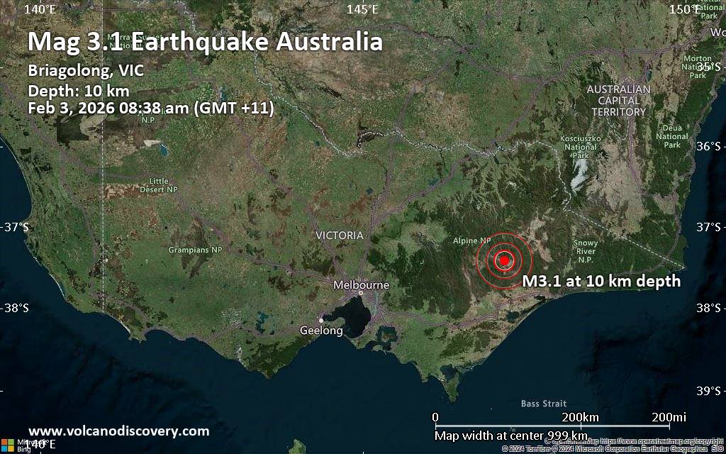 Just 13 minutes ago, a 3.1-magnitude earthquake struck near Bairnsdale, East Gippsland, Victoria, Australia. The tremor was recorded in the morning on Tuesday, February 3rd, 2026, at 8:38 am local time, at a shallow depth of 6.2 miles below the surface.
The event was filed by Geoscience Australia (GeoAu), the first seismological agency to report it.
A second report was later issued by the citizen-seismograph network of RaspberryShake, which listed it as a magnitude 3.1 earthquake as well. A third agency, the European-Mediterranean Seismological Centre (EMSC), reported the same quake at magnitude 3.1.
Towns or cities near the epicenter where the quake might have been felt as very weak shaking include Dargo (pop. 90) located 6 miles from the epicenter. In Briagolong (pop. 1,100, 30 miles away), Wy Yung (pop. 1,600, 34 miles away), Bairnsdale (pop. 15,400, 36 miles away), Stratford (pop. 2,500, 38 miles away), Falls Creek (pop. 3,300, 39 miles away), and Maffra (pop. 5,100, 40 miles away), the quake was probably not felt.
Earthquake data: Date & time: Feb 3, 2026 08:38 am (GMT +11) local time (2 Feb 2026 21:38 GMT)Magnitude: 3.1 Depth: 10.00 km Epicenter latitude / longitude: 37.42°S / 147.19°E  ( Wellington, Victoria, Australia) Primary data source: GeoAuhttps://www.volcanodiscovery.com/earthquake/news/293703/Small-magnitude-31-earthquake-36-miles-northwest-of-Bairnsdale-Victoria-Australia.html
|
|


CMS The Best Conveyancing solicitors conveyancing quotes throughout the UK
For any webhosting enquiries please email webmaster@aus-city.com
|
|
Forums60
Topics760,052
Posts794,772
Members2,957
| |
Most Online17,963
Jan 15th, 2026
|
|
|
|
|
Copyright 1996 - 2026 by David Cottle. Designed by David Bate Jr. All Rights Reserved.
By using this forum, the user agrees not to transfer any data or technical information received under the agreement, to any other entity without the express approval of the AUS-CITY Forum Admins and/or authors of individual posts (Forum Admins and DoD/USSPACECOM for the analysis of satellite tracking data).
Two-line elements (TLE) and all other satellite data presented and distributed via this forum and e-mail lists of AUS-CITY are distributed with permission from DoD/USSTRATCOM.

Reprise Hosting

|

|


 - Click image for larger picture.")


