|
0 members (),
1,076
guests, and
21
robots. |
|
Key:
Admin,
Global Mod,
Mod
|
|
S |
M |
T |
W |
T |
F |
S |
|
|
|
|
|
|
|
1
|
|
2
|
3
|
4
|
5
|
6
|
7
|
8
|
|
9
|
10
|
11
|
12
|
13
|
14
|
15
|
|
16
|
17
|
18
|
19
|
20
|
21
|
22
|
|
23
|
24
|
25
|
26
|
27
|
28
|
29
|
|
30
|
31
|
|
|
|
|
|
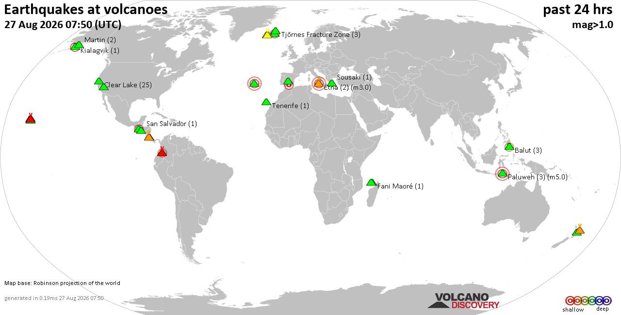
Volcano earthquake report for Thursday, 27 Aug 2026
• Strong mag. 5.2 earthquake - 334 km south of Ogasawara, Tokyo, Japan, on Th...
• Seismic-like event, possible earthquake, reported minutes ago near Granada,...
• World Earthquake Report for Thursday, 27 August 2026
• Possible earthquake reported near Acapulco de Juárez, Guerrero, Mexico, a ...
• Moderate mag. 4.3 earthquake - 16 km southeast of Acapulco de Juárez, Esta...
|
|
|
Joined: Feb 2001
Posts: 678,977
Launch Director
|
|
Launch Director
Joined: Feb 2001
Posts: 678,977 |
SPC Aug 27, 2026 0600 UTC Day 2 Convective OutlookSPC 0600Z Day 2 Outlook 
Day 2 Convective Outlook
NWS Storm Prediction Center Norman OK
1259 AM CDT Thu Aug 27 2026

Valid 281200Z - 291200Z

...THERE IS A MARGINAL RISK OF SEVERE THUNDERSTORMS FOR NORTH
GEORGIA INTO THE CAROLINAS AND VIRGINIA AND PORTIONS OF THE
NORTHERN/CENTRAL PLAINS....

...SUMMARY...
Isolated strong to severe storms are possible across northern
Georgia into the Carolinas and Virginia and the northern/central
Plains.

...North Georgia to the Carolinas...
Moderate to potentially strong instability is forecast to develop
south of a stalled cold front from the southern Appalachians to the
Mid-Atlantic where upper 60s to low 70s dewpoints will be present.
Lapse rates will be quite weak (~6 C/km), but most guidance shows
temperatures warming into the low to mid 80s which should provide
pockets of moderate to strong instability. Effective shear is
forecast to be weak (15 to 20 knots), but only slight modifications
in the effective layer calculation result in significantly greater
effective shear (30 to 35 knots) given moderate to strong flow above
7km. Therefore, any storms that can take advantage of this stronger
flow aloft may be longer-lived and capable of some damaging wind
gusts.

...Central/Northern Nebraska into central and eastern South Dakota
and Vicinity...
A mid-level ridge will slowly deamplify through the day on Friday
across the northern Plains. As this occurs, lee troughing will
strengthen through the day with a lee cyclone forecast to develop
across western South Dakota by early Saturday morning. Strengthening
southeasterly flow ahead of the lee trough will advect low to
potentially mid 60s dewpoints into South Dakota. This will result in
moderate to potentially strong instability in the region. However,
most forecast soundings show the environment remaining capped for
much of the day which casts some doubt on diurnal storm coverage.
Some 00Z CAM guidance shows storms prior to 00Z across western
portions of the Marginal Risk area, but without strong forcing, it
is unclear if these storms will develop. Given the capped airmass,
the primary storm focus will likely be across northeast Nebraska and
eastern South Dakota, at the nose of the low-level jet where
warm-air advection will strengthen in the evening. Forecast
soundings show moderate to strong instability and strong shear
within this zone after 00Z. Large hail may be the primary threat in
the evening with the wind threat more dependent on potential upscale
growth.

..Bentley.. 08/27/2026
Read morehttps://www.spc.noaa.gov/products/outlook/day2otlk_0600.html
|
|



CMS The Best Conveyancing solicitors conveyancing quotes throughout the UK
For any webhosting enquiries please email webmaster@aus-city.com
|
|
Forums60
Topics813,288
Posts848,081
Members2,960
| |
Most Online102,106
Jul 10th, 2026
|
|
|





































