|
0 members (),
774
guests, and
22
robots. |
|
Key:
Admin,
Global Mod,
Mod
|
|
S |
M |
T |
W |
T |
F |
S |
|
|
|
|
|
|
|
1
|
|
2
|
3
|
4
|
5
|
6
|
7
|
8
|
|
9
|
10
|
11
|
12
|
13
|
14
|
15
|
|
16
|
17
|
18
|
19
|
20
|
21
|
22
|
|
23
|
24
|
25
|
26
|
27
|
28
|
29
|
|
30
|
31
|
|
|
|
|
|
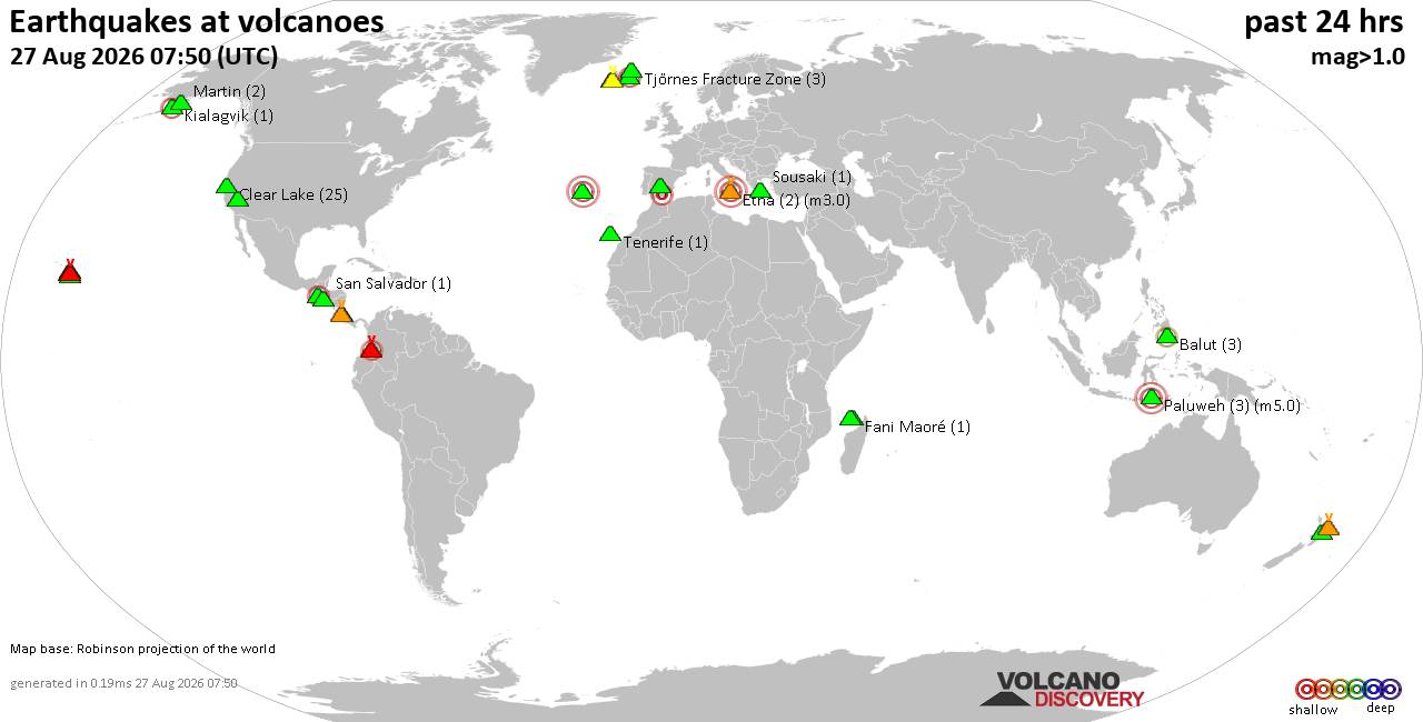
Volcano earthquake report for Thursday, 27 Aug 2026
• Strong mag. 5.2 earthquake - 334 km south of Ogasawara, Tokyo, Japan, on Th...
• Seismic-like event, possible earthquake, reported minutes ago near Granada,...
• World Earthquake Report for Thursday, 27 August 2026
• Possible earthquake reported near Acapulco de Juárez, Guerrero, Mexico, a ...
• Moderate mag. 4.3 earthquake - 16 km southeast of Acapulco de Juárez, Esta...
|
|
|
Joined: Feb 2001
Posts: 678,977
Launch Director
|
|
Launch Director
Joined: Feb 2001
Posts: 678,977 |
SPC Day 1 Fire Weather OutlookSPC Day 1 Fire Weather Outlook 
Day 1 Fire Weather Outlook
NWS Storm Prediction Center Norman OK
0103 AM CDT Thu Aug 27 2026

Valid 271200Z - 281200Z

...CRITICAL FIRE WEATHER AREA FOR FAR NORTHEASTERN
CALIFORNIA...NORTHWESTERN NEVADA...SOUTHEASTERN OREGON...

...Synopsis...
An upper-level trough will continue to promote fire weather concerns
across portions of the northwestern CONUS, northern Great Basin and
northern Rockies today. Enhanced southwest winds and dry conditions
will bring elevated fire weather conditions across the Columbia
Basin with a more pronounced critical fire weather threat from far
northeastern CA into southeastern OR. Farther east, sufficient
mid-level moisture, upper diffluence ahead of the aforementioned
trough and daytime instability, will aid in development in
high-based thunderstorms across portions of the northern Rockies and
adjacent MT high plains. Breezy offshore winds across Southern
California will present an elevated fire weather threat this evening
and tonight after well-above normal temperatures this afternoon.

...Pacific Northwest into Oregon High Desert and northeastern
California...
Dry, downslope flow into the Columbia Basin is expected today as
upper trough pushes farther into the Pacific Northwest. As the
onshore pressure gradient tightens, west to southwest winds of
around 15 mph (locally 20 mph in areas just east and adjacent to the
Cascades) will develop and couple with RH as low as 15% by
mid-afternoon. These atmospheric conditions along with receptive
fuels will promote an elevated fire weather threat across the
Columbia Basin. Farther south, a 50-60 knot mid-level jet will
stretch from northeastern CA into central ID. Diminishing cloud
cover from southwest to northeast will enhance boundary layer mixing
most across far northeastern CA, far northwestern NV and
southeastern OR where sustained surface winds of 15-25 mph are
expected this afternoon. Within this corridor of stronger winds, RH
should fall to below 10% at times by peak heating. Fuels remain
quite dry with forecast ERCs near the 95th percentile. This
meteorological setup along with a receptive fuelscape (as evidenced
by recent fire activity) supports critical fire weather highlights
from far northeastern CA into southeastern OR.

...Northern Rockies...
A supportive thunderstorm environment will exist over portions of
the northern Rockies as the Pacific Northwest trough translates
eastward. Forcing for ascent ahead of the trough, aligning with
mid/upper level moisture and daytime instability, will bring mainly
high-based thunderstorms to portions of central ID into much of
western MT. Increasing thunderstorm motions to the east-northeast
will be bolstered by strengthening vertical wind shear as the upper
trough pushes east, further limiting rainfall accumulation in lower
elevations. Isolated dry thunderstorm highlights remain over this
region with only minor changes.

...Southern California...
A northerly wind component will increase again this evening and
tonight across portions of southern CA as the offshore pressure
gradient tightens. Hot and dry conditions during the day with near
record high temperatures in the 90s and 100s away from the coast are
supporting increasingly dry fuels across the region. Wind speeds of
10-20 mph with higher gusts are possible in wind prone areas and
terrain gap features across LA/Ventura/Santa Barbara counties. These
winds coupled with RH around 20% will present an elevated fire
weather threat.

..Williams.. 08/27/2026

...Please see www.spc.noaa.gov/fire for graphic product...
Read morehttps://www.spc.noaa.gov/products/fire_wx/fwdy1.html
|
|



CMS The Best Conveyancing solicitors conveyancing quotes throughout the UK
For any webhosting enquiries please email webmaster@aus-city.com
|
|
Forums60
Topics813,331
Posts848,124
Members2,960
| |
Most Online102,106
Jul 10th, 2026
|
|
|





































