|
|
|
0 members (),
1,877
guests, and
21
robots. |
|
Key:
Admin,
Global Mod,
Mod
|
|
S |
M |
T |
W |
T |
F |
S |
|
|
|
|
1
|
2
|
3
|
4
|
|
5
|
6
|
7
|
8
|
9
|
10
|
11
|
|
12
|
13
|
14
|
15
|
16
|
17
|
18
|
|
19
|
20
|
21
|
22
|
23
|
24
|
25
|
|
26
|
27
|
28
|
29
|
30
|
31
|
|
|
There are no members with birthdays on this day. |
|
|
|
|
|
|
|
|
|
|
|
|
|
|
|
|
|
|
|
|
|
|
by Webmaster - Sun 26 Jul 2026 08:45:PM
|

World Earthquake Report for Sunday, 26 July 2026
• Moderate mag. 4.5 earthquake - Estado de Veracruz-Llave, Mexico, on 2026-07...
• Volcano earthquake report for Sunday, 26 Jul 2026
• Moderate mag. 4.0 earthquake - Kabupaten Kepulauan Talaud, 148 km northeast...
• Light mag. 3.9 earthquake - North Pacific Ocean, 65 km south of Puerto San ...
• Strong mag. 5.4 earthquake - Northern Mid-Atlantic Ridge on Sunday, Jul 26,...
|
 SPC Severe Thunderstorm Watch 518 Status Reports
Webmaster
4 hours ago
SPC Severe Thunderstorm Watch 518 Status Reports
Webmaster
4 hours ago
SPC Severe Thunderstorm Watch 518 Status ReportsWW 0518 Status Updates 
STATUS REPORT ON WW 518

SEVERE WEATHER THREAT CONTINUES RIGHT OF A LINE FROM 25 S BJI TO
70 NE RRT.

..WENDT..07/27/26

ATTN...WFO...MQT...DLH...FGF...GRB...


STATUS REPORT FOR WS 518

SEVERE WEATHER THREAT CONTINUES FOR THE FOLLOWING AREAS

MIC053-131-270940-

MI
.    MICHIGAN COUNTIES INCLUDED ARE

GOGEBIC              ONTONAGON


MNC031-061-071-075-137-270940-

MN
.    MINNESOTA COUNTIES INCLUDED ARE

COOK                 ITASCA              KOOCHICHING
LAKE                 ST. LOUIS


WIC003-007-031-037-041-051-067-069-075-078-083-085-099-113-115-
125-129-270940-

WI
.    WISCONSIN COUNTIES INCLUDED ARE

ASHLAND              BAYFIELD            DOUGLAS
FLORENCE             FOREST              IRON
Read morehttps://www.spc.noaa.gov/products/watch/ws0518.html
0
7
Read More
|
SPC Severe Thunderstorm Watch 518
Webmaster
4 hours ago
SPC Severe Thunderstorm Watch 518WW 518 SEVERE TSTM MI MN WI LS 270630Z - 271400Z
URGENT - IMMEDIATE BROADCAST REQUESTED
Severe Thunderstorm Watch Number 518
NWS Storm Prediction Center Norman OK
130 AM CDT Mon Jul 27 2026

The NWS Storm Prediction Center has issued a

* Severe Thunderstorm Watch for portions of
  Upper Michigan
  Northern Minnesota
  Northern Wisconsin
  Lake Superior

* Effective this Monday morning from 130 AM until 900 AM CDT.

* Primary threats include...
  Scattered large hail and isolated very large hail events to 2
    inches in diameter possible
  Scattered damaging wind gusts to 70 mph possible
  A tornado or two possible

SUMMARY...Scattered thunderstorms will continue to increase in
coverage and intensity overnight as they moved southeastward
regionally. Large hail will the most common concern overnight,
although damaging wind potential could increase toward dawn and
beyond if storms begin to cluster and organize.

The severe thunderstorm watch area is approximately along and 80
statute miles north and south of a line from 80 miles west of
International Falls MN to 15 miles south southeast of Iron Mountain
MI. For a complete depiction of the watch see the associated watch
outline update (WOUS64 KWNS WOU8).

PRECAUTIONARY/PREPAREDNESS ACTIONS...

REMEMBER...A Severe Thunderstorm Watch means conditions are
favorable for severe thunderstorms in and close to the watch area.
Persons in these areas should be on the lookout for threatening
weather conditions and listen for later statements and possible
warnings. Severe thunderstorms can and occasionally do produce
tornadoes.

&&

AVIATION...A few severe thunderstorms with hail surface and aloft to
2 inches. Extreme turbulence and surface wind gusts to 60 knots. A
few cumulonimbi with maximum tops to 600. Mean storm motion vector
30025.

...Guyer
Read morehttps://www.spc.noaa.gov/products/watch/ww0518.html
0
7
Read More
|
SPC Jul 27, 2026 Day 4-8 Severe Weather Outlook
Webmaster
4 hours ago
SPC Jul 27, 2026 Day 4-8 Severe Weather OutlookDay 4-8 Outlook 
Day 4-8 Convective Outlook
NWS Storm Prediction Center Norman OK
0326 AM CDT Mon Jul 27 2026

Valid 301200Z - 041200Z

...DISCUSSION...
...Day 4/Thursday...

A short-wave trough is forecast to move through the northern Plains
and upper MS Valley, within the northeast periphery of an upper high
centered over the southern Rockies. At the surface, a weak cold
front is expected to follow the track of the upper-air system with
moderate to strong instability expected by afternoon ahead of the
boundary. Various deterministic and ensemble guidance indicates
thunderstorms developing over the northern Plains into the upper MS
Valley with subsequent movement into the mid MO Valley and perhaps
upper Midwest Thursday night. Forecast vertical shear is on the
margins of that which supports organized storm modes and an
associated greater severe weather threat. Nonetheless, isolated
severe weather appears likely, requiring at least low probabilities
in the Day 3 time frame.


...Day 5/Friday...

The Day 4 short-wave trough is expected to continue southeast
through the Midwest with an associated surface low developing into
the mid MS Valley. A trailing cool front will extend through the
Ozark Plateau into the Southern Plains. Persistent low-level ridging
from the lower Great Lakes into the TN Valley will limit the
eastward extent of more robust air mass destabilization ahead of the
surface low and along the track of the short-wave trough. It does
appear that a corridor of stronger instability and modest vertical
shear will develop from the mid MS Valley into the Ozark Plateau,
where a few severe storms appear possible.


...Day 6-8/Saturday through Monday...

The 00Z ensemble means remain in good agreement in depicting a
stronger short-wave trough and attending belt of mid-level flow
progressing along the international border from the Pacific
northwest to the northern Plains. Some severe weather threat could
materialize along an associated cold front over the northern Plains
on Sunday and the northern Plains into the upper MS Valley on
Monday.
Read morehttps://www.spc.noaa.gov/products/exper/day4-8/
0
7
Read More
|
SPC Jul 27, 2026 0730 UTC Day 3 Severe Thunderstorm Outlook
Webmaster
5 hours ago
SPC Jul 27, 2026 0730 UTC Day 3 Severe Thunderstorm OutlookSPC 0730Z Day 3 Outlook 
Day 3 Convective Outlook
NWS Storm Prediction Center Norman OK
0200 AM CDT Mon Jul 27 2026

Valid 291200Z - 301200Z

...THERE IS A MARGINAL RISK OF SEVERE THUNDERSTORMS IN THE SOUTHEAST
AND NORTHERN AND CENTRAL HIGH PLAINS...

...SUMMARY...
Isolated severe storms capable of mainly damaging winds appear
possible in the Southeast and northern and central High Plains
Wednesday afternoon into evening.

...Synopsis...

A short-wave trough will move through the Canadian Prairie
Provinces, effectively flattening the northern extension of the
upper ridge in those areas. There is some model signal for a
lower-latitude disturbance to progress from the northern Rockies
into the northern High Plains. Elsewhere, an upper low over the
Mid-Atlantic will evolve into an open wave with the broader-scale
trough slowly shifting east. At the surface, a cool front will
settle south through the Southeast, while a lee trough deepens over
the northern High Plains.


...Southeast...

A hot and very moist air mass is expected ahead of the front, with
moderate to strong instability developing by afternoon. The models
suggest the stronger mid-level winds and resultant vertical shear
will be displaced to the north of the frontal zone, which should
limit the organizational potential of the storms developing along
the boundary. Nonetheless, the degree of instability and high
precipitable water content will favor locally intense wet
microbursts capable of damaging winds, especially with any storm
clusters that may evolve.


...Northern and central High Plains...

A hot and deeply mixed boundary layer is forecast east of the lee
trough Wednesday afternoon with steep low/mid-level lapse rates
contributing to moderate instability. Diurnally enhanced storm
coverage along the boundary remains uncertain due to the absence of
any appreciable forcing mechanisms, except perhaps the weak
disturbance mentioned above. Nonetheless, the presence of the steep
lapse rates and latent cooling potential in the sub-cloud layer
suggests a threat for severe wind gusts and perhaps large hail with
any storms that develop.

..Mead.. 07/27/2026
Read morehttps://www.spc.noaa.gov/products/outlook/day3otlk_0730.html
0
7
Read More
|
SPC Jul 27, 2026 0600 UTC Day 2 Convective Outlook
Webmaster
6 hours ago
SPC Jul 27, 2026 0600 UTC Day 2 Convective OutlookSPC 0600Z Day 2 Outlook 
Day 2 Convective Outlook
NWS Storm Prediction Center Norman OK
1220 AM CDT Mon Jul 27 2026

Valid 281200Z - 291200Z

...THERE IS A SLIGHT RISK OF SEVERE THUNDERSTORMS FROM THE SOUTHERN
MID-ATLANTIC INTO THE CAROLINAS AND CENTRAL AND SOUTHERN
APPALACHIANS...

...SUMMARY...
Severe thunderstorms capable of damaging winds and isolated hail are
possible from the southern Mid-Atlantic into the Carolinas and
central and southern Appalachians Tuesday into Tuesday evening.
Isolated severe wind gusts and large hail may occur in the central
High Plains.

...Synopsis...

Considerable trough amplification is forecast over the eastern CONUS
this period, aided by the propagation of the mid/upper-level jet
streaks from the Great Lakes and OH Valley through VA and NC. A
series of vorticity maxima is forecast on the cyclonic side of the
jet streaks, which will enhance forcing for ascent over the central
Appalachians into the Mid-Atlantic. At the surface, the primary low
pressure is expected to deepen over the Delmarva with a secondary
cyclone over western NY. A lee trough will extend from the Delmarva
low south-southwest along the Piedmont, ahead of a cold front moving
through the TN Valley and central and southern Appalachians.


...Mid-Atlantic into the Southern Appalachians...

Showers and thunderstorms (some potentially severe with damaging
winds) are expected to be ongoing Tuesday morning from the lower
Great Lakes into the central Appalachians. The longevity and areal
extent of the early-day storms will be a determinant in where more
robust air mass destabilization will take place during the
afternoon. The 00Z HREF calibrated thunder probabilities suggest the
most likely areas for persistent morning storms will be from NY and
PA into the Delmarva and WV. To the south of those locations,
stronger daytime heating appears more probable, which, combined with
boundary-layer dewpoints in the upper 60s to mid 70s, will yield
moderate to potentially strong afternoon instability with MLCAPE of
1500-2500+ J/kg.

Thunderstorms are expected to increase in coverage and intensity
during the afternoon along and ahead of the cold front and lee
trough as background forcing for ascent strengthens in the left exit
region of the approaching upper-level jet streak. The presence of
the mid/upper-level wind maxima will yield long hodographs with
sufficient vertical shear for supercells and bowing structures. The
strengthening shear combined with cooling mid-level temperatures
will be supportive of large-hail production with any supercells that
form. Otherwise, damaging winds will be the primary hazard,
especially with any storm clusters or bowing line segments. Some
tornado threat could also materialize Tuesday afternoon into evening
near and south of the Delmarva surface low where slightly stronger
low-level shear is forecast.


...Central High Plains...

Strong heating of a moist, upslope-flow air mass is expected to
yield a moderately unstable environment by afternoon with MLCAPE of
1500-2500 J/kg. Isolated to widely scattered thunderstorm
development appears possible by mid- to late afternoon along the
high terrain within a kinematic environment featuring 30-35 kt
westerly deep-layer shear. Transient supercell structures appear
possible, which suggest some marginally severe hail potential,
despite the warm mid-level temperatures. There is some model signal
for storm clustering over the adjacent High Plains by evening, at
which point the threat for isolated severe wind gusts would
increase.

..Mead.. 07/27/2026
Read morehttps://www.spc.noaa.gov/products/outlook/day2otlk_0600.html
0
7
Read More
|
SPC Jul 27, 2026 0600 UTC Day 1 Convective Outlook
Webmaster
6 hours ago
SPC Jul 27, 2026 0600 UTC Day 1 Convective OutlookSPC 1200Z Day 1 Outlook 
Day 1 Convective Outlook
NWS Storm Prediction Center Norman OK
1252 AM CDT Mon Jul 27 2026

Valid 271200Z - 281200Z

...THERE IS AN ENHANCED RISK OF SEVERE THUNDERSTORMS FROM PORTIONS
OF THE UPPER MIDWEST/UPPER GREAT LAKES INTO THE OHIO VALLEY...

...THERE IS A SLIGHT RISK OF SEVERE THUNDERSTORMS ACROSS PORTIONS OF
SOUTHWEST SOUTH DAKOTA...WESTERN NEBRASKA...NORTHEAST COLORADO...AND
FAR NORTHWEST KANSAS...

...SUMMARY...
Severe storms capable of strong to severe wind gusts and large hail
are possible across the Great Lakes into the Ohio Valley Monday into
Monday night. More sporadic occurrences of damaging wind appear
possible in the Mid-Atlantic, Tennessee Valley, central High Plains,
and southeast Arizona.

...Upper Midwest/Great Lakes into the OH/TN Valleys...
A very moist airmass is in place from the Upper Midwest into the OH
and TN Valley. This airmass is exists south of a diffuse cold front
that extends from a surface low over far southeast Manitoba
southeastward to far eastern Upper MI. One thunderstorm is currently
ongoing near this boundary over eastern Upper MI. Most of the
thunderstorms are ongoing just northeast another surface boundary
demarcating the very moist (i.e. 70+ dewpoints) to it southwest. How
this warm-air advection activity evolves early this morning will
have a large impact on the severe potential farther downstream from
the Mid MS Valley into the OH and TN Valleys through the late
morning into the afternoon and evening.

Much of the guidance is beginning to suggest the warm-air advection
activity clusters early this morning over the MN Arrowhead vicinity
before then tracking southeastward within the moisture/buoyancy
gradient and organizing/intensifying significantly. Synoptically,
the overall setup matches many characteristics of scenarios with
strong, forward-propagating MCSs, including a surface boundary
parallel to the deep-layer shear, at least modest mid-level warm
advection, and very strong to extreme buoyancy. Given the trend
within the guidance and favorable synoptics, confidence in the
development of a strong forward-propagating MCS is high enough to
adjust the 30% wind probabilities westward while also introducing a
CIG1 area. There is a chance that both higher wind probabilities and
a CIG2 may be needed, but predictability regarding convective
evolution is too low at this time.

...Central High Plains into western/central NE and SD...
Moist, post-frontal surface flow is expected across much of NE and
SD, shifting from northerly early in the day to more easterly by the
afternoon. Dewpoints will initially be in the mid to upper 70s,
although strong boundary-layer mixing will likely result in
dewpoints ranging from the upper 50s/low 60s across the NE Panhandle
to the low 70s across eastern NE. This reservoir of low-level
moisture coupled with strong heating and steep mid-level lapse rates
will result in a corridor of moderate to extreme buoyancy from
eastern WY/northeast CO/southwest SD eastward across south-central
SD and much of NE.

Most of the guidance indicates a subtle, convectively augmented
vorticity maximum will progress eastward through the northern
periphery of the Four Corner upper ridge. This should contribute to
thunderstorm development across the high terrain, which would then
progress downstream into a more moist and unstable airmass. One or
more clusters could evolve, but the overall predictability of the
convective evolution is low. That being said, environmental
conditions support the potential for strong to severe gusts,
including the potential for some over 75 mph. Eastern extent of the
wind threat will likely be limited by building convective inhibition
associated with nocturnal cool, unless a  more coherent and
organized MCS were to evolve. If that occurs, the wind threat could
extend farther east into more of eastern NE and north-central KS,
and 5% wind probabilities were expanded eastward/southeastward to
account for this potential.

Depending on the strength of the MCS, the wind threat could extend
eastward into more of OH and PA, and also farther southward into
more of TN, during the late afternoon/evening.

...Mid-Atlantic States...
Some wind threat could exist during the afternoon/evening across the
Mid-Atlantic, where marginal buoyancy and deep-layer shear could
support a few stronger updrafts.

...Southeast Arizona...
Isolated severe gusts are possible over southeast AZ as mid-level
moisture and daytime heating leads to scattered storms over
the higher terrain, particularly far southeast AZ. Cells are
expected to move westward into warmer temperatures and deeper
boundary-layer mixing, with PWAT over 1.25" and steep low-level
lapse rates supporting strong outflows.

..Mosier/Squitieri.. 07/27/2026
Read morehttps://www.spc.noaa.gov/products/outlook/day1otlk_1200.html
0
7
Read More
|
World Earthquake Report for Sunday, 26 July 2026
Webmaster
Yesterday at 08:20 PM
World Earthquake Report for Sunday, 26 July 2026Worldwide earthquakes above magnitude 3 during the past 24 hours on 26 Jul 2026 Magnitude 5+: 6 earthquakes Magnitude 4+: 52 earthquakes Magnitude 3+: 169 earthquakes Magnitude 2+: 361 earthquakes No quakes of magnitude 6 or higher 10 largest earthquakes in the world (past 24 hours)Saturday, Jul 25, 2026, at 08:35 pm (GMT -12) - Sunday, Jul 26, 2026, at 03:19 pm (GMT -3) - Sunday, Jul 26, 2026, at 06:57 pm (Makassar time) - Sunday, Jul 26, 2026, at 12:32 am (GMT -1) - Saturday, Jul 25, 2026, at 09:03 am (GMT -12) - Sunday, Jul 26, 2026, at 07:17 pm (GMT +12) - Sunday, Jul 26, 2026, at 09:39 am (GMT +12) - Sunday, Jul 26, 2026, at 08:36 pm (Taipei time) - Saturday, Jul 25, 2026, at 09:13 pm (Bogota time) - Sunday, Jul 26, 2026, at 03:26 am (GMT -6) - Earthquakes reported feltSunday, Jul 26, 2026, at 03:39 pm (GMT +2) - Sunday, Jul 26, 2026, at 06:25 pm (GMT +3) - Sunday, Jul 26, 2026, at 08:36 pm (Taipei time) - Saturday, Jul 25, 2026, at 09:13 pm (Bogota time) - Sunday, Jul 26, 2026, at 06:57 pm (Makassar time) - Sunday, Jul 26, 2026, at 09:43 am (GMT +2) - Sunday, Jul 26, 2026, at 04:11 pm (GMT +2) - Sunday, Jul 26, 2026, at 05:39 pm (GMT +9) - Saturday, Jul 25, 2026, at 03:36 pm (GMT -6) - Sunday, Jul 26, 2026, at 09:40 am (GMT +10) - Saturday, Jul 25, 2026, at 05:46 pm (GMT -4) - Sunday, Jul 26, 2026, at 05:39 am (Yangon time) - Saturday, Jul 25, 2026, at 08:35 pm (GMT -12) - Sunday, Jul 26, 2026, at 04:04 am (Guatemala time) - Sunday, Jul 26, 2026, at 07:17 pm (GMT +12) - Sunday, Jul 26, 2026, at 06:42 pm (GMT +8) - Sunday, Jul 26, 2026, at 06:23 am (GMT -5) - Sunday, Jul 26, 2026, at 09:36 am (Santiago time) - Sunday, Jul 26, 2026, at 11:17 pm (Manila time) - Earthquake stats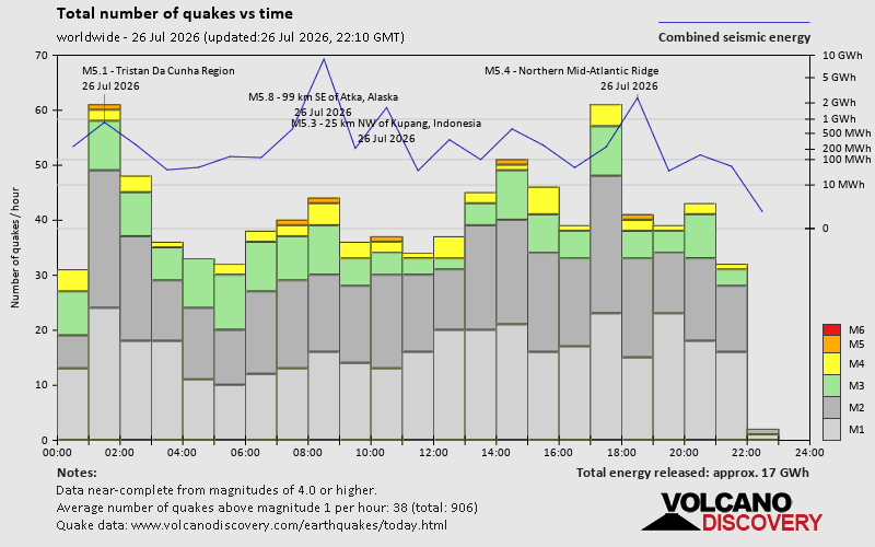 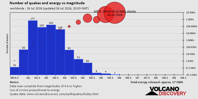 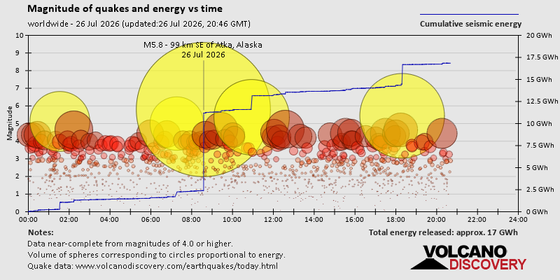 https://www.volcanodiscovery.com/earthquake/news/321044/World-Earthquake-Report-for-Sunday-26-July-2026.html https://www.volcanodiscovery.com/earthquake/news/321044/World-Earthquake-Report-for-Sunday-26-July-2026.html
0
33
Read More
|
Volcano earthquake report for Sunday, 26 Jul 2026
Webmaster
Yesterday at 07:50 PM
Volcano earthquake report for Sunday, 26 Jul 2026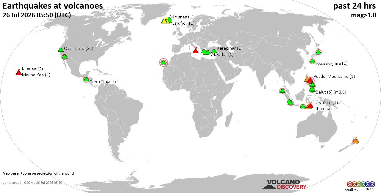 World map showing volcanoes with shallow (less than 50 km) earthquakes within 20 km radius during the past 24 hours on 26 Jul 2026 Number in brackets indicate nr of quakes. Quakes detected near: Akuseki-jima (1 quake mag 2.3), Balut (6 quakes between mag 1.4-3.0), Brennisteinsfjöll (3 quakes between mag 0.1-1.0), Cabalian (1 quake mag 2.2), Campi Flegrei (Phlegrean Fields) (15 quakes between mag 0.0-1.6), Clear Lake (23 quakes between mag 0.4-1.2)
Coso (4 quakes between mag 0.9-1.3), Don Joao de Castro Bank (1 quake mag 2.0), El Chichón (1 quake mag 2.6), Eldey (7 quakes between mag 0.6-1.9), Etna (1 quake mag 1.2), Fourpeaked (1 quake mag 1.6), Geureudong (1 quake mag 2.2), Grímsnes (1 quake mag 1.1), Hiuchi (1 quake mag 2.8), Hulubelu (3 quakes between mag 2.1-2.5), Karapinar (1 quake mag 1.5), Katla (4 quakes between mag 1.0-1.3), Kolumbo (2 quakes between mag 1.6-1.6), Krísuvík (5 quakes between mag 0.0-1.3), La Palma (2 quakes between mag 1.4-2.0), Loihi (1 quake mag 2.1), Mayon (1 quake mag 3.0), Mayotte Island (1 quake mag 1.3), Methana (1 quake mag 1.4), Naolinco (1 quake mag 3.2), Parker (1 quake mag 2.5), Patah (1 quake mag 3.0), Patoc (1 quake mag 2.2), Pinatubo (1 quake mag 1.6), Piparo (1 quake mag 3.0), Pocdol Mountains (2 quakes between mag 1.4-1.4), Rinjani (1 quake mag 2.6), Sangeang Api (1 quake mag 2.3), Santo Tomas (1 quake mag 1.8), Svartsengi (1 quake mag 1.1), Taal (1 quake mag 3.0), Taupo (1 quake mag 1.6), Tenerife (7 quakes between mag 0.8-1.3), Theistareykjarbunga (3 quakes between mag 0.6-1.0), White Island (1 quake mag 2.1) (updated 19h50)
Note: Earthquakes within 20 km from and at depths less than 50 km under active volcanoes are reported. The list is not complete because many volcanoes are not monitored and/or seismic data in high resolution is not available publicly.
Volcanoes with recent earthquakes above magnitude 2 or more than 10 quakes are listed below:
Akuseki-jima volcano (Ryukyu Islands): magnitude 2.3 earthquakeA magnitude 2.3 earthquake occurred at the volcano 19 hours ago. The quake, which might be volcanic in origin, was located at a depth of 20.00 km depth at 12 km distance SW from the volcano. Earthquake details: 2.3 quake Ryukyu Islands, Japan, Jul 26, 2026 10:04 am (GMT +9) (12 km SW) All earthquakes at Akuseki-jimaBalut volcano (Mindanao): 6 earthquakes up to magnitude 3.06 earthquakes occurred near (under) the volcano during 23 hours, the last being recorded quake 40 minutes ago. Hypocenter depths ranged between 40.00 and 10.00 km. Earthquake details: (only 5 largest) 3.0 quake Mindanao, Philippines, Jul 26, 2026 04:08 am (GMT +8) (5 km ENE) 2.4 quake Philippines: 006 km N 79° W of Sarangani Island (Municipality of Sarangani) (Davao Occidental) Jul 27, 2026 03:10 am (GMT +8) (10 km NNE) 2.1 quake 016 km S 73° W of Balut Island (Municipality of Sarangani) (Davao Occidental) Jul 26, 2026 07:48 pm (GMT +8) (11 km WSW) 1.7 quake 012 km N 80° W of Balut Island (Municipality of Sarangani) (Davao Occidental) Jul 26, 2026 05:41 pm (GMT +8) (8 km WNW) 1.5 quake Philippines: 019 km S 71° W of Balut Island (Municipality of Sarangani) (Davao Occidental) Jul 26, 2026 02:39 pm (GMT +8) (13 km WSW) All earthquakes at BalutCabalian volcano (Central Philippines): magnitude 2.2 earthquakeA magnitude 2.2 earthquake occurred at the volcano 10 hours ago. The quake, which might be volcanic in origin, was located at a depth of 13.00 km depth at 7 km distance SSW from the volcano. Earthquake details: 2.2 quake 003 km S 24° E of San Juan (Southern Leyte) Jul 26, 2026 05:38 pm (GMT +8) (7 km SSW) All earthquakes at CabalianCampi Flegrei (Phlegrean Fields) volcano (Italy): 15 earthquakes up to magnitude 1.6Possible earthquake swarm: 15 earthquakes occurred near (under) the volcano during 5 hours, the last being recorded quake 50 minutes ago. Hypocenter depths ranged between 2.44 and 0.43 km. Earthquake details: (only 5 largest) 1.6 quake Italy: Campi Flegrei Jul 26, 2026 05:00 pm (GMT +2) (1 km SSE) 1.2 quake Campi Flegrei Jul 26, 2026 04:58 pm (GMT +2) (1 km SSE) 1.1 quake Campi Flegrei Jul 26, 2026 09:00 pm (GMT +2) (1 km SSE) 1.1 quake Campi Flegrei Jul 26, 2026 05:00 pm (GMT +2) (1 km SSE) 1.1 quake Campi Flegrei Jul 26, 2026 04:58 pm (GMT +2) (8 km SSE) All earthquakes at Campi Flegrei (Phlegrean Fields)Clear Lake volcano (California): 23 earthquakes up to magnitude 1.2Possible earthquake swarm: 23 earthquakes occurred near (under) the volcano during 23 hours, the last being recorded quake 20 minutes ago. Hypocenter depths ranged between 12.30 and 1.38 km. Earthquake details: (only 5 largest) 1.2 quake 6 km NW of the Geysers, CA, Jul 26, 2026 12:16 pm (GMT -7) (17 km S) 1.2 quake 7 km NW of the Geysers, CA, Jul 26, 2026 10:04 am (GMT -7) (17 km SSW) 1.1 quake 6 km WNW of Cobb, CA, Jul 26, 2026 07:30 am (GMT -7) (15 km S) 1.1 quake 5 km NNW of the Geysers, CA, Jul 25, 2026 01:58 pm (GMT -7) (18 km S) 1.0 quake 6 km WNW of Cobb, CA, Jul 26, 2026 12:29 pm (GMT -7) (15 km S) All earthquakes at Clear LakeEl Chichón volcano (Southern Mexico): magnitude 2.6 earthquakeA magnitude 2.6 earthquake occurred at the volcano 19 hours ago. The quake, which might be volcanic in origin, was located at a depth of 2.50 km depth at 1 km distance SW from the volcano. Earthquake details: 2.6 quake Chiapas, Mexico, Jul 25, 2026 07:18 pm (GMT -6) (1 km SW) All earthquakes at El ChichónGeureudong volcano (Sumatra): magnitude 2.2 earthquakeA magnitude 2.2 earthquake occurred at the volcano 18 hours ago. The quake, which might be volcanic in origin, was located at a depth of 10.00 km depth at 12 km distance NNW from the volcano. Earthquake details: 2.2 quake Northern Sumatra, Indonesia, Jul 26, 2026 08:25 am (GMT +7) (12 km NNW) All earthquakes at GeureudongHiuchi volcano (Honshu): magnitude 2.8 earthquakeA magnitude 2.8 earthquake occurred at the volcano 1 hour 47 minutes ago. The quake, which might be volcanic in origin, was located at a depth of 10.00 km depth at 19 km distance NNE from the volcano. Earthquake details: 2.8 quake Eastern Honshu, Japan, Jul 27, 2026 03:03 am (GMT +9) (19 km NNE) All earthquakes at HiuchiHulubelu volcano (Sumatra): 3 earthquakes up to magnitude 2.53 earthquakes occurred near (under) the volcano during 6 minutes, the last being recorded quake 22 hours ago. Hypocenter depths ranged between 5.00 and 5.00 km. Earthquake details: 2.5 quake Southern Sumatra, Indonesia, Jul 26, 2026 04:41 am (GMT +7) (14 km SE) 2.4 quake Southern Sumatra, Indonesia, Jul 26, 2026 04:47 am (GMT +7) (12 km SE) 2.1 quake Southern Sumatra, Indonesia, Jul 26, 2026 04:42 am (GMT +7) (15 km SE) All earthquakes at HulubeluLoihi volcano (Hawai'i (Big Island)): magnitude 2.1 earthquakeA magnitude 2.1 earthquake occurred at the volcano 6 hours ago. The quake, which might be volcanic in origin, was located at a depth of 34.43 km depth at 18 km distance NW from the volcano. Earthquake details: 2.1 quake 20 km SSE of Pāhala, Hawaii, Jul 26, 2026 03:58 am (GMT -10) (18 km NW) All earthquakes at LoihiMayon volcano (Luzon Island): magnitude 3.0 earthquakeA magnitude 3.0 earthquake occurred at the volcano 15 hours ago. The quake, which might be volcanic in origin, was located at a depth of 10.00 km depth at 13 km distance SSE from the volcano. Earthquake details: Reported seismic-like event (likely no quake): Near Sorsogon, Bicol Region, Philippines, Jul 26, 2026 12:41 pm (GMT +8) (13 km SSE) All earthquakes at MayonNaolinco volcano (Western & Central Mexico): magnitude 3.2 earthquakeA magnitude 3.2 earthquake occurred at the volcano 13 hours ago. The quake, which might be volcanic in origin, was located at a depth of 8.00 km depth at 3 km distance SSE from the volcano. Earthquake details: 3.2 quake Veracruz, Mexico, Jul 26, 2026 12:50 am (GMT -6) (3 km SSE) All earthquakes at NaolincoParker volcano (Mindanao): magnitude 2.5 earthquakeA magnitude 2.5 earthquake occurred at the volcano 24 hours ago. The quake, which might be volcanic in origin, was located at a depth of 12.00 km depth at 16 km distance WSW from the volcano. Earthquake details: 2.5 quake 016 km S 28° W of T'Boli (South Cotabato) Jul 26, 2026 04:05 am (GMT +8) (16 km WSW) All earthquakes at ParkerPatah volcano (Sumatra): magnitude 3.0 earthquakeA magnitude 3.0 earthquake occurred at the volcano 17 hours ago. The quake, which might be volcanic in origin, was located at a depth of 14.00 km depth at 5 km distance SSW from the volcano. Earthquake details: 3.0 quake Southern Sumatra, Indonesia, Jul 26, 2026 09:35 am (GMT +7) (5 km SSW) All earthquakes at PatahPatoc volcano (Luzon Island): magnitude 2.2 earthquakeA magnitude 2.2 earthquake occurred at the volcano 7 hours ago. The quake, which might be volcanic in origin, was located at a depth of 35.00 km depth at 17 km distance SSE from the volcano. Earthquake details: 2.2 quake 010 km S 62° W of Barlig (Mountain Province) Jul 26, 2026 08:59 pm (GMT +8) (17 km SSE) All earthquakes at PatocPiparo volcano (Caribbean): magnitude 3.0 earthquakeA magnitude 3.0 earthquake occurred at the volcano 11 hours ago. The quake, which might be volcanic in origin, was located at a depth of 10.00 km depth at 0 km distance WSW from the volcano. Earthquake details: Reported seismic-like event (likely no quake): Near Maturin, Monagas, Venezuela, Jul 26, 2026 04:22 am (GMT -4) (0 km WSW) All earthquakes at PiparoRinjani volcano (Lombok): magnitude 2.6 earthquakeA magnitude 2.6 earthquake occurred at the volcano 19 hours ago. The quake, which might be volcanic in origin, was located at a depth of 10.00 km depth at 9 km distance N from the volcano. Earthquake details: 2.6 quake Sumbawa Region, Indonesia, Jul 26, 2026 09:17 am (GMT +8) (9 km N) All earthquakes at RinjaniSangeang Api volcano (Lesser Sunda Islands): magnitude 2.3 earthquakeA magnitude 2.3 earthquake occurred at the volcano 11 hours ago. The quake, which might be volcanic in origin, was located at a depth of 15.00 km depth at 14 km distance NNE from the volcano. Earthquake details: 2.3 quake Flores Region, Indonesia, Jul 26, 2026 04:41 pm (GMT +8) (14 km NNE) All earthquakes at Sangeang ApiTaal volcano (Luzon Island): magnitude 3.0 earthquakeA magnitude 3.0 earthquake occurred at the volcano 16 hours ago. The quake, which might be volcanic in origin, was located at a depth of 10.00 km depth at 10 km distance ENE from the volcano. Earthquake details: Reported seismic-like event (likely no quake): Near Calamba, Calabarzon, Philippines, Jul 26, 2026 11:30 am (GMT +8) (10 km ENE) All earthquakes at TaalWhite Island volcano (New Zealand): magnitude 2.1 earthquakeA magnitude 2.1 earthquake occurred at the volcano 18 hours ago. The quake, which might be volcanic in origin, was located at a depth of 12.00 km depth at 6 km distance W from the volcano. Earthquake details: 2.1 quake New Zealand Jul 26, 2026 01:46 pm (GMT +12) (6 km W) All earthquakes at White Islandhttps://www.volcanodiscovery.com/earthquakes-volcanoes/news/321039/Volcano-earthquake-report-for-Sunday-26-Jul-2026.html
0
34
Read More
|
World Earthquake Report for July 2026
Webmaster
Yesterday at 06:00 PM
World Earthquake Report for July 2026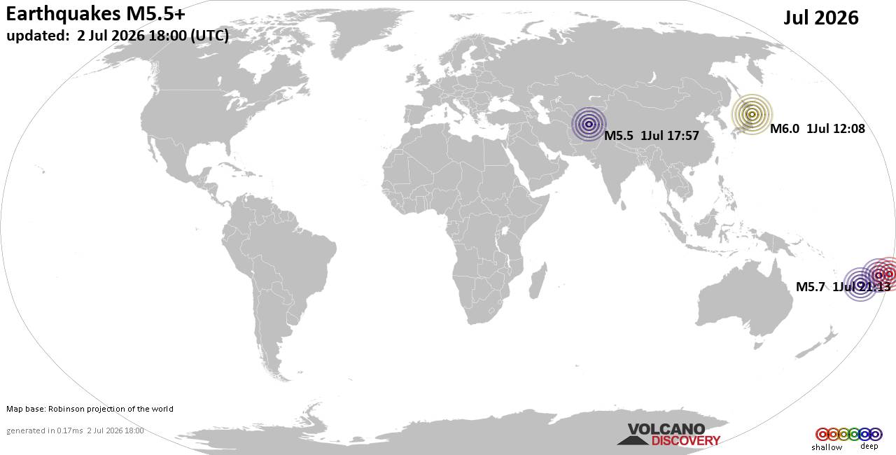 Worldwide earthquakes above magnitude 5.5 during July 2026 Magnitude 9+: none Magnitude 8+: none Magnitude 7+: 1 earthquake Magnitude 6+: 9 earthquakes Magnitude 5+: 181 earthquakes Magnitude 4+: 1562 earthquakes Magnitude 3+: 5115 earthquakes Magnitude 2+: 9826 earthquakes No quakes of magnitude 8 or higher List of 10 largest earthquakes in the world during July 2026:Friday, Jul 17, 2026, at 08:48 am (GMT -6) - Friday, Jul 17, 2026, at 09:20 am (GMT -6) - Monday, Jul 13, 2026, at 06:53 pm (GMT +10) - Saturday, Jul 11, 2026, at 08:26 am (GMT -2) - Tuesday, Jul 14, 2026, at 01:45 am (GMT +11) - Friday, Jul 3, 2026, at 11:31 am (Jayapura time) - Tuesday, Jul 14, 2026, at 11:49 pm (Manila time) - Friday, Jul 3, 2026, at 01:04 pm (GMT +9) - Wednesday, Jul 1, 2026, at 09:08 pm (GMT +9) - Thursday, Jul 16, 2026, at 10:14 pm (Auckland time) - Earthquake stats: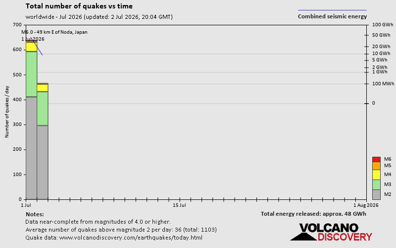 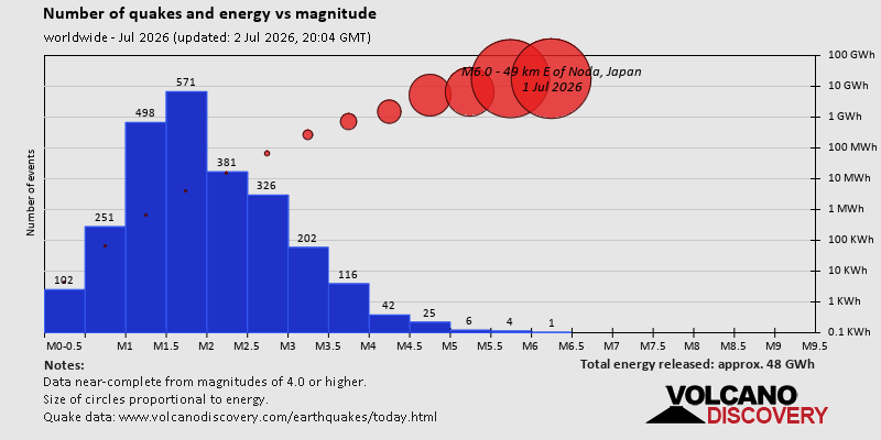 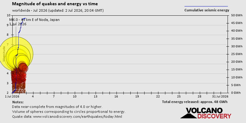 https://www.volcanodiscovery.com/view_news/318265/World-Earthquake-Report-for-July-2026.html https://www.volcanodiscovery.com/view_news/318265/World-Earthquake-Report-for-July-2026.html
0
12
Read More
|
Small 3.3 quake hits near Amaliada, Ilia Prefecture, West Greece, Greece
Webmaster
Yesterday at 03:40 PM
Small 3.3 quake hits near Amaliada, Ilia Prefecture, West Greece, Greece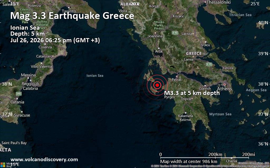 Just 13 minutes ago, a 3.3-magnitude earthquake struck near Amaliada, Ilia Prefecture, West Greece, Greece. The tremor was recorded early evening on Sunday, July 26th, 2026, at 6:25 pm local time, at a very shallow depth of 5. km below the surface.
The event was filed by the European-Mediterranean Seismological Centre (EMSC), the first seismological agency to report it.
Our monitoring service identified a second report from the National Observatory of Athens (NOA) which listed the quake at magnitude 3.2. Other agencies reporting the same quake include The Aristotle University of Thessaloniki Geophysical Lab. (AUTH) at magnitude 3.1, The Seismological Laboratory of the University of Athens (UOA) at magnitude 3.1, and the citizen-seismograph network of RaspberryShake at magnitude 3.2.
Weak shaking might have been felt in Planos (pop. 740) located 17 km from the epicenter, Gaitanion (pop. 1,900) 19 km away, and Zakynthos (pop. 11,500) 20 km away.
Other towns or cities near the epicenter where the quake might have been felt as very weak shaking include Vartholomio (pop. 3,100) located 26 km from the epicenter, Lechaina (pop. 3,700) 29 km away, Gastouni (pop. 8,100) 30 km away, and Amaliada (pop. 16,800) 41 km away. In Argostoli (pop. 9,800, 46 km away), and Pyrgos (pop. 22,400, 55 km away), the quake was probably not felt.
Earthquake data: Date & time: Jul 26, 2026 06:25 pm (GMT +3) local time (26 Jul 2026 15:25 GMT)Magnitude: 3.3 Depth: 5.00 km Epicenter latitude / longitude: 37.96°N / 20.93°E  ( Greece) Primary data source: EMSChttps://www.volcanodiscovery.com/earthquake/news/321084/Small-33-quake-hits-near-Amaliada-Ilia-Prefecture-West-Greece-Greece.html
0
14
Read More
|
|
Forums60
Topics792,815
Posts827,597
Members2,960
| |
Most Online102,106
Jul 10th, 2026
|
|
|
|
|
Copyright 1996 - 2026 by David Cottle. Designed by David Bate Jr. All Rights Reserved.
By using this forum, the user agrees not to transfer any data or technical information received under this agreement to any other entity without the express approval of the AUS-CITY Forum Admins and/or authors of individual posts (Forum Admins and DoD/USSPACECOM for the analysis of satellite tracking data).
Two-line elements (TLE) and all other satellite data presented and distributed via this forum and AUS-CITY mailing lists are distributed with permission from DoD/USSTRATCOM.


|

|


 - Click image for larger picture.")


