|
|
|
0 members (),
498
guests, and
24
robots. |
|
Key:
Admin,
Global Mod,
Mod
|
|
S |
M |
T |
W |
T |
F |
S |
|
|
|
|
|
1
|
2
|
3
|
|
4
|
5
|
6
|
7
|
8
|
9
|
10
|
|
11
|
12
|
13
|
14
|
15
|
16
|
17
|
|
18
|
19
|
20
|
21
|
22
|
23
|
24
|
|
25
|
26
|
27
|
28
|
29
|
30
|
31
|
|
There are no members with birthdays on this day. |
 Volcano earthquake report for Saturday, 10 May 2025
Webmaster
Yesterday at 11:50 PM
Volcano earthquake report for Saturday, 10 May 2025
Webmaster
Yesterday at 11:50 PM
Volcano earthquake report for Saturday, 10 May 2025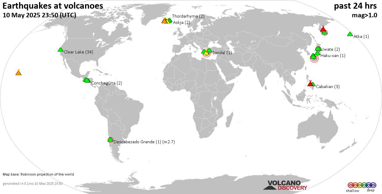 World map showing volcanoes with shallow (less than 50 km) earthquakes within 20 km radius during the past 24 hours on 10 May 2025 Number in brackets indicate nr of quakes. Quakes detected near: Abu (30 quakes between mag 0.3-1.5), Akademia Nauk (1 quake mag 2.4), Askja (2 quakes between mag 0.3-1.5), Atka (1 quake mag 1.0), Cabalian (3 quakes between mag 1.5-1.8), Canlaon (5 quakes between mag 2.0-3.1)
Clear Lake (34 quakes between mag 0.3-1.5), Conchagüita (2 quakes between mag 1.7-2.1), Cuilapa-Barbarena (1 quake mag 2.0), Descabezado Grande (1 quake mag 2.7), Haku-san (1 quake mag 1.0), Ilopango (1 quake mag 2.4), Iwate (2 quakes between mag 0.4-1.0), Katla (1 quake mag 1.6), Kilauea (1 quake mag 1.6), Kolumbo (13 quakes between mag 1.1-3.1), Krísuvík (4 quakes between mag 0.1-1.5), Ljósufjöll (11 quakes between mag 0.2-1.4), Megata (1 quake mag 2.6), Methana (2 quakes between mag 1.3-1.8), Sandal (1 quake mag 1.2), Santorini (3 quakes between mag 1.2-1.5), Shiveluch (1 quake mag 1.6), Svartsengi (9 quakes between mag 0.1-1.0), Thordarhyrna (2 quakes between mag 0.8-1.0), Tindfjallajökull (1 quake mag 1.3), Torfajökull (2 quakes between mag 0.8-1.5), Tsurumi (3 quakes between mag 0.2-3.0), Udina (1 quake mag 1.0) (updated 23h50)
Note: Earthquakes within 20 km from and at depths less than 50 km under active volcanoes are reported. The list is not complete because many volcanoes are not monitored and/or seismic data in high resolution is not available publicly.
Volcanoes with recent earthquakes above magnitude 2 or more than 10 quakes are listed below:
Abu volcano (Honshu): 30 earthquakes up to magnitude 1.5Possible earthquake swarm: 30 earthquakes occurred near (under) the volcano during 21 hours, the last being recorded quake 1 hour 34 minutes ago. Hypocenter depths ranged between 27.20 and 24.60 km. Earthquake details: (only 5 largest) 1.5 quake 37 km north of Yamaguchi, Yamaguchi, Japan, May 10, 2025 11:46 am (GMT +9) (3 km W) 1.1 quake 37 km north of Yamaguchi, Yamaguchi, Japan, May 10, 2025 10:30 am (GMT +9) (3 km W) 1.1 quake 38 km north of Yamaguchi, Yamaguchi, Japan, May 11, 2025 06:25 am (GMT +9) (3 km WNW) 1.1 quake 38 km north of Yamaguchi, Yamaguchi, Japan, May 11, 2025 06:46 am (GMT +9) (3 km NW) 1.1 quake 37 km north of Yamaguchi, Yamaguchi, Japan, May 10, 2025 12:33 pm (GMT +9) (3 km W) All earthquakes at AbuAkademia Nauk volcano (Kamchatka): magnitude 2.4 earthquakeA magnitude 2.4 earthquake occurred at the volcano 23 hours ago. The quake, which might be volcanic in origin, was located at a depth of 7.23 km depth at 6 km distance S from the volcano. Earthquake details: 2.4 quake 110 km northeast of Petropavlovsk-Kamchatskiy, Kamchatka, Russia, May 10, 2025 12:32 pm (Kamchatka time) (6 km S) All earthquakes at Akademia NaukCanlaon volcano (Central Philippines): 5 earthquakes up to magnitude 3.15 earthquakes occurred near (under) the volcano during 55 minutes, the last being recorded quake 3 hours ago. Hypocenter depths ranged between 17.00 and 2.00 km. Earthquake details: 3.1 quake Province of Negros Occidental, Western Visayas, 8.4 km northwest of Canlaon, Philippines, May 11, 2025 05:00 am (GMT +8) (7 km NE) 2.7 quake 25 km southeast of Mansilingan, Philippines, May 11, 2025 05:16 am (GMT +8) (5 km NNW) 2.4 quake 16 km north of Tinongan, Philippines, May 11, 2025 05:07 am (GMT +8) (9 km SW) 2.3 quake Province of Negros Occidental, Western Visayas, 10.3 km northwest of Canlaon, Philippines, May 11, 2025 04:21 am (GMT +8) (2 km NNE) 2.0 quake 2.9 km north of La Castellana, Philippines, May 11, 2025 04:57 am (GMT +8) (14 km WSW) All earthquakes at CanlaonClear Lake volcano (California): 34 earthquakes up to magnitude 1.5Possible earthquake swarm: 34 earthquakes occurred near (under) the volcano during 20 hours, the last being recorded quake 2 hours ago. Hypocenter depths ranged between 8.32 and 0.93 km. Earthquake details: (only 5 largest) 1.5 quake Sonoma County, 13 mi southwest of Clearlake, Lake County, California, United States, May 10, 2025 01:57 pm (GMT -7) (16 km SSW) 1.5 quake 27 mi north of Santa Rosa, Sonoma County, California, United States, May 10, 2025 01:15 am (GMT -7) (17 km SSW) 1.1 quake 28 mi north of Santa Rosa, Sonoma County, California, United States, May 10, 2025 12:40 am (GMT -7) (16 km SSW) 1.1 quake Lake County, 28 mi north of Santa Rosa, Sonoma County, California, United States, May 10, 2025 11:56 am (GMT -7) (15 km SSW) 1.1 quake 27 mi north of Santa Rosa, Sonoma County, California, United States, May 10, 2025 02:37 am (GMT -7) (17 km SSW) All earthquakes at Clear LakeConchagüita volcano (El Salvador): 2 earthquakes up to magnitude 2.12 earthquakes occurred near (under) the volcano during 2 hours, the last being recorded quake 19 hours ago. Hypocenter depths ranged between 7.00 and 5.00 km. Earthquake details: 2.1 quake 9 km south of La Union, Departamento de La Union, El Salvador, May 9, 2025 09:03 pm (GMT -6) (11 km WNW) 1.7 quake 6.1 km south of La Union, Departamento de La Union, El Salvador, May 9, 2025 11:19 pm (GMT -6) (9 km NW) All earthquakes at ConchagüitaDescabezado Grande volcano (Central Chile and Argentina): magnitude 2.7 earthquakeA magnitude 2.7 earthquake occurred at the volcano 18 hours ago. The quake, which might be volcanic in origin, was located at a depth of 22.00 km depth at 1 km distance WNW from the volcano. Earthquake details: 2.7 quake 82 km east of Talca, Talca, Region del Maule, Chile, May 10, 2025 02:04 am (GMT -4) (1 km WNW) All earthquakes at Descabezado GrandeIlopango volcano (El Salvador): magnitude 2.4 earthquakeA magnitude 2.4 earthquake occurred at the volcano 20 hours ago. The quake, which might be volcanic in origin, was located at a depth of 10.00 km depth at 2 km distance ENE from the volcano. Earthquake details: 2.4 quake 16 km east of San Salvador, Departamento de San Salvador, El Salvador, May 9, 2025 09:40 pm (GMT -6) (2 km ENE) All earthquakes at IlopangoKolumbo volcano (Greece): 13 earthquakes up to magnitude 3.1Possible earthquake swarm: 13 earthquakes occurred near (under) the volcano during 23 hours, the last being recorded quake 13 minutes ago. Hypocenter depths ranged between 19.10 and 5.00 km. Earthquake details: (only 5 largest) 3.1 quake Aegean Sea, 19 km northeast of Santorini Island, Greece, May 11, 2025 02:37 am (GMT +3) (9 km ENE) 3.0 quake Aegean Sea, 6.6 km north of Santorini Island, Greece, May 10, 2025 11:22 pm (GMT +3) (7 km SSW) 1.9 quake Aegean Sea, 20 km northeast of Santorini Island, Greece, May 11, 2025 02:13 am (GMT +3) (10 km ENE) 1.9 quake Aegean Sea, 24 km northeast of Santorini Island, Greece, May 11, 2025 01:53 am (GMT +3) (14 km ENE) 1.9 quake Aegean Sea, 30 km northeast of Oia, Nomos Kykladon, South Aegean, Greece, May 10, 2025 11:54 pm (GMT +3) (19 km NE) All earthquakes at KolumboLjósufjöll volcano (Iceland): 11 earthquakes up to magnitude 1.4Possible earthquake swarm: 11 earthquakes occurred near (under) the volcano during 7 hours, the last being recorded quake 10 hours ago. Hypocenter depths ranged between 20.30 and 9.80 km. Earthquake details: (only 5 largest) 1.4 quake 28.0 km N of Borgarnes May 10, 2025 07:53 am (Universal Time) (16 km ESE) 1.3 quake 23.8 km N of Borgarnes May 10, 2025 07:19 am (Universal Time) (19 km SE) 1.0 quake 28.0 km N of Borgarnes May 10, 2025 06:23 am (Universal Time) (15 km ESE) 0.7 quake Iceland: 27.9 km N of Borgarnes May 10, 2025 08:14 am (Reykjavik time) (15 km ESE) 0.7 quake Iceland: 28.2 km N of Borgarnes May 10, 2025 06:37 am (Reykjavik time) (15 km ESE) All earthquakes at LjósufjöllMegata volcano (Honshu): magnitude 2.6 earthquakeA magnitude 2.6 earthquake occurred at the volcano 5 hours ago. The quake, which might be volcanic in origin, was located at a depth of 11.80 km depth at 16 km distance S from the volcano. Earthquake details: 2.6 quake Sea of Japan, 34 km west of Akita, Akita, Japan, May 11, 2025 03:58 am (GMT +9) (16 km S) All earthquakes at MegataTsurumi volcano (Kyushu): 3 earthquakes up to magnitude 3.03 earthquakes occurred near (under) the volcano during 4 hours, the last being recorded quake 3 hours ago. Hypocenter depths ranged between 10.00 and 3.70 km. Earthquake details: Reported seismic-like event (likely no quake): 29 km southeast of Hyuga, Miyazaki, Japan, May 11, 2025 01:18 am (GMT +9) (7 km SSE) 0.8 quake 7.6 km west of Beppu, Oita Prefecture, Japan, May 11, 2025 05:26 am (GMT +9) (3 km NNW) 0.2 quake 18 km northwest of Oita, Oita Prefecture, Japan, May 11, 2025 05:30 am (GMT +9) (3 km NNW) All earthquakes at Tsurumihttps://www.volcanodiscovery.com/earthquakes-volcanoes/news/271125/Volcano-earthquake-report-for-Saturday-10-May-2025.html
0
7
Read More
|
World Earthquake Report for Saturday, 10 May 2025
Webmaster
Yesterday at 11:20 PM
World Earthquake Report for Saturday, 10 May 2025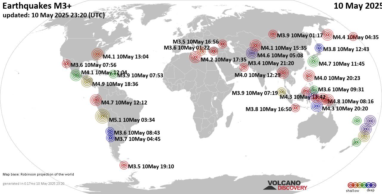 Worldwide earthquakes above magnitude 3 during the past 24 hours on 10 May 2025 Magnitude 5+: 1 earthquake Magnitude 4+: 36 earthquakes Magnitude 3+: 144 earthquakes Magnitude 2+: 305 earthquakes No quakes of magnitude 6 or higher 10 largest earthquakes in the world (past 24 hours)Friday, May 9, 2025, at 10:34 pm (GMT -5) - Saturday, May 10, 2025, at 12:36 pm (GMT -6) - Saturday, May 10, 2025, at 12:39 pm (GMT +12) - Saturday, May 10, 2025, at 05:16 pm (Jayapura time) - Saturday, May 10, 2025, at 12:50 pm (Managua time) - Saturday, May 10, 2025, at 07:12 am (Guayaquil time) - Saturday, May 10, 2025, at 08:45 pm (GMT +9) - Saturday, May 10, 2025, at 09:38 am (GMT +4:30) - #9: Mag 4.6 FijiSaturday, May 10, 2025, at 12:40 pm (GMT +12) - Friday, May 9, 2025, at 01:06 pm (GMT -12) - Earthquakes reported feltSaturday, May 10, 2025, at 09:04 am (GMT -4) - Saturday, May 10, 2025, at 09:35 pm (GMT +6) - Saturday, May 10, 2025, at 07:51 am (GMT +3) - Saturday, May 10, 2025, at 06:35 pm (GMT +1) - Saturday, May 10, 2025, at 07:12 am (Guayaquil time) - Saturday, May 10, 2025, at 12:50 pm (Managua time) - Saturday, May 10, 2025, at 09:38 am (GMT +4:30) - Saturday, May 10, 2025, at 04:22 am (Istanbul time) - Saturday, May 10, 2025, at 07:56 pm (GMT +3) - Friday, May 9, 2025, at 10:10 pm (GMT -5) - Saturday, May 10, 2025, at 06:07 pm (GMT +6:30) - Saturday, May 10, 2025, at 07:55 am (GMT +3) - Saturday, May 10, 2025, at 12:36 pm (GMT -6) - Saturday, May 10, 2025, at 01:19 pm (GMT +9) - Saturday, May 10, 2025, at 07:45 am (GMT -4) - Saturday, May 10, 2025, at 06:54 pm (GMT +7) - Saturday, May 10, 2025, at 06:59 pm (GMT +6:30) - Earthquake stats   https://www.volcanodiscovery.com/earthquake/news/271138/World-Earthquake-Report-for-Saturday-10-May-2025.html https://www.volcanodiscovery.com/earthquake/news/271138/World-Earthquake-Report-for-Saturday-10-May-2025.html
0
9
Read More
|
World Earthquake Report for May 2025
Webmaster
Yesterday at 06:00 PM
World Earthquake Report for May 2025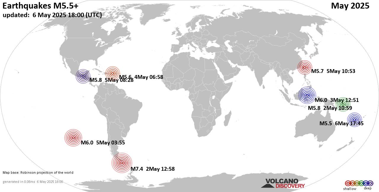 Worldwide earthquakes above magnitude 5.5 during May 2025 Magnitude 9+: none Magnitude 8+: none Magnitude 7+: 1 earthquake Magnitude 6+: 3 earthquakes Magnitude 5+: 53 earthquakes Magnitude 4+: 402 earthquakes Magnitude 3+: 1947 earthquakes Magnitude 2+: 3597 earthquakes No quakes of magnitude 8 or higher List of 10 largest earthquakes in the world during May 2025:Friday, May 2, 2025, at 09:58 am (GMT -3) - Friday, May 2, 2025, at 09:59 pm (GMT +11) - Friday, May 2, 2025, at 10:09 am (GMT -3) - Friday, May 2, 2025, at 10:10 am (GMT -3) - Earthquake stats:   https://www.volcanodiscovery.com/view_news/270585/World-Earthquake-Report-for-May-2025.html https://www.volcanodiscovery.com/view_news/270585/World-Earthquake-Report-for-May-2025.html
0
9
Read More
|
Seismic-like event, possible earthquake, reported few minutes ago near Almaty, Almaty, Kazakhstan
Webmaster
Yesterday at 03:40 PM
Seismic-like event, possible earthquake, reported few minutes ago near Almaty, Almaty, Kazakhstan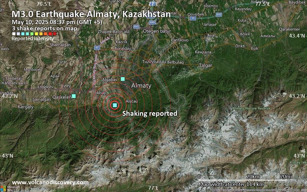 Unconfirmed quake or seismic-like event reported: 12 km southwest of Almaty, Almaty, Kazakhstan, 3 minutes ago We are receiving unverified early reports of ground shaking possibly caused by seismic activity in or near Almaty, Almaty, Kazakhstan on 10 May 2025 (GMT) at approximately 15:37 GMT.
There are no details yet on the magnitude or depth of this possible quake. If confirmed, we can expect more accurate data to emerge in the next few minutes. The location, magnitude and time mentioned are indicative, based on our best-fit seismic model. They are temporary until our AllQuakes monitoring service receives more exact scientific data from a national or international seismological agency. Check back here shortly and stay safe.
Earthquake data: Date & time: May 10, 2025 08:37 pm (GMT +5) local time (10 May 2025 15:37 GMT)Magnitude: unspecified Depth: unspecified Epicenter latitude / longitude: 43.17°N / 76.82°E  ( Almaty, Kazakhstan) Primary data source: VolcanoDiscoveryhttps://www.volcanodiscovery.com/earthquake/news/271173/Seismic-like-event-possible-earthquake-reported-few-minutes-ago-near-Almaty-Almaty-Kazakhstan.html
0
1
Read More
|
Seismic-like event, possible earthquake, reported about 10 minutes ago near Atlanta, Georgia, USA
Webmaster
Yesterday at 01:46 PM
Seismic-like event, possible earthquake, reported about 10 minutes ago near Atlanta, Georgia, USA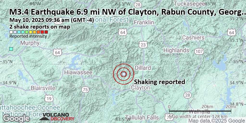 Unconfirmed earthquake or seismic-like event: 20 mi southwest of Andrews, Cherokee County, North Carolina, United States, 10 minutes ago We are receiving unverified early reports of ground shaking possibly caused by seismic activity in or near Atlanta, Georgia, USA on 10 May 2025 (GMT) at approximately 13:36 GMT.
There are no details yet on the magnitude or depth of this possible quake. If confirmed, we can expect more accurate data to emerge in the next few minutes. The location, magnitude and time mentioned are indicative, based on our best-fit seismic model. They are temporary until our AllQuakes monitoring service receives more exact scientific data from a national or international seismological agency. Check back here shortly and stay safe.
Earthquake data: Date & time: May 10, 2025 09:36 am (GMT -4) local time (10 May 2025 13:36 GMT)Magnitude: unspecified Depth: unspecified Epicenter latitude / longitude: 34.94°N / 83.5°W  ( Georgia, United States) Primary data source: VolcanoDiscoveryhttps://www.volcanodiscovery.com/earthquake/news/271169/Seismic-like-event-possible-earthquake-reported-about-10-minutes-ago-near-Atlanta-Georgia-USA.html
0
1
Read More
|
Seismic-like event, possible earthquake, reported few minutes ago near Sevierville, Tennessee, USA
Webmaster
Yesterday at 01:22 PM
Seismic-like event, possible earthquake, reported few minutes ago near Sevierville, Tennessee, USA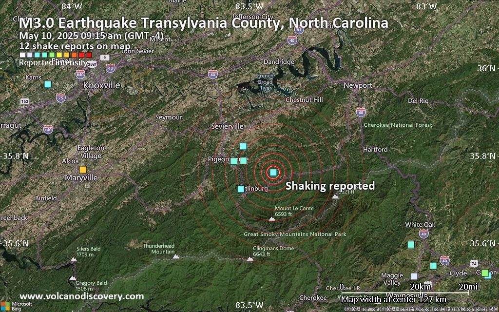 Unconfirmed earthquake or seismic-like event: Transylvania County, 5.3 mi northwest of Gastonia, Gaston County, North Carolina, United States, 7 minutes ago We are receiving unverified early reports of ground shaking possibly caused by seismic activity in or near Sevierville, Tennessee, USA on 10 May 2025 (GMT) at approximately 13:15 GMT.
There are no details yet on the magnitude or depth of this possible quake. If confirmed, we can expect more accurate data to emerge in the next few minutes. The location, magnitude and time mentioned are indicative, based on our best-fit seismic model. They are temporary until our AllQuakes monitoring service receives more exact scientific data from a national or international seismological agency. Check back here shortly and stay safe.
Earthquake data: Date & time: May 10, 2025 09:15 am (GMT -4) local time (10 May 2025 13:15 GMT)Magnitude: unspecified Depth: unspecified Epicenter latitude / longitude: 35.76°N / 83.43°W ( Gaston County, North Carolina, United States) Primary data source: VolcanoDiscoveryhttps://www.volcanodiscovery.com/earthquake/news/271167/Seismic-like-event-possible-earthquake-reported-few-minutes-ago-near-Sevierville-Tennessee-USA.html
0
1
Read More
|
Moderate magnitude 4.1 earthquake 29 miles south of Knoxville, Tennessee, United States
Webmaster
Yesterday at 01:19 PM
Moderate magnitude 4.1 earthquake 29 miles south of Knoxville, Tennessee, United States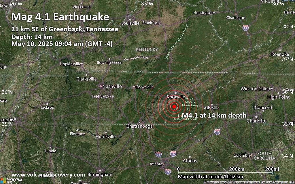 An earthquake of magnitude 4.1 occurred in the morning on Saturday, May 10th, 2025, at 9:04 am local time near Knoxville, Knox County, Tennessee, USA, as reported by the United States Geological Survey.
According to preliminary data, the quake was located at a shallow depth of 8.7 miles. Shallow earthquakes are felt more strongly than deeper ones as they are closer to the surface. The exact magnitude, epicenter, and depth of the quake might be revised within the next few hours or minutes as seismologists review data and refine their calculations, or as other agencies issue their report.
Our monitoring service identified a second report from the European-Mediterranean Seismological Centre (EMSC) which listed the quake at magnitude 3.8. A third agency, the European-Mediterranean Seismological Centre (EMSC), reported the same quake at magnitude 3.8.
Based on the preliminary seismic data, the quake should not have caused any significant damage, but was probably felt by many people as light vibration in the area of the epicenter.
Weak shaking might have been felt in Greenback (pop. 1,100) located 13 miles from the epicenter, Maryville (pop. 28,500) 14 miles away, and Alcoa (pop. 9,300) 17 miles away.
Other towns or cities near the epicenter where the quake might have been felt as very weak shaking include Lenoir City (pop. 9,100) located 23 miles from the epicenter, Farragut (pop. 21,900) 25 miles away, Knoxville (pop. 185,300) 29 miles away, Sevierville (pop. 16,500) 32 miles away, and Oak Ridge (pop. 29,300) 36 miles away.
Earthquake data: Date & time: May 10, 2025 09:04 am (GMT -4) local time (10 May 2025 13:04 GMT)Magnitude: 4.1 Depth: 14.06 km Epicenter latitude / longitude: 35.55°N / 83.98°W ( Blount County, Tennessee, United States) Primary data source: USGShttps://www.volcanodiscovery.com/earthquake/news/271165/Moderate-magnitude-41-earthquake-29-miles-south-of-Knoxville-Tennessee-United-States.html
0
1
Read More
|
Moderate tremor of magnitude 4.1 just reported 29 miles south of Knoxville, Tennessee, United States
Webmaster
Yesterday at 01:16 PM
Moderate tremor of magnitude 4.1 just reported 29 miles south of Knoxville, Tennessee, United States Just 11 minutes ago, a 4.1-magnitude earthquake struck near Knoxville, Knox County, Tennessee, USA. The tremor was recorded in the morning on Saturday, May 10th, 2025, at 9:04 am local time, at a shallow depth of 8.7 miles below the surface.
The event was filed by the United States Geological Survey, the first seismological agency to report it.
Based on the preliminary seismic data, the quake should not have caused any significant damage, but was probably felt by many people as light vibration in the area of the epicenter.
Weak shaking might have been felt in Greenback (pop. 1,100) located 13 miles from the epicenter, Maryville (pop. 28,500) 14 miles away, and Alcoa (pop. 9,300) 17 miles away.
Other towns or cities near the epicenter where the quake might have been felt as very weak shaking include Lenoir City (pop. 9,100) located 23 miles from the epicenter, Farragut (pop. 21,900) 25 miles away, Knoxville (pop. 185,300) 29 miles away, Sevierville (pop. 16,500) 32 miles away, and Oak Ridge (pop. 29,300) 36 miles away.
Earthquake data: Date & time: May 10, 2025 09:04 am (GMT -4) local time (10 May 2025 13:04 GMT)Magnitude: 4.1 Depth: 14.06 km Epicenter latitude / longitude: 35.55°N / 83.98°W ( Blount County, Tennessee, United States) Primary data source: USGShttps://www.volcanodiscovery.com/earthquake/news/271163/Moderate-tremor-of-magnitude-41-just-reported-29-miles-south-of-Knoxville-Tennessee-United-States.html
0
1
Read More
|
Seismic-like event, possible earthquake, reported few minutes ago near Asheville, North Carolina, USA
Webmaster
Yesterday at 01:07 PM
Seismic-like event, possible earthquake, reported few minutes ago near Asheville, North Carolina, USA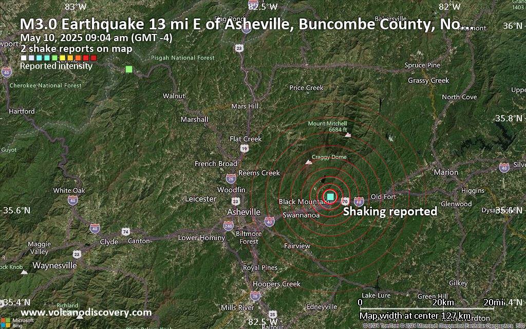 Unconfirmed earthquake or seismic-like event: 8.3 mi west of Knoxville, Knox County, Tennessee, United States, 3 minutes ago We are receiving unverified early reports of ground shaking possibly caused by seismic activity in or near Asheville, North Carolina, USA on 10 May 2025 (GMT) at approximately 13:04 GMT.
There are no details yet on the magnitude or depth of this possible quake. If confirmed, we can expect more accurate data to emerge in the next few minutes. The location, magnitude and time mentioned are indicative, based on our best-fit seismic model. They are temporary until our AllQuakes monitoring service receives more exact scientific data from a national or international seismological agency. Check back here shortly and stay safe.
Earthquake data: Date & time: May 10, 2025 09:04 am (GMT -4) local time (10 May 2025 13:04 GMT)Magnitude: unspecified Depth: unspecified Epicenter latitude / longitude: 35.63°N / 82.32°W ( North Carolina, United States) Primary data source: VolcanoDiscoveryhttps://www.volcanodiscovery.com/earthquake/news/271161/Seismic-like-event-possible-earthquake-reported-few-minutes-ago-near-Asheville-North-Carolina-USA.html
0
1
Read More
|
Significant earthquake of magnitude 5.5 just reported 3 km southeast of La Troncal, Ecuador
Webmaster
Yesterday at 12:40 PM
Significant earthquake of magnitude 5.5 just reported 3 km southeast of La Troncal, Ecuador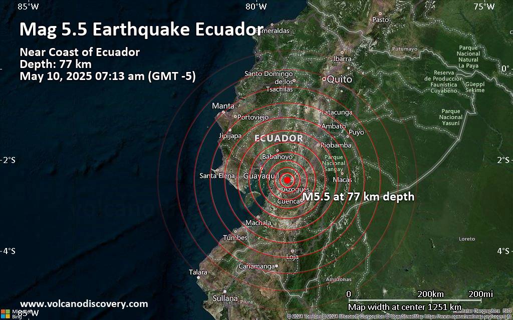 Ecuador was shaken near La Troncal, Canar, by an earthquake of magnitude 5.5 only 26 minutes ago, the European-Mediterranean Seismological Centre (EMSC) reported.
The quake hit at an intermediate depth of 77. km beneath the epicenter near La Troncal, Canar, Ecuador, in the morning on Saturday, May 10th, 2025, at 7:13 am local time. The exact magnitude, epicenter, and depth of the quake might be revised within the next few hours or minutes as seismologists review data and refine their calculations, or as other agencies issue their report.
A second report was later issued by the German Research Centre for Geosciences (GFZ), which listed it as a magnitude 4.8 earthquake. Other agencies reporting the same quake include the Institute of Geophysics of the National Polytechnic School in Quito (IGEPN) at magnitude 4.9, The Colombian Geological Service (SGC) at magnitude 4.7, and the citizen-seismograph network of RaspberryShake at magnitude 4.8.
Based on the preliminary seismic data, the quake should not have caused any significant damage, but was probably felt by many people as light vibration in the area of the epicenter.
Weak shaking might have been felt in La Troncal (pop. 36,400) located 3 km from the epicenter, Naranjito (pop. 34,200) 34 km away, Naranjal (pop. 32,000) 42 km away, Milagro (pop. 133,500) 46 km away, Yaguachi Nuevo (pop. 27,900) 56 km away, Eloy Alfaro (pop. 315,700) 65 km away, Guayaquil (pop. 2,723,700) 69 km away, Samborondon (pop. 24,100) 70 km away, and Daule (pop. 173,700) 98 km away.
VolcanoDiscovery will automatically update magnitude and depth if these change and follow up if other significant news about the quake become available. If you’re in the area, please send us your experience through our reporting mechanism, either online or via our mobile app. This will help us provide more first-hand updates to anyone around the globe who wants to know more about this quake.
Earthquake data: Date & time: May 10, 2025 07:13 am (Guayaquil time) local time (10 May 2025 12:13 GMT)Magnitude: 5.5 Depth: 77.00 km Epicenter latitude / longitude: 2.44°S / 79.32°W  ( Canar, Ecuador) Primary data source: EMSChttps://www.volcanodiscovery.com/earthquake/news/271157/Significant-earthquake-of-magnitude-55-just-reported-3-km-southeast-of-La-Troncal-Ecuador.html
0
1
Read More
|
Magnitude 4.8 earthquake strikes near Manokwari, Manokwari Regency, Provinsi Papua Barat, Indonesia
Webmaster
Yesterday at 08:25 AM
Magnitude 4.8 earthquake strikes near Manokwari, Manokwari Regency, Provinsi Papua Barat, Indonesia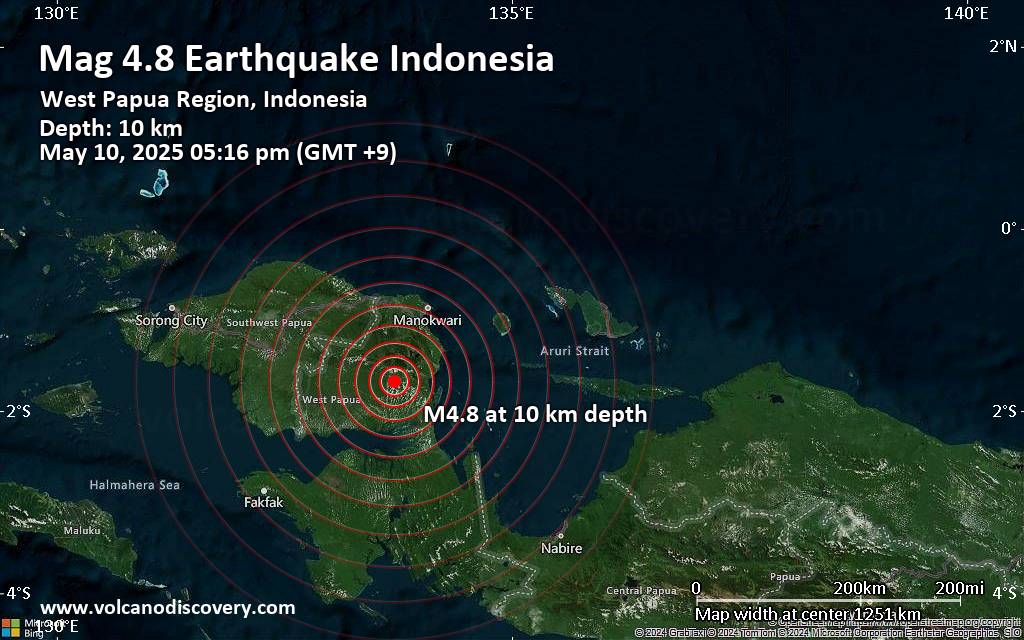 An earthquake of magnitude 4.8 occurred in the afternoon on Saturday, May 10th, 2025, at 5:16 pm local time near Manokwari, Manokwari Regency, Provinsi Papua Barat, Indonesia, as reported by Indonesia's Meteorology, Climatology, and Geophysical Agency.
According to preliminary data, the quake was located at a shallow depth of 10. km. Shallow earthquakes are felt more strongly than deeper ones as they are closer to the surface. The exact magnitude, epicenter, and depth of the quake might be revised within the next few hours or minutes as seismologists review data and refine their calculations, or as other agencies issue their report.
Based on the preliminary seismic data, the quake should not have caused any significant damage, but was probably felt by many people as light vibration in the area of the epicenter.
Weak shaking might have been felt in Bintuni (pop. 24,700) located 52 km from the epicenter, and Ransiki (pop. 16,200) 55 km away.
Other towns or cities near the epicenter where the quake might have been felt as very weak shaking include Manokwari (pop. 107,300) located 99 km from the epicenter.
VolcanoDiscovery will automatically update magnitude and depth if these change and follow up if other significant news about the quake become available. If you’re in the area, please send us your experience through our reporting mechanism, either online or via our mobile app. This will help us provide more first-hand updates to anyone around the globe who wants to know more about this quake.
Earthquake data: Date & time: May 10, 2025 05:16 pm (Jayapura time) local time (10 May 2025 08:16 GMT)Magnitude: 4.8 Depth: 10.00 km Epicenter latitude / longitude: 1.68°S / 133.71°E  ( Kabupaten Teluk Bintuni, Southwest Papua, Indonesia) Primary data source: BMKGhttps://www.volcanodiscovery.com/earthquake/news/271147/Magnitude-48-earthquake-strikes-near-Manokwari-Manokwari-Regency-Provinsi-Papua-Barat-Indonesia.html
0
1
Read More
|
|
Forums60
Topics725,841
Posts760,457
Members2,958
| |
Most Online4,158
Jun 21st, 2024
|
|
|
|
|
Copyright 1996 - 2024 by David Cottle. Designed by David Bate Jr. All Rights Reserved.
By using this forum, the user agrees not to transfer any data or technical information received under the agreement, to any other entity without the express approval of the AUS-CITY Forum Admins and/or authors of individual posts (Forum Admins and DoD/USSPACECOM for the analysis of satellite tracking data).
Two-line elements (TLE) and all other satellite data presented and distributed via this forum and e-mail lists of AUS-CITY are distributed with permission from DoD/USSTRATCOM.


Reprise Hosting

|

|


 - Click image for larger picture.")


