|
|
|
0 members (),
1,929
guests, and
16
robots. |
|
Key:
Admin,
Global Mod,
Mod
|
|
S |
M |
T |
W |
T |
F |
S |
|
|
|
|
1
|
2
|
3
|
4
|
|
5
|
6
|
7
|
8
|
9
|
10
|
11
|
|
12
|
13
|
14
|
15
|
16
|
17
|
18
|
|
19
|
20
|
21
|
22
|
23
|
24
|
25
|
|
26
|
27
|
28
|
29
|
30
|
31
|
|
|
There are no members with birthdays on this day. |
|
|
|
|
|
|
|
|
by Webmaster - Sun 26 Jul 2026 08:45:PM
|
by Webmaster - Sun 26 Jul 2026 08:45:PM
|
by Webmaster - Sun 26 Jul 2026 08:45:PM
|
|
|
|
|
|
|
|
|
|
|

World Earthquake Report for Sunday, 26 July 2026
• Moderate mag. 4.5 earthquake - Estado de Veracruz-Llave, Mexico, on 2026-07...
• Volcano earthquake report for Sunday, 26 Jul 2026
• Moderate mag. 4.0 earthquake - Kabupaten Kepulauan Talaud, 148 km northeast...
• Light mag. 3.9 earthquake - North Pacific Ocean, 65 km south of Puerto San ...
• Strong mag. 5.4 earthquake - Northern Mid-Atlantic Ridge on Sunday, Jul 26,...
|
 World Earthquake Report for Sunday, 26 July 2026
Webmaster
Yesterday at 08:20 PM
World Earthquake Report for Sunday, 26 July 2026
Webmaster
Yesterday at 08:20 PM
World Earthquake Report for Sunday, 26 July 2026Worldwide earthquakes above magnitude 3 during the past 24 hours on 26 Jul 2026 Magnitude 5+: 6 earthquakes Magnitude 4+: 52 earthquakes Magnitude 3+: 169 earthquakes Magnitude 2+: 361 earthquakes No quakes of magnitude 6 or higher 10 largest earthquakes in the world (past 24 hours)Saturday, Jul 25, 2026, at 08:35 pm (GMT -12) - Sunday, Jul 26, 2026, at 03:19 pm (GMT -3) - Sunday, Jul 26, 2026, at 06:57 pm (Makassar time) - Sunday, Jul 26, 2026, at 12:32 am (GMT -1) - Saturday, Jul 25, 2026, at 09:03 am (GMT -12) - Sunday, Jul 26, 2026, at 07:17 pm (GMT +12) - Sunday, Jul 26, 2026, at 09:39 am (GMT +12) - Sunday, Jul 26, 2026, at 08:36 pm (Taipei time) - Saturday, Jul 25, 2026, at 09:13 pm (Bogota time) - Sunday, Jul 26, 2026, at 03:26 am (GMT -6) - Earthquakes reported feltSunday, Jul 26, 2026, at 03:39 pm (GMT +2) - Sunday, Jul 26, 2026, at 06:25 pm (GMT +3) - Sunday, Jul 26, 2026, at 08:36 pm (Taipei time) - Saturday, Jul 25, 2026, at 09:13 pm (Bogota time) - Sunday, Jul 26, 2026, at 06:57 pm (Makassar time) - Sunday, Jul 26, 2026, at 09:43 am (GMT +2) - Sunday, Jul 26, 2026, at 04:11 pm (GMT +2) - Sunday, Jul 26, 2026, at 05:39 pm (GMT +9) - Saturday, Jul 25, 2026, at 03:36 pm (GMT -6) - Sunday, Jul 26, 2026, at 09:40 am (GMT +10) - Saturday, Jul 25, 2026, at 05:46 pm (GMT -4) - Sunday, Jul 26, 2026, at 05:39 am (Yangon time) - Saturday, Jul 25, 2026, at 08:35 pm (GMT -12) - Sunday, Jul 26, 2026, at 04:04 am (Guatemala time) - Sunday, Jul 26, 2026, at 07:17 pm (GMT +12) - Sunday, Jul 26, 2026, at 06:42 pm (GMT +8) - Sunday, Jul 26, 2026, at 06:23 am (GMT -5) - Sunday, Jul 26, 2026, at 09:36 am (Santiago time) - Sunday, Jul 26, 2026, at 11:17 pm (Manila time) - Earthquake stats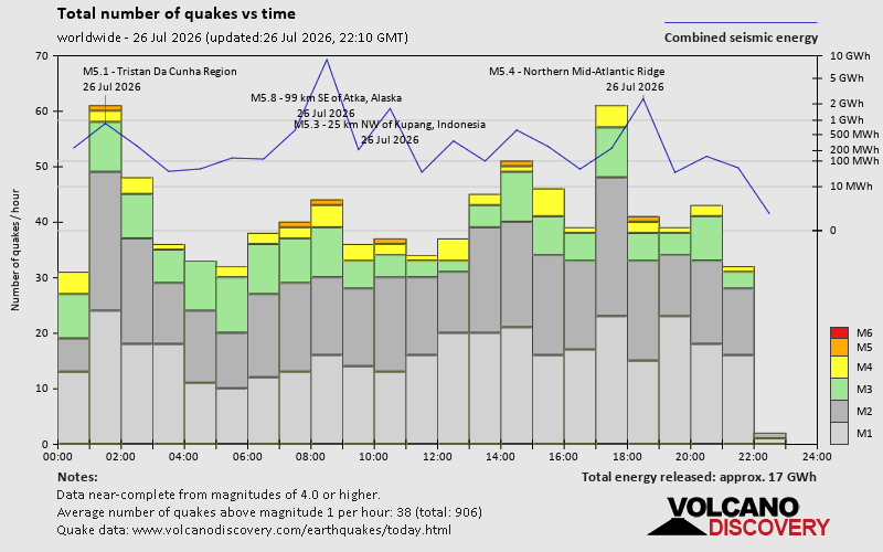 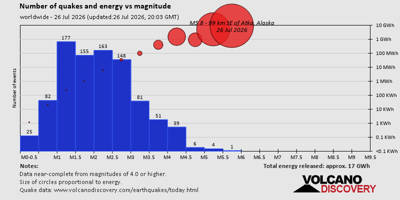 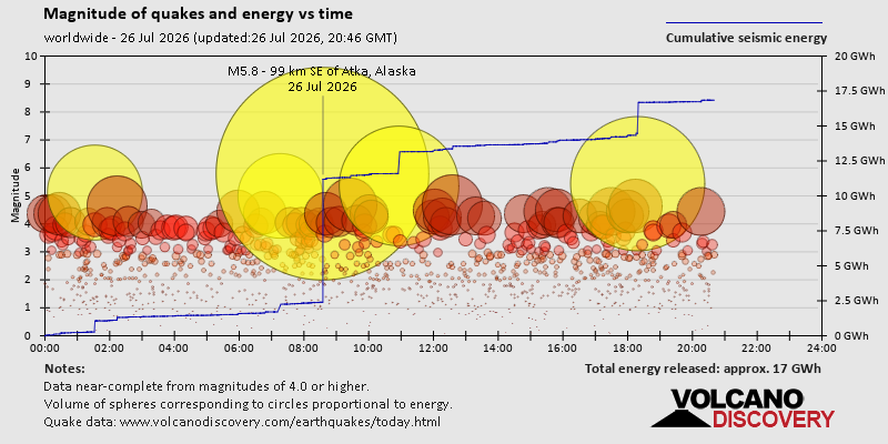 https://www.volcanodiscovery.com/earthquake/news/321044/World-Earthquake-Report-for-Sunday-26-July-2026.html https://www.volcanodiscovery.com/earthquake/news/321044/World-Earthquake-Report-for-Sunday-26-July-2026.html
0
21
Read More
|
Volcano earthquake report for Sunday, 26 Jul 2026
Webmaster
Yesterday at 07:50 PM
Volcano earthquake report for Sunday, 26 Jul 2026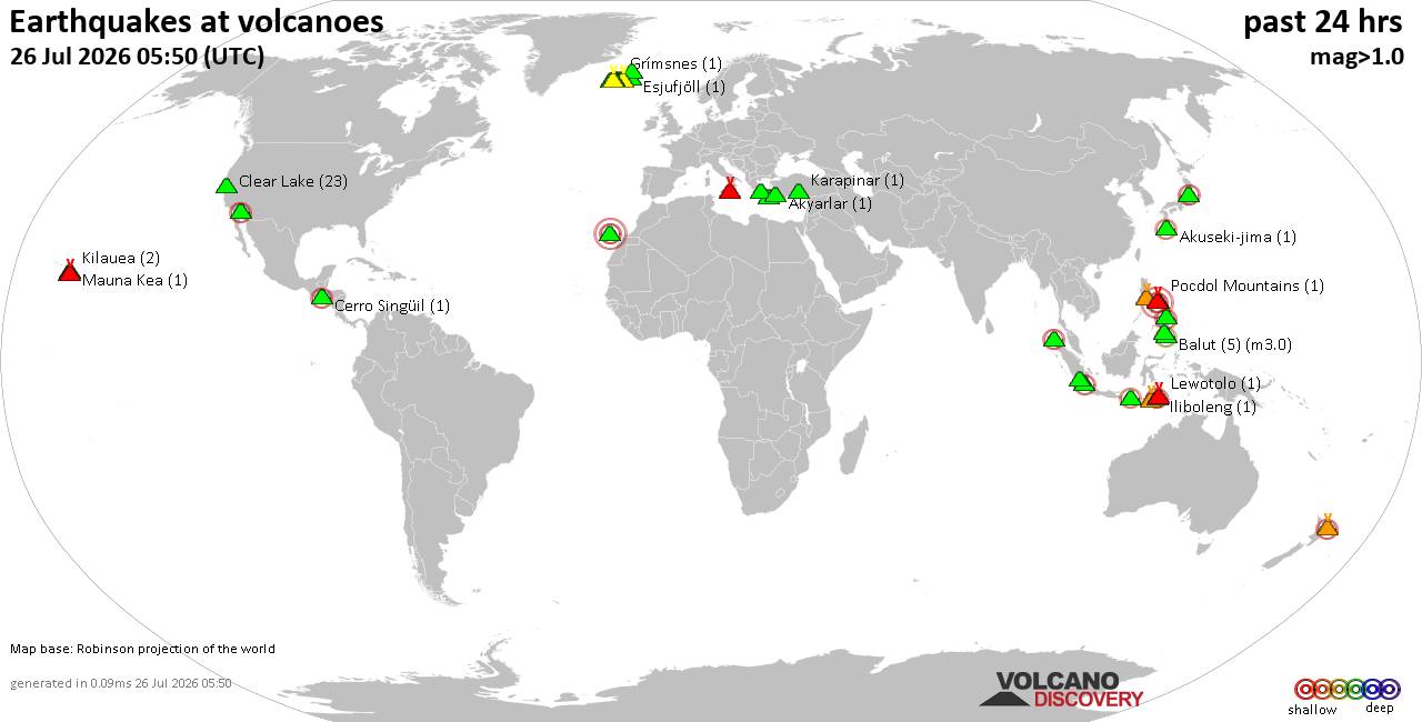 World map showing volcanoes with shallow (less than 50 km) earthquakes within 20 km radius during the past 24 hours on 26 Jul 2026 Number in brackets indicate nr of quakes. Quakes detected near: Akuseki-jima (1 quake mag 2.3), Balut (6 quakes between mag 1.4-3.0), Brennisteinsfjöll (3 quakes between mag 0.1-1.0), Cabalian (1 quake mag 2.2), Campi Flegrei (Phlegrean Fields) (15 quakes between mag 0.0-1.6), Clear Lake (23 quakes between mag 0.4-1.2)
Coso (4 quakes between mag 0.9-1.3), Don Joao de Castro Bank (1 quake mag 2.0), El Chichón (1 quake mag 2.6), Eldey (7 quakes between mag 0.6-1.9), Etna (1 quake mag 1.2), Fourpeaked (1 quake mag 1.6), Geureudong (1 quake mag 2.2), Grímsnes (1 quake mag 1.1), Hiuchi (1 quake mag 2.8), Hulubelu (3 quakes between mag 2.1-2.5), Karapinar (1 quake mag 1.5), Katla (4 quakes between mag 1.0-1.3), Kolumbo (2 quakes between mag 1.6-1.6), Krísuvík (5 quakes between mag 0.0-1.3), La Palma (2 quakes between mag 1.4-2.0), Loihi (1 quake mag 2.1), Mayon (1 quake mag 3.0), Mayotte Island (1 quake mag 1.3), Methana (1 quake mag 1.4), Naolinco (1 quake mag 3.2), Parker (1 quake mag 2.5), Patah (1 quake mag 3.0), Patoc (1 quake mag 2.2), Pinatubo (1 quake mag 1.6), Piparo (1 quake mag 3.0), Pocdol Mountains (2 quakes between mag 1.4-1.4), Rinjani (1 quake mag 2.6), Sangeang Api (1 quake mag 2.3), Santo Tomas (1 quake mag 1.8), Svartsengi (1 quake mag 1.1), Taal (1 quake mag 3.0), Taupo (1 quake mag 1.6), Tenerife (7 quakes between mag 0.8-1.3), Theistareykjarbunga (3 quakes between mag 0.6-1.0), White Island (1 quake mag 2.1) (updated 19h50)
Note: Earthquakes within 20 km from and at depths less than 50 km under active volcanoes are reported. The list is not complete because many volcanoes are not monitored and/or seismic data in high resolution is not available publicly.
Volcanoes with recent earthquakes above magnitude 2 or more than 10 quakes are listed below:
Akuseki-jima volcano (Ryukyu Islands): magnitude 2.3 earthquakeA magnitude 2.3 earthquake occurred at the volcano 19 hours ago. The quake, which might be volcanic in origin, was located at a depth of 20.00 km depth at 12 km distance SW from the volcano. Earthquake details: 2.3 quake Ryukyu Islands, Japan, Jul 26, 2026 10:04 am (GMT +9) (12 km SW) All earthquakes at Akuseki-jimaBalut volcano (Mindanao): 6 earthquakes up to magnitude 3.06 earthquakes occurred near (under) the volcano during 23 hours, the last being recorded quake 40 minutes ago. Hypocenter depths ranged between 40.00 and 10.00 km. Earthquake details: (only 5 largest) 3.0 quake Mindanao, Philippines, Jul 26, 2026 04:08 am (GMT +8) (5 km ENE) 2.4 quake Philippines: 006 km N 79° W of Sarangani Island (Municipality of Sarangani) (Davao Occidental) Jul 27, 2026 03:10 am (GMT +8) (10 km NNE) 2.1 quake 016 km S 73° W of Balut Island (Municipality of Sarangani) (Davao Occidental) Jul 26, 2026 07:48 pm (GMT +8) (11 km WSW) 1.7 quake 012 km N 80° W of Balut Island (Municipality of Sarangani) (Davao Occidental) Jul 26, 2026 05:41 pm (GMT +8) (8 km WNW) 1.5 quake Philippines: 019 km S 71° W of Balut Island (Municipality of Sarangani) (Davao Occidental) Jul 26, 2026 02:39 pm (GMT +8) (13 km WSW) All earthquakes at BalutCabalian volcano (Central Philippines): magnitude 2.2 earthquakeA magnitude 2.2 earthquake occurred at the volcano 10 hours ago. The quake, which might be volcanic in origin, was located at a depth of 13.00 km depth at 7 km distance SSW from the volcano. Earthquake details: 2.2 quake 003 km S 24° E of San Juan (Southern Leyte) Jul 26, 2026 05:38 pm (GMT +8) (7 km SSW) All earthquakes at CabalianCampi Flegrei (Phlegrean Fields) volcano (Italy): 15 earthquakes up to magnitude 1.6Possible earthquake swarm: 15 earthquakes occurred near (under) the volcano during 5 hours, the last being recorded quake 50 minutes ago. Hypocenter depths ranged between 2.44 and 0.43 km. Earthquake details: (only 5 largest) 1.6 quake Italy: Campi Flegrei Jul 26, 2026 05:00 pm (GMT +2) (1 km SSE) 1.2 quake Campi Flegrei Jul 26, 2026 04:58 pm (GMT +2) (1 km SSE) 1.1 quake Campi Flegrei Jul 26, 2026 09:00 pm (GMT +2) (1 km SSE) 1.1 quake Campi Flegrei Jul 26, 2026 05:00 pm (GMT +2) (1 km SSE) 1.1 quake Campi Flegrei Jul 26, 2026 04:58 pm (GMT +2) (8 km SSE) All earthquakes at Campi Flegrei (Phlegrean Fields)Clear Lake volcano (California): 23 earthquakes up to magnitude 1.2Possible earthquake swarm: 23 earthquakes occurred near (under) the volcano during 23 hours, the last being recorded quake 20 minutes ago. Hypocenter depths ranged between 12.30 and 1.38 km. Earthquake details: (only 5 largest) 1.2 quake 6 km NW of the Geysers, CA, Jul 26, 2026 12:16 pm (GMT -7) (17 km S) 1.2 quake 7 km NW of the Geysers, CA, Jul 26, 2026 10:04 am (GMT -7) (17 km SSW) 1.1 quake 6 km WNW of Cobb, CA, Jul 26, 2026 07:30 am (GMT -7) (15 km S) 1.1 quake 5 km NNW of the Geysers, CA, Jul 25, 2026 01:58 pm (GMT -7) (18 km S) 1.0 quake 6 km WNW of Cobb, CA, Jul 26, 2026 12:29 pm (GMT -7) (15 km S) All earthquakes at Clear LakeEl Chichón volcano (Southern Mexico): magnitude 2.6 earthquakeA magnitude 2.6 earthquake occurred at the volcano 19 hours ago. The quake, which might be volcanic in origin, was located at a depth of 2.50 km depth at 1 km distance SW from the volcano. Earthquake details: 2.6 quake Chiapas, Mexico, Jul 25, 2026 07:18 pm (GMT -6) (1 km SW) All earthquakes at El ChichónGeureudong volcano (Sumatra): magnitude 2.2 earthquakeA magnitude 2.2 earthquake occurred at the volcano 18 hours ago. The quake, which might be volcanic in origin, was located at a depth of 10.00 km depth at 12 km distance NNW from the volcano. Earthquake details: 2.2 quake Northern Sumatra, Indonesia, Jul 26, 2026 08:25 am (GMT +7) (12 km NNW) All earthquakes at GeureudongHiuchi volcano (Honshu): magnitude 2.8 earthquakeA magnitude 2.8 earthquake occurred at the volcano 1 hour 47 minutes ago. The quake, which might be volcanic in origin, was located at a depth of 10.00 km depth at 19 km distance NNE from the volcano. Earthquake details: 2.8 quake Eastern Honshu, Japan, Jul 27, 2026 03:03 am (GMT +9) (19 km NNE) All earthquakes at HiuchiHulubelu volcano (Sumatra): 3 earthquakes up to magnitude 2.53 earthquakes occurred near (under) the volcano during 6 minutes, the last being recorded quake 22 hours ago. Hypocenter depths ranged between 5.00 and 5.00 km. Earthquake details: 2.5 quake Southern Sumatra, Indonesia, Jul 26, 2026 04:41 am (GMT +7) (14 km SE) 2.4 quake Southern Sumatra, Indonesia, Jul 26, 2026 04:47 am (GMT +7) (12 km SE) 2.1 quake Southern Sumatra, Indonesia, Jul 26, 2026 04:42 am (GMT +7) (15 km SE) All earthquakes at HulubeluLoihi volcano (Hawai'i (Big Island)): magnitude 2.1 earthquakeA magnitude 2.1 earthquake occurred at the volcano 6 hours ago. The quake, which might be volcanic in origin, was located at a depth of 34.43 km depth at 18 km distance NW from the volcano. Earthquake details: 2.1 quake 20 km SSE of Pāhala, Hawaii, Jul 26, 2026 03:58 am (GMT -10) (18 km NW) All earthquakes at LoihiMayon volcano (Luzon Island): magnitude 3.0 earthquakeA magnitude 3.0 earthquake occurred at the volcano 15 hours ago. The quake, which might be volcanic in origin, was located at a depth of 10.00 km depth at 13 km distance SSE from the volcano. Earthquake details: Reported seismic-like event (likely no quake): Near Sorsogon, Bicol Region, Philippines, Jul 26, 2026 12:41 pm (GMT +8) (13 km SSE) All earthquakes at MayonNaolinco volcano (Western & Central Mexico): magnitude 3.2 earthquakeA magnitude 3.2 earthquake occurred at the volcano 13 hours ago. The quake, which might be volcanic in origin, was located at a depth of 8.00 km depth at 3 km distance SSE from the volcano. Earthquake details: 3.2 quake Veracruz, Mexico, Jul 26, 2026 12:50 am (GMT -6) (3 km SSE) All earthquakes at NaolincoParker volcano (Mindanao): magnitude 2.5 earthquakeA magnitude 2.5 earthquake occurred at the volcano 24 hours ago. The quake, which might be volcanic in origin, was located at a depth of 12.00 km depth at 16 km distance WSW from the volcano. Earthquake details: 2.5 quake 016 km S 28° W of T'Boli (South Cotabato) Jul 26, 2026 04:05 am (GMT +8) (16 km WSW) All earthquakes at ParkerPatah volcano (Sumatra): magnitude 3.0 earthquakeA magnitude 3.0 earthquake occurred at the volcano 17 hours ago. The quake, which might be volcanic in origin, was located at a depth of 14.00 km depth at 5 km distance SSW from the volcano. Earthquake details: 3.0 quake Southern Sumatra, Indonesia, Jul 26, 2026 09:35 am (GMT +7) (5 km SSW) All earthquakes at PatahPatoc volcano (Luzon Island): magnitude 2.2 earthquakeA magnitude 2.2 earthquake occurred at the volcano 7 hours ago. The quake, which might be volcanic in origin, was located at a depth of 35.00 km depth at 17 km distance SSE from the volcano. Earthquake details: 2.2 quake 010 km S 62° W of Barlig (Mountain Province) Jul 26, 2026 08:59 pm (GMT +8) (17 km SSE) All earthquakes at PatocPiparo volcano (Caribbean): magnitude 3.0 earthquakeA magnitude 3.0 earthquake occurred at the volcano 11 hours ago. The quake, which might be volcanic in origin, was located at a depth of 10.00 km depth at 0 km distance WSW from the volcano. Earthquake details: Reported seismic-like event (likely no quake): Near Maturin, Monagas, Venezuela, Jul 26, 2026 04:22 am (GMT -4) (0 km WSW) All earthquakes at PiparoRinjani volcano (Lombok): magnitude 2.6 earthquakeA magnitude 2.6 earthquake occurred at the volcano 19 hours ago. The quake, which might be volcanic in origin, was located at a depth of 10.00 km depth at 9 km distance N from the volcano. Earthquake details: 2.6 quake Sumbawa Region, Indonesia, Jul 26, 2026 09:17 am (GMT +8) (9 km N) All earthquakes at RinjaniSangeang Api volcano (Lesser Sunda Islands): magnitude 2.3 earthquakeA magnitude 2.3 earthquake occurred at the volcano 11 hours ago. The quake, which might be volcanic in origin, was located at a depth of 15.00 km depth at 14 km distance NNE from the volcano. Earthquake details: 2.3 quake Flores Region, Indonesia, Jul 26, 2026 04:41 pm (GMT +8) (14 km NNE) All earthquakes at Sangeang ApiTaal volcano (Luzon Island): magnitude 3.0 earthquakeA magnitude 3.0 earthquake occurred at the volcano 16 hours ago. The quake, which might be volcanic in origin, was located at a depth of 10.00 km depth at 10 km distance ENE from the volcano. Earthquake details: Reported seismic-like event (likely no quake): Near Calamba, Calabarzon, Philippines, Jul 26, 2026 11:30 am (GMT +8) (10 km ENE) All earthquakes at TaalWhite Island volcano (New Zealand): magnitude 2.1 earthquakeA magnitude 2.1 earthquake occurred at the volcano 18 hours ago. The quake, which might be volcanic in origin, was located at a depth of 12.00 km depth at 6 km distance W from the volcano. Earthquake details: 2.1 quake New Zealand Jul 26, 2026 01:46 pm (GMT +12) (6 km W) All earthquakes at White Islandhttps://www.volcanodiscovery.com/earthquakes-volcanoes/news/321039/Volcano-earthquake-report-for-Sunday-26-Jul-2026.html
0
21
Read More
|
World Earthquake Report for July 2026
Webmaster
Yesterday at 06:00 PM
World Earthquake Report for July 2026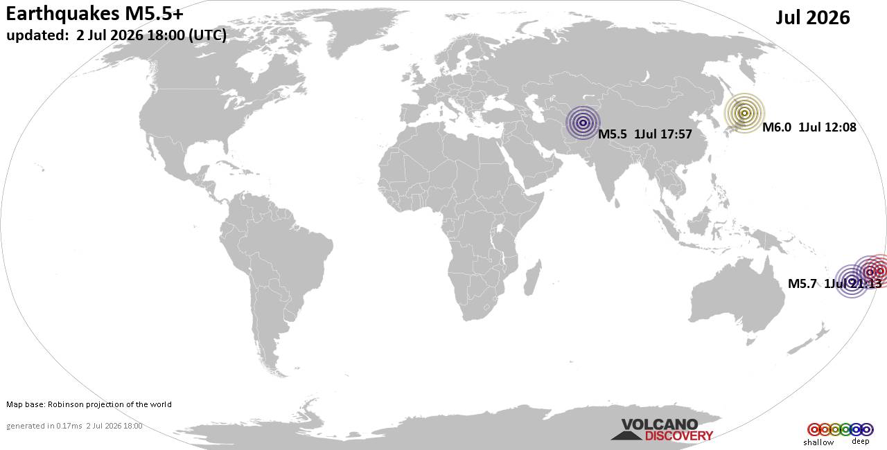 Worldwide earthquakes above magnitude 5.5 during July 2026 Magnitude 9+: none Magnitude 8+: none Magnitude 7+: 1 earthquake Magnitude 6+: 9 earthquakes Magnitude 5+: 181 earthquakes Magnitude 4+: 1562 earthquakes Magnitude 3+: 5115 earthquakes Magnitude 2+: 9826 earthquakes No quakes of magnitude 8 or higher List of 10 largest earthquakes in the world during July 2026:Friday, Jul 17, 2026, at 08:48 am (GMT -6) - Friday, Jul 17, 2026, at 09:20 am (GMT -6) - Monday, Jul 13, 2026, at 06:53 pm (GMT +10) - Saturday, Jul 11, 2026, at 08:26 am (GMT -2) - Tuesday, Jul 14, 2026, at 01:45 am (GMT +11) - Friday, Jul 3, 2026, at 11:31 am (Jayapura time) - Tuesday, Jul 14, 2026, at 11:49 pm (Manila time) - Friday, Jul 3, 2026, at 01:04 pm (GMT +9) - Wednesday, Jul 1, 2026, at 09:08 pm (GMT +9) - Thursday, Jul 16, 2026, at 10:14 pm (Auckland time) - Earthquake stats: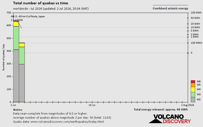 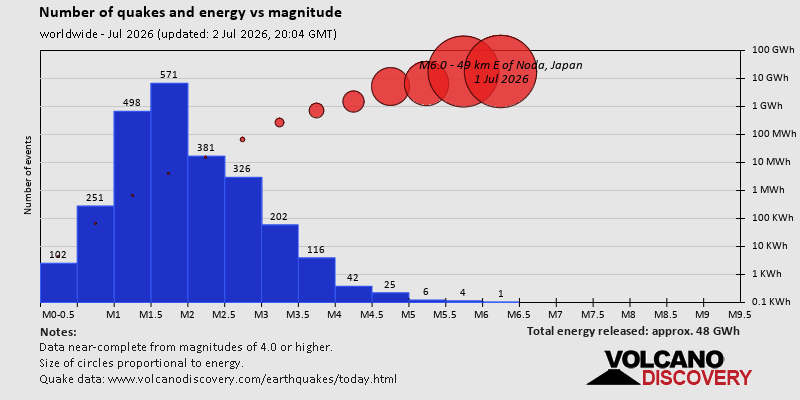 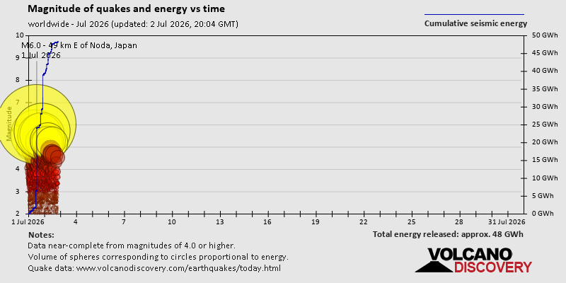 https://www.volcanodiscovery.com/view_news/318265/World-Earthquake-Report-for-July-2026.html https://www.volcanodiscovery.com/view_news/318265/World-Earthquake-Report-for-July-2026.html
0
5
Read More
|
Small 3.3 quake hits near Amaliada, Ilia Prefecture, West Greece, Greece
Webmaster
Yesterday at 03:40 PM
Small 3.3 quake hits near Amaliada, Ilia Prefecture, West Greece, Greece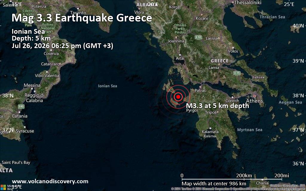 Just 13 minutes ago, a 3.3-magnitude earthquake struck near Amaliada, Ilia Prefecture, West Greece, Greece. The tremor was recorded early evening on Sunday, July 26th, 2026, at 6:25 pm local time, at a very shallow depth of 5. km below the surface.
The event was filed by the European-Mediterranean Seismological Centre (EMSC), the first seismological agency to report it.
Our monitoring service identified a second report from the National Observatory of Athens (NOA) which listed the quake at magnitude 3.2. Other agencies reporting the same quake include The Aristotle University of Thessaloniki Geophysical Lab. (AUTH) at magnitude 3.1, The Seismological Laboratory of the University of Athens (UOA) at magnitude 3.1, and the citizen-seismograph network of RaspberryShake at magnitude 3.2.
Weak shaking might have been felt in Planos (pop. 740) located 17 km from the epicenter, Gaitanion (pop. 1,900) 19 km away, and Zakynthos (pop. 11,500) 20 km away.
Other towns or cities near the epicenter where the quake might have been felt as very weak shaking include Vartholomio (pop. 3,100) located 26 km from the epicenter, Lechaina (pop. 3,700) 29 km away, Gastouni (pop. 8,100) 30 km away, and Amaliada (pop. 16,800) 41 km away. In Argostoli (pop. 9,800, 46 km away), and Pyrgos (pop. 22,400, 55 km away), the quake was probably not felt.
Earthquake data: Date & time: Jul 26, 2026 06:25 pm (GMT +3) local time (26 Jul 2026 15:25 GMT)Magnitude: 3.3 Depth: 5.00 km Epicenter latitude / longitude: 37.96°N / 20.93°E  ( Greece) Primary data source: EMSChttps://www.volcanodiscovery.com/earthquake/news/321084/Small-33-quake-hits-near-Amaliada-Ilia-Prefecture-West-Greece-Greece.html
0
7
Read More
|
Magnitude 4.7 earthquake strikes near Taipei, Taipei City, Taiwan
Webmaster
Yesterday at 12:58 PM
Magnitude 4.7 earthquake strikes near Taipei, Taipei City, Taiwan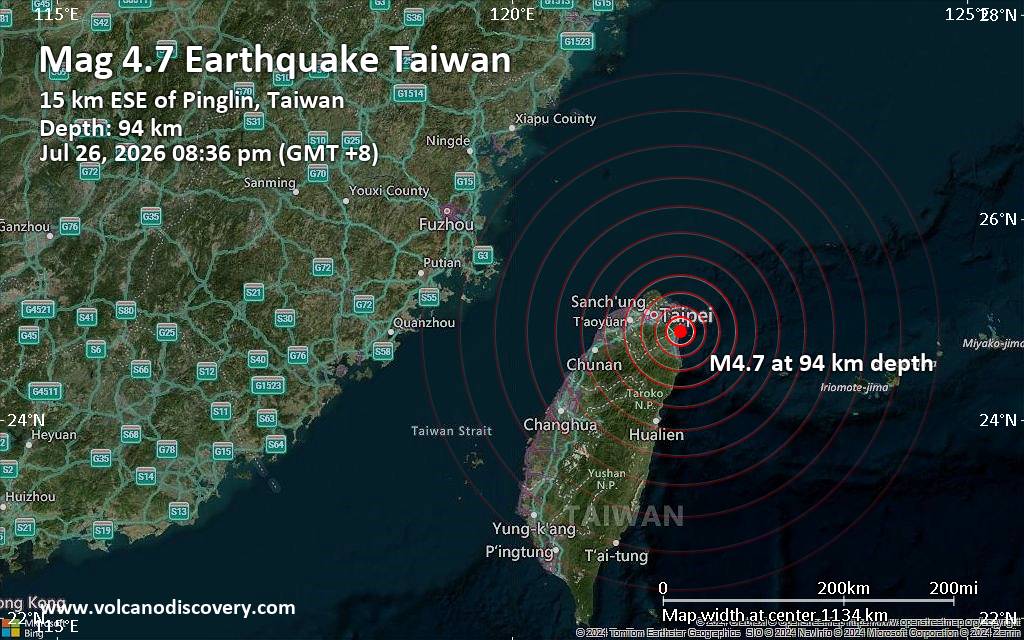 The United States Geological Survey reported a magnitude 4.7 quake in Taiwan near Taipei, Taipei City, Taiwan, only 21 minutes ago. The earthquake hit in the evening on Sunday, July 26th, 2026, at 8:36 pm local time at an intermediate depth of 93.84 km. The exact magnitude, epicenter, and depth of the quake might be revised within the next few hours or minutes as seismologists review data and refine their calculations, or as other agencies issue their report.
Our monitoring service identified a second report from the European-Mediterranean Seismological Centre (EMSC) which listed the quake at magnitude 4.7 as well. Other agencies reporting the same quake include Taiwan's Central Weather Bureau (CWB) at magnitude 5.6, the citizen-seismograph network of RaspberryShake at magnitude 5.1, and the German Research Centre for Geosciences (GFZ) at magnitude 5.1.
Weak shaking might have been felt in Pinglin (pop. 6,500) located 15 km from the epicenter, Yilan (pop. 94,200) 17 km away, Xizhi (pop. 204,600) 28 km away, Keelung (pop. 362,500) 29 km away, Neihu (pop. 274,500) 34 km away, Taipei (pop. 7,871,900) 38 km away, Banqiao (pop. 551,200) 41 km away, New Taipei City (pop. 4,004,400) 44 km away, Shulin (pop. 180,000) 45 km away, and Sanxia (pop. 115,200) 49 km away.
VolcanoDiscovery will automatically update magnitude and depth if these change and follow up if other significant news about the quake become available. If you’re in the area, please send us your experience through our reporting mechanism, either online or via our mobile app. This will help us provide more first-hand updates to anyone around the globe who wants to know more about this quake.
Earthquake data: Date & time: Jul 26, 2026 12:36 pm (Universal Time) local time (26 Jul 2026 12:36 GMT)Magnitude: 4.7 Depth: 93.84 km Epicenter latitude / longitude: 24.89°N / 121.85°E  (New Taipei City, Taipei, Taiwan) Primary data source: USGShttps://www.volcanodiscovery.com/earthquake/news/321072/Magnitude-47-earthquake-strikes-near-Taipei-Taipei-City-Taiwan.html
0
12
Read More
|
Significant 5.5 quake hits near Kupang, Kota Kupang, East Nusa Tenggara, Indonesia
Webmaster
Yesterday at 11:07 AM
Significant 5.5 quake hits near Kupang, Kota Kupang, East Nusa Tenggara, Indonesia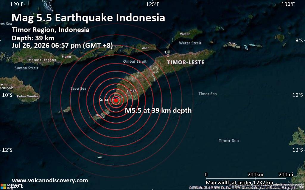 The European-Mediterranean Seismological Centre (EMSC) reported a magnitude 5.5 quake in Indonesia near Kupang, Kota Kupang, East Nusa Tenggara, only 8 minutes ago. The earthquake hit early evening on Sunday, July 26th, 2026, at 6:57 pm local time at a moderately shallow depth of 39. km. The exact magnitude, epicenter, and depth of the quake might be revised within the next few hours or minutes as seismologists review data and refine their calculations, or as other agencies issue their report.
A second report was later issued by the German Research Centre for Geosciences (GFZ), which listed it as a magnitude 5.5 earthquake as well.
Based on the preliminary seismic data, the quake was probably felt by many people in the area of the epicenter. It should not have caused significant damage, other than objects falling from shelves, broken windows, etc.
Moderate shaking probably occurred in Kupang (pop. 442,800) located 5 km from the epicenter.
Weak shaking might have been felt in Naisano Dua (pop. 2,300) located 68 km from the epicenter, Soe (pop. 40,200) 79 km away, and Kefamenanu (pop. 48,200) 123 km away.
VolcanoDiscovery will automatically update magnitude and depth if these change and follow up if other significant news about the quake become available. If you’re in the area, please send us your experience through our reporting mechanism, either online or via our mobile app. This will help us provide more first-hand updates to anyone around the globe who wants to know more about this quake.
Earthquake data: Date & time: Jul 26, 2026 06:57 pm (GMT +8) local time (26 Jul 2026 10:57 GMT)Magnitude: 5.5 Depth: 39.00 km Epicenter latitude / longitude: 10.2°S / 123.65°E  ( Kota Kupang, East Nusa Tenggara, Indonesia) Primary data source: EMSChttps://www.volcanodiscovery.com/earthquake/news/321067/Significant-55-quake-hits-near-Kupang-Kota-Kupang-East-Nusa-Tenggara-Indonesia.html
0
14
Read More
|
Significant earthquake of magnitude 5.8 just reported 66 miles southeast of Atka, Alaska, United States
Webmaster
Yesterday at 08:49 AM
Significant earthquake of magnitude 5.8 just reported 66 miles southeast of Atka, Alaska, United States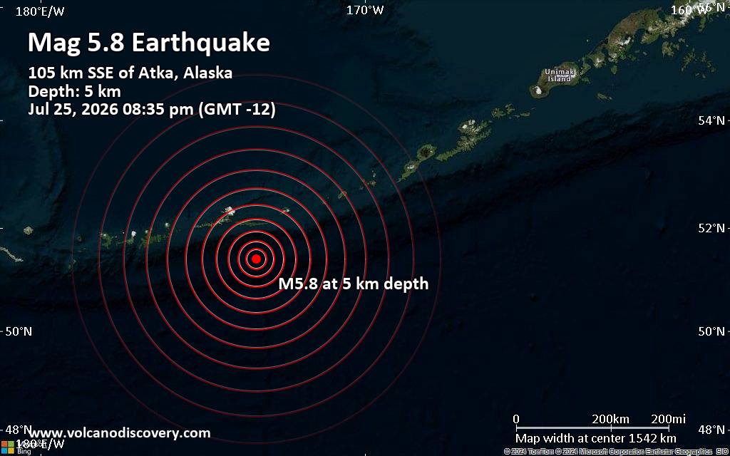 The United States was shaken near Atka, Aleutians West, Alaska, by an earthquake of magnitude 5.8 only 13 minutes ago, the United States Geological Survey reported.
The quake hit at a very shallow depth of 3.1 miles beneath the epicenter near Atka, Aleutians West, Alaska, USA, in the evening on Saturday, July 25th, 2026, at 8:35 pm local time. Shallow earthquakes are felt more strongly than deeper ones as they are closer to the surface. The exact magnitude, epicenter, and depth of the quake might be revised within the next few hours or minutes as seismologists review data and refine their calculations, or as other agencies issue their report.
Our monitoring service identified a second report from the German Research Centre for Geosciences (GFZ) which listed the quake at magnitude 5.6. A third agency, the European-Mediterranean Seismological Centre (EMSC), reported the same quake at magnitude 5.6.
Based on the preliminary seismic data, the quake was probably felt by many people in the area of the epicenter. It should not have caused significant damage, other than objects falling from shelves, broken windows, etc.
Weak shaking might have been felt in Atka (pop. 64) located 66 miles from the epicenter.
VolcanoDiscovery will automatically update magnitude and depth if these change and follow up if other significant news about the quake become available. If you’re in the area, please send us your experience through our reporting mechanism, either online or via our mobile app. This will help us provide more first-hand updates to anyone around the globe who wants to know more about this quake.
Earthquake data: Date & time: Jul 25, 2026 08:35 pm (GMT -12) local time (26 Jul 2026 08:35 GMT)Magnitude: 5.8 Depth: 5.00 km Epicenter latitude / longitude: 51.41°N / 173.35°W  ( Aleutians West Census Area, Alaska, United States) Primary data source: USGShttps://www.volcanodiscovery.com/earthquake/news/321063/Significant-earthquake-of-magnitude-58-just-reported-66-miles-southeast-of-Atka-Alaska-United-States.html
0
11
Read More
|
Eastern North Pacific Tropical Weather Outlook
Webmaster
Yesterday at 05:13 AM
000 ABPZ20 KNHC 260513 TWOEP Tropical Weather Outlook NWS National Hurricane Center Miami FL 1100 PM PDT Sat Jul 25 2026 For the eastern and central North Pacific east of 180 longitude: Active Systems: The National Hurricane Center is issuing advisories on Hurricane Fausto, located well east of the Hawaiian Islands, and on Hurricane Genevieve, located well southwest of the southwestern coast of Mexico. Well Southwest of Hawaii (CP92): Showers and thunderstorms associated with a broad area of low pressure located well west-southwest of the Hawaiian Islands are becoming better organized. Environmental conditions appear conducive for gradual development of this system while it moves generally westward at about 10 mph toward the International Date Line, and a tropical depression is expected to form in the western Pacific basin during the next couple of days. * Formation chance through 48 hours...high...70 percent. * Formation chance through 7 days...high...90 percent. && Products issued by the U.S. Joint Typhoon Warning Center can be found at: www.metoc.navy.mil/jtwc/jtwc.html Official tropical cyclone forecast information issued by the Japan Meteorological Agency for the western Pacific basin can be found at: www.jma.go.jp/jma/jma-eng/jma-center/rsmc-hp-pub-eg/RSMC_HP.html $$ Forecaster Gibbs/Evans/Pierce Source: Eastern North Pacific Tropical Weather Outlook
0
34
Read More
|
Tuesday: Light Rain, Minimum Temperature: 16°C (60°F) Maximum Temperature: 26°C (79°F)
Webmaster
Yesterday at 05:00 AM
Maximum Temperature: 26°C (79°F), Minimum Temperature: 16°C (60°F), Wind Direction: south-westerly, Wind Speed: 8mph, Visibility: Moderate, Pressure: 1018mb, Humidity: 70%, UV Risk: 4, Pollution: Low, Sunrise: 05:17 BST, Sunset: 21:12 BST Source: Tuesday: Light Rain, Minimum Temperature: 16°C (60°F) Maximum Temperature: 26°C (79°F)
0
33
Read More
|
|
Forums60
Topics792,808
Posts827,590
Members2,960
| |
Most Online102,106
Jul 10th, 2026
|
|
|
|
|
Copyright 1996 - 2026 by David Cottle. Designed by David Bate Jr. All Rights Reserved.
By using this forum, the user agrees not to transfer any data or technical information received under this agreement to any other entity without the express approval of the AUS-CITY Forum Admins and/or authors of individual posts (Forum Admins and DoD/USSPACECOM for the analysis of satellite tracking data).
Two-line elements (TLE) and all other satellite data presented and distributed via this forum and AUS-CITY mailing lists are distributed with permission from DoD/USSTRATCOM.


|

|


 - Click image for larger picture.")


