|
|
|
0 members (),
2,864
guests, and
32
robots. |
|
Key:
Admin,
Global Mod,
Mod
|
|
S |
M |
T |
W |
T |
F |
S |
|
|
|
|
|
1
|
2
|
3
|
|
4
|
5
|
6
|
7
|
8
|
9
|
10
|
|
11
|
12
|
13
|
14
|
15
|
16
|
17
|
|
18
|
19
|
20
|
21
|
22
|
23
|
24
|
|
25
|
26
|
27
|
28
|
29
|
30
|
31
|
|
There are no members with birthdays on this day. |

#735350
Mon 09 Sep 2024 06:53:AM
|
Joined: Feb 2001
Posts: 381,904
Launch Director
|
OP

Launch Director
Joined: Feb 2001
Posts: 381,904 |
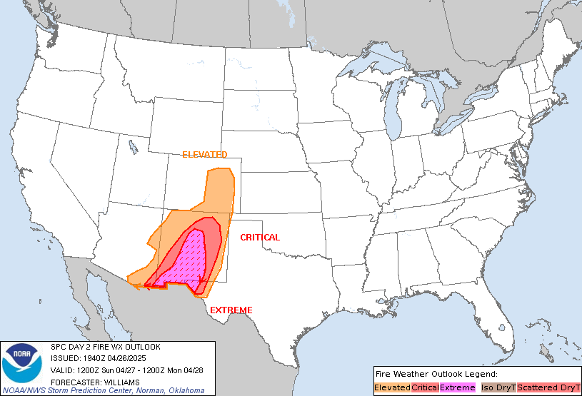
SPC Day 2 Fire Weather OutlookSPC Day 2 Fire Weather Outlook 
Day 2 Fire Weather Outlook
NWS Storm Prediction Center Norman OK
0151 AM CDT Mon Sep 09 2024

Valid 101200Z - 111200Z

...Synopsis...
Broad troughing over the Northwest is forecast to gradually
intensify Tuesday as a stronger shortwave and mid-level jet approach
from the eastern Pacific. Falling heights and increasing flow aloft
will move inland, supporting the potential for strong surface winds
and low humidity over parts of the Northwest and Great Basin.

..Great Basin...
Fire weather concerns will increase on Tuesday with the approach of
the strong trough/mid-level jet. Initially weak surface winds will
intensify over northwest and southern Nevada to 15-25 mph as flow
aloft increases. Several hours of elevated to locally critical
fire-weather conditions are likely as the stronger surface winds
develop with a dry air mass with RH values below 20%. Fuels are
driest across parts of the northern Great Basin and ID where
rainfall has been sparse. However, fuels farther south in NV and CA
remain sufficiently dry, and with stronger winds, elevated to near
critical conditions are likely.

...Cascades and Columbia Gorge...
Increasing mid-level winds will combine with a strong onshore
pressure gradient to drive 15-20 mph winds through the Gorge and the
western Columbia Basin along with RH potentially near 15%. The
duration of breezy and somewhat dry conditions may be somewhat
limited, but elevated to briefly critical fire weather may occur on
Tuesday.

..Lyons.. 09/09/2024

...Please see www.spc.noaa.gov/fire for graphic product...
Read morehttps://www.spc.noaa.gov/products/fire_wx/fwdy2.html
|
|


CMS The Best Conveyancing solicitors conveyancing quotes throughout the UK
For any webhosting enquiries please email webmaster@aus-city.com
|
|
Entire Thread
|

 SPC Day 2 Fire Weather Outlook
|
Webmaster
|
Mon 09 Sep 2024 06:53:AM
|
|
Forums60
Topics757,669
Posts792,375
Members2,958
| |
Most Online17,963
Jan 15th, 2026
|
|
|
|
|
Copyright 1996 - 2026 by David Cottle. Designed by David Bate Jr. All Rights Reserved.
By using this forum, the user agrees not to transfer any data or technical information received under the agreement, to any other entity without the express approval of the AUS-CITY Forum Admins and/or authors of individual posts (Forum Admins and DoD/USSPACECOM for the analysis of satellite tracking data).
Two-line elements (TLE) and all other satellite data presented and distributed via this forum and e-mail lists of AUS-CITY are distributed with permission from DoD/USSTRATCOM.


Reprise Hosting


|

|