|
|
|
0 members (),
1,314
guests, and
18
robots. |
|
Key:
Admin,
Global Mod,
Mod
|
|
S |
M |
T |
W |
T |
F |
S |
|
|
|
|
|
|
|
1
|
|
2
|
3
|
4
|
5
|
6
|
7
|
8
|
|
9
|
10
|
11
|
12
|
13
|
14
|
15
|
|
16
|
17
|
18
|
19
|
20
|
21
|
22
|
|
23
|
24
|
25
|
26
|
27
|
28
|
29
|
|
30
|
31
|
|
|
|
|
|
|
There are no members with birthdays on this day. |
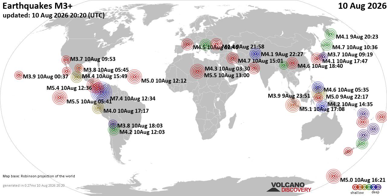
World Earthquake Report for Monday, 10 August 2026
• Volcano earthquake report for Monday, 10 Aug 2026
• Moderate mag. 4.0 earthquake - Zangilan Rayon, 58 km southwest of Ganja, Ga...
• Moderate mag. 4.6 earthquake - 31 km northeast of Xunchang, Sichuan, China,...
• Moderate mag. 4.2 earthquake - New Zealand on Tuesday, Aug 11, 2026, at 06:...
• World Earthquake Report for August 2026
|

#739791
Sun 29 Sep 2024 08:38:AM
|
Joined: Feb 2001
Posts: 678,976
Launch Director
|
OP

Launch Director
Joined: Feb 2001
Posts: 678,976 |
Issued at 500 AM AST Sun Sep 29 2024
000
WTNT31 KNHC 290838
TCPAT1

BULLETIN
Tropical Storm Joyce Advisory Number   8
NWS National Hurricane Center Miami FL       AL112024
500 AM AST Sun Sep 29 2024

...JOYCE LIKELY TO WEAKEN DURING THE NEXT COUPLE OF DAYS...


SUMMARY OF 500 AM AST...0900 UTC...INFORMATION
----------------------------------------------
LOCATION...21.3N 48.1W
ABOUT 1000 MI...1605 KM ENE OF THE NORTHERN LEEWARD ISLANDS
MAXIMUM SUSTAINED WINDS...45 MPH...75 KM/H
PRESENT MOVEMENT...NW OR 305 DEGREES AT 9 MPH...15 KM/H
MINIMUM CENTRAL PRESSURE...1004 MB...29.65 INCHES


WATCHES AND WARNINGS
--------------------
There are no coastal watches or warnings in effect.


DISCUSSION AND OUTLOOK
----------------------
At 500 AM AST (0900 UTC), the center of Tropical Storm Joyce was
located near latitude 21.3 North, longitude 48.1 West.  Joyce is
moving toward the northwest near 9 mph (15 km/h), and this general
motion with a decrease in forward speed is expected through tonight.
A turn toward the north and north-northeast is forecast on Monday
and Tuesday.

Maximum sustained winds remain near 45 mph (75 km/h) with higher
gusts.  Weakening is forecast, and Joyce is expected to become a
depression by early Monday and then a remnant low on Tuesday.

Tropical-storm-force winds extend outward up to 105 miles (165 km)
from the center.

The estimated minimum central pressure is 1004 mb (29.65 inches).


HAZARDS AFFECTING LAND
----------------------
None


NEXT ADVISORY
-------------
Next complete advisory at 1100 AM AST.

$$
Forecaster Pasch
Source: Tropical Storm Joyce Public Advisory Number 8
|
|



CMS The Best Conveyancing solicitors conveyancing quotes throughout the UK
For any webhosting enquiries please email webmaster@aus-city.com
|
|
Entire Thread
|
 Tropical Storm Joyce Public Advisory Number 8
|
Webmaster
|
Sun 29 Sep 2024 08:38:AM
|
|
Forums60
Topics796,363
Posts831,153
Members2,960
| |
Most Online102,106
Jul 10th, 2026
|
|
|
|
|

|





































