|
|
|
0 members (),
1,356
guests, and
28
robots. |
|
Key:
Admin,
Global Mod,
Mod
|
|
S |
M |
T |
W |
T |
F |
S |
|
|
|
|
|
1
|
2
|
3
|
|
4
|
5
|
6
|
7
|
8
|
9
|
10
|
|
11
|
12
|
13
|
14
|
15
|
16
|
17
|
|
18
|
19
|
20
|
21
|
22
|
23
|
24
|
|
25
|
26
|
27
|
28
|
29
|
30
|
31
|
|
There are no members with birthdays on this day. |
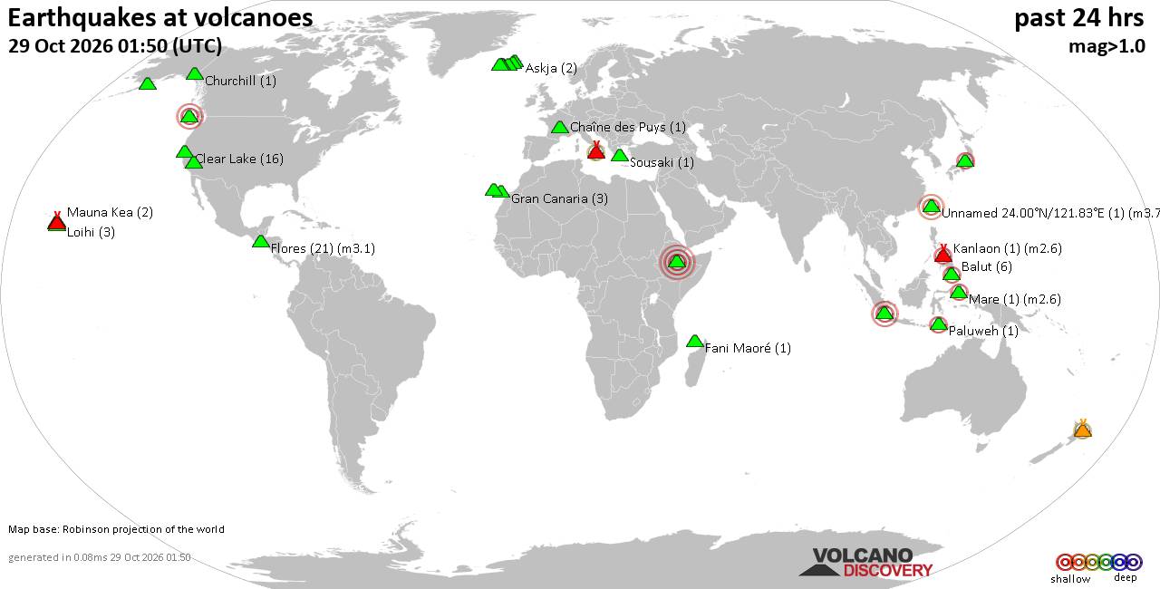
Volcano earthquake report for Thursday, 29 October 2026
• M 1.9 - 5 km WSW of Burning Man Earth, Nevada
• M 2.1 - 2 km E of Mountain Home, Arkansas
• M 2.5 - 95 km S of Sand Point, Alaska
• M 5.5 - 5 km ESE of Asahi, Japan
• M 5.0 - 43 km NNE of Semporna, Malaysia
|

#744465
Tue 12 Nov 2024 11:50:PM
|
Joined: Feb 2001
Posts: 678,977
Launch Director
|
|
Launch Director
Joined: Feb 2001
Posts: 678,977 |
Volcano earthquake report for Tuesday, 12 Nov 2024 World map showing volcanoes with shallow (less than 50 km) earthquakes within 20 km radius during the past 24 hours on 12 Nov 2024 Number in brackets indicate nr of quakes. Quakes detected near: Akyarlar (1 quake mag 1.2), Brennisteinsfjöll (2 quakes between mag 0.7-1.0), Clear Lake (12 quakes between mag 0.2-1.1), Egon (1 quake mag 3.0), Eldey (1 quake mag 2.0), Gran Canaria (1 quake mag 1.1)
Kilauea (3 quakes between mag 1.3-2.4), Loihi (1 quake mag 2.2), Loki-Fögrufjöll volcano (1 quake mag 1.9), Mammoth Mountain (1 quake mag 1.4), Mayon (1 quake mag 2.8), Nevado del Tolima (1 quake mag 1.6), Patoc (1 quake mag 2.2), Pocdol Mountains (3 quakes between mag 1.5-2.6), Reporoa (6 quakes between mag 1.5-2.0), Salton Buttes (1 quake mag 1.2), Sousaki (1 quake mag 1.1), Svartsengi (2 quakes between mag 0.8-1.6), Taupo (1 quake mag 1.7), Thordarhyrna (1 quake mag 1.5), Tjörnes Fracture Zone (11 quakes between mag 1.1-2.5), Tongariro (3 quakes between mag 0.4-1.2), Veniaminof (1 quake mag 1.4) (updated 23h50)
Note: Earthquakes within 20 km from and at depths less than 50 km under active volcanoes are reported. The list is not complete because many volcanoes are not monitored and/or seismic data in high resolution is not available publicly.
Volcanoes with recent earthquakes above magnitude 2 or more than 10 quakes are listed below:
Clear Lake volcano (California): 12 earthquakes up to magnitude 1.1Possible earthquake swarm: 12 earthquakes occurred near (under) the volcano during 13 hours, the last being recorded quake 8 hours ago. Hypocenter depths ranged between 4.3 and 0.2 km. Earthquake details: (only 5 largest) 1.1 quake 28 mi north of Santa Rosa, Sonoma County, California, United States, Nov 11, 2024 07:04 pm (Los Angeles time) (16 km SSW) 1.1 quake 8 km NNW of The Geysers, CA, Nov 12, 2024 07:32 am (Los Angeles time) (16 km SSW) 1.0 quake 1 km NW of Cobb, CA, Nov 12, 2024 07:13 am (Los Angeles time) (16 km SSE) 1.0 quake 9 km NNW of The Geysers, CA, Nov 11, 2024 07:58 pm (Los Angeles time) (16 km SSW) 0.9 quake 4 km WNW of Cobb, CA, Nov 12, 2024 12:36 am (Los Angeles time) (16 km S) All earthquakes at Clear LakeEgon volcano (Flores): magnitude 3.0 earthquakeA magnitude 3.0 earthquake occurred at the volcano 6 hours ago. The quake, which might be volcanic in origin, was located at a depth of 10.0 km depth at 8 km distance NNE from the volcano. Earthquake details: Reported seismic-like event (likely no quake): 30 km east of Maumere, East Nusa Tenggara, Indonesia, Nov 13, 2024 01:57 am (GMT +8) (8 km NNE) All earthquakes at EgonKilauea volcano (Hawai'i (Big Island)): 3 earthquakes up to magnitude 2.43 earthquakes occurred near (under) the volcano during 16 hours, the last being recorded quake 1 hour 48 minutes ago. Hypocenter depths ranged between 29.7 and 2.9 km. Earthquake details: 2.4 quake 37 mi southwest of Hilo, Hawaii County, Hawaii, United States, Nov 12, 2024 05:29 am (Honolulu time) (19 km SW) 1.9 quake 29 mi south of Hilo, Hawaii County, Hawaii, United States, Nov 12, 2024 12:01 pm (Honolulu time) (14 km SE) 1.3 quake 35 mi southwest of Hilo, Hawaii County, Hawaii, United States, Nov 11, 2024 08:12 pm (Honolulu time) (16 km SSW) All earthquakes at KilaueaLoihi volcano (Hawai'i (Big Island)): magnitude 2.2 earthquakeA magnitude 2.2 earthquake occurred at the volcano 16 hours ago. The quake, which might be volcanic in origin, was located at a depth of 32.8 km depth at 17 km distance NW from the volcano. Earthquake details: 2.2 quake North Pacific Ocean, 13 mi southeast of Pāhala, Hawaii County, Hawaii, United States, Nov 11, 2024 10:03 pm (GMT -10) (17 km NW) All earthquakes at LoihiMayon volcano (Luzon Island): magnitude 2.8 earthquakeA magnitude 2.8 earthquake occurred at the volcano 1 hour 25 minutes ago. The quake, which might be volcanic in origin, was located at a depth of 12.0 km depth at 14 km distance E from the volcano. Earthquake details: 2.8 quake 13 km northeast of Legazpi, Albay, Bicol, Philippines, Nov 13, 2024 06:25 am (Manila time) (14 km E) All earthquakes at MayonPatoc volcano (Luzon Island): magnitude 2.2 earthquakeA magnitude 2.2 earthquake occurred at the volcano 12 hours ago. The quake, which might be volcanic in origin, was located at a depth of 31.0 km depth at 11 km distance SW from the volcano. Earthquake details: 2.2 quake Mountain, 27 km northeast of Mankayan, Benguet, Cordillera, Philippines, Nov 12, 2024 07:41 pm (Manila time) (11 km SW) All earthquakes at PatocPocdol Mountains volcano (Luzon Island): 3 earthquakes up to magnitude 2.63 earthquakes occurred near (under) the volcano during 5 hours, the last being recorded quake 8 hours ago. Hypocenter depths ranged between 34.0 and 1.0 km. Earthquake details: 2.6 quake 10.1 km northwest of Sorsogon, Sorsogon, Bicol, Philippines, Nov 12, 2024 06:59 pm (Manila time) (5 km WSW) 1.9 quake Sorsogon, 18 km southeast of Legazpi, Albay, Bicol, Philippines, Nov 12, 2024 07:24 pm (Manila time) (15 km WSW) 1.5 quake 10.9 km northwest of Sorsogon, Sorsogon, Bicol, Philippines, Nov 13, 2024 12:12 am (Manila time) (3 km W) All earthquakes at Pocdol MountainsTjörnes Fracture Zone volcano (Iceland): 11 earthquakes up to magnitude 2.5Possible earthquake swarm: 11 earthquakes occurred near (under) the volcano during 8 hours, the last being recorded quake 14 hours ago. Hypocenter depths ranged between 21.6 and 4.6 km. Earthquake details: (only 5 largest) 2.5 quake 33.8 km ESE of Grímsey Nov 12, 2024 09:11 am (Reykjavik time) (17 km NW) 1.5 quake 34.5 km ESE of Grímsey Nov 12, 2024 09:27 am (Reykjavik time) (17 km NNW) 1.3 quake 11.4 km WSW of Kópasker Nov 12, 2024 09:31 am (Reykjavik time) (19 km ESE) 1.3 quake 34.0 km ESE of Grímsey Nov 12, 2024 09:15 am (Reykjavik time) (17 km NNW) 1.3 quake 34.8 km ESE of Grímsey Nov 12, 2024 08:50 am (Reykjavik time) (16 km NNW) All earthquakes at Tjörnes Fracture Zonehttps://www.volcanodiscovery.com/earthquakes-volcanoes/news/257617/Volcano-earthquake-report-for-Tuesday-12-Nov-2024.html
|
|



CMS The Best Conveyancing solicitors conveyancing quotes throughout the UK
For any webhosting enquiries please email webmaster@aus-city.com
|
|
Entire Thread
|
 Volcano earthquake report for Tuesday, 12 Nov 2024 |
Webmaster
|
Tue 12 Nov 2024 11:50:PM
|
|
Forums60
Topics900,683
Posts935,480
Members2,960
| |
Most Online102,106
Jul 10th, 2026
|
|
|
|
|

|









































