|
|
|
2 members (Webmaster, Alisa),
3,023
guests, and
31
robots. |
|
Key:
Admin,
Global Mod,
Mod
|
|
S |
M |
T |
W |
T |
F |
S |
|
|
|
|
|
|
1
|
2
|
|
3
|
4
|
5
|
6
|
7
|
8
|
9
|
|
10
|
11
|
12
|
13
|
14
|
15
|
16
|
|
17
|
18
|
19
|
20
|
21
|
22
|
23
|
|
24
|
25
|
26
|
27
|
28
|
29
|
30
|
|
31
|
|
|
|
|
|
|
|
There are no members with birthdays on this day. |

World Earthquake Report for Tuesday, 19 May 2026
• Volcano earthquake report for Tuesday, 19 May 2026
• Magnitude 5.2 earthquake strikes near Kahoku, Kahoku Shi, Ishikawa-ken, Jap...
• Moderate mag. 4.7 earthquake - Southern Iran on Tuesday, May 19, 2026, at 1...
• Strong mag. 5.2 earthquake - Sea of Japan or East Sea, 98 km northwest of K...
• Moderate mag. 4.5 earthquake - 25 km northwest of Takayama, Gifu, Japan, on...
|

#757097
Sun 09 Mar 2025 10:01:PM
|
Joined: Feb 2001
Posts: 381,904
Launch Director
|
OP

Launch Director
Joined: Feb 2001
Posts: 381,904 |
Magnitude 2.8 earthquake strikes near Helena, Lewis and Clark County, Montana, USA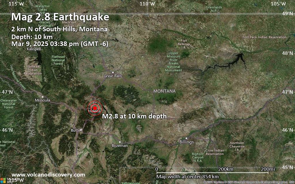 A magnitude 2.8 earthquake near Helena, Lewis and Clark County, Montana, USA, was reported only 22 minutes ago by the United States Geological Survey, considered the key international and national agency that monitors seismic activity in the US. The earthquake occurred at a shallow depth of 6.2 miles beneath the epicenter early afternoon on Sunday, March 9th, 2025, at 3:38 pm local time. The exact magnitude, epicenter, and depth of the quake might be revised within the next few hours or minutes as seismologists review data and refine their calculations, or as other agencies issue their report.
Our monitoring service identified a second report from the European-Mediterranean Seismological Centre (EMSC) which listed the quake at magnitude 2.8 as well.
Towns or cities near the epicenter where the quake might have been felt as very weak shaking include South Hills (pop. 520) located 1 miles from the epicenter, Helena (pop. 30,600) 2 miles away, East Helena (pop. 2,100) 4 miles away, Montana City (pop. 2,700) 4 miles away, Helena Valley Southeast (pop. 8,200) 5 miles away, Helena Valley Southeast (pop. 8,200) 5 miles away, Helena Valley West Central (pop. 7,900) 7 miles away, and Helena Valley Northeast (pop. 3,000) 9 miles away.
Earthquake data: Date & time: Mar 9, 2025 09:38 pm (Universal Time) local time (9 Mar 2025 21:38 GMT)Magnitude: 2.8 Depth: 10.00 km Epicenter latitude / longitude: 46.58°N / 112°W  ( Lewis and Clark, Montana, United States) Primary data source: USGShttps://www.volcanodiscovery.com/earthquake/news/266704/Magnitude-28-earthquake-strikes-near-Helena-Lewis-and-Clark-County-Montana-USA.html
|
|


CMS The Best Conveyancing solicitors conveyancing quotes throughout the UK
For any webhosting enquiries please email webmaster@aus-city.com
|
|
Entire Thread
|
 Magnitude 2.8 earthquake strikes near Helena, Lewis and Clark County, Montana, USA
|
Webmaster
|
Sun 09 Mar 2025 10:01:PM
|
|
Forums60
Topics775,579
Posts810,371
Members2,960
| |
Most Online22,463
May 9th, 2026
|
|
|
|
|
Copyright 1996 - 2026 by David Cottle. Designed by David Bate Jr. All Rights Reserved.
By using this forum, the user agrees not to transfer any data or technical information received under this agreement to any other entity without the express approval of the AUS-CITY Forum Admins and/or authors of individual posts (Forum Admins and DoD/USSPACECOM for the analysis of satellite tracking data).
Two-line elements (TLE) and all other satellite data presented and distributed via this forum and AUS-CITY mailing lists are distributed with permission from DoD/USSTRATCOM.

|

|


 - Click image for larger picture.")


