|
|
|
0 members (),
331
guests, and
22
robots. |
|
Key:
Admin,
Global Mod,
Mod
|
|
S |
M |
T |
W |
T |
F |
S |
|
|
|
1
|
2
|
3
|
4
|
5
|
|
6
|
7
|
8
|
9
|
10
|
11
|
12
|
|
13
|
14
|
15
|
16
|
17
|
18
|
19
|
|
20
|
21
|
22
|
23
|
24
|
25
|
26
|
|
27
|
28
|
29
|
30
|
31
|
|
|
|
There are no members with birthdays on this day. |
|
|
|
|
|
|
|
|
|
|
big couch
by Webmaster - Sat 05 Jul 2025 06:00:AM
|
|
|
|
|
|
|
|
|

#764596
Sun 08 Jun 2025 11:50:PM
|
Joined: Feb 2001
Posts: 381,904
Launch Director
|
OP

Launch Director
Joined: Feb 2001
Posts: 381,904 |
Volcano earthquake report for Sunday, 8 Jun 2025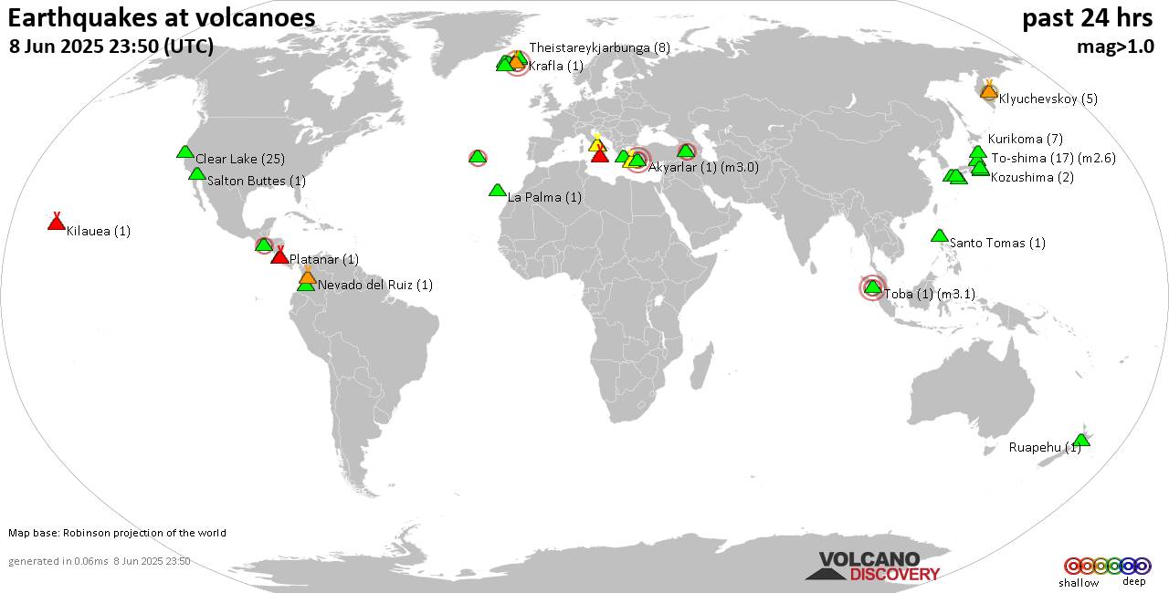 World map showing volcanoes with shallow (less than 50 km) earthquakes within 20 km radius during the past 24 hours on 8 Jun 2025 Number in brackets indicate nr of quakes. Quakes detected near: Akyarlar (1 quake mag 3.0), Apaneca Range (1 quake mag 2.1), Bardarbunga (3 quakes between mag 0.4-3.1), Brennisteinsfjöll (13 quakes between mag 0.0-1.8), Campi Flegrei (Phlegrean Fields) (34 quakes between mag 0.1-2.1), Clear Lake (25 quakes between mag 0.2-1.3)
Etna (1 quake mag 1.4), Fukue (2 quakes between mag 0.7-1.2), Furnas (5 quakes between mag 2.0-3.0), Hiuchi (7 quakes between mag 0.1-1.8), Hrómundartindur (3 quakes between mag 0.2-1.0), Izu-Tobu (2 quakes between mag 0.2-1.0), Kilauea (1 quake mag 1.5), Kirishima (11 quakes between mag 0.1-1.1), Klyuchevskoy (5 quakes between mag 0.9-2.0), Kolumbo (4 quakes between mag 0.9-1.4), Kozushima (2 quakes between mag 1.3-1.4), Krafla (1 quake mag 1.2), Kurikoma (7 quakes between mag 0.1-1.0), La Palma (1 quake mag 1.2), Ljósufjöll (4 quakes between mag 0.9-1.4), Nevado del Huila (1 quake mag 1.8), Nevado del Ruiz (1 quake mag 1.2), Platanar (1 quake mag 1.2), Poas (1 quake mag 1.1), Prestahnukur (9 quakes between mag 0.8-1.7), Ruapehu (1 quake mag 1.0), Salton Buttes (1 quake mag 1.0), Santo Tomas (1 quake mag 1.8), Santorini (1 quake mag 1.9), Sousaki (1 quake mag 1.9), Tendürek Dağ (1 quake mag 2.5), Theistareykjarbunga (8 quakes between mag 0.8-2.3), Tjörnes Fracture Zone (2 quakes between mag 0.7-1.5), To-shima (17 quakes between mag 0.5-2.6), Toba (1 quake mag 3.1), Unzen (1 quake mag 1.6), Vesuvius (1 quake mag 1.6) (updated 23h50)
Note: Earthquakes within 20 km from and at depths less than 50 km under active volcanoes are reported. The list is not complete because many volcanoes are not monitored and/or seismic data in high resolution is not available publicly.
Volcanoes with recent earthquakes above magnitude 2 or more than 10 quakes are listed below:
Akyarlar volcano (Turkey): magnitude 3.0 earthquakeA magnitude 3.0 earthquake occurred at the volcano 3 hours ago. The quake, which might be volcanic in origin, was located at a depth of 10.00 km depth at 5 km distance WNW from the volcano. Earthquake details: Reported seismic-like event (likely no quake): 13 km north of Kos, Dodecanese, South Aegean, Greece, Jun 9, 2025 12:02 am (GMT +3) (5 km WNW) All earthquakes at AkyarlarApaneca Range volcano (El Salvador): magnitude 2.1 earthquakeA magnitude 2.1 earthquake occurred at the volcano 8 hours ago. The quake, which might be volcanic in origin, was located at a depth of 5.00 km depth at 4 km distance E from the volcano. Earthquake details: 2.1 quake 18 km north of Sonsonate, Departamento de Sonsonate, El Salvador, Jun 8, 2025 09:46 am (GMT -6) (4 km E) All earthquakes at Apaneca RangeBardarbunga volcano (Iceland): 3 earthquakes up to magnitude 3.13 earthquakes occurred near (under) the volcano during 19 hours, the last being recorded quake 3 hours ago. Hypocenter depths ranged between 1.80 and 1.10 km. Earthquake details: 3.1 quake 117 km south of Akureyri, Northeast, Iceland, Jun 8, 2025 01:58 am (Reykjavik time) (5 km NE) 0.5 quake 5.8 km E of Bárðarbunga Jun 8, 2025 12:45 pm (Universal Time) (6 km E) 0.4 quake Iceland: 6.3 km E of Bárðarbunga Jun 8, 2025 09:02 pm (Reykjavik time) (7 km E) All earthquakes at BardarbungaBrennisteinsfjöll volcano (Reykjanes Peninsula, Iceland): 13 earthquakes up to magnitude 1.8Possible earthquake swarm: 13 earthquakes occurred near (under) the volcano during 6 hours, the last being recorded quake 18 hours ago. Hypocenter depths ranged between 9.20 and 4.00 km. Earthquake details: (only 5 largest) 1.8 quake 3.6 km W of Raufarhólshellir Jun 8, 2025 12:08 am (Universal Time) (18 km E) 0.6 quake 2.8 km W of Raufarhólshellir Jun 8, 2025 12:10 am (Universal Time) (19 km E) 0.5 quake Iceland: 5.9 km SSE of Helgafell Jun 8, 2025 05:34 am (Reykjavik time) (4 km NNE) 0.4 quake Iceland: 6.6 km S of Helgafell Jun 8, 2025 05:58 am (Reykjavik time) (3 km N) 0.4 quake 2.6 km W of Raufarhólshellir Jun 8, 2025 12:19 am (Universal Time) (19 km E) All earthquakes at BrennisteinsfjöllCampi Flegrei (Phlegrean Fields) volcano (Italy): 34 earthquakes up to magnitude 2.1Possible earthquake swarm: 34 earthquakes occurred near (under) the volcano during 23 hours, the last being recorded quake 31 minutes ago. Hypocenter depths ranged between 2.68 and 0.02 km. Earthquake details: (only 5 largest) 2.1 quake 4.6 km southeast of Pozzuoli, Napoli, Campania, Italy, Jun 8, 2025 07:14 am (GMT +2) (0 km SE) 1.6 quake 2.5 km southeast of Pozzuoli, Napoli, Campania, Italy, Jun 9, 2025 01:19 am (GMT +2) (2 km W) 1.3 quake Tyrrhenian Sea, 22 km northeast of Isola d'Ischia Island, Italy, Jun 8, 2025 07:03 am (GMT +2) (1 km SSE) 1.2 quake 4.5 km west of Fuorigrotta, Napoli, Campania, Italy, Jun 8, 2025 07:03 am (GMT +2) (1 km SE) 1.0 quake 4.8 km southeast of Pozzuoli, Napoli, Campania, Italy, Jun 8, 2025 07:33 am (GMT +2) (1 km SE) All earthquakes at Campi Flegrei (Phlegrean Fields)Clear Lake volcano (California): 25 earthquakes up to magnitude 1.3Possible earthquake swarm: 25 earthquakes occurred near (under) the volcano during 21 hours, the last being recorded quake 27 minutes ago. Hypocenter depths ranged between 3.31 and 0.19 km. Earthquake details: (only 5 largest) 1.3 quake 27 mi north of Santa Rosa, Sonoma County, California, United States, Jun 8, 2025 11:45 am (GMT -7) (17 km SSW) 1.2 quake 27 mi north of Santa Rosa, Sonoma County, California, United States, Jun 8, 2025 02:52 am (GMT -7) (17 km S) 1.1 quake 28 mi north of Santa Rosa, Sonoma County, California, United States, Jun 7, 2025 07:55 pm (GMT -7) (15 km S) 1.1 quake Lake County, 28 mi north of Santa Rosa, Sonoma County, California, United States, Jun 8, 2025 02:41 am (GMT -7) (15 km S) 1.1 quake 28 mi north of Santa Rosa, Sonoma County, California, United States, Jun 8, 2025 10:02 am (GMT -7) (16 km SSW) All earthquakes at Clear LakeFurnas volcano (Azores): 5 earthquakes up to magnitude 3.05 earthquakes occurred near (under) the volcano during 14 hours, the last being recorded quake 3 hours ago. Hypocenter depths ranged between 2.00 and 1.00 km. Earthquake details: 3.0 quake North Atlantic Ocean, 29 km southeast of Ilha de Sao Miguel Island, Portugal, Jun 8, 2025 07:15 am (Universal Time) (18 km SSE) 2.8 quake North Atlantic Ocean, 28 km southeast of Ilha de Sao Miguel Island, Portugal, Jun 8, 2025 03:57 pm (Universal Time) (17 km SSE) 2.4 quake North Atlantic Ocean, 28 km southeast of Ilha de Sao Miguel Island, Portugal, Jun 8, 2025 08:48 pm (Universal Time) (18 km SSE) 2.4 quake North Atlantic Ocean, 29 km southeast of Ilha de Sao Miguel Island, Portugal, Jun 8, 2025 10:00 am (Universal Time) (18 km SSE) 2.0 quake North Atlantic Ocean, 28 km southeast of Ilha de Sao Miguel Island, Portugal, Jun 8, 2025 06:32 pm (Universal Time) (18 km SSE) All earthquakes at FurnasKirishima volcano (Kyushu): 11 earthquakes up to magnitude 1.1Possible earthquake swarm: 11 earthquakes occurred near (under) the volcano during 22 hours, the last being recorded quake 1 hour 36 minutes ago. Hypocenter depths ranged between 9.40 and 5.60 km. Earthquake details: (only 5 largest) 1.1 quake 4.9 km southwest of Kobayashi, Miyazaki, Japan, Jun 9, 2025 12:02 am (GMT +9) (8 km ENE) 0.9 quake 5.3 km southwest of Kobayashi, Miyazaki, Japan, Jun 9, 2025 03:54 am (GMT +9) (7 km ENE) 0.9 quake 5.7 km southwest of Kobayashi, Miyazaki, Japan, Jun 8, 2025 12:14 pm (GMT +9) (7 km ENE) 0.9 quake 5.4 km southwest of Kobayashi, Miyazaki, Japan, Jun 8, 2025 09:30 am (GMT +9) (7 km ENE) 0.5 quake 5.7 km southwest of Kobayashi, Miyazaki, Japan, Jun 9, 2025 07:14 am (GMT +9) (7 km ENE) All earthquakes at KirishimaTendürek Dağ volcano (Turkey): magnitude 2.5 earthquakeA magnitude 2.5 earthquake occurred at the volcano 3 hours ago. The quake, which might be volcanic in origin, was located at a depth of 3.60 km depth at 18 km distance ENE from the volcano. Earthquake details: 2.5 quake 15 km south of Dogubayazit, Agri, Turkey, Jun 9, 2025 12:25 am (GMT +3:30) (18 km ENE) All earthquakes at Tendürek DağTheistareykjarbunga volcano (Iceland): 8 earthquakes up to magnitude 2.38 earthquakes occurred near (under) the volcano during 20 hours, the last being recorded quake 30 minutes ago. Hypocenter depths ranged between 14.50 and 5.20 km. Earthquake details: (only 5 largest) 2.3 quake 0.7 km WSW of Þeistareykir Jun 8, 2025 03:34 am (Universal Time) (6 km W) 1.9 quake 0.5 km SSW of Þeistareykir Jun 8, 2025 03:39 am (Universal Time) (6 km W) 1.3 quake Iceland: 13.8 km E of Húsavík Jun 8, 2025 11:46 am (Reykjavik time) (18 km NNW) 1.0 quake Iceland: 0.5 km SW of Þeistareykir Jun 8, 2025 11:20 pm (Reykjavik time) (6 km W) 1.0 quake Iceland: 0.8 km SW of Þeistareykir Jun 8, 2025 03:33 am (Reykjavik time) (6 km WSW) All earthquakes at TheistareykjarbungaTo-shima volcano (Izu Islands): 17 earthquakes up to magnitude 2.6Possible earthquake swarm: 17 earthquakes occurred near (under) the volcano during 19 hours, the last being recorded quake 3 hours ago. Hypocenter depths ranged between 18.20 and 8.60 km. Earthquake details: (only 5 largest) 2.6 quake North Pacific Ocean, Tokyo, 46 km east of Shimoda, Shizuoka, Japan, Jun 9, 2025 03:11 am (GMT +9) (14 km ENE) 2.6 quake North Pacific Ocean, 31 km southeast of Shimoda, Shizuoka, Japan, Jun 9, 2025 05:28 am (GMT +9) (6 km W) 1.5 quake North Pacific Ocean, Tokyo, 45 km east of Shimoda, Shizuoka, Japan, Jun 9, 2025 03:14 am (GMT +9) (13 km ENE) 1.5 quake Philippine Sea, 29 km north of Kozu Shima Island, Tokyo, Japan, Jun 9, 2025 02:01 am (GMT +9) (7 km SSW) 1.3 quake Japan: Near Izu-Oshima Island Jun 9, 2025 04:33 am (GMT +9) (13 km ENE) All earthquakes at To-shimaToba volcano (Sumatra): magnitude 3.1 earthquakeA magnitude 3.1 earthquake occurred at the volcano 18 hours ago. The quake, which might be volcanic in origin, was located at a depth of 5.00 km depth at 18 km distance WNW from the volcano. Earthquake details: 3.1 quake Kabupaten Humbang Hasundutan, 51 km northwest of Tarutung, Indonesia, Jun 8, 2025 12:27 pm (GMT +7) (18 km WNW) All earthquakes at Tobahttps://www.volcanodiscovery.com/earthquakes-volcanoes/news/273077/Volcano-earthquake-report-for-Sunday-8-Jun-2025.html
|
|


CMS The Best Conveyancing solicitors conveyancing quotes throughout the UK
For any webhosting enquiries please email webmaster@aus-city.com
|
|
Entire Thread
|
 Volcano earthquake report for Sunday, 8 Jun 2025
|
Webmaster
|
Sun 08 Jun 2025 11:50:PM
|
|
Forums60
Topics730,450
Posts765,066
Members2,958
| |
Most Online4,158
Jun 21st, 2024
|
|
|
|
|
Copyright 1996 - 2024 by David Cottle. Designed by David Bate Jr. All Rights Reserved.
By using this forum, the user agrees not to transfer any data or technical information received under the agreement, to any other entity without the express approval of the AUS-CITY Forum Admins and/or authors of individual posts (Forum Admins and DoD/USSPACECOM for the analysis of satellite tracking data).
Two-line elements (TLE) and all other satellite data presented and distributed via this forum and e-mail lists of AUS-CITY are distributed with permission from DoD/USSTRATCOM.

Reprise Hosting

|

|


 - Click image for larger picture.")


