|
|
|
0 members (),
4,988
guests, and
25
robots. |
|
Key:
Admin,
Global Mod,
Mod
|
|
S |
M |
T |
W |
T |
F |
S |
|
1
|
2
|
3
|
4
|
5
|
6
|
7
|
|
8
|
9
|
10
|
11
|
12
|
13
|
14
|
|
15
|
16
|
17
|
18
|
19
|
20
|
21
|
|
22
|
23
|
24
|
25
|
26
|
27
|
28
|
|
29
|
30
|
31
|
|
|
|
|
|
There are no members with birthdays on this day. |

#768127
Thu 17 Jul 2025 11:50:AM
|
Joined: Feb 2001
Posts: 381,904
Launch Director
|
OP

Launch Director
Joined: Feb 2001
Posts: 381,904 |
Volcano earthquake report for Thursday, 17 Jul 2025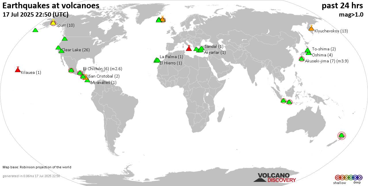 World map showing volcanoes with shallow (less than 50 km) earthquakes within 20 km radius during the past 24 hours on 17 Jul 2025 Number in brackets indicate nr of quakes. Quakes detected near: Akan (1 quake mag 1.1), Akuseki-jima (12 quakes between mag 1.5-3.3), Askja (1 quake mag 1.4), Auckland Field (1 quake mag 3.0), Bardarbunga (6 quakes between mag 0.4-3.0), Brennisteinsfjöll (5 quakes between mag 0.1-1.0)
Cerro Singüil (1 quake mag 2.4), Clear Lake (19 quakes between mag 0.1-1.2), Coso (1 quake mag 1.1), El Chichón (3 quakes between mag 2.3-2.7), El Hierro (1 quake mag 1.7), Eldey (1 quake mag 1.9), Hiuchi (10 quakes between mag 0.2-1.1), Hrómundartindur (9 quakes between mag 0.1-1.9), Izu-Tobu (5 quakes between mag 0.1-1.0), Kilauea (3 quakes between mag 1.7-2.5), Klyuchevskoy (11 quakes between mag 1.0-1.5), Kolumbo (4 quakes between mag 1.0-3.0), Krísuvík (12 quakes between mag 0.1-1.8), La Palma (1 quake mag 1.6), Ljósufjöll (8 quakes between mag 0.5-1.6), Michoacán-Guanajuato (6 quakes between mag 2.2-2.9), Miravalles (1 quake mag 1.4), Mount Rainier (24 quakes between mag 0.1-1.8), Oshima (2 quakes between mag 0.6-1.4), Reporoa (2 quakes between mag 1.5-2.2), Salton Buttes (1 quake mag 1.1), Spurr (9 quakes between mag 0.0-1.5), Suwanose-jima (1 quake mag 1.5), Tenerife (2 quakes between mag 1.0-1.5), To-shima (2 quakes between mag 1.2-1.4), Ushkovsky (1 quake mag 2.5) (updated 11h50)
Note: Earthquakes within 20 km from and at depths less than 50 km under active volcanoes are reported. The list is not complete because many volcanoes are not monitored and/or seismic data in high resolution is not available publicly.
Volcanoes with recent earthquakes above magnitude 2 or more than 10 quakes are listed below:
Akuseki-jima volcano (Ryukyu Islands): 12 earthquakes up to magnitude 3.3Possible earthquake swarm: 12 earthquakes occurred near (under) the volcano during 21 hours, the last being recorded quake 2 hours ago. Hypocenter depths ranged between 24.00 and 8.30 km. Earthquake details: (only 5 largest) 3.3 quake East China Sea, Kagoshima-ken, 39 km southwest of Suwanose-jima Island, Japan, Jul 17, 2025 12:05 pm (GMT +9) (17 km SW) 3.3 quake East China Sea, Kagoshima-ken, 41 km southwest of Suwanose-jima Island, Japan, Jul 16, 2025 09:32 pm (GMT +9) (19 km SSW) 2.7 quake East China Sea, Kagoshima-ken, 41 km southwest of Suwanose-jima Island, Japan, Jul 17, 2025 11:55 am (GMT +9) (19 km SSW) 2.7 quake East China Sea, Kagoshima-ken, 38 km southwest of Suwanose-jima Island, Japan, Jul 16, 2025 10:40 pm (GMT +9) (16 km SSW) 2.6 quake East China Sea, Kagoshima-ken, 38 km southwest of Suwanose-jima Island, Japan, Jul 17, 2025 08:26 am (GMT +9) (12 km SW) All earthquakes at Akuseki-jimaAuckland Field volcano (North Island): magnitude 3.0 earthquakeA magnitude 3.0 earthquake occurred at the volcano 13 hours ago. The quake, which might be volcanic in origin, was located at a depth of 10.00 km depth at 17 km distance SSE from the volcano. Earthquake details: Reported seismic-like event (likely no quake): 27 km southeast of Auckland, Auckland, New Zealand, Jul 17, 2025 11:13 am (GMT +12) (17 km SSE) All earthquakes at Auckland FieldBardarbunga volcano (Iceland): 6 earthquakes up to magnitude 3.06 earthquakes occurred near (under) the volcano during 8 hours, the last being recorded quake 15 hours ago. Hypocenter depths ranged between 2.90 and 1.10 km. Earthquake details: (only 5 largest) 3.0 quake 117 km south of Akureyri, Northeast, Iceland, Jul 16, 2025 02:07 pm (Reykjavik time) (4 km NNE) 2.8 quake Northeast, 222 km east of Reykjavik, Capital Region, Iceland, Jul 16, 2025 12:44 pm (Universal Time) (6 km NE) 2.5 quake 3.8 km NNE of Bárðarbunga Jul 16, 2025 08:50 pm (Universal Time) (5 km NNE) 1.4 quake 5.9 km NE of Bárðarbunga Jul 16, 2025 01:03 pm (Universal Time) (7 km NE) 1.2 quake 3.8 km N of Bárðarbunga Jul 16, 2025 02:09 pm (Universal Time) (5 km N) All earthquakes at BardarbungaCerro Singüil volcano (El Salvador): magnitude 2.4 earthquakeA magnitude 2.4 earthquake occurred at the volcano 4 hours ago. The quake, which might be volcanic in origin, was located at a depth of 8.00 km depth at 9 km distance NW from the volcano. Earthquake details: 2.4 quake 20 km northwest of Santa Ana, Departamento de Santa Ana, El Salvador, Jul 17, 2025 01:28 am (GMT -6) (9 km NW) All earthquakes at Cerro SingüilClear Lake volcano (California): 19 earthquakes up to magnitude 1.2Possible earthquake swarm: 19 earthquakes occurred near (under) the volcano during 23 hours, the last being recorded quake 1 hour 11 minutes ago. Hypocenter depths ranged between 8.14 and 1.54 km. Earthquake details: (only 5 largest) 1.2 quake 26 mi north of Santa Rosa, Sonoma County, California, United States, Jul 16, 2025 10:57 pm (Universal Time) (18 km S) 1.2 quake 26 mi north of Santa Rosa, Sonoma County, California, United States, Jul 17, 2025 08:43 am (Universal Time) (18 km SSW) 1.0 quake 25 mi north of Santa Rosa, Sonoma County, California, United States, Jul 17, 2025 06:51 am (Universal Time) (19 km S) 0.8 quake 27 mi north of Santa Rosa, Sonoma County, California, United States, Jul 17, 2025 09:21 am (Universal Time) (18 km SSW) 0.7 quake 27 mi north of Santa Rosa, Sonoma County, California, United States, Jul 17, 2025 10:39 am (Universal Time) (16 km S) All earthquakes at Clear LakeEl Chichón volcano (Southern Mexico): 3 earthquakes up to magnitude 2.73 earthquakes occurred near (under) the volcano during 40 minutes, the last being recorded quake 20 hours ago. Hypocenter depths ranged between 2.00 and 2.00 km. Earthquake details: 2.7 quake Estado de Chiapas, 36 km southwest of Teapa, Estado de Tabasco, Mexico, Jul 16, 2025 09:53 am (GMT -6) (7 km NNW) 2.5 quake Estado de Chiapas, 35 km southwest of Teapa, Estado de Tabasco, Mexico, Jul 16, 2025 09:13 am (GMT -6) (1 km E) 2.3 quake Estado de Chiapas, 36 km southwest of Teapa, Estado de Tabasco, Mexico, Jul 16, 2025 09:26 am (GMT -6) (0 km ENE) All earthquakes at El ChichónKilauea volcano (Hawai'i (Big Island)): 3 earthquakes up to magnitude 2.53 earthquakes occurred near (under) the volcano during 11 hours, the last being recorded quake 12 hours ago. Hypocenter depths ranged between 3.92 and 1.77 km. Earthquake details: 2.5 quake 38 mi southwest of Hilo, Hawaii County, Hawaii, United States, Jul 16, 2025 03:02 am (GMT -10) (19 km SSW) 1.9 quake 7.8 mi northeast of Pāhala, Hawaii County, Hawaii, United States, Jul 16, 2025 03:00 am (GMT -10) (18 km SSW) 1.7 quake 8.1 mi northeast of Pāhala, Hawaii County, Hawaii, United States, Jul 16, 2025 02:07 pm (GMT -10) (18 km SW) All earthquakes at KilaueaKlyuchevskoy volcano (Central Kamchatka Depression): 11 earthquakes up to magnitude 1.5Possible earthquake swarm: 11 earthquakes occurred near (under) the volcano during 12 hours, the last being recorded quake 11 hours ago. Hypocenter depths ranged between 1.58 and 1.00 km. Earthquake details: (only 5 largest) 1.5 quake Ust'-Kamchatskiy Rayon, 32 km south of Klyuchi, Ust-Kamchatsky District, Kamchatka, Russia, Jul 17, 2025 12:12 pm (Kamchatka time) (1 km ESE) 1.4 quake Ust'-Kamchatskiy Rayon, 31 km south of Klyuchi, Ust-Kamchatsky District, Kamchatka, Russia, Jul 17, 2025 12:27 pm (Kamchatka time) (2 km E) 1.3 quake Ust'-Kamchatskiy Rayon, 32 km south of Klyuchi, Ust-Kamchatsky District, Kamchatka, Russia, Jul 17, 2025 12:55 pm (Kamchatka time) (2 km ESE) 1.3 quake Russia: 119 km From Usty-Kamchatsk Jul 17, 2025 12:00 pm (Kamchatka time) (1 km SE) 1.2 quake Russia: 120 km From Usty-Kamchatsk Jul 17, 2025 01:17 pm (Kamchatka time) (4 km NNW) All earthquakes at KlyuchevskoyKolumbo volcano (Greece): 4 earthquakes up to magnitude 3.04 earthquakes occurred near (under) the volcano during 18 hours, the last being recorded quake 2 hours ago. Hypocenter depths ranged between 11.50 and 4.20 km. Earthquake details: 3.0 quake Aegean Sea, 27 km northeast of Santorini Island, Greece, Jul 16, 2025 06:56 pm (Athens time) (17 km ENE) 1.7 quake Aegean Sea, 25 km northwest of Nisi Anafi Island, Greece, Jul 17, 2025 01:45 am (GMT +3) (16 km ENE) 1.4 quake Aegean Sea, 66 km west of Astypalaia, Dodecanese, South Aegean, Greece, Jul 17, 2025 12:30 pm (GMT +3) (16 km NE) 1.0 quake Aegean Sea, 30 km northeast of Oia, Nomos Kykladon, South Aegean, Greece, Jul 17, 2025 02:34 am (Universal Time) (18 km NE) All earthquakes at KolumboKrísuvík volcano (Reykjanes Peninsula, Iceland): 12 earthquakes up to magnitude 1.8Possible earthquake swarm: 12 earthquakes occurred near (under) the volcano during 14 hours, the last being recorded quake 8 hours ago. Hypocenter depths ranged between 4.90 and 0.60 km. Earthquake details: (only 5 largest) 1.8 quake 0.8 km NNW of Krýsuvík Jul 16, 2025 01:31 pm (Universal Time) (4 km SSE) 1.0 quake Iceland: 3.0 km N of Krýsuvík Jul 16, 2025 01:52 pm (Reykjavik time) (3 km SE) 0.8 quake Iceland: 3.0 km NNE of Krýsuvík Jul 17, 2025 01:11 am (Reykjavik time) (3 km SE) 0.8 quake 2.9 km ENE of Keilir Jul 16, 2025 03:34 pm (Universal Time) (3 km NNW) 0.6 quake Iceland: 1.6 km N of Krýsuvík Jul 17, 2025 12:11 am (Reykjavik time) (3 km SSE) All earthquakes at KrísuvíkMichoacán-Guanajuato volcano (Western & Central Mexico): 6 earthquakes up to magnitude 2.96 earthquakes occurred near (under) the volcano during 7 hours, the last being recorded quake 17 hours ago. Hypocenter depths ranged between 15.00 and 12.20 km. Earthquake details: (only 5 largest) 2.9 quake 28 km west of Uruapan, Estado de Michoacan de Ocampo, Mexico, Jul 16, 2025 06:11 am (GMT -6) (17 km SSW) 2.4 quake 30 km west of Uruapan, Estado de Michoacan de Ocampo, Mexico, Jul 16, 2025 12:44 pm (GMT -6) (10 km WSW) 2.3 quake 30 km west of Uruapan, Estado de Michoacan de Ocampo, Mexico, Jul 16, 2025 11:53 am (GMT -6) (12 km SW) 2.2 quake 20 km west of Uruapan, Estado de Michoacan de Ocampo, Mexico, Jul 16, 2025 06:51 am (GMT -6) (4 km SSE) 2.2 quake 18 km west of Uruapan, Estado de Michoacan de Ocampo, Mexico, Jul 16, 2025 07:12 am (GMT -6) (15 km SSE) All earthquakes at Michoacán-GuanajuatoMount Rainier volcano (Washington State): 24 earthquakes up to magnitude 1.8Possible earthquake swarm: 24 earthquakes occurred near (under) the volcano during 23 hours, the last being recorded quake 1 hour 2 minutes ago. Hypocenter depths ranged between 2.74 and 0.01 km. Earthquake details: (only 5 largest) 1.8 quake 31 mi southeast of South Hill, Pierce County, Washington, United States, Jul 16, 2025 01:23 pm (GMT -7) (1 km WSW) 1.7 quake 31 mi southeast of South Hill, Pierce County, Washington, United States, Jul 16, 2025 09:34 pm (GMT -7) (2 km NNE) 1.6 quake 31 mi southeast of South Hill, Pierce County, Washington, United States, Jul 16, 2025 05:23 am (GMT -7) (1 km N) 1.1 quake 29 mi southeast of Graham, Pierce County, Washington, United States, Jul 17, 2025 05:52 am (Universal Time) (0 km SSE) 1.0 quake 29 mi southeast of Graham, Pierce County, Washington, United States, Jul 17, 2025 10:47 am (Universal Time) (1 km SW) All earthquakes at Mount RainierReporoa volcano (New Zealand): 2 earthquakes up to magnitude 2.22 earthquakes occurred near (under) the volcano during 23 minutes, the last being recorded quake 15 hours ago. Hypocenter depths ranged between 4.30 and 3.80 km. Earthquake details: 2.2 quake 20 km south of Rotorua, Bay of Plenty, New Zealand, Jul 17, 2025 08:18 am (GMT +12) (12 km N) 1.5 quake 20 km south of Rotorua, Bay of Plenty, New Zealand, Jul 17, 2025 08:41 am (GMT +12) (12 km N) All earthquakes at ReporoaUshkovsky volcano (Central Kamchatka Depression): magnitude 2.5 earthquakeA magnitude 2.5 earthquake occurred at the volcano 24 hours ago. The quake, which might be volcanic in origin, was located at a depth of 10.08 km depth at 8 km distance NE from the volcano. Earthquake details: 2.5 quake Ust'-Kamchatskiy Rayon, 28 km southwest of Klyuchi, Ust-Kamchatsky District, Kamchatka, Russia, Jul 17, 2025 12:01 am (Kamchatka time) (8 km NE) All earthquakes at Ushkovskyhttps://www.volcanodiscovery.com/earthquakes-volcanoes/news/275725/Volcano-earthquake-report-for-Thursday-17-Jul-2025.html
|
|


CMS The Best Conveyancing solicitors conveyancing quotes throughout the UK
For any webhosting enquiries please email webmaster@aus-city.com
|
|
Entire Thread
|
 Volcano earthquake report for Thursday, 17 Jul 2025
|
Webmaster
|
Thu 17 Jul 2025 11:50:AM
|
|
Forums60
Topics765,641
Posts800,393
Members2,958
| |
Most Online17,963
Jan 15th, 2026
|
|
|
|
|
Copyright 1996 - 2026 by David Cottle. Designed by David Bate Jr. All Rights Reserved.
By using this forum, the user agrees not to transfer any data or technical information received under the agreement, to any other entity without the express approval of the AUS-CITY Forum Admins and/or authors of individual posts (Forum Admins and DoD/USSPACECOM for the analysis of satellite tracking data).
Two-line elements (TLE) and all other satellite data presented and distributed via this forum and e-mail lists of AUS-CITY are distributed with permission from DoD/USSTRATCOM.

Reprise Hosting

|

|


 - Click image for larger picture.")


