|
|
|
1 members (Alisa),
2,656
guests, and
53
robots. |
|
Key:
Admin,
Global Mod,
Mod
|
|
S |
M |
T |
W |
T |
F |
S |
|
|
|
|
|
|
|
1
|
|
2
|
3
|
4
|
5
|
6
|
7
|
8
|
|
9
|
10
|
11
|
12
|
13
|
14
|
15
|
|
16
|
17
|
18
|
19
|
20
|
21
|
22
|
|
23
|
24
|
25
|
26
|
27
|
28
|
29
|
|
30
|
31
|
|
|
|
|
|
|
There are no members with birthdays on this day. |

Volcano earthquake report for Friday, 31 Jul 2026
• World Earthquake Report for Friday, 31 July 2026
• Light mag. 3.9 earthquake - Philippine Sea, 57 km east of Sulangan, Philipp...
• Small tremor of magnitude 3.1 just reported 10 km southwest of Naples, Ital...
• Seismic-like event, possible earthquake, reported few minutes ago near Napl...
• Strong mag. 5.0 earthquake - 65 km northeast of Pu'er, Yunnan Sheng, China,...
|

#772708
Sun 24 Aug 2025 08:50:PM
|
Joined: Feb 2001
Posts: 678,976
Launch Director
|
OP

Launch Director
Joined: Feb 2001
Posts: 678,976 |
Volcano earthquake report for Sunday, 24 Aug 2025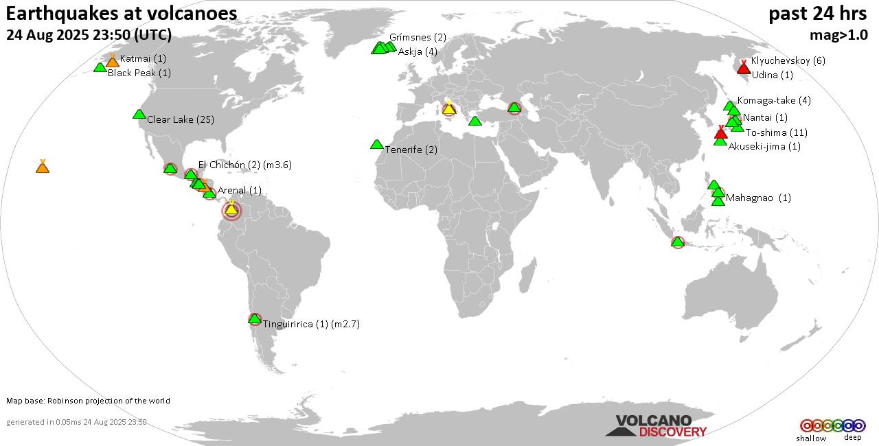 World map showing volcanoes with shallow (less than 50 km) earthquakes within 20 km radius during the past 24 hours on 24 Aug 2025 Number in brackets indicate nr of quakes. Quakes detected near: Akuseki-jima (2 quakes between mag 1.5-2.0), Arenal (1 quake mag 2.5), Askja (4 quakes between mag 0.5-1.1), Black Peak (1 quake mag 1.1), Brennisteinsfjöll (3 quakes between mag 1.0-1.6), Campi Flegrei (Phlegrean Fields) (15 quakes between mag 0.1-2.4)
Canlaon (1 quake mag 1.2), Cerro Singüil (3 quakes between mag 2.2-2.5), Chiquimula Volcanic Field (1 quake mag 3.0), Clear Lake (25 quakes between mag 0.2-1.7), El Chichón (5 quakes between mag 2.0-3.6), Eldey (3 quakes between mag 1.2-1.4), Fourpeaked (1 quake mag 1.3), Grímsnes (1 quake mag 1.1), Grímsvötn (1 quake mag 1.4), Guntur (1 quake mag 2.6), Hiuchi (7 quakes between mag 0.3-2.5), Hrómundartindur (5 quakes between mag 0.2-1.1), Katmai (1 quake mag 1.2), Kilauea (2 quakes between mag 1.9-2.3), Kirishima (5 quakes between mag 0.1-1.1), Kolumbo (4 quakes between mag 1.4-2.2), Komaga-take (5 quakes between mag 0.3-1.0), Ljósufjöll (2 quakes between mag 1.1-1.3), Loki-Fögrufjöll volcano (2 quakes between mag 1.1-1.1), Machin (1 quake mag 3.0), Mahagnao (1 quake mag 2.0), Michoacán-Guanajuato (4 quakes between mag 1.9-2.7), Nantai (1 quake mag 1.2), Norikura (5 quakes between mag 0.3-1.5), Osore-yama (3 quakes between mag 0.2-1.5), Pacaya (1 quake mag 3.0), Prestahnukur (1 quake mag 1.7), Ragang (1 quake mag 1.5), San Salvador (1 quake mag 3.0), Sangay (Philippines) (1 quake mag 1.8), Telica (1 quake mag 1.5), Tenerife (2 quakes between mag 1.4-1.5), Tinguiririca (1 quake mag 2.7), Tjörnes Fracture Zone (3 quakes between mag 0.3-1.1), To-shima (10 quakes between mag 0.7-1.9), Unzen (7 quakes between mag 0.1-1.6), Vesuvius (5 quakes between mag 0.1-1.2) (updated 20h50)
Note: Earthquakes within 20 km from and at depths less than 50 km under active volcanoes are reported. The list is not complete because many volcanoes are not monitored and/or seismic data in high resolution is not available publicly.
Volcanoes with recent earthquakes above magnitude 2 or more than 10 quakes are listed below:
Arenal volcano (Costa Rica): magnitude 2.5 earthquakeA magnitude 2.5 earthquake occurred at the volcano 16 hours ago. The quake, which might be volcanic in origin, was located at a depth of 9.00 km depth at 14 km distance NW from the volcano. Earthquake details: 2.5 quake 47 km northwest of Quesada, Provincia de Alajuela, Costa Rica, Aug 23, 2025 11:15 pm (GMT -6) (14 km NW) All earthquakes at ArenalCampi Flegrei (Phlegrean Fields) volcano (Italy): 15 earthquakes up to magnitude 2.4Possible earthquake swarm: 15 earthquakes occurred near (under) the volcano during 18 hours, the last being recorded quake 6 hours ago. Hypocenter depths ranged between 2.81 and 0.42 km. Earthquake details: (only 5 largest) 2.4 quake 11 km west of Naples, Napoli, Campania, Italy, Aug 23, 2025 10:57 pm (GMT +2) (2 km SSE) 2.0 quake 2.4 km southwest of Pozzuoli, Napoli, Campania, Italy, Aug 24, 2025 03:54 pm (GMT +2) (5 km W) 1.6 quake 4.8 km southeast of Pozzuoli, Napoli, Campania, Italy, Aug 23, 2025 11:00 pm (GMT +2) (1 km S) 1.6 quake 4.8 km southeast of Pozzuoli, Napoli, Campania, Italy, Aug 23, 2025 10:55 pm (GMT +2) (1 km S) 1.4 quake 4.6 km southeast of Pozzuoli, Napoli, Campania, Italy, Aug 24, 2025 05:45 am (GMT +2) (1 km SSE) All earthquakes at Campi Flegrei (Phlegrean Fields)Cerro Singüil volcano (El Salvador): 3 earthquakes up to magnitude 2.53 earthquakes occurred near (under) the volcano during 14 hours, the last being recorded quake 5 hours ago. Hypocenter depths ranged between 9.00 and 5.00 km. Earthquake details: 2.5 quake 24 km southeast of Jutiapa, Departamento de Jutiapa, Guatemala, Aug 23, 2025 07:26 pm (GMT -6) (18 km WNW) 2.3 quake 16 km north of Ahuachapan, Departamento de Ahuachapan, El Salvador, Aug 24, 2025 06:45 am (GMT -6) (18 km W) 2.2 quake 15 km northeast of Ahuachapan, Departamento de Ahuachapan, El Salvador, Aug 24, 2025 09:46 am (GMT -6) (15 km W) All earthquakes at Cerro SingüilChiquimula Volcanic Field volcano (Guatemala): magnitude 3.0 earthquakeA magnitude 3.0 earthquake occurred at the volcano 24 hours ago. The quake, which might be volcanic in origin, was located at a depth of 10.00 km depth at 11 km distance NNW from the volcano. Earthquake details: Reported seismic-like event (likely no quake): 14 km north of Chiquimula, Departamento de Chiquimula, Guatemala, Aug 23, 2025 03:00 pm (GMT -6) (11 km NNW) All earthquakes at Chiquimula Volcanic FieldClear Lake volcano (California): 25 earthquakes up to magnitude 1.7Possible earthquake swarm: 25 earthquakes occurred near (under) the volcano during 23 hours, the last being recorded quake 12 minutes ago. Hypocenter depths ranged between 6.20 and 1.21 km. Earthquake details: (only 5 largest) 1.7 quake Sonoma County, 13 mi southwest of Clearlake, Lake County, California, United States, Aug 24, 2025 03:39 am (GMT -7) (17 km S) 1.4 quake 28 mi north of Santa Rosa, Sonoma County, California, United States, Aug 24, 2025 06:17 am (GMT -7) (16 km SSW) 1.4 quake 27 mi north of Santa Rosa, Sonoma County, California, United States, Aug 23, 2025 10:33 pm (GMT -7) (17 km S) 1.4 quake 28 mi north of Santa Rosa, Sonoma County, California, United States, Aug 24, 2025 07:57 am (GMT -7) (16 km SSW) 1.1 quake 27 mi north of Santa Rosa, Sonoma County, California, United States, Aug 24, 2025 01:18 am (GMT -7) (16 km S) All earthquakes at Clear LakeEl Chichón volcano (Southern Mexico): 5 earthquakes up to magnitude 3.65 earthquakes occurred near (under) the volcano during 3 hours, the last being recorded quake 20 hours ago. Hypocenter depths ranged between 11.80 and 2.00 km. Earthquake details: 3.6 quake 64 km north of Tuxtla, Estado de Chiapas, Mexico, Aug 23, 2025 07:09 pm (GMT -6) (8 km SW) 2.7 quake Estado de Chiapas, 41 km southwest of Teapa, Estado de Tabasco, Mexico, Aug 23, 2025 03:48 pm (GMT -6) (9 km WNW) 2.4 quake Estado de Chiapas, 40 km south of Huimanguillo, Estado de Tabasco, Mexico, Aug 23, 2025 07:12 pm (GMT -6) (17 km NW) 2.0 quake 6.4 km southeast of Ostuacan, Estado de Chiapas, Mexico, Aug 23, 2025 05:30 pm (GMT -6) (6 km WNW) 2.0 quake Estado de Chiapas, 37 km southwest of Teapa, Estado de Tabasco, Mexico, Aug 23, 2025 03:52 pm (GMT -6) (2 km WNW) All earthquakes at El ChichónGuntur volcano (West Java): magnitude 2.6 earthquakeA magnitude 2.6 earthquake occurred at the volcano 14 hours ago. The quake, which might be volcanic in origin, was located at a depth of 10.00 km depth at 1 km distance N from the volcano. Earthquake details: 2.6 quake Kabupaten Garut, 9.5 km southeast of Paseh, Indonesia, Aug 24, 2025 02:13 pm (GMT +7) (1 km N) All earthquakes at GunturHiuchi volcano (Honshu): 7 earthquakes up to magnitude 2.57 earthquakes occurred near (under) the volcano during 22 hours, the last being recorded quake 2 hours ago. Hypocenter depths ranged between 7.50 and 4.20 km. Earthquake details: (only 5 largest) 2.5 quake Fukushima, 45 km east of Minamiuonuma, Niigata, Japan, Aug 24, 2025 03:00 pm (GMT +9) (19 km NE) 1.1 quake Fukushima, 35 km northwest of Imaichi, Tochigi, Japan, Aug 24, 2025 05:51 am (GMT +9) (17 km ENE) 1.0 quake Japan: Western Fukushima Pref Aug 25, 2025 12:04 am (GMT +9) (14 km NE) 0.9 quake Fukushima, 44 km northwest of Imaichi, Tochigi, Japan, Aug 25, 2025 03:37 am (GMT +9) (11 km NE) 0.5 quake Fukushima, 45 km northwest of Imaichi, Tochigi, Japan, Aug 24, 2025 06:55 pm (GMT +9) (5 km NNE) All earthquakes at HiuchiKilauea volcano (Hawai'i (Big Island)): 2 earthquakes up to magnitude 2.32 earthquakes occurred near (under) the volcano at nearly the same time (15:54 UTC). Hypocenter depths ranged between 4.01 and 1.53 km. Earthquake details: 2.3 quake 25 mi south of Hilo, Hawaii County, Hawaii, United States, Aug 24, 2025 05:54 am (GMT -10) (16 km ESE) 1.9 quake 28 mi south of Hilo, Hawaii County, Hawaii, United States, Aug 24, 2025 05:54 am (GMT -10) (18 km ESE) All earthquakes at KilaueaKolumbo volcano (Greece): 4 earthquakes up to magnitude 2.24 earthquakes occurred near (under) the volcano during 20 hours, the last being recorded quake 1 hour 15 minutes ago. Hypocenter depths ranged between 27.00 and 5.00 km. Earthquake details: 2.2 quake Aegean Sea, 21 km northeast of Santorini Island, Greece, Aug 24, 2025 01:26 pm (GMT +3) (10 km ENE) 1.7 quake Aegean Sea, 19 km northeast of Santorini Island, Greece, Aug 24, 2025 10:34 pm (GMT +3) (9 km E) 1.7 quake Aegean Sea, 27 km northeast of Santorini Island, Greece, Aug 24, 2025 02:33 am (GMT +3) (18 km ENE) 1.4 quake Aegean Sea, 23 km northeast of Santorini Island, Greece, Aug 24, 2025 03:04 am (GMT +3) (13 km ENE) All earthquakes at KolumboMachin volcano (Colombia): magnitude 3.0 earthquakeA magnitude 3.0 earthquake occurred at the volcano 18 hours ago. The quake, which might be volcanic in origin, was located at a depth of 10.00 km depth at 16 km distance ESE from the volcano. Earthquake details: Reported seismic-like event (likely no quake): 2.9 km southwest of Ibague, Departamento de Tolima, Colombia, Aug 23, 2025 10:14 pm (GMT -5) (16 km ESE) All earthquakes at MachinMichoacán-Guanajuato volcano (Western & Central Mexico): 4 earthquakes up to magnitude 2.74 earthquakes occurred near (under) the volcano during 3 hours, the last being recorded quake 14 hours ago. Hypocenter depths ranged between 26.50 and 15.00 km. Earthquake details: 2.7 quake 16 km southwest of Uruapan, Estado de Michoacan de Ocampo, Mexico, Aug 24, 2025 12:41 am (GMT -6) (19 km SSE) 2.7 quake 26 km west of Uruapan, Estado de Michoacan de Ocampo, Mexico, Aug 24, 2025 01:11 am (GMT -6) (16 km SSW) 2.6 quake 17 km west of Uruapan, Estado de Michoacan de Ocampo, Mexico, Aug 23, 2025 10:18 pm (GMT -6) (7 km SSE) 1.9 quake 27 km north of Apatzingan, Estado de Michoacan de Ocampo, Mexico, Aug 24, 2025 12:29 am (GMT -6) (19 km SSW) All earthquakes at Michoacán-GuanajuatoPacaya volcano (Guatemala): magnitude 3.0 earthquakeA magnitude 3.0 earthquake occurred at the volcano 17 hours ago. The quake, which might be volcanic in origin, was located at a depth of 10.00 km depth at 14 km distance N from the volcano. Earthquake details: Reported seismic-like event (likely no quake): 17 km southwest of Guatemala City, Departamento de Guatemala, Guatemala, Aug 23, 2025 10:00 pm (GMT -6) (14 km N) All earthquakes at PacayaSan Salvador volcano (El Salvador): magnitude 3.0 earthquakeA magnitude 3.0 earthquake occurred at the volcano 20 hours ago. The quake, which might be volcanic in origin, was located at a depth of 10.00 km depth at 5 km distance ESE from the volcano. Earthquake details: Reported seismic-like event (likely no quake): 7.6 km west of San Salvador, Departamento de San Salvador, El Salvador, Aug 23, 2025 07:16 pm (GMT -6) (5 km ESE) All earthquakes at San SalvadorTinguiririca volcano (Central Chile and Argentina): magnitude 2.7 earthquakeA magnitude 2.7 earthquake occurred at the volcano 18 hours ago. The quake, which might be volcanic in origin, was located at a depth of 5.00 km depth at 18 km distance SSW from the volcano. Earthquake details: 2.7 quake Provincia de Colchagua, 94 km south of Rancagua, Provincia de Cachapoal, Region del Libertador General Bernardo O'Higgins, Chile, Aug 23, 2025 10:39 pm (GMT -4) (18 km SSW) All earthquakes at Tinguiriricahttps://www.volcanodiscovery.com/earthquakes-volcanoes/news/278765/Volcano-earthquake-report-for-Sunday-24-Aug-2025.html
|
|


CMS The Best Conveyancing solicitors conveyancing quotes throughout the UK
For any webhosting enquiries please email webmaster@aus-city.com
|
|
Entire Thread
|
 Volcano earthquake report for Sunday, 24 Aug 2025
|
Webmaster
|
Sun 24 Aug 2025 08:50:PM
|
|
Forums60
Topics793,578
Posts828,362
Members2,960
| |
Most Online102,106
Jul 10th, 2026
|
|
|
|
|
Copyright 1996 - 2026 by David Cottle. Designed by David Bate Jr. All Rights Reserved.
By using this forum, the user agrees not to transfer any data or technical information received under this agreement to any other entity without the express approval of the AUS-CITY Forum Admins and/or authors of individual posts (Forum Admins and DoD/USSPACECOM for the analysis of satellite tracking data).
Two-line elements (TLE) and all other satellite data presented and distributed via this forum and AUS-CITY mailing lists are distributed with permission from DoD/USSTRATCOM.

|

|


 - Click image for larger picture.")


