|
1 members (Alisa),
2,656
guests, and
53
robots. |
|
Key:
Admin,
Global Mod,
Mod
|
|
S |
M |
T |
W |
T |
F |
S |
|
|
|
|
|
|
|
1
|
|
2
|
3
|
4
|
5
|
6
|
7
|
8
|
|
9
|
10
|
11
|
12
|
13
|
14
|
15
|
|
16
|
17
|
18
|
19
|
20
|
21
|
22
|
|
23
|
24
|
25
|
26
|
27
|
28
|
29
|
|
30
|
31
|
|
|
|
|
|
|
There are no members with birthdays on this day. |

Volcano earthquake report for Friday, 31 Jul 2026
• World Earthquake Report for Friday, 31 July 2026
• Light mag. 3.9 earthquake - Philippine Sea, 57 km east of Sulangan, Philipp...
• Small tremor of magnitude 3.1 just reported 10 km southwest of Naples, Ital...
• Seismic-like event, possible earthquake, reported few minutes ago near Napl...
• Strong mag. 5.0 earthquake - 65 km northeast of Pu'er, Yunnan Sheng, China,...
|

#787510
Wed 03 Dec 2025 02:03:AM
|
Joined: Feb 2001
Posts: 678,976
Launch Director
|
OP

Launch Director
Joined: Feb 2001
Posts: 678,976 |
SPC MD 2249MD 2249 CONCERNING HEAVY SNOW FOR COASTAL NORTHERN NEW ENGLAND 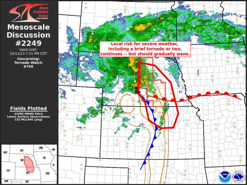
Mesoscale Discussion 2249
NWS Storm Prediction Center Norman OK
0712 PM CST Tue Dec 02 2025

Areas affected...coastal northern New England

Concerning...Heavy snow

Valid 030112Z - 030715Z

SUMMARY...Moderate to heavy snow rates on the order of 1/2 to 1+
inches per hour are possible across southern Maine this evening,
with heaviest rates most probable near Down East coastal areas
closer to and after Midnight EST, as strengthening and gusty winds
contribute to reduced visibilities and blowing/drifting.

DISCUSSION...A deepening surface cyclone is forecast to continue an
east-northeastward migration, generally south through east of the
Cape Cod vicinity through mid to late evening.  This will be
accompanied by a zone of strengthening lower/mid-tropospheric
frontogenetic forcing to its north through northeast.  At
mid-levels, the Rapid Refresh indicates that this will shift across
southern Maine through southern New Brunswick, where forecast
soundings indicate that  strengthening lift in (roughly) the 600-500
mb layer may coincide with temperatures most conducive to large
dendritic ice crystal growth (around -15 C).

There is notable spread within and among the various model output
concerning these details, and potentially varying rates of cyclone
and upward vertical motion intensification.  However, in the
presence of sub-freezing thermodynamic profiles, guidance generally
indicates snow rates on the order of 1/2 to 1 inch per hour are
possible this evening across much of southern Maine.  Heaviest rates
appear most probable near immediate coastal areas of Maine,
particularly across Down East coastal Maine closer to and after
05-06Z, when strengthening and gusty east-northeasterly surface
winds may contribute to considerable blowing/drifting and reduced
visibilities.

..Kerr.. 12/03/2025

...Please see www.spc.noaa.gov for graphic product...

ATTN...WFO...CAR...GYX...

LAT...LON   43277133 44757076 45456714 44046610 43626951 43127081
            43277133
Read morehttps://www.spc.noaa.gov/products/md/md2249.html
|
|


CMS The Best Conveyancing solicitors conveyancing quotes throughout the UK
For any webhosting enquiries please email webmaster@aus-city.com
|
|
Entire Thread
|
 SPC MD 2249
|
Webmaster
|
Wed 03 Dec 2025 02:03:AM
|
|
Forums60
Topics793,578
Posts828,362
Members2,960
| |
Most Online102,106
Jul 10th, 2026
|
|
|


 - Click image for larger picture.")


