|
|
|
0 members (),
6,707
guests, and
24
robots. |
|
Key:
Admin,
Global Mod,
Mod
|
|
S |
M |
T |
W |
T |
F |
S |
|
1
|
2
|
3
|
4
|
5
|
6
|
7
|
|
8
|
9
|
10
|
11
|
12
|
13
|
14
|
|
15
|
16
|
17
|
18
|
19
|
20
|
21
|
|
22
|
23
|
24
|
25
|
26
|
27
|
28
|
|
29
|
30
|
31
|
|
|
|
|
|
There are no members with birthdays on this day. |

#792000
Sat 10 Jan 2026 03:50:PM
|
Joined: Feb 2001
Posts: 381,904
Launch Director
|
OP

Launch Director
Joined: Feb 2001
Posts: 381,904 |
Volcano earthquake report for Saturday, 10 Jan 2026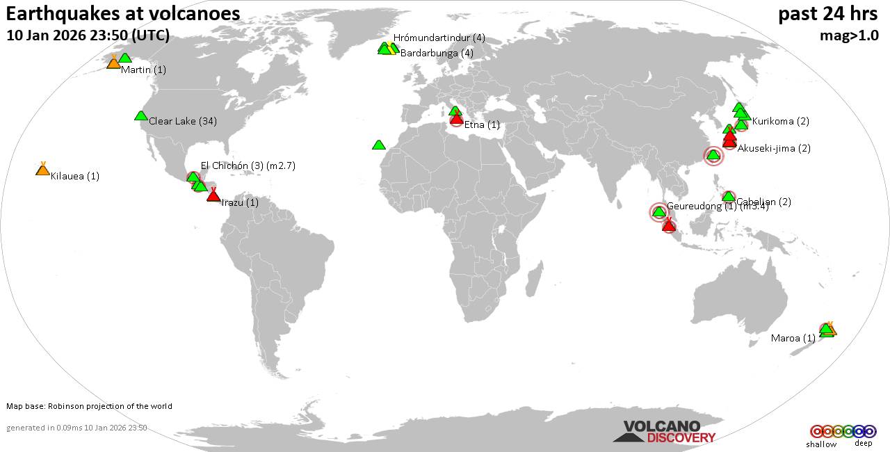 World map showing volcanoes with shallow (less than 50 km) earthquakes within 20 km radius during the past 24 hours on 10 Jan 2026 Number in brackets indicate nr of quakes. Quakes detected near: Abu (4 quakes between mag 0.5-1.5), Agua (2 quakes between mag 2.4-2.6), Akita-Komagatake (3 quakes between mag 0.5-1.4), Akuseki-jima (2 quakes between mag 2.0-2.0), Apaneca Range (4 quakes between mag 1.8-3.3), Askja (2 quakes between mag 0.1-2.3)
Auckland Field (1 quake mag 2.2), Bardarbunga (4 quakes between mag 0.4-1.2), Brennisteinsfjöll (8 quakes between mag 0.3-1.3), Cabalian (2 quakes between mag 2.3-2.3), Clear Lake (31 quakes between mag 0.2-1.8), El Chichón (5 quakes between mag 2.1-2.8), Etna (2 quakes between mag 2.0-3.3), Fuego (1 quake mag 2.9), Geureudong (1 quake mag 3.4), Hrómundartindur (5 quakes between mag 0.2-1.4), Katmai (3 quakes between mag 1.0-1.2), Kilauea (1 quake mag 1.6), Kirishima (3 quakes between mag 0.2-1.7), Kuchinoshima (1 quake mag 1.2), Kurikoma (1 quake mag 1.3), La Palma (2 quakes between mag 1.7-1.8), Lewotolo (1 quake mag 2.8), Loki-Fögrufjöll volcano (2 quakes between mag 0.7-1.4), Marapi (1 quake mag 2.6), Maroa (2 quakes between mag 1.7-1.9), Martin (1 quake mag 1.4), Maunaloa (2 quakes between mag 1.7-1.8), Megata (2 quakes between mag 1.3-1.6), Okataina (Tarawera) (1 quake mag 2.3), Ontake-san (6 quakes between mag 0.1-2.7), Paco (1 quake mag 3.0), Redoubt (1 quake mag 1.9), Reporoa (3 quakes between mag 1.5-1.6), Rotorua (1 quake mag 2.4), Sumbing (1 quake mag 2.3), Suwanose-jima (1 quake mag 2.1), Tatun Group (1 quake mag 3.0), Tenerife (2 quakes between mag 0.9-1.1), Toba (1 quake mag 2.0), Vesuvius (1 quake mag 1.6), White Island (4 quakes between mag 2.1-3.2) (updated 15h50)
Note: Earthquakes within 20 km from and at depths less than 50 km under active volcanoes are reported. The list is not complete because many volcanoes are not monitored and/or seismic data in high resolution is not available publicly.
Volcanoes with recent earthquakes above magnitude 2 or more than 10 quakes are listed below:
Agua volcano (Guatemala): 2 earthquakes up to magnitude 2.62 earthquakes occurred near (under) the volcano during 11 hours, the last being recorded quake 12 hours ago. Hypocenter depths ranged between 7.00 and 1.00 km. Earthquake details: 2.6 quake Departamento de Sacatepequez, 19 km southwest of Guatemala City, Guatemala, Jan 9, 2026 10:39 am (GMT -6) (12 km NE) 2.4 quake 10.5 km northeast of Escuintla, Departamento de Escuintla, Guatemala, Jan 9, 2026 10:00 pm (GMT -6) (11 km SSE) All earthquakes at AguaApaneca Range volcano (El Salvador): 4 earthquakes up to magnitude 3.34 earthquakes occurred near (under) the volcano during 14 hours, the last being recorded quake 10 hours ago. Hypocenter depths ranged between 10.00 and 4.00 km. Earthquake details: 3.3 quake 14 km north of Sonsonate, Departamento de Sonsonate, El Salvador, Jan 9, 2026 09:56 am (GMT -6) (7 km SSE) 2.1 quake 14 km north of Sonsonate, Departamento de Sonsonate, El Salvador, Jan 9, 2026 12:24 pm (GMT -6) (6 km SSE) 1.8 quake 14 km north of Sonsonate, Departamento de Sonsonate, El Salvador, Jan 9, 2026 11:45 pm (GMT -6) (7 km SSE) 1.8 quake 15 km north of Sonsonate, Departamento de Sonsonate, El Salvador, Jan 9, 2026 02:13 pm (GMT -6) (5 km SE) All earthquakes at Apaneca RangeAskja volcano (Iceland): 2 earthquakes up to magnitude 2.32 earthquakes occurred near (under) the volcano during 19 hours, the last being recorded quake 4 hours ago. Hypocenter depths ranged between 4.40 and 2.80 km. Earthquake details: 2.3 quake 1.8 km SW of Víti Jan 9, 2026 04:52 pm (Universal Time) (1 km N) 0.1 quake Iceland: 1.2 km E of Suðurbotnar Jan 10, 2026 12:04 pm (Reykjavik time) (4 km ESE) All earthquakes at AskjaAuckland Field volcano (North Island): magnitude 2.2 earthquakeA magnitude 2.2 earthquake occurred at the volcano 42 minutes ago. The quake, which might be volcanic in origin, was located at a depth of 8.70 km depth at 15 km distance NNW from the volcano. Earthquake details: 2.2 quake South Pacific Ocean, Auckland, 27 km west of Waiheke Island, New Zealand, Jan 11, 2026 04:08 am (GMT +13) (15 km NNW) All earthquakes at Auckland FieldCabalian volcano (Central Philippines): 2 earthquakes up to magnitude 2.32 earthquakes occurred near (under) the volcano during 7 hours, the last being recorded quake 9 hours ago. Hypocenter depths ranged between 4.00 and 2.00 km. Earthquake details: 2.3 quake Philippine Sea, 44 km southeast of Abuyog, Philippines, Jan 10, 2026 02:34 pm (GMT +8) (13 km N) 2.3 quake Province of Southern Leyte, 48 km east of Inopacan, Philippines, Jan 10, 2026 07:57 am (GMT +8) (17 km NNW) All earthquakes at CabalianClear Lake volcano (California): 31 earthquakes up to magnitude 1.8Possible earthquake swarm: 31 earthquakes occurred near (under) the volcano during 22 hours, the last being recorded quake 1 hour 30 minutes ago. Hypocenter depths ranged between 3.64 and 0.53 km. Earthquake details: (only 5 largest) 1.8 quake Sonoma County, 14 mi southwest of Clearlake, Lake County, California, United States, Jan 10, 2026 12:25 am (GMT -8) (18 km SSW) 1.6 quake Sonoma County, 14 mi southwest of Clearlake, Lake County, California, United States, Jan 9, 2026 04:54 pm (GMT -8) (16 km SSW) 1.5 quake 29 mi north of Santa Rosa, Sonoma County, California, United States, Jan 9, 2026 09:52 pm (GMT -8) (15 km SSW) 1.4 quake 27 mi north of Santa Rosa, Sonoma County, California, United States, Jan 10, 2026 03:58 am (GMT -8) (17 km S) 1.2 quake Lake County, 28 mi north of Santa Rosa, Sonoma County, California, United States, Jan 10, 2026 06:20 am (GMT -8) (15 km S) All earthquakes at Clear LakeEl Chichón volcano (Southern Mexico): 5 earthquakes up to magnitude 2.85 earthquakes occurred near (under) the volcano during 12 hours, the last being recorded quake 5 hours ago. Hypocenter depths ranged between 3.80 and 2.10 km. Earthquake details: 2.8 quake Estado de Chiapas, 37 km southwest of Teapa, Estado de Tabasco, Mexico, Jan 9, 2026 05:23 pm (GMT -6) (2 km NW) 2.7 quake Estado de Chiapas, 37 km southwest of Teapa, Estado de Tabasco, Mexico, Jan 10, 2026 12:16 am (GMT -6) (1 km NW) 2.5 quake Estado de Chiapas, 37 km southwest of Teapa, Estado de Tabasco, Mexico, Jan 10, 2026 12:27 am (GMT -6) (0 km WSW) 2.3 quake Estado de Chiapas, 37 km southwest of Teapa, Estado de Tabasco, Mexico, Jan 10, 2026 04:59 am (GMT -6) (0 km NW) 2.1 quake Estado de Chiapas, 36 km southwest of Teapa, Estado de Tabasco, Mexico, Jan 9, 2026 05:12 pm (GMT -6) (1 km N) All earthquakes at El ChichónEtna volcano (Italy): 2 earthquakes up to magnitude 3.32 earthquakes occurred near (under) the volcano during 5 hours, the last being recorded quake 14 hours ago. Hypocenter depths ranged between 9.50 and 7.01 km. Earthquake details: 3.3 quake 7.7 km north of Adrano, Catania, Sicily, Italy, Jan 9, 2026 10:33 pm (GMT +1) (13 km W) 2.0 quake 7.2 km north of Adrano, Catania, Sicily, Italy, Jan 10, 2026 03:08 am (GMT +1) (16 km W) All earthquakes at EtnaFuego volcano (Guatemala): magnitude 2.9 earthquakeA magnitude 2.9 earthquake occurred at the volcano 23 hours ago. The quake, which might be volcanic in origin, was located at a depth of 1.00 km depth at 14 km distance S from the volcano. Earthquake details: 2.9 quake 12 km northwest of Escuintla, Departamento de Escuintla, Guatemala, Jan 9, 2026 10:50 am (GMT -6) (14 km S) All earthquakes at FuegoGeureudong volcano (Sumatra): magnitude 3.4 earthquakeA magnitude 3.4 earthquake occurred at the volcano 42 minutes ago. The quake, which might be volcanic in origin, was located at a depth of 4.00 km depth at 16 km distance NNW from the volcano. Earthquake details: 3.4 quake Kabupaten Bener Meriah, 34 km south of Bireun, Indonesia, Jan 10, 2026 10:08 pm (GMT +7) (16 km NNW) All earthquakes at GeureudongLewotolo volcano (Lesser Sunda Islands): magnitude 2.8 earthquakeA magnitude 2.8 earthquake occurred at the volcano 18 hours ago. The quake, which might be volcanic in origin, was located at a depth of 5.00 km depth at 18 km distance WNW from the volcano. Earthquake details: 2.8 quake Banda Sea, 25 km northeast of Pulau Adonara Island, Indonesia, Jan 10, 2026 05:26 am (GMT +8) (18 km WNW) All earthquakes at LewotoloMarapi volcano (Sumatra): magnitude 2.6 earthquakeA magnitude 2.6 earthquake occurred at the volcano 9 hours ago. The quake, which might be volcanic in origin, was located at a depth of 7.00 km depth at 6 km distance NNE from the volcano. Earthquake details: 2.6 quake Kabupaten Agam, 22 km southwest of Payakumbuh, Indonesia, Jan 10, 2026 01:34 pm (GMT +7) (6 km NNE) All earthquakes at MarapiOkataina (Tarawera) volcano (New Zealand): magnitude 2.3 earthquakeA magnitude 2.3 earthquake occurred at the volcano 8 hours ago. The quake, which might be volcanic in origin, was located at a depth of 4.30 km depth at 13 km distance E from the volcano. Earthquake details: 2.3 quake 36 km east of Rotorua, Bay of Plenty, New Zealand, Jan 10, 2026 08:35 pm (GMT +13) (13 km E) All earthquakes at Okataina (Tarawera)Ontake-san volcano (Honshu): 6 earthquakes up to magnitude 2.76 earthquakes occurred near (under) the volcano during 12 hours, the last being recorded quake 12 hours ago. Hypocenter depths ranged between 16.70 and 3.80 km. Earthquake details: (only 5 largest) 2.7 quake 42 km northwest of Iida, Nagano, Japan, Jan 10, 2026 11:22 am (GMT +9) (10 km SSE) 0.2 quake 20 km south of Takayama, Gifu, Japan, Jan 10, 2026 01:13 pm (GMT +9) (16 km WNW) 0.2 quake 29 km west of Ina, Nagano, Japan, Jan 10, 2026 10:54 am (GMT +9) (15 km E) 0.2 quake 32 km southeast of Takayama, Gifu, Japan, Jan 10, 2026 04:19 am (GMT +9) (13 km NNE) 0.1 quake 41 km northwest of Iida, Nagano, Japan, Jan 10, 2026 03:11 am (GMT +9) (11 km ESE) All earthquakes at Ontake-sanPaco volcano (Mindanao): magnitude 3.0 earthquakeA magnitude 3.0 earthquake occurred at the volcano 17 hours ago. The quake, which might be volcanic in origin, was located at a depth of 10.00 km depth at 16 km distance N from the volcano. Earthquake details: Reported seismic-like event (likely no quake): 7.8 km southeast of Surigao, Province of Surigao del Norte, Caraga, Philippines, Jan 10, 2026 06:51 am (GMT +8) (16 km N) All earthquakes at PacoRotorua volcano (New Zealand): magnitude 2.4 earthquakeA magnitude 2.4 earthquake occurred at the volcano 16 hours ago. The quake, which might be volcanic in origin, was located at a depth of 32.00 km depth at 16 km distance NNE from the volcano. Earthquake details: 2.4 quake 23 km north of Rotorua, Bay of Plenty, New Zealand, Jan 10, 2026 12:24 pm (GMT +13) (16 km NNE) All earthquakes at RotoruaSumbing volcano (Sumatra): magnitude 2.3 earthquakeA magnitude 2.3 earthquake occurred at the volcano 17 hours ago. The quake, which might be volcanic in origin, was located at a depth of 4.00 km depth at 3 km distance N from the volcano. Earthquake details: 2.3 quake Kabupaten Merangin, 53 km southeast of Sungai Penuh, Indonesia, Jan 10, 2026 05:57 am (GMT +7) (3 km N) All earthquakes at SumbingSuwanose-jima volcano (Ryukyu Islands): magnitude 2.1 earthquakeA magnitude 2.1 earthquake occurred at the volcano 12 hours ago. The quake, which might be volcanic in origin, was located at a depth of 4.00 km depth at 15 km distance SE from the volcano. Earthquake details: 2.1 quake East China Sea, Kagoshima-ken, 15 km southeast of Suwanose-jima Island, Japan, Jan 10, 2026 01:18 pm (GMT +9) (15 km SE) All earthquakes at Suwanose-jimaTatun Group volcano (Taiwan): magnitude 3.0 earthquakeA magnitude 3.0 earthquake occurred at the volcano 16 hours ago. The quake, which might be volcanic in origin, was located at a depth of 10.00 km depth at 15 km distance SSE from the volcano. Earthquake details: Reported seismic-like event (likely no quake): 3.8 km east of Taipei, Taiwan, Jan 10, 2026 08:15 am (GMT +8) (15 km SSE) All earthquakes at Tatun GroupWhite Island volcano (New Zealand): 4 earthquakes up to magnitude 3.24 earthquakes occurred near (under) the volcano during 7 minutes, the last being recorded quake 1 hour 4 minutes ago. Hypocenter depths ranged between 5.00 and 5.00 km. Earthquake details: 3.2 quake South Pacific Ocean, 57 km north of Whakatane, Bay of Plenty, New Zealand, Jan 11, 2026 03:40 am (GMT +13) (10 km NW) 2.8 quake South Pacific Ocean, 48 km north of Whakatane, Bay of Plenty, New Zealand, Jan 11, 2026 03:39 am (GMT +13) (4 km SW) 2.5 quake South Pacific Ocean, 62 km north of Whakatane, Bay of Plenty, New Zealand, Jan 11, 2026 03:46 am (GMT +13) (11 km NNW) 2.1 quake South Pacific Ocean, 49 km north of Whakatane, Bay of Plenty, New Zealand, Jan 11, 2026 03:38 am (GMT +13) (2 km SSW) All earthquakes at White Islandhttps://www.volcanodiscovery.com/earthquakes-volcanoes/news/291557/Volcano-earthquake-report-for-Saturday-10-Jan-2026.html
|
|


CMS The Best Conveyancing solicitors conveyancing quotes throughout the UK
For any webhosting enquiries please email webmaster@aus-city.com
|
|
Entire Thread
|
 Volcano earthquake report for Saturday, 10 Jan 2026
|
Webmaster
|
Sat 10 Jan 2026 03:50:PM
|
|
Forums60
Topics765,614
Posts800,366
Members2,958
| |
Most Online17,963
Jan 15th, 2026
|
|
|
|
|
Copyright 1996 - 2026 by David Cottle. Designed by David Bate Jr. All Rights Reserved.
By using this forum, the user agrees not to transfer any data or technical information received under the agreement, to any other entity without the express approval of the AUS-CITY Forum Admins and/or authors of individual posts (Forum Admins and DoD/USSPACECOM for the analysis of satellite tracking data).
Two-line elements (TLE) and all other satellite data presented and distributed via this forum and e-mail lists of AUS-CITY are distributed with permission from DoD/USSTRATCOM.

Reprise Hosting

|

|


 - Click image for larger picture.")


