|
|
|
0 members (),
953
guests, and
27
robots. |
|
Key:
Admin,
Global Mod,
Mod
|
|
S |
M |
T |
W |
T |
F |
S |
|
|
|
|
|
1
|
2
|
3
|
|
4
|
5
|
6
|
7
|
8
|
9
|
10
|
|
11
|
12
|
13
|
14
|
15
|
16
|
17
|
|
18
|
19
|
20
|
21
|
22
|
23
|
24
|
|
25
|
26
|
27
|
28
|
29
|
30
|
31
|
|
There are no members with birthdays on this day. |
|
|
|
|
|
|
|
|
|
|
|
|
SPC MD 31
by Webmaster - Thu 22 Jan 2026 03:16:AM
|
|
|
|
|
|
|
|
|
Joined: Feb 2001
Posts: 381,904
Launch Director
|
OP

Launch Director
Joined: Feb 2001
Posts: 381,904 |
Volcano earthquake report for Thursday, 22 Jan 2026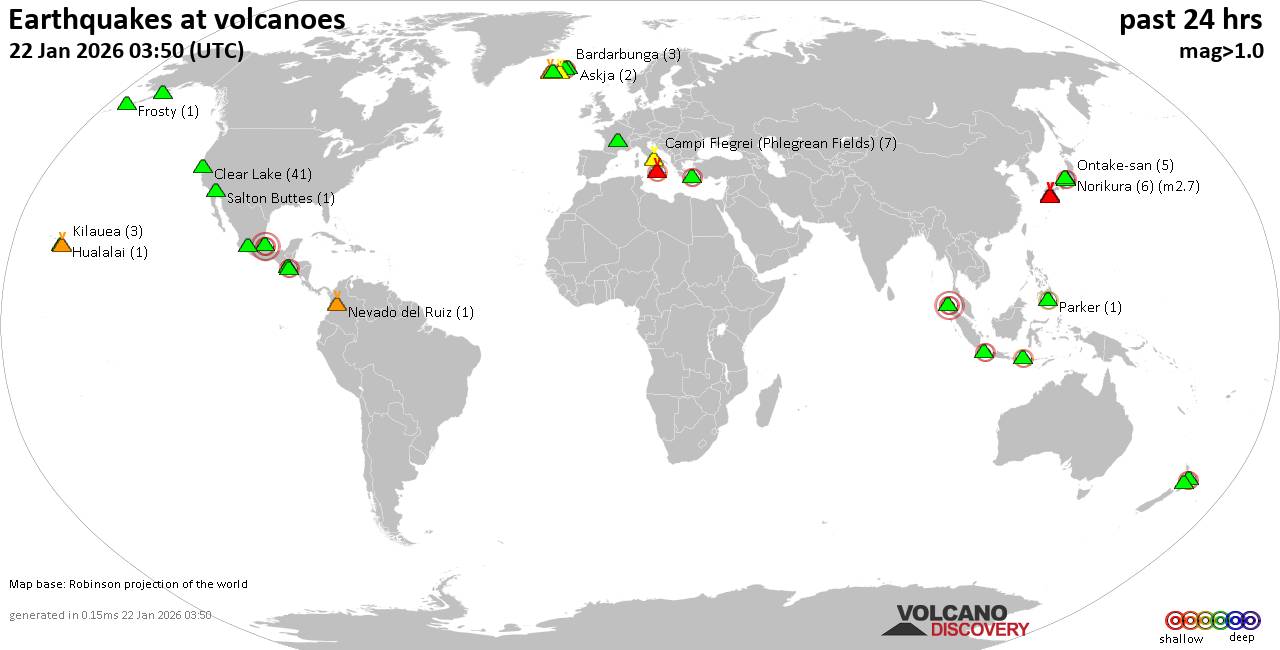 World map showing volcanoes with shallow (less than 50 km) earthquakes within 20 km radius during the past 24 hours on 22 Jan 2026 Number in brackets indicate nr of quakes. Quakes detected near: Apaneca Range (1 quake mag 2.1), Askja (2 quakes between mag 0.8-1.3), Bardarbunga (3 quakes between mag 0.5-2.1), Brennisteinsfjöll (14 quakes between mag 0.1-1.9), Campi Flegrei (Phlegrean Fields) (8 quakes between mag 0.1-1.7), Cerro Santiago (1 quake mag 2.7)
Chaîne des Puys (1 quake mag 1.3), Clear Lake (39 quakes between mag 0.2-1.8), Eldey (2 quakes between mag 0.9-1.0), Etna (2 quakes between mag 1.6-2.3), Frosty (1 quake mag 1.1), Gede-Pangrango (1 quake mag 2.3), Geureudong (1 quake mag 3.0), Hualalai (1 quake mag 1.7), Katla (2 quakes between mag 1.9-2.0), Kilauea (4 quakes between mag 1.8-2.3), Kirishima (1 quake mag 1.1), Kolumbo (1 quake mag 2.3), Los Humeros (1 quake mag 3.8), Martin (2 quakes between mag 0.3-1.6), Maunaloa (3 quakes between mag 2.0-2.2), Michoacán-Guanajuato (1 quake mag 2.4), Myoko (12 quakes between mag 0.1-1.2), Nevado del Ruiz (1 quake mag 1.1), Norikura (11 quakes between mag 0.2-2.8), Ontake-san (2 quakes between mag 0.4-1.3), Parker (1 quake mag 2.2), Reporoa (3 quakes between mag 1.9-2.1), Ruapehu (1 quake mag 1.4), Sakurajima (5 quakes between mag 0.2-1.6), Salton Buttes (1 quake mag 1.2), Tambora (1 quake mag 2.5), Washiba-Kumonotaira (9 quakes between mag 0.1-1.3), Wide Bay (1 quake mag 1.8) (updated 01h50)
Note: Earthquakes within 20 km from and at depths less than 50 km under active volcanoes are reported. The list is not complete because many volcanoes are not monitored and/or seismic data in high resolution is not available publicly.
Volcanoes with recent earthquakes above magnitude 2 or more than 10 quakes are listed below:
Apaneca Range volcano (El Salvador): magnitude 2.1 earthquakeA magnitude 2.1 earthquake occurred at the volcano 4 hours ago. The quake, which might be volcanic in origin, was located at a depth of 5.00 km depth at 5 km distance NE from the volcano. Earthquake details: 2.1 quake 9 km east of Ahuachapan, Departamento de Ahuachapan, El Salvador, Jan 21, 2026 03:25 pm (GMT -6) (5 km NE) All earthquakes at Apaneca RangeBardarbunga volcano (Iceland): 3 earthquakes up to magnitude 2.13 earthquakes occurred near (under) the volcano during 12 hours, the last being recorded quake 10 hours ago. Hypocenter depths ranged between 2.60 and 0.50 km. Earthquake details: 2.1 quake Iceland: 1.2 km NW of Bárðarbunga Jan 21, 2026 04:09 pm (Reykjavik time) (2 km NNW) 0.8 quake 5.7 km E of Bárðarbunga Jan 21, 2026 03:52 am (Universal Time) (6 km E) 0.5 quake Iceland: 8.7 km E of Bárðarbunga Jan 21, 2026 06:26 am (Reykjavik time) (9 km ENE) All earthquakes at BardarbungaBrennisteinsfjöll volcano (Reykjanes Peninsula, Iceland): 14 earthquakes up to magnitude 1.9Possible earthquake swarm: 14 earthquakes occurred near (under) the volcano during 15 hours, the last being recorded quake 7 hours ago. Hypocenter depths ranged between 12.20 and 4.10 km. Earthquake details: (only 5 largest) 1.9 quake 8.0 km ENE of Krýsuvík Jan 21, 2026 02:18 pm (Universal Time) (4 km WSW) 1.4 quake 8.0 km ENE of Krýsuvík Jan 21, 2026 02:18 pm (Universal Time) (4 km WSW) 1.2 quake 7.7 km E of Krýsuvík Jan 21, 2026 02:19 pm (Universal Time) (4 km WSW) 1.1 quake Iceland: 7.7 km ENE of Krýsuvík Jan 21, 2026 02:11 pm (Reykjavik time) (4 km WSW) 1.1 quake 7.6 km ENE of Krýsuvík Jan 21, 2026 02:20 pm (Universal Time) (4 km WSW) All earthquakes at BrennisteinsfjöllCerro Santiago volcano (Guatemala): magnitude 2.7 earthquakeA magnitude 2.7 earthquake occurred at the volcano 4 hours ago. The quake, which might be volcanic in origin, was located at a depth of 5.00 km depth at 7 km distance W from the volcano. Earthquake details: 2.7 quake 7.1 km northwest of Jutiapa, Departamento de Jutiapa, Guatemala, Jan 21, 2026 03:25 pm (GMT -6) (7 km W) All earthquakes at Cerro SantiagoClear Lake volcano (California): 39 earthquakes up to magnitude 1.8Possible earthquake swarm: 39 earthquakes occurred near (under) the volcano during 23 hours, the last being recorded quake 12 minutes ago. Hypocenter depths ranged between 7.73 and 0.98 km. Earthquake details: (only 5 largest) 1.8 quake Sonoma County, 14 mi southwest of Clearlake, Lake County, California, United States, Jan 21, 2026 04:13 pm (GMT -8) (16 km SSW) 1.7 quake Sonoma County, 14 mi southwest of Clearlake, Lake County, California, United States, Jan 21, 2026 10:21 am (GMT -8) (17 km S) 1.3 quake 28 mi north of Santa Rosa, Sonoma County, California, United States, Jan 21, 2026 02:23 pm (GMT -8) (16 km SSW) 1.3 quake 28 mi north of Santa Rosa, Sonoma County, California, United States, Jan 21, 2026 05:38 pm (GMT -8) (16 km SSW) 1.3 quake 29 mi north of Santa Rosa, Sonoma County, California, United States, Jan 20, 2026 08:02 pm (GMT -8) (14 km SSW) All earthquakes at Clear LakeEtna volcano (Italy): 2 earthquakes up to magnitude 2.32 earthquakes occurred near (under) the volcano during 4 hours, the last being recorded quake 16 hours ago. Hypocenter depths ranged between 12.87 and 11.95 km. Earthquake details: 2.3 quake 19 km northwest of Giarre, Catania, Sicily, Italy, Jan 21, 2026 10:26 am (GMT +1) (9 km N) 1.6 quake 18 km northeast of Bronte, Catania, Sicily, Italy, Jan 21, 2026 06:14 am (GMT +1) (11 km NNE) All earthquakes at EtnaGede-Pangrango volcano (West Java): magnitude 2.3 earthquakeA magnitude 2.3 earthquake occurred at the volcano 3 hours ago. The quake, which might be volcanic in origin, was located at a depth of 5.00 km depth at 17 km distance ESE from the volcano. Earthquake details: 2.3 quake 2.9 km southwest of Cianjur, Kabupaten Cianjur, Jawa Barat, Indonesia, Jan 22, 2026 06:15 am (GMT +7) (17 km ESE) All earthquakes at Gede-PangrangoGeureudong volcano (Sumatra): magnitude 3.0 earthquakeA magnitude 3.0 earthquake occurred at the volcano 10 hours ago. The quake, which might be volcanic in origin, was located at a depth of 10.00 km depth at 8 km distance SE from the volcano. Earthquake details: Reported seismic-like event (likely no quake): 59 km southwest of Lhokseumawe, Indonesia, Jan 21, 2026 10:56 pm (GMT +7) (8 km SE) All earthquakes at GeureudongKilauea volcano (Hawai'i (Big Island)): 4 earthquakes up to magnitude 2.34 earthquakes occurred near (under) the volcano during 8 hours, the last being recorded quake 15 hours ago. Hypocenter depths ranged between 47.40 and 4.09 km. Earthquake details: 2.3 quake 36 mi southwest of Hilo, Hawaii County, Hawaii, United States, Jan 20, 2026 06:57 pm (GMT -10) (19 km WSW) 2.1 quake 28 mi south of Hilo, Hawaii County, Hawaii, United States, Jan 20, 2026 06:57 pm (GMT -10) (11 km SE) 2.0 quake 36 mi southwest of Hilo, Hawaii County, Hawaii, United States, Jan 20, 2026 04:30 pm (GMT -10) (17 km SSW) 1.8 quake 37 mi southwest of Hilo, Hawaii County, Hawaii, United States, Jan 21, 2026 12:57 am (GMT -10) (18 km SSW) All earthquakes at KilaueaKolumbo volcano (Greece): magnitude 2.3 earthquakeA magnitude 2.3 earthquake occurred at the volcano 19 hours ago. The quake, which might be volcanic in origin, was located at a depth of 5.00 km depth at 13 km distance NE from the volcano. Earthquake details: 2.3 quake Aegean Sea, 25 km northeast of Santorini Island, Greece, Jan 21, 2026 08:59 am (GMT +2) (13 km NE) All earthquakes at KolumboLos Humeros volcano (Western & Central Mexico): magnitude 3.8 earthquakeA magnitude 3.8 earthquake occurred at the volcano 22 hours ago. The quake, which might be volcanic in origin, was located at a depth of 10.00 km depth at 19 km distance SSE from the volcano. Earthquake details: 3.8 quake 14 km west of Perote, Estado de Veracruz-Llave, Mexico, Jan 20, 2026 09:57 pm (GMT -6) (19 km SSE) All earthquakes at Los HumerosMaunaloa volcano (Hawai'i (Big Island)): 3 earthquakes up to magnitude 2.23 earthquakes occurred near (under) the volcano during 1 hour 24 minutes, the last being recorded quake 22 hours ago. Hypocenter depths ranged between 37.29 and 0.18 km. Earthquake details: 2.2 quake 38 mi southwest of Hilo, Hawaii County, Hawaii, United States, Jan 20, 2026 04:20 pm (GMT -10) (5 km SSE) 2.2 quake 29 mi southwest of Hilo, Hawaii County, Hawaii, United States, Jan 20, 2026 05:14 pm (GMT -10) (15 km E) 2.0 quake 28 mi southwest of Hilo, Hawaii County, Hawaii, United States, Jan 20, 2026 05:44 pm (GMT -10) (16 km ENE) All earthquakes at MaunaloaMichoacán-Guanajuato volcano (Western & Central Mexico): magnitude 2.4 earthquakeA magnitude 2.4 earthquake occurred at the volcano 17 hours ago. The quake, which might be volcanic in origin, was located at a depth of 24.30 km depth at 14 km distance SW from the volcano. Earthquake details: 2.4 quake 30 km west of Uruapan, Estado de Michoacan de Ocampo, Mexico, Jan 21, 2026 02:39 am (GMT -6) (14 km SW) All earthquakes at Michoacán-GuanajuatoMyoko volcano (Honshu): 12 earthquakes up to magnitude 1.2Possible earthquake swarm: 12 earthquakes occurred near (under) the volcano during 15 hours, the last being recorded quake 9 hours ago. Hypocenter depths ranged between 8.10 and 0.00 km. Earthquake details: (only 5 largest) 1.2 quake 39 km south of Joetsu, Niigata, Japan, Jan 21, 2026 12:01 pm (GMT +9) (8 km SSW) 1.1 quake 34 km south of Joetsu, Niigata, Japan, Jan 21, 2026 12:35 pm (GMT +9) (4 km S) 0.9 quake Niigata, 21 km northwest of Nagano, Nagano, Japan, Jan 21, 2026 10:01 pm (GMT +9) (9 km SSW) 0.7 quake Niigata, 21 km northwest of Nagano, Nagano, Japan, Jan 21, 2026 03:31 pm (GMT +9) (9 km SSW) 0.6 quake Niigata, 20 km northwest of Nagano, Nagano, Japan, Jan 22, 2026 01:46 am (GMT +9) (9 km SSW) All earthquakes at MyokoNorikura volcano (Honshu): 11 earthquakes up to magnitude 2.8Possible earthquake swarm: 11 earthquakes occurred near (under) the volcano during 7 hours, the last being recorded quake 16 hours ago. Hypocenter depths ranged between 7.00 and 3.40 km. Earthquake details: (only 5 largest) 2.8 quake 27 km east of Takayama, Gifu, Japan, Jan 21, 2026 12:14 pm (GMT +9) (2 km SSW) 2.8 quake 27 km east of Takayama, Gifu, Japan, Jan 21, 2026 12:14 pm (GMT +9) (2 km SSW) 2.7 quake 27 km east of Takayama, Gifu, Japan, Jan 21, 2026 12:56 pm (GMT +9) (2 km SSW) 0.9 quake 28 km east of Takayama, Gifu, Japan, Jan 21, 2026 12:15 pm (GMT +9) (1 km S) 0.5 quake 28 km east of Takayama, Gifu, Japan, Jan 21, 2026 12:13 pm (GMT +9) (1 km S) All earthquakes at NorikuraParker volcano (Mindanao): magnitude 2.2 earthquakeA magnitude 2.2 earthquake occurred at the volcano 6 hours ago. The quake, which might be volcanic in origin, was located at a depth of 33.00 km depth at 13 km distance WSW from the volcano. Earthquake details: 2.2 quake 35 km south of Surallah, Province of South Cotabato, Soccsksargen, Philippines, Jan 22, 2026 03:57 am (GMT +8) (13 km WSW) All earthquakes at ParkerReporoa volcano (New Zealand): 3 earthquakes up to magnitude 2.13 earthquakes occurred near (under) the volcano during 39 minutes, the last being recorded quake 1 hour 2 minutes ago. Hypocenter depths ranged between 5.00 and 3.40 km. Earthquake details: 2.1 quake 18 km northeast of Taupo, Waikato, New Zealand, Jan 22, 2026 01:47 pm (GMT +13) (19 km SSW) 2.0 quake 27 km southeast of Rotorua, Bay of Plenty, New Zealand, Jan 22, 2026 01:09 pm (GMT +13) (11 km NE) 1.9 quake 29 km southeast of Rotorua, Bay of Plenty, New Zealand, Jan 22, 2026 01:10 pm (GMT +13) (10 km NE) All earthquakes at ReporoaTambora volcano (Sumbawa): magnitude 2.5 earthquakeA magnitude 2.5 earthquake occurred at the volcano 18 hours ago. The quake, which might be volcanic in origin, was located at a depth of 16.00 km depth at 10 km distance SSE from the volcano. Earthquake details: 2.5 quake 53 km northwest of Dompu, Kabupaten Dompu, West Nusa Tenggara, Indonesia, Jan 21, 2026 03:53 pm (GMT +8) (10 km SSE) All earthquakes at Tamborahttps://www.volcanodiscovery.com/earthquakes-volcanoes/news/292586/Volcano-earthquake-report-for-Thursday-22-Jan-2026.html
|
|


CMS The Best Conveyancing solicitors conveyancing quotes throughout the UK
For any webhosting enquiries please email webmaster@aus-city.com
|
|
Entire Thread
|

 Volcano earthquake report for Thursday, 22 Jan 2026
|
Webmaster
|
4 hours ago
|
|
Forums60
Topics757,935
Posts792,642
Members2,958
| |
Most Online17,963
Jan 15th, 2026
|
|
|
|
|
Copyright 1996 - 2026 by David Cottle. Designed by David Bate Jr. All Rights Reserved.
By using this forum, the user agrees not to transfer any data or technical information received under the agreement, to any other entity without the express approval of the AUS-CITY Forum Admins and/or authors of individual posts (Forum Admins and DoD/USSPACECOM for the analysis of satellite tracking data).
Two-line elements (TLE) and all other satellite data presented and distributed via this forum and e-mail lists of AUS-CITY are distributed with permission from DoD/USSTRATCOM.

Reprise Hosting

|

|


 - Click image for larger picture.")


