|
|
|
0 members (),
780
guests, and
30
robots. |
|
Key:
Admin,
Global Mod,
Mod
|
|
S |
M |
T |
W |
T |
F |
S |
|
|
1
|
2
|
3
|
4
|
5
|
6
|
|
7
|
8
|
9
|
10
|
11
|
12
|
13
|
|
14
|
15
|
16
|
17
|
18
|
19
|
20
|
|
21
|
22
|
23
|
24
|
25
|
26
|
27
|
|
28
|
29
|
30
|
|
|
|
|
|
There are no members with birthdays on this day. |

Significant earthquake of magnitude 5.0 just reported 22 km southwest of Prosperidad, Philippines
• Strong mag. 5.0 earthquake - Mindanao, Philippines, on Tuesday, Jun 9, 2026...
• World Earthquake Report for Tuesday, 9 June 2026
• Moderate magnitude 4.8 earthquake 110 km southwest of Tambolaka, Indonesia
• Moderate mag. 4.8 earthquake - South of Sumbawa, Indonesia, on Tuesday, Jun...
• Volcano earthquake report for Tuesday, 9 Jun 2026
|

#796062
Fri 30 Jan 2026 11:50:AM
|
Joined: Feb 2001
Posts: 678,976
Launch Director
|
OP

Launch Director
Joined: Feb 2001
Posts: 678,976 |
Volcano earthquake report for Friday, 30 Jan 2026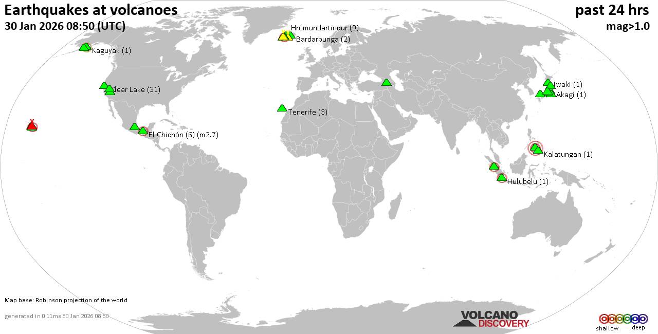 World map showing volcanoes with shallow (less than 50 km) earthquakes within 20 km radius during the past 24 hours on 30 Jan 2026 Number in brackets indicate nr of quakes. Quakes detected near: Aragats (1 quake mag 1.8), Bardarbunga (5 quakes between mag 0.0-1.6), Brennisteinsfjöll (5 quakes between mag 0.4-2.0), Clear Lake (31 quakes between mag 0.2-1.7), Coso (7 quakes between mag 0.6-1.5), Cuernos de Negros (1 quake mag 3.0)
El Chichón (6 quakes between mag 1.8-2.7), Eldey (30 quakes between mag 1.2-2.9), Gran Canaria (2 quakes between mag 1.7-3.0), Hakone (3 quakes between mag 0.2-1.0), Hrómundartindur (11 quakes between mag 0.2-1.6), Hulubelu (1 quake mag 2.2), Iwaki (1 quake mag 1.2), Kalatungan (1 quake mag 1.6), Katla (6 quakes between mag 0.5-2.6), Kilauea (2 quakes between mag 1.7-2.0), Koruhüyüğü (1 quake mag 2.0), La Malinche (1 quake mag 3.0), Loihi (3 quakes between mag 1.7-1.8), Long Valley (1 quake mag 3.0), Martin (1 quake mag 1.1), Mauna Kea (1 quake mag 2.2), Maunaloa (2 quakes between mag 2.2-3.3), Ontake-san (1 quake mag 1.5), Prestahnukur (6 quakes between mag 0.9-1.8), Reporoa (1 quake mag 1.3), Sanbe (1 quake mag 1.1), Sarik-Gajah (1 quake mag 2.1), Svartsengi (2 quakes between mag 1.0-1.4), Tenerife (3 quakes between mag 1.2-1.8), Washiba-Kumonotaira (7 quakes between mag 0.3-1.3), Whale Island (1 quake mag 2.0) (updated 11h50)
Note: Earthquakes within 20 km from and at depths less than 50 km under active volcanoes are reported. The list is not complete because many volcanoes are not monitored and/or seismic data in high resolution is not available publicly.
Volcanoes with recent earthquakes above magnitude 2 or more than 10 quakes are listed below:
Clear Lake volcano (California): 31 earthquakes up to magnitude 1.7Possible earthquake swarm: 31 earthquakes occurred near (under) the volcano during 23 hours, the last being recorded quake 57 minutes ago. Hypocenter depths ranged between 11.73 and 0.09 km. Earthquake details: (only 5 largest) 1.7 quake Sonoma County, 15 mi southwest of Clearlake, Lake County, California, United States, Jan 29, 2026 10:06 am (GMT -8) (17 km SSW) 1.6 quake Sonoma County, 13 mi southwest of Clearlake, Lake County, California, United States, Jan 29, 2026 06:42 am (GMT -8) (15 km SSW) 1.4 quake 25 mi north of Santa Rosa, Sonoma County, California, United States, Jan 29, 2026 02:04 pm (GMT -8) (18 km S) 1.4 quake 27 mi north of Santa Rosa, Sonoma County, California, United States, Jan 29, 2026 10:59 am (GMT -8) (17 km SSW) 1.3 quake 28 mi north of Santa Rosa, Sonoma County, California, United States, Jan 29, 2026 09:07 am (GMT -8) (16 km SSW) All earthquakes at Clear LakeCuernos de Negros volcano (Central Philippines): magnitude 3.0 earthquakeA magnitude 3.0 earthquake occurred at the volcano 17 hours ago. The quake, which might be volcanic in origin, was located at a depth of 10.00 km depth at 11 km distance SE from the volcano. Earthquake details: Reported seismic-like event (likely no quake): 16 km southwest of Dumaguete, Philippines, Jan 30, 2026 02:27 am (GMT +8) (11 km SE) All earthquakes at Cuernos de NegrosEl Chichón volcano (Southern Mexico): 6 earthquakes up to magnitude 2.76 earthquakes occurred near (under) the volcano during 8 hours, the last being recorded quake 14 hours ago. Hypocenter depths ranged between 4.00 and 2.20 km. Earthquake details: (only 5 largest) 2.7 quake Estado de Chiapas, 36 km southwest of Teapa, Estado de Tabasco, Mexico, Jan 29, 2026 03:53 pm (GMT -6) (1 km NNW) 2.4 quake Estado de Chiapas, 37 km southwest of Teapa, Estado de Tabasco, Mexico, Jan 29, 2026 12:25 pm (GMT -6) (1 km NNW) 2.4 quake Estado de Chiapas, 36 km southwest of Teapa, Estado de Tabasco, Mexico, Jan 29, 2026 01:50 pm (GMT -6) (2 km N) 2.3 quake Estado de Chiapas, 37 km southwest of Teapa, Estado de Tabasco, Mexico, Jan 29, 2026 12:40 pm (GMT -6) (1 km NNW) 2.1 quake Estado de Chiapas, 37 km southwest of Teapa, Estado de Tabasco, Mexico, Jan 29, 2026 07:41 am (GMT -6) (1 km NNW) All earthquakes at El ChichónEldey volcano (Iceland): 30 earthquakes up to magnitude 2.9Possible earthquake swarm: 30 earthquakes occurred near (under) the volcano during 7 hours, the last being recorded quake 9 hours ago. Hypocenter depths ranged between 12.90 and 8.60 km. Earthquake details: (only 5 largest) 2.9 quake Irminger Sea, 87 km southwest of Reykjavik, Capital Region, Iceland, Jan 29, 2026 07:37 pm (Reykjavik time) (17 km WSW) 2.4 quake Iceland: 2.9 km WNW of Geirfugladrangur Jan 29, 2026 09:45 pm (Reykjavik time) (17 km WSW) 2.3 quake Iceland: 2.1 km NW of Geirfugladrangur Jan 29, 2026 11:09 pm (Reykjavik time) (16 km WSW) 2.1 quake Iceland: 0.6 km NNW of Geirfugladrangur Jan 29, 2026 09:03 pm (Reykjavik time) (15 km WSW) 2.0 quake 3.3 km WSW of Geirfugladrangur Jan 29, 2026 07:38 pm (Universal Time) (19 km WSW) All earthquakes at EldeyEldey is located at the beginning of the Reykjanes Ridge off the SW tip of Iceland. Its highest elevation is the top of Eldey Island, but most of the volcanic edifice is submerged. Several eruptions occurred in historic times, last in 1926. Gran Canaria volcano (Canary Islands): 2 earthquakes up to magnitude 3.02 earthquakes occurred near (under) the volcano during 62 seconds, the last being recorded quake 2 hours ago. Hypocenter depths ranged between 10.00 and 1.70 km. Earthquake details: Reported quake or seismic-like event: 29 km west of Las Palmas de Gran Canaria, Las Palmas, Canary Islands, Spain, Jan 30, 2026 09:38 am (GMT +0) (11 km NW) 1.7 quake 9.2 km south of Galdar, Las Palmas, Canary Islands, Spain, Jan 30, 2026 09:37 am (Universal Time) (6 km WNW) All earthquakes at Gran CanariaHrómundartindur volcano (Iceland): 11 earthquakes up to magnitude 1.6Possible earthquake swarm: 11 earthquakes occurred near (under) the volcano during 23 hours, the last being recorded quake 41 minutes ago. Hypocenter depths ranged between 7.60 and 0.10 km. Earthquake details: (only 5 largest) 1.6 quake 2.5 km NNW of Skálafell Jan 29, 2026 03:28 pm (Universal Time) (9 km SW) 1.4 quake 3.5 km NNE of Skálafell Jan 29, 2026 03:26 pm (Universal Time) (8 km SW) 0.8 quake 2.9 km NNW of Raufarhólshellir Jan 29, 2026 12:41 pm (Universal Time) (16 km SW) 0.7 quake Iceland: 1.2 km NW of Skeggi_á_Hengli Jan 30, 2026 11:08 am (Reykjavik time) (7 km WNW) 0.6 quake 2.1 km WSW of Þrengsli Jan 30, 2026 06:29 am (Universal Time) (16 km WSW) All earthquakes at HrómundartindurHulubelu volcano (Sumatra): magnitude 2.2 earthquakeA magnitude 2.2 earthquake occurred at the volcano 20 hours ago. The quake, which might be volcanic in origin, was located at a depth of 5.00 km depth at 4 km distance NNW from the volcano. Earthquake details: 2.2 quake Kabupaten Tanggamus, 79 km west of Bandar Lampung, Indonesia, Jan 29, 2026 10:35 pm (GMT +7) (4 km NNW) All earthquakes at HulubeluKatla volcano (Iceland): 6 earthquakes up to magnitude 2.66 earthquakes occurred near (under) the volcano during 15 hours, the last being recorded quake 3 hours ago. Hypocenter depths ranged between 12.30 and 1.00 km. Earthquake details: (only 5 largest) 2.6 quake 4.2 km ENE of Goðabunga Jan 30, 2026 08:16 am (Universal Time) (7 km WNW) 1.3 quake Iceland: 6.7 km N of Hábunga Jan 29, 2026 05:58 pm (Reykjavik time) (2 km NW) 1.3 quake 6.1 km N of Hábunga Jan 29, 2026 05:56 pm (Universal Time) (1 km WNW) 0.9 quake Iceland: 6.6 km N of Hábunga Jan 30, 2026 03:03 am (Reykjavik time) (1 km NW) 0.8 quake Iceland: 4.6 km ENE of Goðabunga Jan 30, 2026 08:51 am (Reykjavik time) (6 km WNW) All earthquakes at KatlaLa Malinche volcano (Western & Central Mexico): magnitude 3.0 earthquakeA magnitude 3.0 earthquake occurred at the volcano 20 hours ago. The quake, which might be volcanic in origin, was located at a depth of 10.00 km depth at 17 km distance N from the volcano. Earthquake details: Reported seismic-like event (likely no quake): 22 km east of Tlaxcala, Estado de Tlaxcala, Mexico, Jan 29, 2026 09:42 am (GMT -6) (17 km N) All earthquakes at La MalincheLong Valley volcano (California): magnitude 3.0 earthquakeA magnitude 3.0 earthquake occurred at the volcano 15 hours ago. The quake, which might be volcanic in origin, was located at a depth of 10.00 km depth at 19 km distance SE from the volcano. Earthquake details: Reported seismic-like event (likely no quake): 15 mi east of Mammoth Lakes, Mono County, California, United States, Jan 29, 2026 01:18 pm (GMT -8) (19 km SE) All earthquakes at Long ValleyMauna Kea volcano (Hawai'i (Big Island)): magnitude 2.2 earthquakeA magnitude 2.2 earthquake occurred at the volcano 1 hour 4 minutes ago. The quake, which might be volcanic in origin, was located at a depth of 37.10 km depth at 17 km distance N from the volcano. Earthquake details: 2.2 quake 29 mi northwest of Hilo, Hawaii County, Hawaii, United States, Jan 30, 2026 12:46 am (GMT -10) (17 km N) All earthquakes at Mauna KeaMaunaloa volcano (Hawai'i (Big Island)): 2 earthquakes up to magnitude 3.32 earthquakes occurred near (under) the volcano during 7 hours, the last being recorded quake 5 hours ago. Hypocenter depths ranged between 7.44 and 6.16 km. Earthquake details: 3.3 quake 20 mi southeast of Holualoa, Hawaii County, Hawaii, United States, Jan 29, 2026 12:58 pm (GMT -10) (8 km WSW) 2.2 quake 24 mi east of Holualoa, Hawaii County, Hawaii, United States, Jan 29, 2026 08:27 pm (GMT -10) (9 km N) All earthquakes at MaunaloaSarik-Gajah volcano (Sumatra): magnitude 2.1 earthquakeA magnitude 2.1 earthquake occurred at the volcano 4 hours ago. The quake, which might be volcanic in origin, was located at a depth of 14.00 km depth at 12 km distance SSE from the volcano. Earthquake details: 2.1 quake Kabupaten Pasaman, 35 km northwest of Bukittinggi, Indonesia, Jan 30, 2026 02:48 pm (GMT +7) (12 km SSE) All earthquakes at Sarik-Gajahhttps://www.volcanodiscovery.com/earthquakes-volcanoes/news/293352/Volcano-earthquake-report-for-Friday-30-Jan-2026.html
|
|


CMS The Best Conveyancing solicitors conveyancing quotes throughout the UK
For any webhosting enquiries please email webmaster@aus-city.com
|
|
Entire Thread
|
 Volcano earthquake report for Friday, 30 Jan 2026
|
Webmaster
|
Fri 30 Jan 2026 11:50:AM
|
|
Forums60
Topics780,305
Posts815,063
Members2,960
| |
Most Online22,463
May 9th, 2026
|
|
|
|
|
Copyright 1996 - 2026 by David Cottle. Designed by David Bate Jr. All Rights Reserved.
By using this forum, the user agrees not to transfer any data or technical information received under this agreement to any other entity without the express approval of the AUS-CITY Forum Admins and/or authors of individual posts (Forum Admins and DoD/USSPACECOM for the analysis of satellite tracking data).
Two-line elements (TLE) and all other satellite data presented and distributed via this forum and AUS-CITY mailing lists are distributed with permission from DoD/USSTRATCOM.

|

|


 - Click image for larger picture.")


