|
|
|
0 members (),
4,936
guests, and
22
robots. |
|
Key:
Admin,
Global Mod,
Mod
|
|
S |
M |
T |
W |
T |
F |
S |
|
|
|
|
|
1
|
2
|
3
|
|
4
|
5
|
6
|
7
|
8
|
9
|
10
|
|
11
|
12
|
13
|
14
|
15
|
16
|
17
|
|
18
|
19
|
20
|
21
|
22
|
23
|
24
|
|
25
|
26
|
27
|
28
|
29
|
30
|
31
|
|
There are no members with birthdays on this day. |
|
|
Joined: Feb 2001
Posts: 381,904
Launch Director
|
OP

Launch Director
Joined: Feb 2001
Posts: 381,904 |
Volcano earthquake report for Thursday, 29 Jan 2026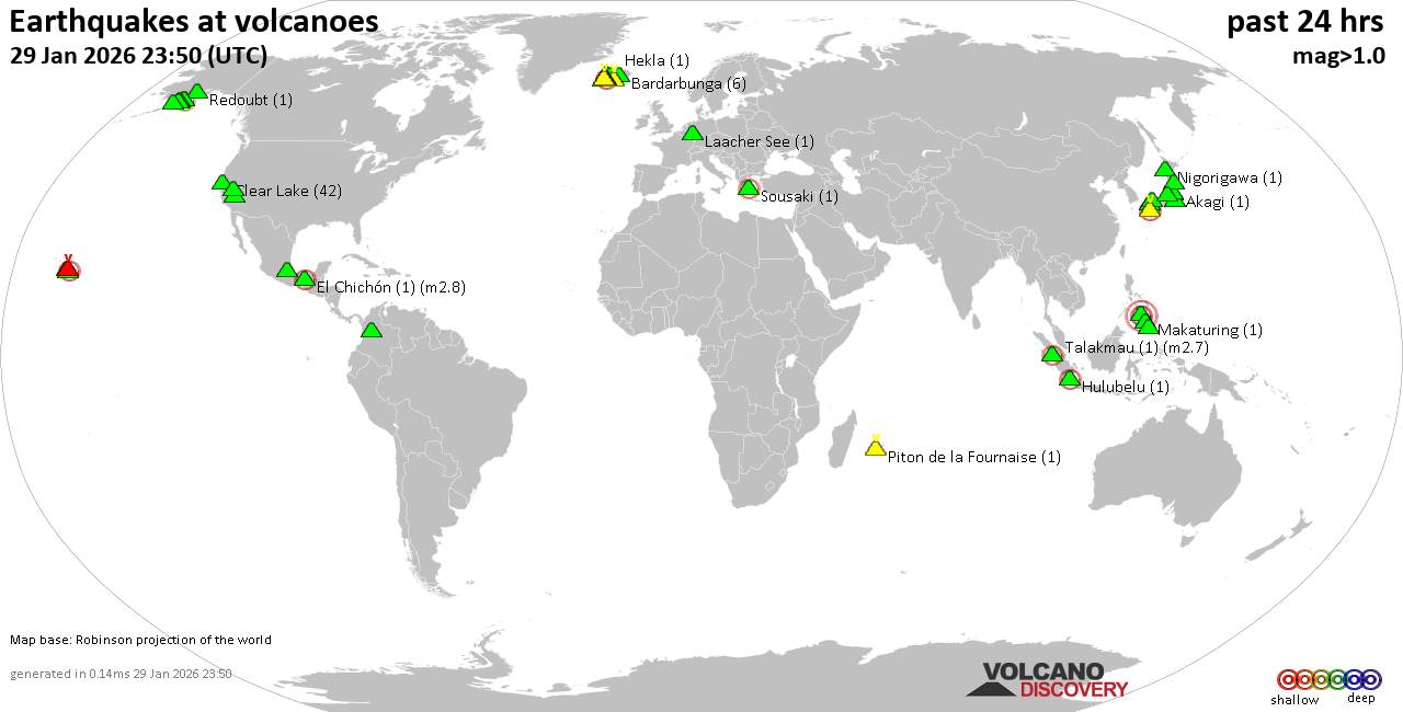 World map showing volcanoes with shallow (less than 50 km) earthquakes within 20 km radius during the past 24 hours on 29 Jan 2026 Number in brackets indicate nr of quakes. Quakes detected near: Abu (4 quakes between mag 0.7-1.3), Akagi (1 quake mag 1.4), Aso (3 quakes between mag 0.5-2.2), Bardarbunga (6 quakes between mag 0.6-1.2), Brennisteinsfjöll (3 quakes between mag 0.5-2.0), Clear Lake (42 quakes between mag 0.2-1.7)
Coso (3 quakes between mag 0.9-1.5), Cuernos de Negros (1 quake mag 3.0), El Chichón (1 quake mag 2.8), Eldey (20 quakes between mag 0.9-2.9), Hakone (1 quake mag 1.0), Hekla (1 quake mag 1.3), Hiuchi (2 quakes between mag 1.3-1.5), Hrómundartindur (22 quakes between mag 0.2-1.8), Hulubelu (1 quake mag 2.2), Kaguyak (1 quake mag 2.2), Katla (6 quakes between mag 0.4-2.5), Katmai (2 quakes between mag 1.0-1.2), Kilauea (3 quakes between mag 1.7-2.3), Krísuvík (1 quake mag 1.3), Kurikoma (2 quakes between mag 0.4-1.0), La Malinche (1 quake mag 3.0), Laacher See (1 quake mag 1.2), Ljósufjöll (2 quakes between mag 0.7-1.0), Loihi (2 quakes between mag 1.8-1.9), Long Valley (1 quake mag 3.0), Makaturing (1 quake mag 1.3), Martin (1 quake mag 1.1), Matutum (1 quake mag 1.9), Maunaloa (1 quake mag 3.3), Nigorigawa (1 quake mag 1.3), Piton de la Fournaise (1 quake mag 1.0), Prestahnukur (4 quakes between mag 1.0-1.8), Redoubt (1 quake mag 1.2), San Diego (1 quake mag 1.6), Sanbe (2 quakes between mag 0.9-1.1), Sousaki (1 quake mag 2.0), Svartsengi (1 quake mag 1.4), Talakmau (1 quake mag 2.7), Ugashik-Peulik (1 quake mag 1.4), Washiba-Kumonotaira (8 quakes between mag 0.3-1.3) (updated 23h50)
Note: Earthquakes within 20 km from and at depths less than 50 km under active volcanoes are reported. The list is not complete because many volcanoes are not monitored and/or seismic data in high resolution is not available publicly.
Volcanoes with recent earthquakes above magnitude 2 or more than 10 quakes are listed below:
Aso volcano (Kyushu): 3 earthquakes up to magnitude 2.23 earthquakes occurred near (under) the volcano during 16 hours, the last being recorded quake 2 hours ago. Hypocenter depths ranged between 10.30 and 9.40 km. Earthquake details: 2.2 quake 5.9 km north of Aso, Kumamoto, Japan, Jan 29, 2026 02:57 pm (GMT +9) (12 km N) 0.5 quake 45 km northeast of Kumamoto, Kumamoto, Japan, Jan 30, 2026 06:42 am (GMT +9) (13 km N) 0.5 quake 43 km northeast of Kumamoto, Kumamoto, Japan, Jan 29, 2026 04:01 pm (GMT +9) (12 km N) All earthquakes at AsoClear Lake volcano (California): 42 earthquakes up to magnitude 1.7Possible earthquake swarm: 42 earthquakes occurred near (under) the volcano during 24 hours, the last being recorded quake 21 minutes ago. Hypocenter depths ranged between 11.73 and 0.09 km. Earthquake details: (only 5 largest) 1.7 quake Sonoma County, 15 mi southwest of Clearlake, Lake County, California, United States, Jan 29, 2026 10:06 am (GMT -8) (17 km SSW) 1.6 quake Sonoma County, 13 mi southwest of Clearlake, Lake County, California, United States, Jan 29, 2026 06:42 am (GMT -8) (15 km SSW) 1.5 quake Sonoma County, 13 mi southwest of Clearlake, Lake County, California, United States, Jan 28, 2026 06:37 pm (GMT -8) (17 km S) 1.4 quake 25 mi north of Santa Rosa, Sonoma County, California, United States, Jan 29, 2026 02:04 pm (GMT -8) (18 km S) 1.4 quake 27 mi north of Santa Rosa, Sonoma County, California, United States, Jan 29, 2026 10:59 am (GMT -8) (17 km SSW) All earthquakes at Clear LakeCuernos de Negros volcano (Central Philippines): magnitude 3.0 earthquakeA magnitude 3.0 earthquake occurred at the volcano 5 hours ago. The quake, which might be volcanic in origin, was located at a depth of 10.00 km depth at 11 km distance SE from the volcano. Earthquake details: Reported seismic-like event (likely no quake): 16 km southwest of Dumaguete, Philippines, Jan 30, 2026 02:27 am (GMT +8) (11 km SE) All earthquakes at Cuernos de NegrosEl Chichón volcano (Southern Mexico): magnitude 2.8 earthquakeA magnitude 2.8 earthquake occurred at the volcano 23 hours ago. The quake, which might be volcanic in origin, was located at a depth of 3.00 km depth at 1 km distance SSW from the volcano. Earthquake details: 2.8 quake Estado de Chiapas, 38 km southwest of Teapa, Estado de Tabasco, Mexico, Jan 29, 2026 01:17 am (Universal Time) (1 km SSW) All earthquakes at El ChichónEldey volcano (Iceland): 20 earthquakes up to magnitude 2.9Possible earthquake swarm: 20 earthquakes occurred near (under) the volcano during 4 hours, the last being recorded quake 40 minutes ago. Hypocenter depths ranged between 14.70 and 1.10 km. Earthquake details: (only 5 largest) 2.9 quake Irminger Sea, 87 km southwest of Reykjavik, Capital Region, Iceland, Jan 29, 2026 07:37 pm (Reykjavik time) (17 km WSW) 2.4 quake Iceland: 2.9 km WNW of Geirfugladrangur Jan 29, 2026 09:45 pm (Reykjavik time) (17 km WSW) 2.3 quake Iceland: 2.1 km NW of Geirfugladrangur Jan 29, 2026 11:09 pm (Reykjavik time) (16 km WSW) 2.1 quake Iceland: 0.6 km NNW of Geirfugladrangur Jan 29, 2026 09:03 pm (Reykjavik time) (15 km WSW) 2.0 quake Iceland: 3.5 km WSW of Geirfugladrangur Jan 29, 2026 07:38 pm (Reykjavik time) (19 km WSW) All earthquakes at EldeyEldey is located at the beginning of the Reykjanes Ridge off the SW tip of Iceland. Its highest elevation is the top of Eldey Island, but most of the volcanic edifice is submerged. Several eruptions occurred in historic times, last in 1926. Hrómundartindur volcano (Iceland): 22 earthquakes up to magnitude 1.8Possible earthquake swarm: 22 earthquakes occurred near (under) the volcano during 19 hours, the last being recorded quake 5 hours ago. Hypocenter depths ranged between 10.20 and 4.30 km. Earthquake details: (only 5 largest) 1.8 quake 2.9 km NNW of Skálafell Jan 29, 2026 03:28 pm (Universal Time) (9 km SW) 1.6 quake 2.4 km N of Hellisheiðarvirkjun Jan 29, 2026 08:12 am (Universal Time) (9 km W) 1.1 quake Iceland: 3.2 km E of Hveradalir Jan 29, 2026 03:26 pm (Reykjavik time) (9 km SW) 0.9 quake 1.8 km W of Þrengsli Jan 28, 2026 11:52 pm (Universal Time) (16 km WSW) 0.8 quake 2.9 km NNW of Raufarhólshellir Jan 29, 2026 12:41 pm (Universal Time) (16 km SW) All earthquakes at HrómundartindurHulubelu volcano (Sumatra): magnitude 2.2 earthquakeA magnitude 2.2 earthquake occurred at the volcano 8 hours ago. The quake, which might be volcanic in origin, was located at a depth of 5.00 km depth at 4 km distance NNW from the volcano. Earthquake details: 2.2 quake Kabupaten Tanggamus, 79 km west of Bandar Lampung, Indonesia, Jan 29, 2026 10:35 pm (GMT +7) (4 km NNW) All earthquakes at HulubeluKaguyak volcano (Alaska Peninsula): magnitude 2.2 earthquakeA magnitude 2.2 earthquake occurred at the volcano 13 hours ago. The quake, which might be volcanic in origin, was located at a depth of 32.30 km depth at 11 km distance SSE from the volcano. Earthquake details: 2.2 quake 76 mi northwest of Kodiak, Kodiak Island Borough, Alaska, United States, Jan 29, 2026 01:22 am (GMT -9) (11 km SSE) All earthquakes at KaguyakKatla volcano (Iceland): 6 earthquakes up to magnitude 2.56 earthquakes occurred near (under) the volcano during 9 hours, the last being recorded quake 6 hours ago. Hypocenter depths ranged between 6.10 and 0.10 km. Earthquake details: (only 5 largest) 2.5 quake 5.9 km E of Goðabunga Jan 29, 2026 08:58 am (Universal Time) (4 km WNW) 2.4 quake 6.0 km E of Goðabunga Jan 29, 2026 08:58 am (Universal Time) (4 km W) 2.2 quake 6.0 km E of Goðabunga Jan 29, 2026 09:01 am (Universal Time) (4 km WNW) 2.2 quake 6.1 km E of Goðabunga Jan 29, 2026 08:50 am (Universal Time) (4 km W) 1.3 quake Iceland: 2.7 km WNW of Goðabunga Jan 29, 2026 09:00 am (Reykjavik time) (12 km W) All earthquakes at KatlaKilauea volcano (Hawai'i (Big Island)): 3 earthquakes up to magnitude 2.33 earthquakes occurred near (under) the volcano during 16 hours, the last being recorded quake 2 hours ago. Hypocenter depths ranged between 30.06 and 3.11 km. Earthquake details: 2.3 quake 9.2 mi northeast of Pāhala, Hawaii County, Hawaii, United States, Jan 28, 2026 07:38 pm (GMT -10) (18 km SSW) 2.0 quake 30 mi south of Hilo, Hawaii County, Hawaii, United States, Jan 29, 2026 11:31 am (GMT -10) (12 km SE) 1.7 quake 28 mi south of Hilo, Hawaii County, Hawaii, United States, Jan 29, 2026 10:35 am (GMT -10) (15 km ESE) All earthquakes at KilaueaLa Malinche volcano (Western & Central Mexico): magnitude 3.0 earthquakeA magnitude 3.0 earthquake occurred at the volcano 8 hours ago. The quake, which might be volcanic in origin, was located at a depth of 10.00 km depth at 17 km distance N from the volcano. Earthquake details: Reported seismic-like event (likely no quake): 22 km east of Tlaxcala, Estado de Tlaxcala, Mexico, Jan 29, 2026 09:42 am (GMT -6) (17 km N) All earthquakes at La MalincheLong Valley volcano (California): magnitude 3.0 earthquakeA magnitude 3.0 earthquake occurred at the volcano 3 hours ago. The quake, which might be volcanic in origin, was located at a depth of 10.00 km depth at 19 km distance SE from the volcano. Earthquake details: Reported seismic-like event (likely no quake): 15 mi east of Mammoth Lakes, Mono County, California, United States, Jan 29, 2026 01:18 pm (GMT -8) (19 km SE) All earthquakes at Long ValleyMaunaloa volcano (Hawai'i (Big Island)): magnitude 3.3 earthquakeA magnitude 3.3 earthquake occurred at the volcano 52 minutes ago. The quake, which might be volcanic in origin, was located at a depth of 7.44 km depth at 8 km distance WSW from the volcano. Earthquake details: 3.3 quake 20 mi southeast of Holualoa, Hawaii County, Hawaii, United States, Jan 29, 2026 12:58 pm (GMT -10) (8 km WSW) All earthquakes at MaunaloaTalakmau volcano (Sumatra): magnitude 2.7 earthquakeA magnitude 2.7 earthquake occurred at the volcano 18 hours ago. The quake, which might be volcanic in origin, was located at a depth of 15.00 km depth at 7 km distance SSW from the volcano. Earthquake details: 2.7 quake Kabupaten Pasaman Barat, 58 km northwest of Bukittinggi, Indonesia, Jan 29, 2026 12:38 pm (GMT +7) (7 km SSW) All earthquakes at Talakmauhttps://www.volcanodiscovery.com/earthquakes-volcanoes/news/293269/Volcano-earthquake-report-for-Thursday-29-Jan-2026.html
|
|


CMS The Best Conveyancing solicitors conveyancing quotes throughout the UK
For any webhosting enquiries please email webmaster@aus-city.com
|
|
Entire Thread
|

 Volcano earthquake report for Thursday, 29 Jan 2026
|
Webmaster
|
Yesterday at 11:50 PM
|
|
Forums60
Topics759,466
Posts794,181
Members2,958
| |
Most Online17,963
Jan 15th, 2026
|
|
|
|
|
Copyright 1996 - 2026 by David Cottle. Designed by David Bate Jr. All Rights Reserved.
By using this forum, the user agrees not to transfer any data or technical information received under the agreement, to any other entity without the express approval of the AUS-CITY Forum Admins and/or authors of individual posts (Forum Admins and DoD/USSPACECOM for the analysis of satellite tracking data).
Two-line elements (TLE) and all other satellite data presented and distributed via this forum and e-mail lists of AUS-CITY are distributed with permission from DoD/USSTRATCOM.

Reprise Hosting

|

|


 - Click image for larger picture.")


